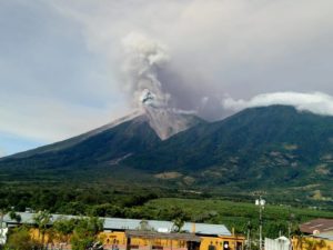
November 16 , 2023.
Iceland , Reykjanes Peninsula :
Situation unchanged since yesterday. Fiber optic cable of HS Orka is used as a continuous seismic monitoring line
Updated 15. November at 11:30 UTC
Since midnight, about 800 earthquakes have been measured, most of them in the middle of the magma dyke at Sundhnúk at a depth of about 3-5 km. Seismic activity has remained constant since 11th of November. The main monitoring focus on seismic activity remains in the area of the dike and Grindavík.
Deformation measurements show continued deformation in the area. They are consistent with magma still flowing into the dyke. Part of the magma dyke seems to be solidifying, especially at the edges, but not at the magma inflow area, which is believed to be near Sundhnúk.
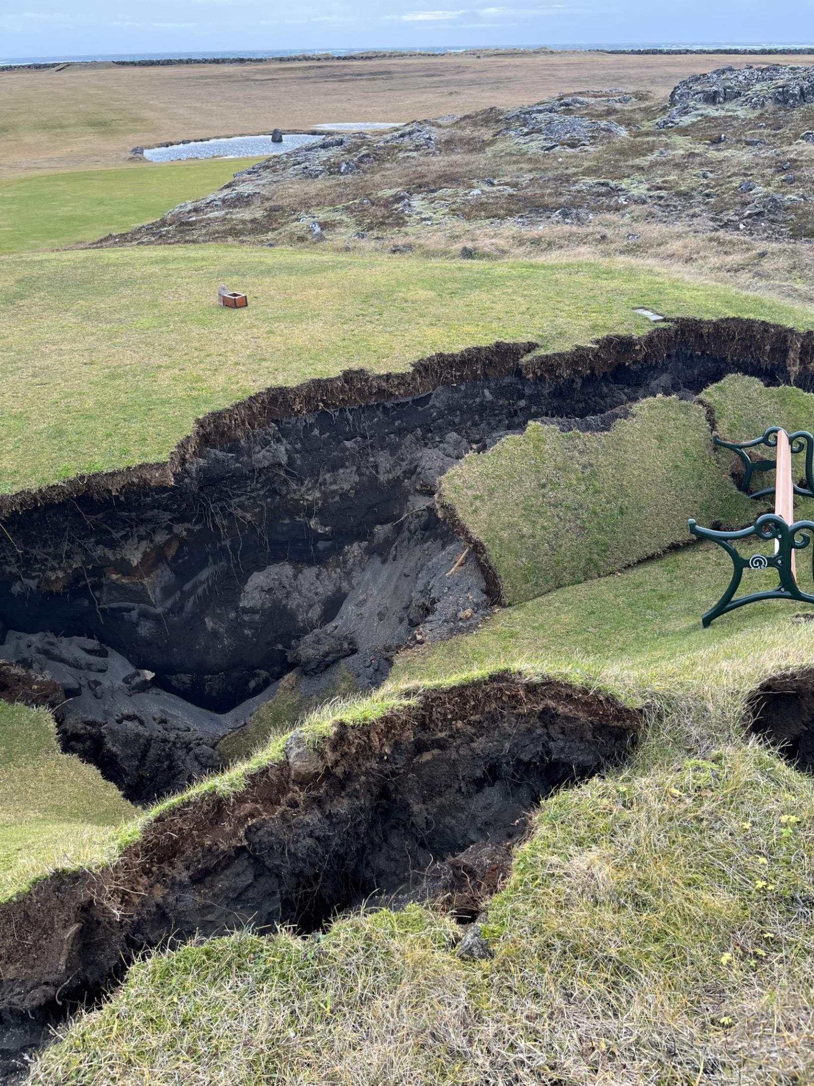
“The golf course looks incredible considering the conditions and what’s happened in the last few days. I thought it would be much worse,” says Helgi Dan Steinsson, CEO of the Grindavík Golf Club, who had just returned from a field trip around the golf course in Grindavík when mbl.is contacted him.
Measurements of sulfur dioxide (SO2) seem to show fluctuating degassing due to the magma dyke, but further measurements are needed for confirmation. Analysis of this data is currently underway in collaboration with the Chalmers University in Sweden.
The fiber optic cable of HS Orka, that runs from Svartsengi west of Þorbjörn to Arfadalsvík is beeing used as a continuous seismic measuring line with high sensitivity. This is a new technology that has developed in recent years and is now used as additional measurements in collaboration with HS Orku and ETH in Switzerland.
Overall, the situation seems to be unchanged since yesterday. The probability of an eruption is still considered high. In the event of an eruption, the most likely location is at the magma dyke.
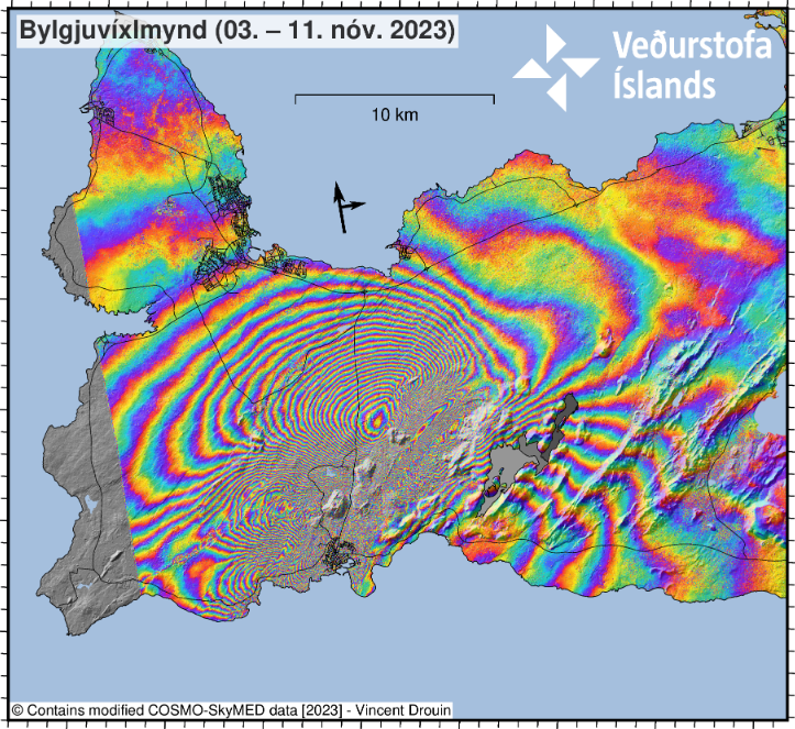
Geodetic models on 12 November showed that an area of inflation was located 3.5 km N of Grindavík, close to Sundhnúkur. Approximately 1,000 earthquakes, less than M 3.0, were detected N of Grindavík at 3-5 km depths between 00h00 and 12h30 on 12 November. On 13 November, the size and intensity of earthquakes decreased, when approximately 900 earthquakes were detected at depths of 2-5 km between 00h00 and 16h20 in the area between Sundhnúkur and Grindavík. During 12-13 November, calculations estimated that the magma inflow to the intrusion was 75 cubic meters per second. Between 00h00 and 12h40 on 14 November, 700 earthquakes occurred at depths of 3-5 km along the intrusion; the largest was M 3.1. After IMO installed two Differential Optical Absorption Spectrometers (DOAS, remote sensing gas instruments) on Húsafell, one of them detected SO2 at the graben-like feature between Sundhnúkagígar and Grindavík, but the source was unknown. Additional GPS stations have also been installed to monitor deformation.
Source : IMO, GVP.
Photos : MBL IS , COSMO-SkyMed/ IMO.
Alaska , Shishaldin :
54°45’19 » N 163°58’16 » W,
Summit Elevation 9373 ft (2857 m)
Current Volcano Alert Level: WATCH
Current Aviation Color Code: ORANGE
Unrest continues at Shishaldin Volcano. Seismic activity remains elevated with ongoing seismic tremor and small, low-frequency earthquakes. Satellite images indicated elevated surface temperatures at the summit crater in clear views overnight.
Thirteen significant explosive events have occurred at Shishaldin since July 12 through October 3, 2023. These events have been preceded by increases in seismicity in the hours to days before they occur. It is unknown how long this period of ongoing activity will last. However, previous eruptions of Shishaldin Volcano have lasted weeks to months with repeated cycles of eruptive activity like those seen since July.
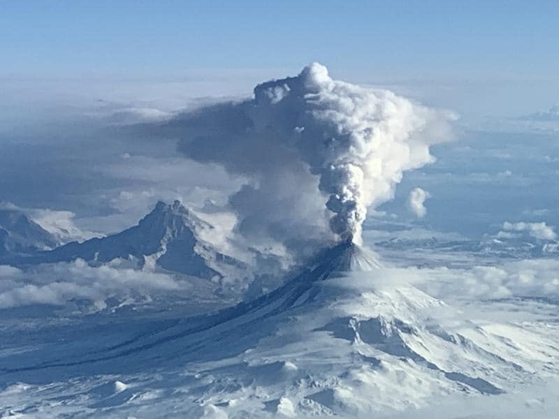
Local seismic and infrasound sensors, web cameras, and a geodetic network monitor Shishaldin Volcano. In addition to the local monitoring network, AVO uses nearby geophysical networks, regional infrasound and lighting data, and satellite images to detect eruptions.
AVO reported that eruptive activity continued at Shishaldin during 8-14 November. Seismicity remained elevated; the seismic network recorded ongoing tremor events and small, low-frequency earthquakes. During 8 November, infrasound sensors detected signals associated with small explosions, and a sulfur dioxide plume was detected by satellite sensors; material ejected during the explosions likely remained confined within the summit crater. Elevated surface temperatures of the summit crater were detected in satellite data during the nights of 11-13 November. Gas-and-steam emissions were occasionally seen in webcam and satellite images; views were obscured by weather clouds most days.
Source : AVO , GVP
Photo : Matt Brekke.
Japan , Sakurajima :
JMA reported ongoing activity at Minamidake Crater (Aira Caldera’s Sakurajima volcano) during 8-14 November. Sulfur dioxide emissions averaged 2,700 tons per day measured on 6 November. A total of 15 explosions were recorded during 6-10 November, and a total of 8 during 10-13 November. At 22h40 on 11 November an ash plume rose as high as 1.2 km above the crater rim and drifted SE and SW, large blocks were ejected 400 m from the summit crater, and crater incandescence was observed. At 20h53 on 13 November an explosion generated an ash plume that rose 400 m above the crater and drifted SW. The Alert Level remained at 3 (on a 5-level scale), and the public was warned to stay 2 km away from both craters.
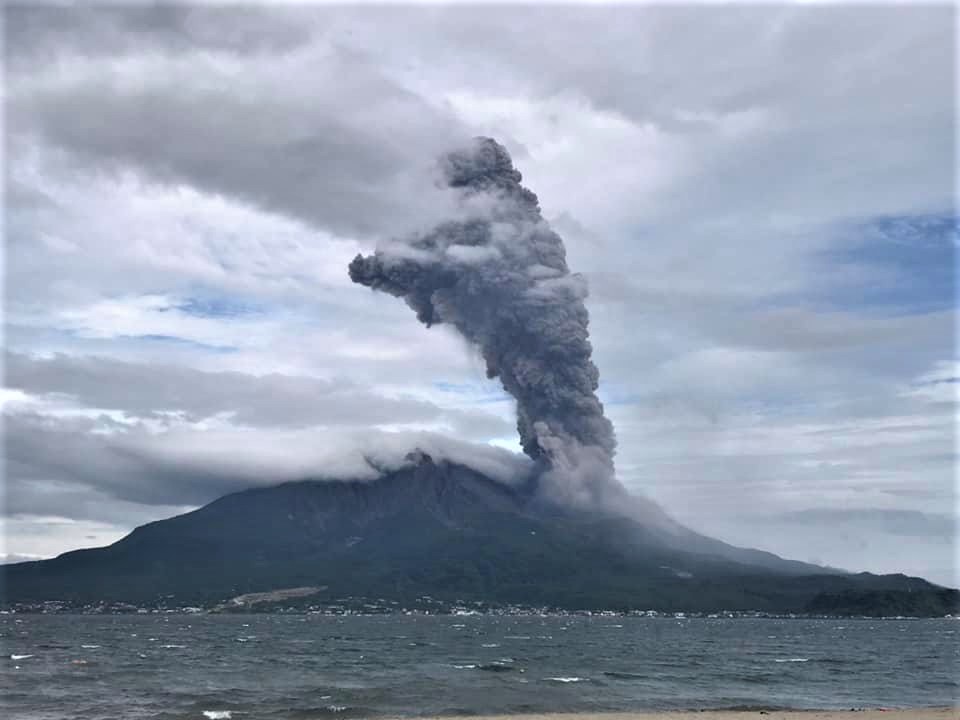
The Aira caldera in the northern half of Kagoshima Bay contains the post-caldera Sakurajima volcano, one of Japan’s most active. Eruption of the voluminous Ito pyroclastic flow accompanied formation of the 17 x 23 km caldera about 22,000 years ago. The smaller Wakamiko caldera was formed during the early Holocene in the NE corner of the caldera, along with several post-caldera cones. The construction of Sakurajima began about 13,000 years ago on the southern rim and built an island that was joined to the Osumi Peninsula during the major explosive and effusive eruption of 1914. Activity at the Kitadake summit cone ended about 4,850 years ago, after which eruptions took place at Minamidake. Frequent eruptions since the 8th century have deposited ash on the city of Kagoshima, located across Kagoshima Bay only 8 km from the summit. The largest recorded eruption took place during 1471-76.
Sources : Agence météorologique japonaise (JMA) , GVP.
Photo : Koki Arima ( archive)
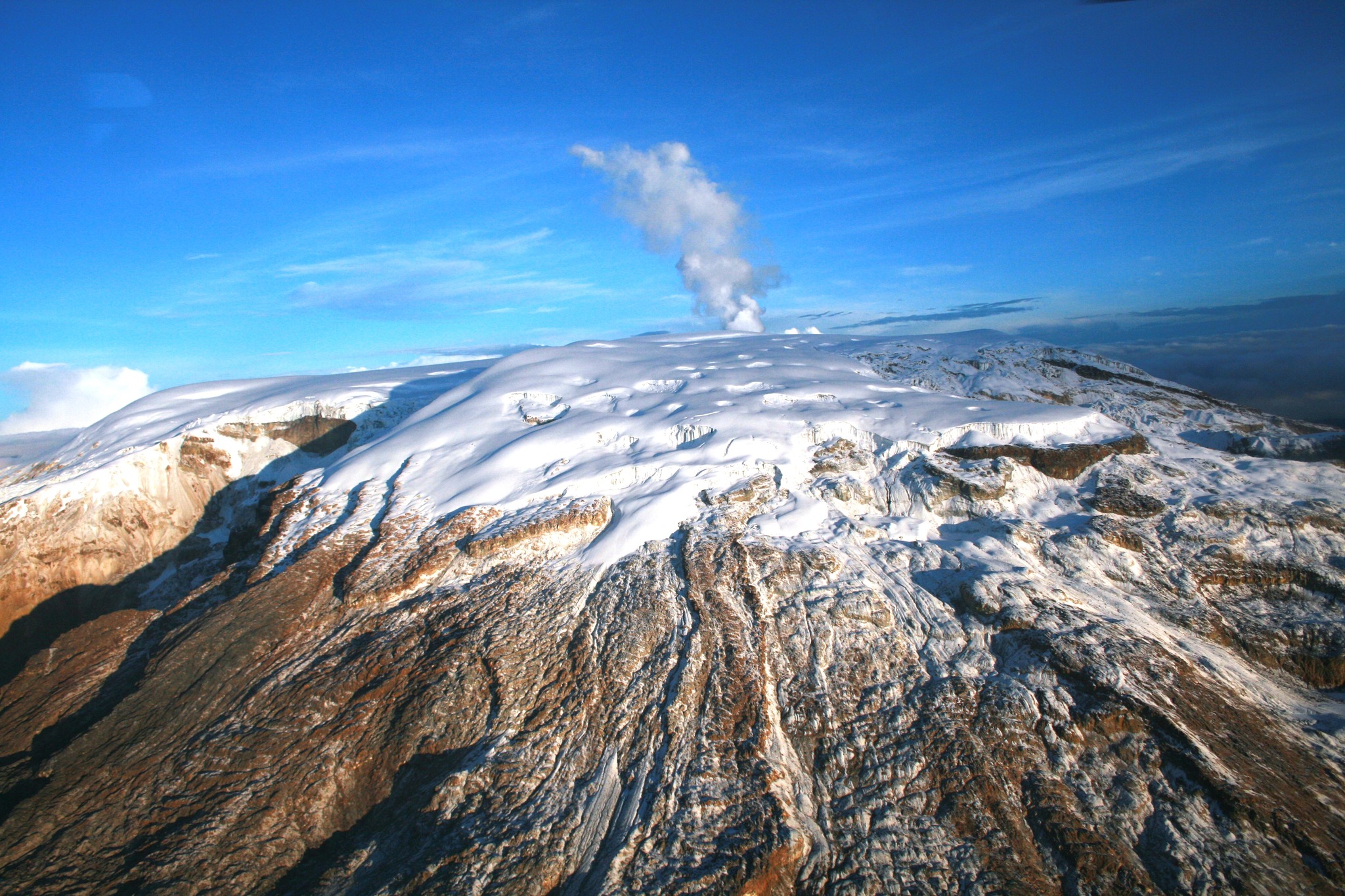
Colombia , Nevado del Ruiz :
Weekly bulletin on the activity of the Nevado del Ruiz volcano
From the monitoring of the activity of the NEVADO DEL RUIZ VOLCANO, the MINISTRY OF MINES AND ENERGY through the COLOMBIAN GEOLOGICAL SERVICE (SGC) reports that:
In the week of November 7-13, 2023, the volcano continued to exhibit unstable behavior, characterized by low to moderate activity levels. Compared to the previous week, the main variations in the parameters monitored were:
– Seismic activity associated with the fracturing of rocks within the volcanic edifice has maintained similar levels in the number of earthquakes recorded and in the seismic energy released. The seismicity was located mainly in the Arenas crater and in the East-Southeast sector of the volcano (at a distance between 7 and 14 km from the crater) and, to a lesser extent, on the East-Northeast flank, at distances less than 4 km from the crater. The depths of the earthquakes varied between 1 and 8 km from the summit of the volcano. The highest magnitude was 1.5, corresponding to the earthquake of November 7 at 4:52 a.m., located about 10 km east-southeast of Arenas crater and 3 km deep. On November 10 and 13, low energy seismicity was recorded, linked to the activity of the lava dome (protuberance or mound) located at the bottom of the crater.
– Seismicity linked to the activity of fluids inside volcanic conduits has decreased in the number of earthquakes recorded and increased in the seismic energy released.
This has been noticeable over the past couple of days, due to the longer duration of some seismic signals. Energy levels of this type of seismicity were low to sometimes moderate. Several of the seismic signals were associated with pulsatile emissions of gas or ash into the atmosphere or changes in the relative temperature of the emitted material. Both phenomena were confirmed by the cameras used to monitor the volcano or by reports from staff of the Los Nevados National Natural Park (PNNN).
– The emission of water vapor and gas into the atmosphere continued at the volcano. Sulfur dioxide (SO2) outgassing rates remain high. On November 9 and 13, these reached values that had not been recorded since mid-2022. The column of gas or ash reached a vertical height and dispersion of 1,800 and 2, respectively 200 m (measured above the summit of the volcano). These values were estimated for the ash emission on November 13 at 5:16 a.m. Although the direction of dispersion of the column is variable, it predominated towards the North-West of the volcano and generated the impact of ash falls on several occasions in the Brisas and Valle de las Tumbas sectors of the PNNN.
– When monitoring thermal anomalies at the bottom of Arenas crater, from satellite monitoring platforms, several anomalies of low to moderate energy levels were detected. On November 9, significant values were recorded, which had not been observed since mid-October.
Source et photo : SGC
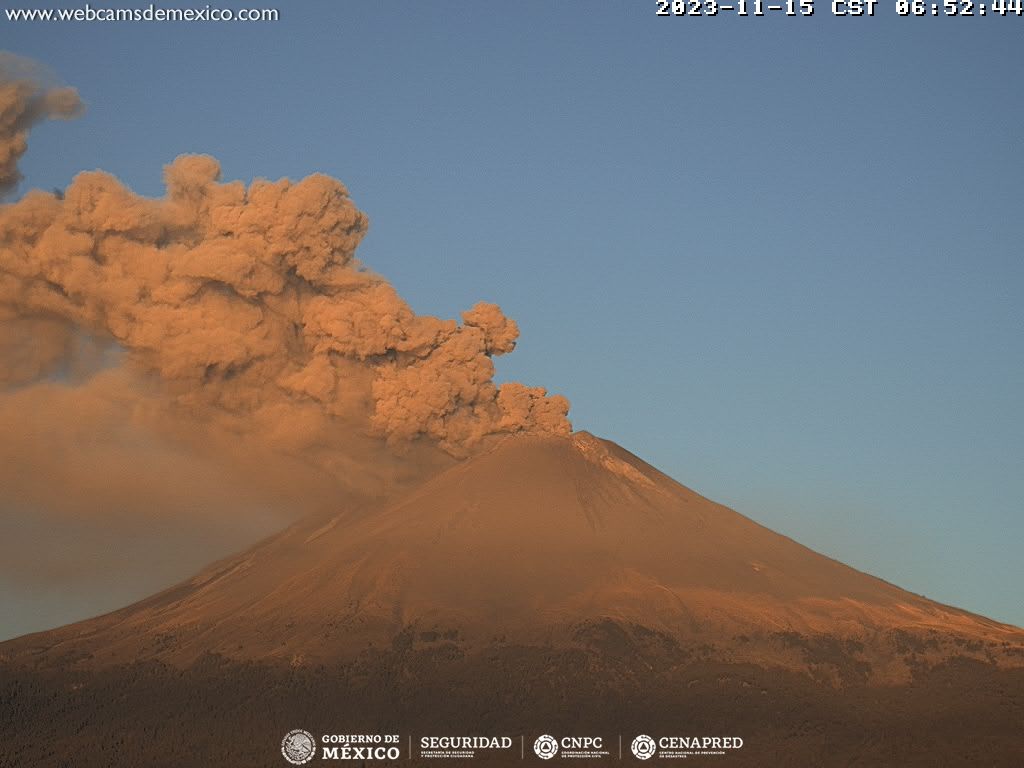
Mexico , Popocatepetl :
November 15, 11:00 a.m. (November 15, 5:00 p.m. GMT)
Activity from the last 24 hours
15 exhalations were detected, accompanied by emissions of volcanic gases and sometimes ash. Additionally, 1,034 minutes of tremor were recorded, identifying high frequency segments from very low to low amplitude totaling 17.23 hours.
The National Civil Protection Communications and Operations Center (Cenacom) reported yesterday at 4:21 p.m. light ash falls in the municipalities of Hueyapan and Tetela del Volcán, Morelos; and this morning in Chalco and Tlalmanalco, State of Mexico.
Since this morning and at the time of this report, we have observed a constant emission of water vapor, volcanic gases and ash, which is dispersing towards the South-South-West (SSW).
The Popocatépetl volcanic warning fire is in yellow phase 2.
CENAPRED reported that eruptive activity continued at Popocatépetl during 8-14 November. Long-period events totaling 9-156 per day were accompanied steam-and-gas plumes, and sometimes ash, that drifted NNE or NNW. Periods of low-amplitude and high-frequency volcanic tremor were recorded; between 284-1,323 minutes daily. According to the Washington VAAC, ash plumes rose as high as 6.4 km (21,000 ft) a.s.l., about 1 km above the summit, and drifted N, W, NW, and NNW during 8-9 November. During 10-13 November the VAAC reported ash plumes that rose as high as 6.7 km (22,000 ft) a.s.l. and drifted N, NNW, NE, NW and NNW. On 13 November a M 1.5 volcano-tectonic (VT) earthquake was detected at 03h39, and light ashfall was reported in Amecameca (19 km NW), Cocotitlán (34 km NW) and Tenango del Aire (101 km W), State of Mexico, and Ocuituco (22 km SW), State of Morelos. On 14 November ash plumes rose as high as 6 km (20,000 ft) a.s.l. and drifted N, NE, and SE, and light ashfall was reported in Cuernavaca, Morelos (64 km W). The Alert Level remained at Yellow, Phase Two (the second level on a three-color scale) and the public was warned to stay 12 km away from the crater.
Source : Cenapred , GVP.
Photo : Cenapred