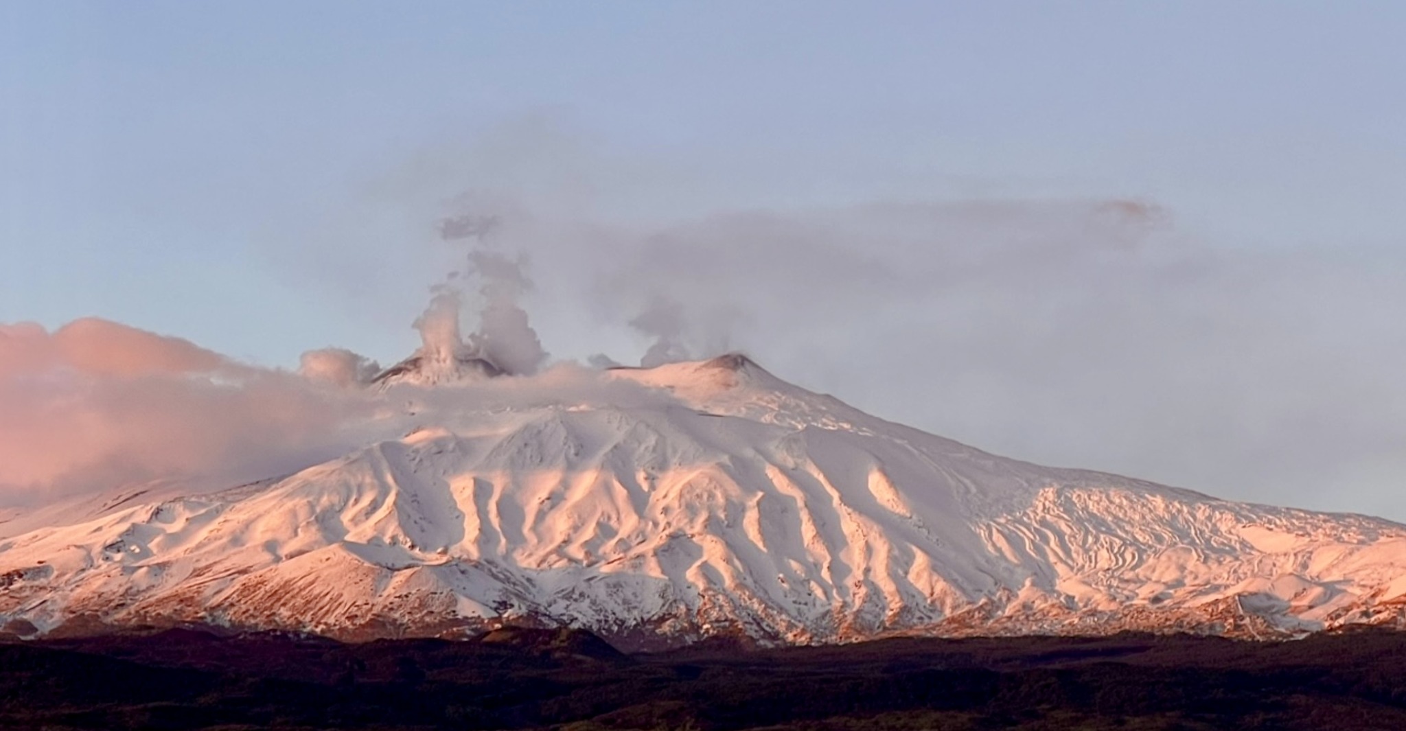
November 28, 2023. EN. Iceland : Reykjanes Peninsula , Peru : Sabancaya , Italy / Sicily : Etna , Indonesia : Anak Krakatau , Chile : Villarica .

November 28 , 2023.


Iceland , Reykjanes Peninsula :

Activity still located primarily near Sýlingarfell and Hagafell. A short-lived seismic swarm started at around midnight, 170 earthquakes were detected, the largest was M3
Updated 27. November at 16:30 UTC

Seismic activity has been relatively stable for the past few days with a daily rate of about 500 earthquakes in the area of the magmatic dike. Most of the seismicity continues to be nearby Sýlingarfell and Hagafell. Around midnight a short-lived seismic swarm commenced in the vicinity of Sýlingarfell and lasted for roughly one hour. A total of 170 earthquakes were detected in the area at a depth of 3-5 km. The earthquakes were almost all very small with one M3.0.

Data from GPS stations and satellite images show that uplift continues in the area of Svartsengi and deformation is still ongoing along and around the dike. The elevated seismic activity which occurred around midnight isn´t associated with any changes to the ongoing deformation. Both seismic and deformation data suggest that magma continues to accumulate beneath Svartsengi and to flow into the middle portion of the dike which formed on 10 November. The seismic swarm that occurred this night might indicate increasing pressure within the dike.

In light of the available data and the newest analysis, an eruption along the dike is still considered likely as long as the magma inflow continues. It is assessed that the area with the highest likelihood for an eruption is in the middle part of the dike between Hagafell and Sýlingarfell. The hazard map published by the IMO on 22 November remains valid.

Additional geodetical modelling has been performed to reconstruct the evolution of the dike which formed on 10 November. These newest results suggest that the dike at depth could be wider than initially assessed. The time needed to solidify the magma that intruded into the dike would be therefore estimated to be on the order of a few months.

Source et photo : IMO.


Peru , Sabancaya :

Analysis period: from November 20, 2023 to November 26, 2023, Arequipa, November 27, 2023.
Alert level: ORANGE

The Geophysical Institute of Peru (IGP) reports that the eruptive activity of the Sabancaya volcano remains at moderate levels, that is, with the recording of an average of 31 daily explosions, with columns of ash and of gas up to 2.9 km altitude above the summit of the volcano and their subsequent dispersion. Therefore, for the following days, no significant changes are expected regarding eruptive activity.

The IGP recorded and analyzed the occurrence of 130 earthquakes of volcanic origin, associated with the circulation of magmatic fluids inside the Sabancaya volcano. An average of 31 explosions were recorded daily, in addition to recording of Volcano-Tectonic (VT) type events associated with rock fracturing inside the Sabancaya volcano.

Monitoring the deformation of the volcanic structure using GNSS techniques (processed with fast orbits) does not present significant anomalies. However, in general, a slight inflation process was observed in the northern sector (around the Hualca Hualca volcano). Visual monitoring identified columns of gas and ash up to 2.9 km above the volcano summit, which were dispersed towards the northeast and southwest sectors of Sabancaya. Satellite recordings identified the presence of 13 thermal anomalies, with a maximum value of 10 MW, associated with the presence of a lava body on the surface of the volcano crater.

RECOMMENDATIONS
• Keep the volcano alert level in orange.
• Do not approach within a radius of less than 12 km from the crater.

Source : Cenvul.

Photo : Auteur inconnu ( archive)


Italy / Sicily , Etna :

Press release on the activity of Etna, November 2, 2023, 10:50 p.m. (9:50 p.m. UTC).

The National Institute of Geophysics and Volcanology, Osservatorio Etneo, communicates that according to the analysis of images from surveillance cameras, we observe that Strombolian activity persists in the Southeast crater. The activity varying in intensity and frequency produces modest emissions of ash which disperse quickly in the atmosphere near the summit area.

The average amplitude of the volcanic tremor continues to show a variable trend over time, with rapid oscillations between medium and high values and sources localized in the Southeast crater area. Regarding infrasound activity, the presence of high intensity wind did not allow us to make a reliable estimate of the frequency of appearance of infrasound events and their location. However, according to the visualization of the seismograms, where it was possible to make an evaluation, the sources are located in the Bocca Nuova crater area and in the Southeast crater area.
Analysis of signals from the inclinometer network and extensometers does not show any significant deformation of the ground over the last few hours.

Further updates will be communicated shortly.

Source : INGV.

Photo : Guide Etna Nord – Compagnia Guide Etna


Indonesia , Anak Krakatau  :

An eruption of Mount Anak Krakatau occurred on Tuesday, November 28, 2023 at 1:21 p.m. WIB. The height of the eruptive column was observed to be ±1,000 m above the peak (±1,157 m above sea level). The ash column was observed to be black with thick intensity, oriented towards the Northeast. The eruption was recorded on a seismograph with a maximum amplitude of 70 mm and a duration of 46 seconds.

VOLCANO OBSERVATORY NOTICE FOR AVIATION – VONA

Issued : November 28 , 2023
Volcano : Anak Krakatau (262000)
Current Aviation Colour Code : ORANGE
Previous Aviation Colour Code : orange
Source : Anak Krakatau Volcano Observatory
Notice Number : 2023KRA089
Volcano Location : S 06 deg 06 min 07 sec E 105 deg 25 min 23 sec
Area : Lampung, Indonesia
Summit Elevation : 502 FT (157 M)

Volcanic Activity Summary :
Eruption with volcanic ash cloud at 06h21 UTC (13h21 local).

Volcanic Cloud Height :
Best estimate of ash-cloud top is around 3702 FT (1157 M) above sea level or 3200 FT (1000 M) above summit. May be higher than what can be observed clearly. Source of height data: ground observer.

Other Volcanic Cloud Information :
Ash cloud moving to northeast. Volcanic ash is observed to be dark. The intensity of volcanic ash is observed to be thick.

Remarks :
Eruption recorded on seismogram with maximum amplitude 70 mm and maximum duration 46 second

Several intense eruptions took place today on the volcano at 02:04, 02:15, 03:51, 04:38 UTC, with altitudes between 957 m and 1657 m.

Source et photo : Magma Indonésie.


Chile , Villarica :

Special Report on Volcanic Activity (REAV), La Araucanía and Los Ríos regions, Villarrica volcano, November 27, 2023, 10:58 p.m. local time (mainland Chile)

The National Geology and Mining Service of Chile (Sernageomin) announces the following PRELIMINARY information, obtained through the monitoring equipment of the National Volcanic Monitoring Network (RNVV), processed and analyzed at the Southern Andean Volcano Observatory (Ovdas):

On Monday, November 27, 2023, at 10:38 p.m. local time (Tuesday, November 28, 1:38 a.m. UTC), monitoring stations installed near the Villarrica volcano recorded an earthquake associated with the fracturing of the rock (volcano-tectonic type).

The characteristics of the earthquake after its analysis are as follows:

ORIGINAL TIME: 10:38 p.m. local time (November 28, 2023, 01:38 UTC)
LATITUDE: 39.424°S
LONGITUDE: 71.892°E
DEPTH: 4.6 km
LOCAL MAGNITUDE: 3 (ML)

Observation :

During this day, an increase in volcano-tectonic activity was recorded, presenting local magnitude events of 1.7, 2.5 and 2.6 respectively, all with an epicenter similar to that previously described. Following the event, lower energy VT type earthquakes were recorded. No surface activity was observed, following cloudiness in the area.

At the time of issuing this report, the other seismic parameters did not show any variations.

The technical volcanic alert is maintained at YELLOW level.

Source : Sernageomin.

Photo : Auracaniadiario

28 Novembre 2023. FR. Islande : Péninsule de Reykjanes , Pérou : Sabancaya , Italie / Sicile : Etna , Indonésie : Anak Krakatau , Chili : Villarica .

28 Novembre 2023.


Islande , Péninsule de Reykjanes :

Activité toujours localisée principalement à proximité de Sýlingarfell et Hagafell. Un essaim sismique de courte durée a commencé vers minuit, 170 tremblements de terre ont été détectés, le plus important étant de M3
Mise à jour le 27 novembre à 16h30 UTC

L’activité sismique est relativement stable depuis quelques jours avec un rythme quotidien d’environ 500 séismes dans la zone du dyke magmatique. La majeure partie de la sismicité continue de se situer à proximité de Sýlingarfell et de Hagafell. Vers minuit, un essaim sismique de courte durée a commencé à proximité de Sýlingarfell et a duré environ une heure. Au total, 170 tremblements de terre ont été détectés dans la zone à une profondeur de 3 à 5 km. Les séismes étaient presque tous très faibles, avec un seul M3,0.

Les données des stations GPS et les images satellite montrent que le soulèvement se poursuit dans la région de Svartsengi et que la déformation est toujours en cours le long et autour du dyke. L’activité sismique élevée qui s’est produite vers minuit n’est associée à aucun changement dans la déformation en cours. Les données sismiques et de déformation suggèrent que le magma continue de s’accumuler sous Svartsengi et de s’écouler dans la partie médiane du dyke formé le 10 novembre. L’essaim sismique survenu cette nuit pourrait indiquer une augmentation de la pression à l’intérieur du dyke.

À la lumière des données disponibles et des analyses les plus récentes, une éruption le long du dyke est toujours considérée comme probable tant que l’afflux de magma se poursuit. On estime que la zone présentant la plus forte probabilité d’éruption se trouve dans la partie médiane du dyke entre Hagafell et Sýlingarfell. La carte des dangers publiée par l’OMI le 22 novembre reste valable.

Une modélisation géodésique complémentaire a été réalisée pour reconstituer l’évolution du dyke formée le 10 novembre. Ces résultats les plus récents suggèrent que le dyke en profondeur pourrait être plus large que ce qui avait été initialement évalué. Le temps nécessaire à la solidification du magma ayant pénétré dans le dyke serait donc estimé à quelques mois.

Source et photo : IMO.


Pérou , Sabancaya :

Période d’analyse: du 20 Novembre 2023 au 26 Novembre 2023 , Arequipa, 27 Novembre 2023 .
Niveau d’alerte: ORANGE

L’Institut géophysique du Pérou (IGP) rapporte que l’activité éruptive du volcan Sabancaya reste à des niveaux modérés, c’est-à-dire avec l’enregistrement d’une moyenne de 31 explosions quotidiennes , avec des colonnes de cendres et de gaz jusqu’à 2,9 km d’altitude au-dessus du sommet du volcan et leur dispersion consécutives . Par conséquent, pour les jours suivants, aucun changement significatif n’est attendu concernant l’ activité éruptive.

L’IGP a enregistré et analysé l’occurrence de 130 tremblements de terre d’origine volcanique, associés à la circulation de fluides magmatiques à l’intérieur du volcan Sabancaya. Une moyenne de 31 explosions a été enregistrée quotidiennement , en plus d’enregistrement d’évènements  de type Volcano-Tectoniques (VT) associés à des fracturations rocheuses à l’intérieur du volcan Sabancaya .


Le suivi de la déformation de la structure volcanique à l’aide de techniques GNSS (traitées avec des orbites rapides) ne présente pas d’anomalies significatives. Cependant, de manière générale, un léger processus d’inflation a été observé dans le secteur  Nord ( environs du volcan Hualca Hualca ). La surveillance visuelle a permis d’identifier des colonnes de gaz et de cendres jusqu’à 2,9  km d’altitude au-dessus du sommet du volcan , qui étaient dispersées vers les secteurs Nord-Est et Sud-Ouest du Sabancaya.  Les enregistrements par satellites ont identifiés la présence de 13 anomalies thermiques , avec une valeur maximale de 10 MW , associées à la présence d’un corps de lave à la superficie du cratère du volcan.

RECOMMANDATIONS
• Garder le niveau d’alerte volcanique en orange.
• Ne pas s’ approcher dans un rayon de moins de 12 km du cratère.

Source : Cenvul.

Photo : Auteur inconnu ( archive)


Italie / Sicile , Etna :

Communiqué sur l’activité de l’Etna , 2 Novembre 2023 , 22h50 (21h50 UTC) .

L’Institut National de Géophysique et Volcanologie, Osservatorio Etneo, communique que d’après l’analyse des images des caméras de surveillance, on observe que l’activité strombolienne persiste dans le cratère Sud-Est. L’activité variable en intensité et en fréquence produit de modestes émissions de cendres qui se dispersent rapidement dans l’atmosphère à proximité de la zone sommitale.

L’amplitude moyenne du tremor volcanique continue de montrer une tendance variable dans le temps, avec des oscillations rapides entre les valeurs moyennes et élevées et des sources localisées dans la zone du cratère Sud-Est. En ce qui concerne l’activité infrasonore, la présence de vent de forte intensité ne nous a pas permis de faire une estimation fiable de la fréquence d’apparition des événements infrasonores et de leur localisation. Cependant, d’après la visualisation des sismogrammes, où il a été possible de faire une évaluation, les sources sont situées dans la zone du cratère de la Bocca Nuova et dans la zone du cratère Sud-Est.
L’analyse des signaux du réseau inclinométrique et des extensomètres ne montre pas de déformations significatives du sol au cours des dernières heures.

D’autres mises à jour seront communiquées rapidement.

Source : INGV.

Photo : Guide Etna Nord – Compagnia Guide Etna


Indonésie , Anak Krakatau  :

Une éruption du mont Anak Krakatau s’est produite le mardi 28 novembre 2023 à 13h21 WIB. La hauteur de la colonne éruptive a été observée à ± 1 000 m au-dessus du pic (± 1 157 m au-dessus du niveau de la mer). La colonne de cendres a été observée comme étant noire avec une intensité épaisse , orienté vers le Nord-Est. L’éruption a été enregistrée sur un sismographe avec une amplitude maximale de 70 mm et une durée de 46 secondes.

AVIS D’OBSERVATION DU VOLCAN POUR L’AVIATION – VONA

Publié : 28 novembre 2023
Volcan : Anak Krakatau (262000)
Code couleur aviation actuel : ORANGE
Code couleur aviation précédent : orange
Source : Observatoire du Volcan Anak Krakatau
Numéro d’avis : 2023KRA089
Localisation du volcan : S 06 deg 06 min 07 sec E 105 deg 25 min 23 sec
Région : Lampung, Indonésie
Altitude du sommet : 502 pieds (157 m)

Résumé de l’activité volcanique :
Éruption avec nuage de cendres volcaniques à 06h21 UTC (13h21 locale).

Hauteur des Nuages Volcaniques :
La meilleure estimation du sommet du nuage de cendres se situe à environ 3 702 pieds (1 157 m) au-dessus du niveau de la mer ou 3 200 pieds (1 000 m) au-dessus du sommet. Peut être supérieur à ce qui peut être observé clairement. Source des données de hauteur : observateur au sol.

Autres informations sur les nuages volcaniques :
Nuage de cendres se déplaçant vers le Nord-Est. Les cendres volcaniques sont sombres. L’intensité des cendres volcaniques est observée comme étant épaisse.

Remarques :
Éruption enregistrée sur sismogramme avec une amplitude maximale de 70 mm et une durée maximale de 46 secondes.

Plusieurs éruptions intenses ont eu lieu aujourd’hui sur le volcan à 02h04 , 02h15 , 03h51 , 04h38 , heure UTC, avec des altitudes comprises entre 957 m et 1657 m.

Source et photo : Magma Indonésie.


Chili , Villarica :

Rapport spécial sur l’activité volcanique (REAV), régions de La Araucanía et Los Ríos, volcan Villarrica, 27 Novembre 2023, 22h58 heure locale (Chili continental)

Le Service national de géologie et des mines du Chili (Sernageomin) annonce les informations PRÉLIMINAIRES suivantes, obtenues grâce à l’équipement de surveillance du Réseau national de surveillance volcanique (RNVV), traitées et analysées à l’Observatoire des volcans des Andes du Sud (Ovdas) :

Le Lundi 27 Novembre 2023 , à 22h38 heure locale ( Mardi 28 Novembre 01h38 UTC) ,  les stations de surveillance installées à proximité du volcan Villarrica ont enregistré  un séisme associé à la fracturation de la roche ( type volcano-tectonique).

Les caractéristiques du séisme après son analyse sont les suivantes :

HEURE D’ORIGINE : 22h38, heure locale (28 novembre 2023, 01h38 UTC)
LATITUDE : 39,424° S
LONGITUDE: 71,892°E
PROFONDEUR : 4,6 km
MAGNITUDE LOCALE : 3 (ML)

Observation :


Durant cette journée , il a été enregistré une augmentation de l’activité volcano-tectonique , présentant des évènements de magnitude locales de 1,7 , 2,5 et 2,6 respectivement , tous avec un épicentre similaire à celui décrit précédemment . Suite à l’évènement , il a été enregistré des séismes de type VT de plus faible énergie. Il n’a pas été observé d’activité superficielle , suite à des nébulosités dans le zone.

Au moment de l’émission de ce rapport les autres paramètres sismiques ne présentent pas de variations..

L’alerte technique volcanique est maintenue au niveau JAUNE.

Source : Sernageomin.

Photo : Auracaniadiario