April 18 , 2024.
Indonésia , Ruang :
PVMBG reported that the number of deep volcanic earthquakes at Ruang increased each day during 10-15 April, with the total number significantly higher than from the entire month of March. During the morning of 16 April dense white plumes were visible rising 200-500 m above the summit and seismicity intensified. At 10h00 on 16 April the Alert Level was raised to 2 (on a scale of 1-4) and the public was warned to stay 2 km away from the crater.
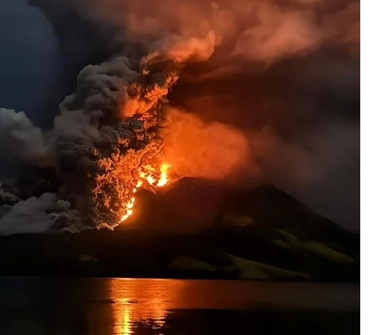
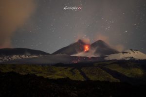
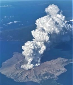
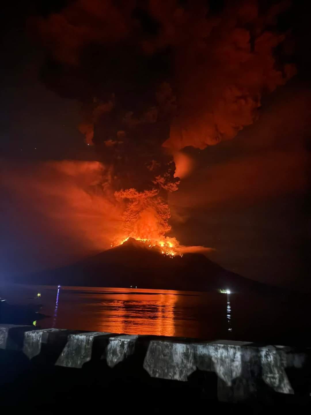
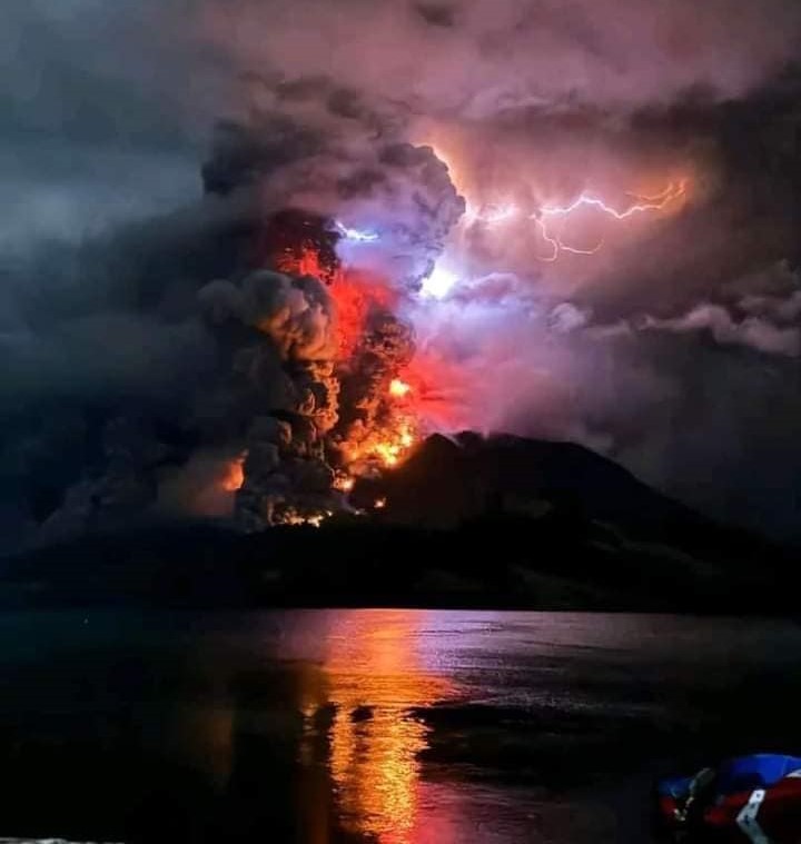
A minor eruption began at around 13h37 on 16 April. The Darwin VAAC noted that an ash plume was visible in a satellite image rising to 1.2 km (4,000 ft) a.s.l. and drifting SSW. At 16h00 the Alert Level was raised to 3. According to a news article a larger eruption began at 20h45 and ash plumes rose 2 km. The eruption intensified overnight during 16-17 April. The Darwin VAAC report that at 02h30 on 17 April ash plumes rose to 9.1 km (30,000 ft) a.s.l. and drifted W; another plume at 03h00 reached 12.2 km (40,000 ft) and detached from the summit. Ash plumes at a lower altitude, 4.6 km (15,000 ft) a.s.l., drifted WSW. At 06h00 ash plumes rose to 13.7 km (45,000 ft) a.s.l. and drifted W and NW. The plume was detached from the summit by 07h13. BNPB reported that 828 people evacuated and the communication network in Laingpatehi village was not operational. Photos showed incandescent material being ejected above the summit, incandescent material on the flanks, and dense ash plumes with lightning rising into dark, nighttime skies.
An eruption of Mount Ruang occurred on Wednesday, April 17, 2024 at 8:15 p.m. WITA with the height of the ash column observed at ±3000 m above the summit (±3725 m above sea level). The ash column was observed to be gray to black in color with thick intensity, oriented towards the South. At the time of writing, the eruption was still ongoing.
VOLCANO OBSERVATORY NOTICE FOR AVIATION – VONA
Issued : April 17 , 2024
Volcano : Ruang (267010)
Current Aviation Colour Code : ORANGE
Previous Aviation Colour Code : orange
Source : Ruang Volcano Observatory
Notice Number : 2024RUA003
Volcano Location : N 02 deg 18 min 11 sec E 125 deg 22 min 00 sec
Area : North Sulawesi, Indonesia
Summit Elevation : 2320 FT (725 M)
Volcanic Activity Summary :
Eruption with volcanic ash cloud at 12h15 UTC (20h15 local).
Volcanic Cloud Height :
Best estimate of ash-cloud top is around 11920 FT (3725 M) above sea level or 9600 FT (3000 M) above summit. May be higher than what can be observed clearly. Source of height data: ground observer.
Other Volcanic Cloud Information :
Ash cloud moving to south. Volcanic ash is observed to be brown to dark. The intensity of volcanic ash is observed to be thick.
Remarks :
Eruption and ash emission is continuing. Eruption recorded on seismogram with maximum amplitude 55 mm. Tremor recorded on seismogram with maximum amplitude 55 mm. Rumbling sound heard from Tagulandang
Increase in G.Ruang activity level from level III (SIAGA) to level IV (AWAS).
The seismicity of April 16 and 17, 2024 is as follows:
Earthquake of April 16, 2027:
Between 00:00 and 12:00 WITA, the number of deep volcanic earthquakes (VTA) was recorded at 198 events and 2 deep tectonic earthquakes occurred.
Between 12:00 and 24:00 WITA, the number of deep volcanic earthquakes (VTA) experienced an escalation of 493 events, 5 shallow volcanic earthquakes, 2 local tectonic earthquakes, and 1 distant tectonic earthquake.
Earthquake of April 17, 2027:
Between 00:00 and 12:00 WITA, the number of deep volcanic earthquakes (VTA) was recorded at 373 events, the number of shallow volcanic earthquakes (VTB) 564 events, 2 felt earthquakes and 1 tectonic earthquake local.
Between 12:00 p.m. and 8:15 p.m. WITA , 1 eruption earthquake occurred and continuous volcanic tremors with a maximum amplitude of 50 to 55 mm (dominant 55 mm).
Assessment
The height of the eruptive column tends to increase with the eruptive material in the form of ash accompanied by ejections of incandescent rock which reaches a distance of approximately 5 km on Tagulandang Island.
The number of occurrences of deep volcanic earthquakes has increased significantly, accompanied by continuous volcanic tremors with excessive amplitudes, indicating that there is currently still a process of rock cracking accompanied by migration of magma from the reservoirs of deep magma towards the surface in the form of explosive eruptions interspersed with effusive eruptions (lava flows).
Recommendation
Based on the results of visual and instrumental monitoring that show an increase in volcanic activity on Mount Ruang, the activity level of Mount Ruang was increased from level III (SIAGA) to level IV (AWAS) from from April 17, 2024 at 9:00 p.m. WITA. .
At the AWAS activity level it is recommended:
Communities around Mount Ruang and visitors/tourists should remain vigilant and not enter the area within a 6 km radius from the center of the active crater of Mount Ruang.
People living in the P. Tagulandang area within a 6 km radius should be immediately evacuated to a safe location outside the 6 km radius.
Residents of Tagulandang Island, especially those living near the coast, should be aware of the potential for ejection of glowing rocks, hot clouds (surges), and tsunamis caused by collapsing volcanic bodies in the sea.
Sources : Magma Indonésie, Pusat Vulkanologi et Mitigasi Bencana Geologi (PVMBG, également connu sous le nom de CVGHM), Badan Nacional Penanggulangan Bencana (BNPB), Jakarta Post, Darwin Volcanic Ash Advisory Center (VAAC) , GVP.
Photos : The Watchmen’s Earth and Space connection , Jro Yudhiani , Vian Apeles Togas .
Chile , Guallatiri :
Special Report on Volcanic Activity (REAV), Arica and Parinacota region, Guallatiri volcano, April 17, 2024, 8:50 p.m. local time (mainland Chile).
The National Service of Geology and Mines of Chile (Sernageomin) publishes the following PRELIMINARY information, obtained using the monitoring equipment of the National Volcanic Monitoring Network (RNVV), processed and analyzed at the Southern Andean Volcanological Observatory ( Ovdas):
On Wednesday April 17, at 8:34 p.m. local time (00:34 UTC), monitoring stations installed near the Guallatiri volcano recorded an earthquake associated with the fracturing of rocks (volcano-tectonic type).
![]()
The characteristics of earthquakes after their analysis are as follows:
ORIGINAL TIME: 8:34 p.m. local time (00:34 UTC)
LATITUDE: 18.418° S
LONGITUDE: 69.103°E
DEPTH: 0.4 km
LOCAL MAGNITUDE: 3.6 (ML)
OBSERVATIONS:
The technical volcanic alert remains at level Green.
Source et photo : Sernageomin.
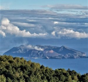
Japan , Kuchinoerabujima :
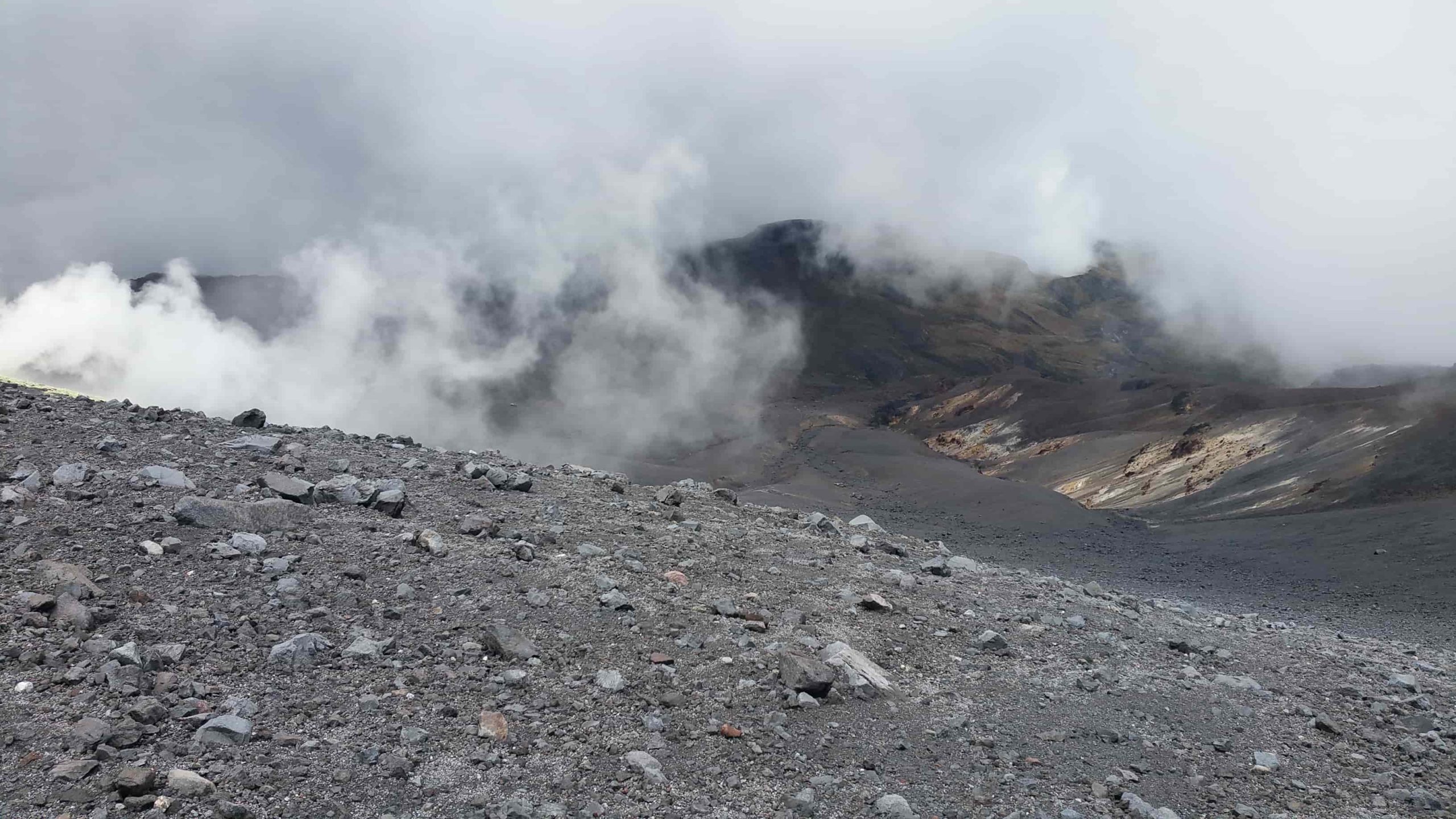
JMA reported that shallow volcanic earthquakes at Kuchinoerabujima had been frequent since the beginning of April, with most epicenters located near Furudake Crater, and some near Shindake Crater (just N of Furudake). Both the number and magnitude of the volcanic earthquakes increased and remained elevated. The Alert Level was raised to 3 (on a scale of 1-5) at 1200 on 13 April due to the increased seismicity. Visual observations during 10-12 April field visits indicated no changes to the craters nor to the geothermal area near the fissure on the W side of the Shindake. Sulfur dioxide gas emissions were at low levels. The public was warned that ejected blocks and pyroclastic flows may impact areas within 1 km of both craters and within 2 km of Shindake.
.
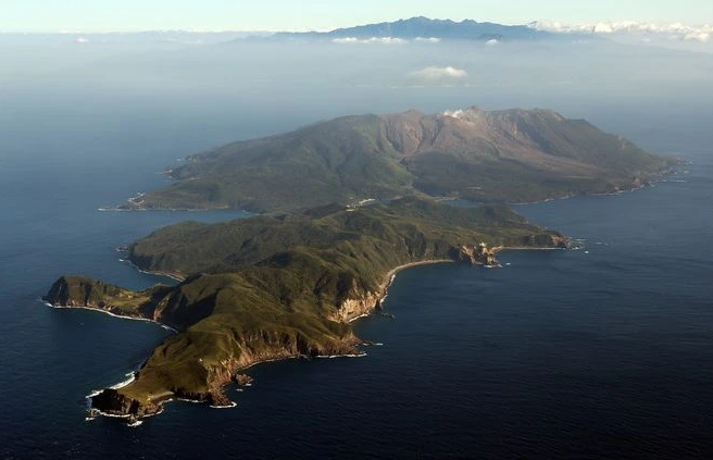
A group of young stratovolcanoes forms the eastern end of the irregularly shaped island of Kuchinoerabujima in the northern Ryukyu Islands, 15 km W of Yakushima. The Furudake, Shindake, and Noikeyama cones were erupted from south to north, respectively, forming a composite cone with multiple craters. All historical eruptions have occurred from Shindake, although a lava flow from the S flank of Furudake that reached the coast has a very fresh morphology. Frequent explosive eruptions have taken place from Shindake since 1840; the largest of these was in December 1933. Several villages on the 4 x 12 km island are located within a few kilometers of the active crater and have suffered damage from eruptions.
Sources : Agence météorologique japonaise (JMA) , GVP.
Photo : Asahi Shimbun
Colombia , Purace / Chaîne volcanique Los Coconucos :
Weekly activity bulletin: Puracé Volcano – Los Coconucos volcanic chain
From the monitoring of the activity of the VOLCANIC CHAIN PURACE VOLCANO – LOS COCONUCOS, the MINISTRY OF MINES AND ENERGY, through the COLOMBIAN GEOLOGICAL SERVICE (SGC), reports that:
In the week of April 9 to 15, 2024, seismic activity remained at levels comparable to the last four months, both in seismic energy released and in the number of events recorded. The fracture earthquakes continued to be located mainly on the southeastern flank of the Puracé volcano building, with depths between 1 and 4 km and magnitudes less than 0.7 ML, while the associated earthquakes The fluids were located in two areas: one below the crater of the volcano, with depths less than 500 m, and another of lesser importance to the South-East of it, at depths between 1 and 6 km.
During the period evaluated, the slow deformation process that began in April 2022 between the Puracé and Curiquinga volcanoes continues to be recorded. Likewise, the concentration of carbon dioxide (CO2) maintains a trend above reference values in this volcano and the increase in the flow of sulfur dioxide (SO2) detected in previous weeks continues to be observed.
Images obtained using installed cameras show that significant degassing of the volcanic system continues.
Other parameters measured for the assessment of volcanic activity showed no notable changes during the assessed period.
From the SGC we call on people who visit the Puracé National Natural Park not to approach the upper part of the Puracé and Curiquinga volcanoes, given that the increase in gas emissions into the atmosphere can cause problems of health.
The alert status for volcanic activity remains at: YELLOW ALERT: ACTIVE VOLCANO WITH CHANGES IN THE BEHAVIOR OF THE BASE LEVEL OF MONITORED PARAMETERS AND OTHER MANIFESTATIONS.
Source : SGC
Photo : Angel on travel.
Costa Rica , Poas :
Latitude: 10.20°N;
Longitude: 84.23°W;
Altitude: 2687 m
Current activity level: Warning
Following the rains, we observed a reduction in ash emissions, followed by a small explosive eruption on Sunday April 7, and the reappearance of bubbles (small phreatic eruptions) in the middle of this week. The intensity of the bubbles gradually increases. This increase continued until the water content in the C vent decreased sufficiently to allow further emission of ash, which occurred on the morning of Thursday, April 11. The amplitude of the seismic tremor decreased during the continuous emission of ash that occurred between March 30 and April 6. On April 7, two small eruptions were recorded (without visual confirmation) then the amplitude of the seismic tremor increased. The frequency of tremors decreased on April 10, accompanying a new eruptive phase characterized by thousands of small phreatic eruptions. These occurred approximately every 3 s, according to the infrasound recordings.
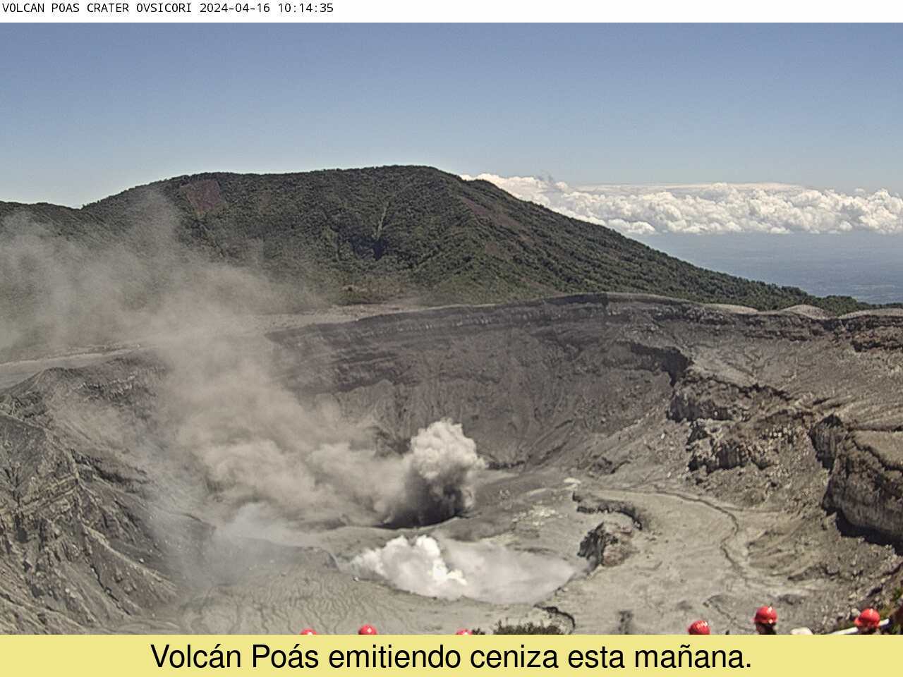
The volcano continues to emit ash continuously, without force. The plume remains at the height of the crater and disperses towards the South-West. The concentration of plume particles is variable and increases sporadically. Seismic activity is low with a discontinuous low-frequency tremor which coincides with the observation of an increase in particle concentration.
Over the past few weeks, degassing has been relatively stable or gradually decreasing. Based on data recorded by the MultiGAS permanent station, the highest peaks in SO2 concentrations (~15ppm) and SO2/CO2 ratio (~2.4) occurred during the last week of March. No significant increase has therefore been observed over the last 3 weeks. SO2 is still detected in the atmosphere thanks to satellite observation but the mass is decreasing compared to the previous week. On April 7, after the rains of recent days, residents of Bajos del Toro reported diluted ash falling into rivers in the region, such as the Desagüe River.
Source et photo : Ovsicori