April 07 , 2024.
Indonesia , Lewotobi Laki Laki :
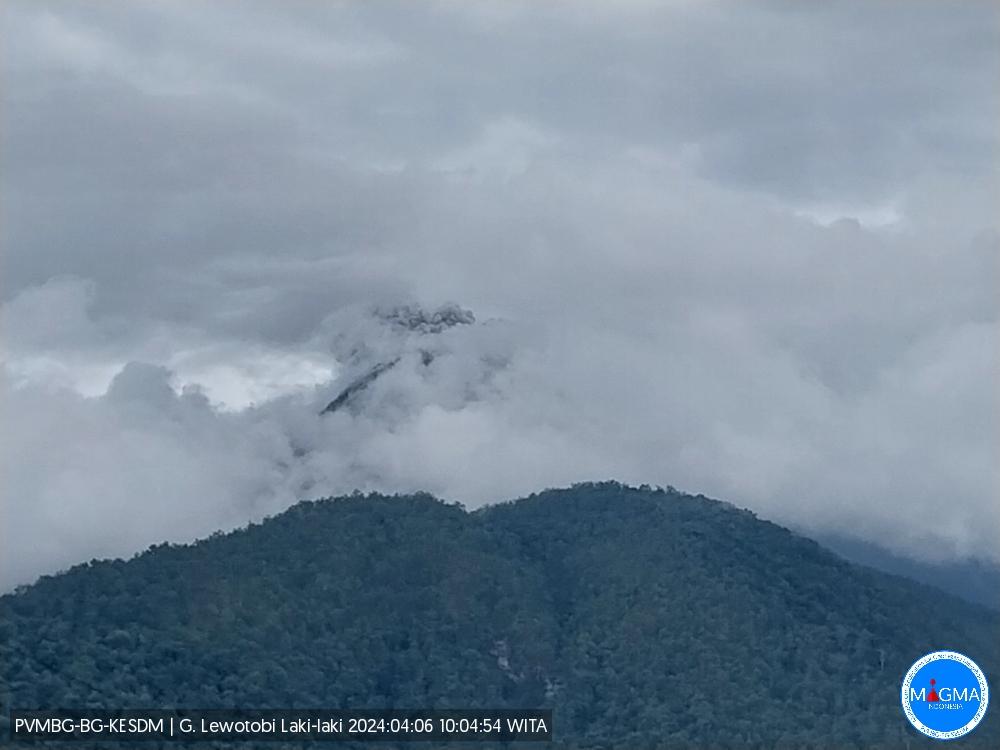
An eruption of Mount Lewotobi Laki occurred on Saturday April 6, 2024 at 10:02 WITA with the height of the ash column observed at ±200 m above the summit (±1784 m above sea level). The ash column was observed to be white to gray in color with moderate to thick intensity, oriented towards the North. This eruption was recorded on a seismograph with a maximum amplitude of 7.4 mm and a duration of 118 seconds.
Observation of seismicity
2 eruption/explosion earthquakes with an amplitude of 7.4 mm and a seismic duration of 95 to 118 seconds.
1 Avalanche earthquake with an amplitude of 2.9 mm and an earthquake duration of 87 seconds.
4 emission earthquakes with an amplitude of 1.4 to 7.4 mm and earthquake duration of 34 to 98 seconds.
3 harmonic tremors with an amplitude of 2.2 mm and an earthquake duration of 60 to 153 seconds.
1 Deep volcanic earthquake with an amplitude of 5.9 mm, duration of the earthquake 12 seconds.
1 local tectonic earthquake with an amplitude of 5.9 mm, and duration of the earthquake of 23 seconds.
3 deep tectonic earthquakes with an amplitude of 4.4 to 47.3 mm, earthquake duration 43 to 178 seconds.
RECOMMENDATION
1. Communities around Mount Lewotobi Laki and visitors/tourists do not carry out any activities within a radius of 2 km around the center of the eruption of Mount Lewotobi Laki and in the area of 3 km in the North-North direction. East and 5 km in the direction of the northeast sector.
2. The public should remain calm and follow the instructions of the regional government and not believe rumors whose origin is unclear.
Source et photo : Magma Indonésie
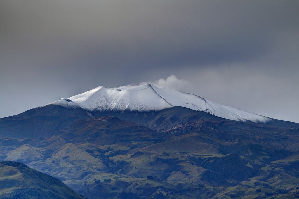
Ecuador : Sangay
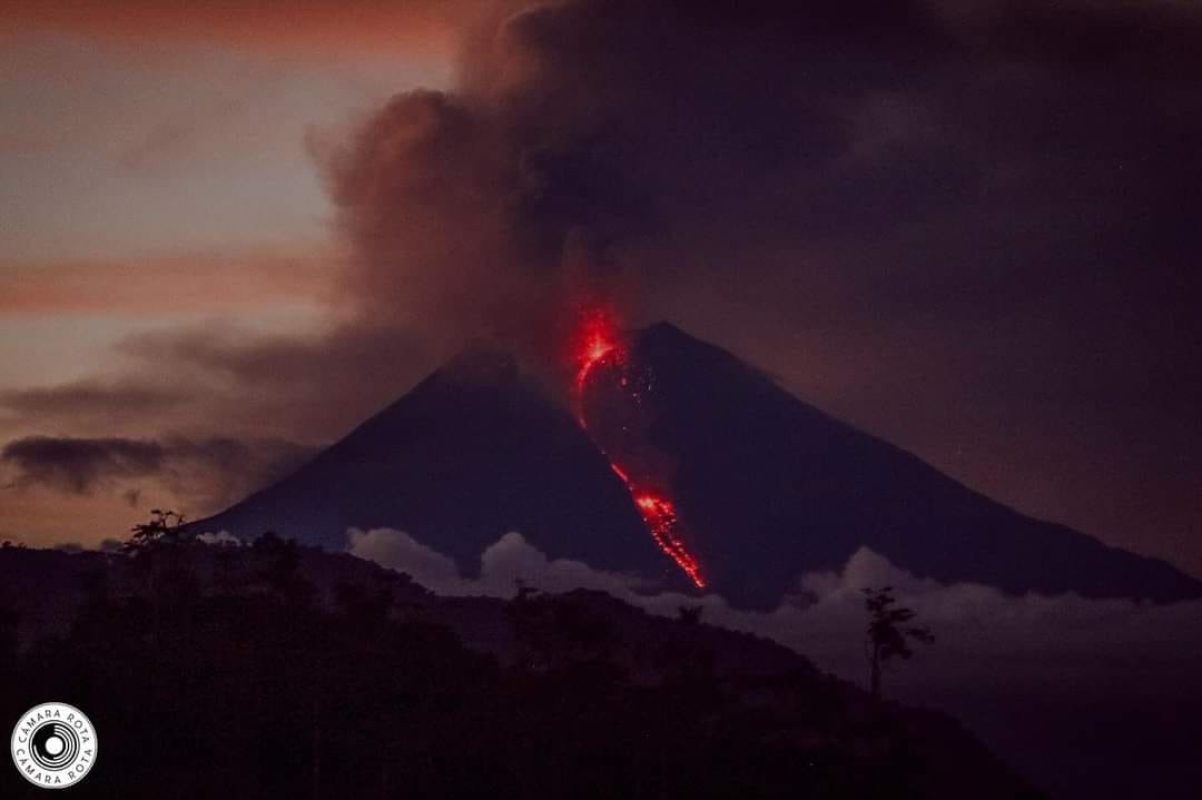
DAILY REPORT ON THE STATE OF THE SANGAY VOLCANO, Saturday April 6, 2024.
Information Geophysical Institute – EPN.
Surface activity level: High, Surface trend: No change
Internal activity level: High, Internal trend: No change
Seismicity: From April 5, 2024, 11:00 a.m. to April 6, 2024, 11:00 a.m.:
The number of seismic events recorded at the reference station over the past 24 hours is shown below. The level of seismic activity of the volcano remains high.
Explosion Event (EXP): 138
Precipitation/Lahars:
No rain was recorded in the region. **Heavy rains could remobilize accumulated material and generate flows of mud and debris that would flow down the volcano’s flanks and flow into adjacent rivers.
Emissions/ash column:
Due to weather conditions, it was not possible to observe gas or ash emissions using the surveillance camera system. The Washington VAAC agency also has not released reports on ash emissions over the past 24 hours.
Observation:
Since yesterday afternoon, thanks to the surveillance camera system, the volcano has remained completely cloudy most of the time.
Alert level: yellow
Source : IGEPN.
Photo : Cámara Rota
Chile , Laguna del Maule :
Special Report on Volcanic Activity (REAV), del Maule regions, Laguna del Maule volcanic complex, April 6, 2024, 04:48 local time (mainland Chile)
The National Geology and Mining Service of Chile (Sernageomin) announces the following PRELIMINARY information, obtained through the monitoring equipment of the National Volcanic Monitoring Network (RNVV), processed and analyzed at the Southern Andean Volcano Observatory (Ovdas):
In the context of an increase in volcano-tectonic seismicity (associated with the fracturing of rocks), originating from an event that occurred on Saturday April 6 at 1:28 a.m. (4:28 a.m. UTC) mentioned in the previous report, the monitoring stations installed near the Laguna del Maule volcanic complex have recorded for the last 3 hours, a total of 101 volcano-tectonic earthquakes.
The characteristics of the largest earthquake after its analysis are as follows:
ORIGINAL TIME: 02:41 local time (05:41 UTC)
LATITUDE: 36.115° S
LONGITUDE: 70.566° West
DEPTH: 7.5 km
LOCAL MAGNITUDE: 3.2 (ML)
Observation :
Currently, we are observing a decrease in volcano-tectonic seismicity, without ruling out the possibility of a reactivation of the seismic swarm.
The technical volcanic alert is maintained at YELLOW level.
Source : Sernageomin
Photo : auteur inconnu
Colombia , Puracé – Los Coconucos Volcanic Range :
Weekly activity bulletin: Puracé Volcano – Los Coconucos Volcanic Range
From the monitoring of the activity of the PURACE VOLCANO – LOS COCONUCOS VOLCANIC CHAIN, the MINISTRY OF MINES AND ENERGY, through the COLOMBIAN GEOLOGICAL SERVICE (SGC), reports that:
In the week between March 26 and April 1, 2024, seismic activity presented levels similar to those of previous weeks, both in seismic energy released and in the number of events. The fracture earthquakes recorded were mainly located on the southeastern flank of the Puracé volcano, with depths between 1 and 3 km and magnitudes less than 1.8 ML; while the earthquakes associated with the fluids were located in two areas: one under the crater of the volcano, at depths less than 500 m, and another to the South-East of it, at depths between 1.5 and 4.0 km.
During the period evaluated, deformations continued to be recorded between the Puracé and Curiquinga volcanoes. Likewise, the concentration of carbon dioxide (CO2) continued to oscillate and remains above reference values on this volcano. Likewise, the increase in the flow of sulfur dioxide (SO2) detected in previous weeks continued to be recorded.
Images obtained using installed cameras show that significant degassing of the volcanic system continues.
Other parameters measured for the assessment of volcanic activity showed no notable changes during the assessed period.
The alert status for volcanic activity remains at: YELLOW ALERT: ACTIVE VOLCANO WITH CHANGES IN THE BEHAVIOR OF THE BASE LEVEL OF MONITORED PARAMETERS AND OTHER MANIFESTATIONS.
Source : SGC
Photo : José M. Arboleda.
La Martinique , Montagne Pelée :
Weekly report, Paris Institute of Globe Physics / Martinique Volcanological and Seismological Observatory
Activity on Montagne Pelée, April 5, 2024 at 2:00 p.m. local time (GMT-4)
Volcanic activity increased this week with 26 earthquakes of volcanic origin observed.
Between March 29, 2024 at 4:00 p.m. (UT) and April 5, 2024 at 4:00 p.m. (UT), the OVSM recorded 26 very low energy volcano-tectonic earthquakes. These earthquakes were clearly identified as originating from one of the well-known seismically active zones at Montagne Pelée, located between 1.0 and 1.4 km depth below the summit of the volcano.
Surface seismicity of the volcano-tectonic type is associated with micro-fracturing in the volcanic edifice linked to the global reactivation of the volcano observed since the end of 2018.
No earthquake was felt by the population.
The previous week, the OVSM had recorded 28 earthquakes of volcanic origin. As of April 5, 2024 and during the last 4 weeks, the OVSM has therefore observed a total of 62 volcanic earthquakes, or an average of 15 to 16 earthquakes per week.
During phases of volcanic reactivation of volcanoes similar to Montagne Pelée, it is usual to observe seismic activity varying in intensity and frequency.
The alert level is currently YELLOW: vigilance.
Source : Direction de l’OVSM-IPGP.
Photo : Photopoesie