August 26 , 2023.
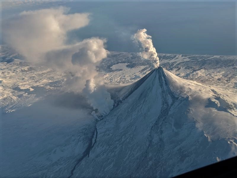
Alaska , Shishaldin :
AVO/USGS Volcanic Activity Notice
Current Volcano Alert Level: WATCH
Current Aviation Color Code: ORANGE
Issued: Friday, August 25, 2023, 11:36 AM AKDT
Source: Alaska Volcano Observatory
Location: N 54 deg 45 min W 163 deg 58 min
Elevation: 9373 ft (2857 m)
Area: Aleutians
Volcanic Activity Summary:
The level of unrest has increased at Shishaldin Volcano. Seismic tremor began to increase at around 03:00 this morning Alaska time (11:00 UTC) and is escalating. Elevated surface temperatures consistent with lava erupting at the summit are evident in the latest satellite data. Local infrasound data suggests low-level explosions are occurring. Based on previous eruption cycles over the past month, ash emissions are likely over the next few hours.

Issued: Friday, August 25, 2023, 12:04 PM AKDT
Volcanic Activity Summary:
An ash cloud from Shishaldin Volcano reaching 28,000 ft (8.5 km) has been reported by aircraft in the vicinity of the volcano. This follows a several-hour increase in seismic activity. In response, the Aviation Color Code is being raised to RED and the Volcano Alert Level is being raised to WARNING.
Based on previous eruption cycles, significant ash emissions are likely to continue for several hours. Pyroclastic and mudflows are likely on the immediate flanks of the volcano.
Issued: Friday, August 25, 2023, 5:32 PM AKDT
Volcanic Activity Summary:
Explosive eruptive activity is continuing at Shishaldin Volcano. An ash cloud rising to about 30,000 ft (9 km) above sea level and extending roughly 280 miles (450 km) northeast of the volcano is evident in satellite data. A SIGMET for this ash cloud has been issued. Seismic tremor increased this afternoon and peaked around 4:30 pm Alaska time (00:30 UTC). The tremor has since dropped but remains elevated.
Issued: Friday, August 25, 2023, 8:20 PM AKDT
Volcanic Activity Summary:
Explosive eruptive activity is continuing at Shishaldin Volcano. An ash cloud continues to be observed in satellite data at an altitude of 21,000 ft (6.4 km) above sea level moving towards the northeast. This is a decrease in altitude from earlier today. Seismic tremor decreased rapidly around 5:30 pm AKDT (0130 UTC) and is approaching levels observed prior to the onset of ash emissions.
Based on previous eruption cycles, it is likley that ash emissions are starting to decrease and may end over the next few hours. Pyroclastic and mudflows are likely on the immediate flanks of the volcano. Minor to trace amounts of ash fall are likely to the north of the volcano and in the water immediately offshore. No ash fall is expected in populated areas.
The National Weather Service is responsible for tracking the drifting ash cloud and SIGMETs have been issued throughout the day.
Shishaldin Volcano is monitored by local seismic and infrasound sensors, web cameras, and a telemetered geodetic network. In addition to the local monitoring network, AVO uses nearby geophysical networks, regional infrasound and lighting data, and satellite images to detect eruptions.
Source : AVO
Photos : Nick Enloe , Brekke, Matt.
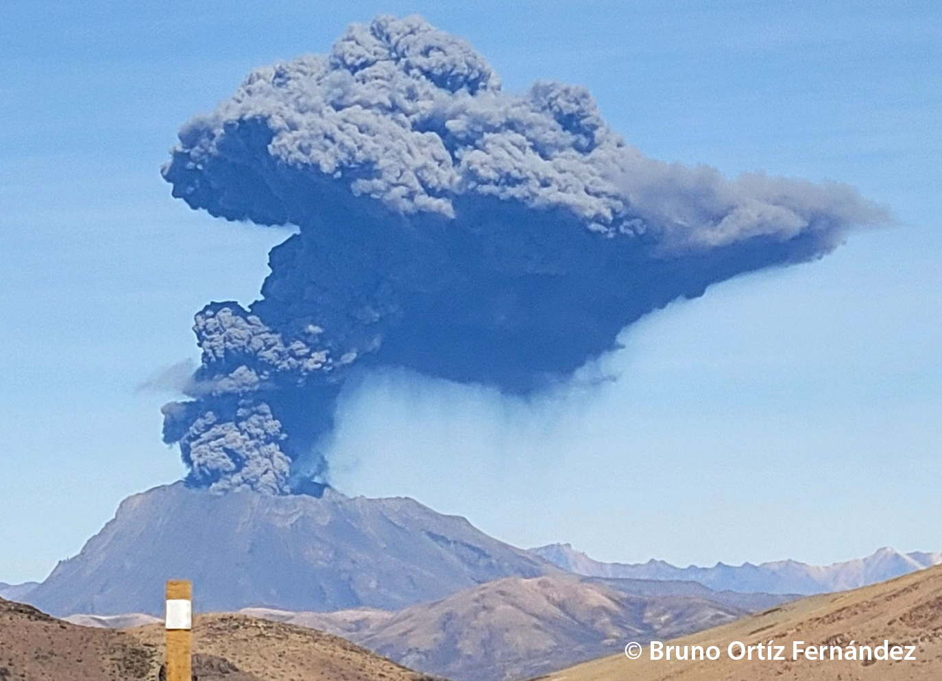
Peru , Ubinas :
UBINAS (GENERAL PROVINCE OF SÁNCHEZ CERRO) – IN ERUPTION PROCESS
o Eruptive process of moderate level.
o During the last 24 hours, gas emissions have been recorded with heights of up to 300 m above the summit of the volcano. Likewise, 371 earthquakes associated with rock fracturing processes inside the volcano and 58 seismic signals related to the movement of fluids and gases were recorded.
o According to the analysis of satellite images and the SENAMHI dispersion model, the dispersion of ashes and gases took place towards the West, North-West and North sectors, towards the districts of San Juan de Tarucani, Ubinas and their respective population centers in these sectors.
o The approximate radius affected by ashfall after today’s emissions is less than 5 km from the crater, i.e. within the volcano area
o Satellite systems did not detect any thermal anomalies on the surface of the crater.
o The monitoring of the deformation on the volcanic structure shows variations of less than 7 mm of displacement (slight tendency to swelling).
Conclusion:
The Ubinas volcano has developed an eruptive process of moderate levels, characterized by the recording of significant internal seismic activity and ash emissions. During the past 24 hours, gas emissions have been recorded up to 100 m above the summit of the volcano.
The population must remain attentive to possible ash falls and follow the recommendations made by the Civil Protection authorities.
Recommendation:
Stay tuned for vulcanological reports and bulletins issued by the IGP via CENVUL.
Current Volcanic Alert Level: Orange
Source : Cenvul.
Photo : Bruno Ortiz Fernandez.
Indonesia , Ili Lewotolok :
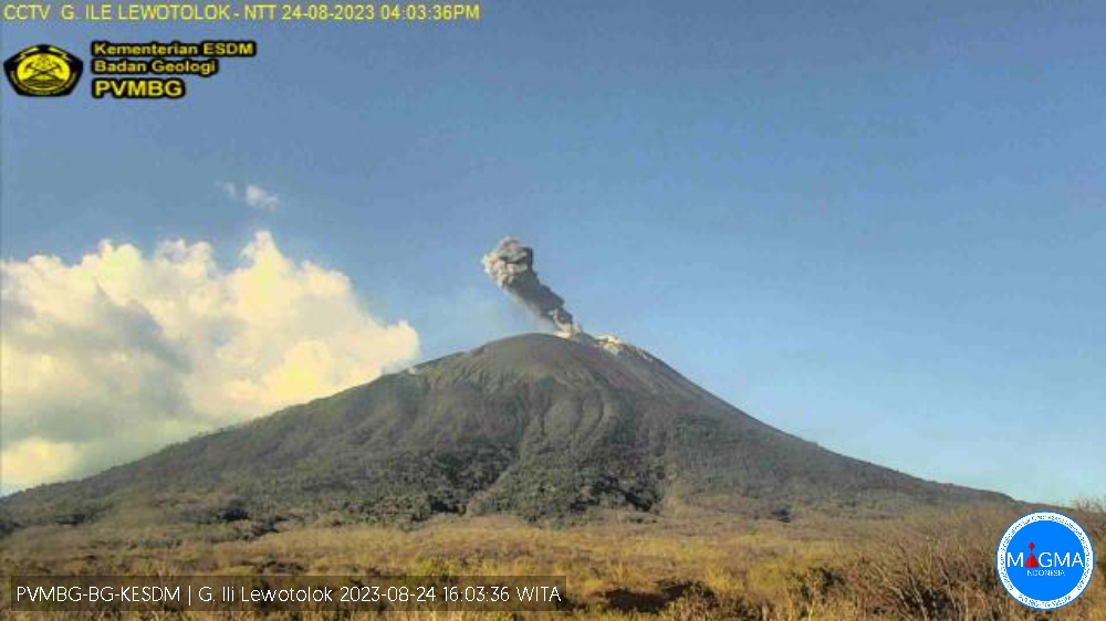
An eruption of G. Ili Lewotolok occurred on Thursday, August 24, 2023, at 4:03 p.m. WITA with the height of the ash column observed ± 700 m above the summit (± 2123 m above sea level) . The ash column was observed to be gray with moderate to thick intensity, oriented to the west. This eruption was recorded on a seismograph with a maximum amplitude of 33.5 mm and a duration of 87 seconds.
VOLCANO OBSERVATORY NOTICE FOR AVIATION – VONA
Issued : August 24 , 2023
Volcano : Ili Lewotolok (264230)
Current Aviation Colour Code : ORANGE
Previous Aviation Colour Code : orange
Source : Ili Lewotolok Volcano Observatory
Notice Number : 2023LEW047
Volcano Location : S 08 deg 16 min 19 sec E 123 deg 30 min 18 sec
Area : East Nusa Tenggara, Indonesia
Summit Elevation : 4554 FT (1423 M)
Volcanic Activity Summary :
Eruption with volcanic ash cloud at 08h03 UTC (16h03 local).
Volcanic Cloud Height :
Best estimate of ash-cloud top is around 6794 FT (2123 M) above sea level or 2240 FT (700 M) above summit. May be higher than what can be observed clearly. Source of height data: ground observer.
Other Volcanic Cloud Information :
Ash cloud moving to west. Volcanic ash is observed to be gray. The intensity of volcanic ash is observed from medium to thick.
Remarks :
Eruption recorded on seismogram with maximum amplitude 33.5 mm and maximum duration 87 second.
Source et photo : Magma Indonésie.
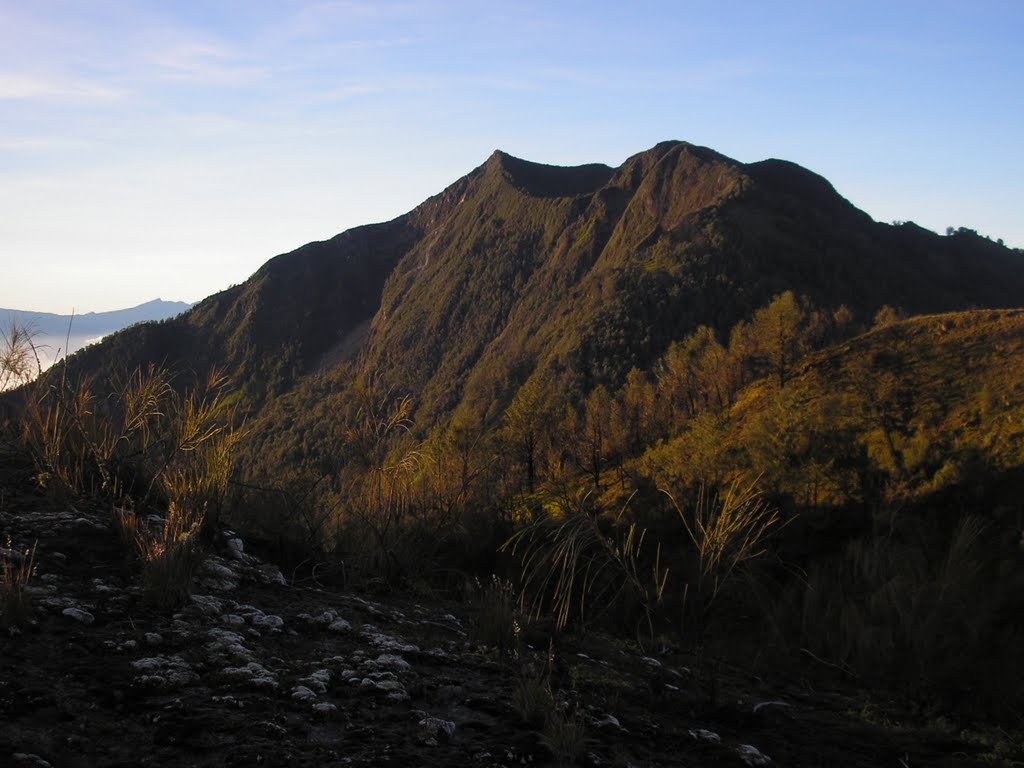
Indonesia , Arjuno Welirang :
PRESS RELEASE ON ARJUNO WELIRANG VOLCANO ACTIVITY.
The Arjuno Welirang volcano is a stratovolcano with a height of 3,339 meters. Administratively, this volcano is located on the border of Batu City, Malang Regency and Pasuruan Regency in East Java and is monitored by the Volcano Observation Post (PPGA) located at Deşa Sukoreno. The last eruption of the Arjuno Welirang volcano was recorded on August 15, 1952 for about 5 days with a VEI 2 scale. On August 22, 2023, an incandescence was observed at the top of Mount Arjuno Welirang.
Monitoring data:
Visual observations for the period January 1 to August 24, 2023 observed smoke billowing from the crater of G. Arjuno Welirang, which was white with low to moderate intensity, around 20 to 70 meters from the summit, and a silent glow was observed on August 22, 2023.
Instrumental monitoring using seismographs shows that seismicity is still dominated by emissions and tectonics and started recording intense volcanic earthquakes in early July, but the number of these earthquakes was still not significant.
Hotspots have not been recorded from visual satellite images.
Assessment:
According to visual monitoring from G. Arjuno’s monitoring post, there was no visible change. Visually, the smoke is white, although it is sometimes seen with thicker intensity than before. The seismic data recorded on the seismograph does not show a significant increase in seismicity, the seismicity is still fluctuating and is still dominated by emissions and tectonics.
However, the top of Mount Arjuno Welirang is covered in sulfur which is often mined by local residents. The glow of the incandescence observed on August 22, 2023 came from a fire in the sulfur pile and not from the magmatic activity of Mount Arjuno Welirang.
Conclusion
Based on the above, it can be concluded that the activity level of the Arjuno Welirang volcano has not increased and remains at level 1 (normal).
G. Arjuno Welirang’s activity level may be reassessed if there is a significant change in visual and instrumental activity.
Source : PVMBG
Photo : Daniel Quinn, Juillet 2010
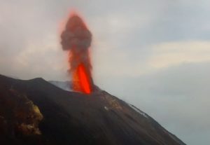
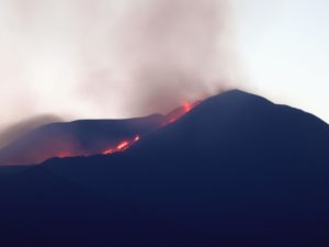
Ecuador , Reventador :
DAILY REPORT OF THE STATE OF THE REVENTADOR VOLCANO, Friday August 25, 2023.
Information Geophysical Institute – EPN.
Surface Activity Level: High, Surface Trend: Unchanged
Internal activity level: Moderate, Internal trend: No change
Seismicity: From August 24, 2023, 11:00 a.m. to August 25, 2023, 11:00 a.m.:
The following table shows the number of seismic events from the reference station over the past 24 hours.
Explosion (EXP) 12
Long Period (LP) 25
Transmit dither (TREMI) 15
Harmonic Tremor (TRARM) 2
Rains / Lahars:
There is no rain report. “In the event of heavy rains, these could remobilize the accumulated materials, generating mudslides and debris that would descend the flanks of the volcano and pour into the adjacent rivers.
Emission / Ash Column:
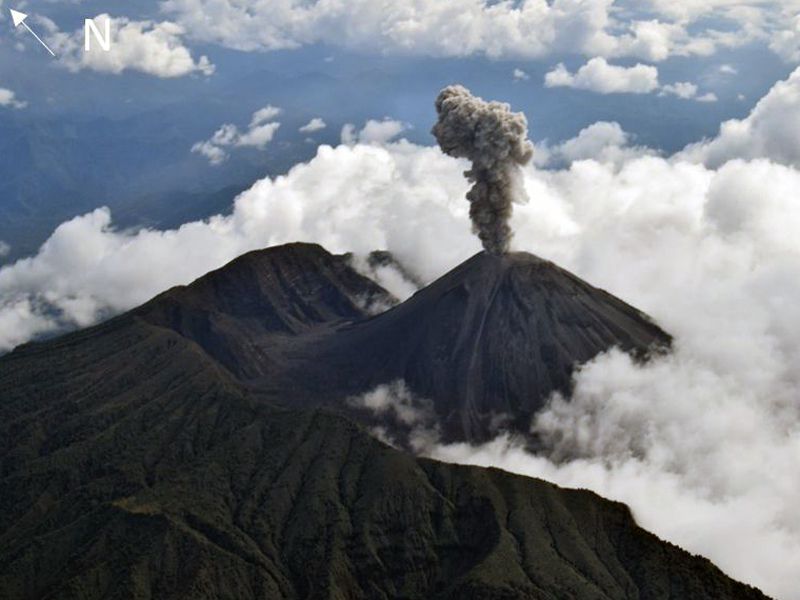
Yesterday afternoon and today morning, several gas and ash emissions were observed with heights of 800, 300, <500 and >700 meters above the level of the crater in the directions West, South-West, Southwest and Northwest respectively. The volcano had a W-VAAC alert.
Other Monitoring Parameters:
Neither FIRMS, nor MIROVA, nor WorldView registers thermal alerts during the last 24 hours.
Observation:
During the afternoon and night of yesterday and early morning today, the volcano was observed completely clear. On the other hand, in the night of yesterday, episodes of incandescence were recorded at the level of the crater with expulsion of material up to 300 meters above the level of the crater.
Alert level: Orange.
Source : IGEPN.
Photo : F-Naranjo , GVP.