December 22 , 2019.
Kamchatka , Sheveluch :
VOLCANO OBSERVATORY NOTICE FOR AVIATION (VONA).
Issued: December 22 , 2019.
Volcano: Sheveluch (CAVW #300270)
Current aviation colour code: ORANGE
Previous aviation colour code: orange
Source: KVERT
Notice Number: 2019-183
Volcano Location: N 56 deg 38 min E 161 deg 18 min
Area: Kamchatka, Russia
Summit Elevation: 10768.24 ft (3283 m), the dome elevation ~8200 ft (2500 m)
Explosions sent ash up to 10 km a.s.l. on 04 December, 2017, ash plume is extending to the northeast from the volcano.
Volcanic Activity Summary:
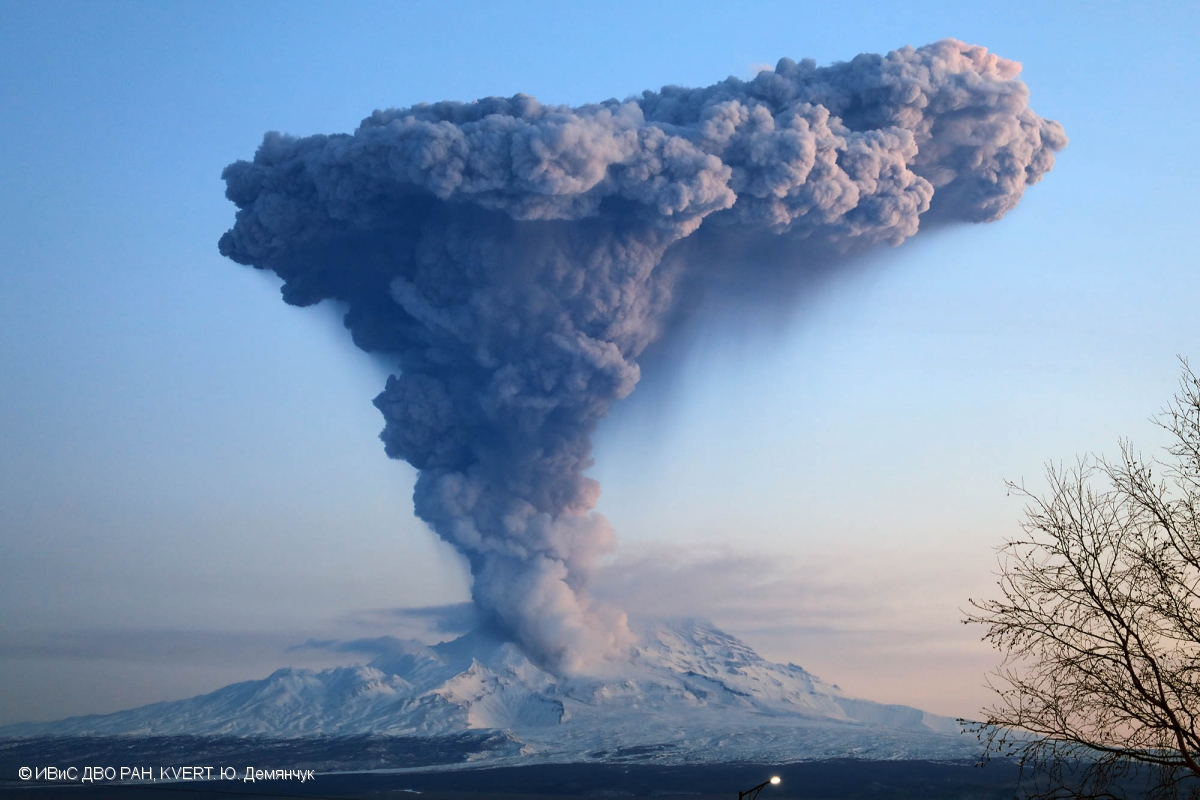
An activity of the volcano continues. Explosions sent ash up to 6.0-6.5 km a.s.l. near 23:50 UTC on December 21, according to Tokyo VAAC data. Satellite data by KVERT showed an ash cloud is drifting about 25 km to the east of the volcano.
Explosive-extrusive eruption of the volcano continues. Ash explosions up to 32,800-49,200 ft (10-15 km) a.s.l. could occur at any time. Ongoing activity could affect international and low-flying aircraft.
Volcanic cloud height:
19680-21320 ft (6000-6500 m) AMSL Time and method of ash plume/cloud height determination: 20191222/0030Z – Himawari-8
Other volcanic cloud information:
Distance of ash plume/cloud of the volcano: 16 mi (25 km)
Direction of drift of ash plume/cloud of the volcano: E / azimuth 80 deg
Time and method of ash plume/cloud determination: 20191222/0030Z – Himawari-8
Source : Kvert.
Photo : Yu. Demyanchuk, IVS FEB RAS, KVERT , 4/12/2017 .
Costa Rica , Rincon de la Vieja / Arenal / Poas / Turrialba :
Rincon de la Vieja volcano.
Guanacaste mountain range
10,831 ° N – 85,336 ° W
Altitude of the active crater: 1560 m s.n.m.
The seismic activity was maintained with the appearance of long-type signals (slightly greater than two tens) and a volcanotectonic signal, recorded at the stations closest to the volcano. Sporadic signs of spasmodic and sometimes harmonic tremors are observed.
It is recommended to stay away from the canals of rivers near the volcano in the event of an eruption, due to the possibility of primary lahars., As well as in the event of rain, as secondary lahars could be generated by the ash and materials accumulated in the upper parts of the volcano.
Arenal volcano.
Tilarán mountain range
10412 ° N – 84702 ° W
Altitude of the active crater: 1755 m s.n.m.
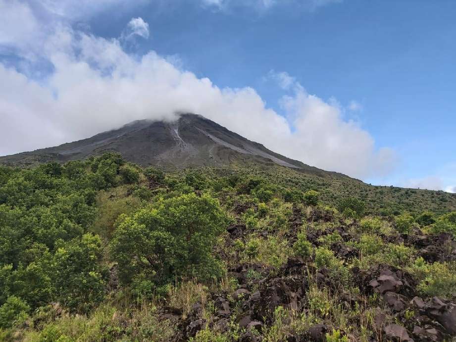
In this photo of the Arenal volcano, we observe the deposits of certain avalanches of debris on the western slope and part of a lava flow covered with vegetation.
Photograph of Minor Taylor from ICE.
The Arenal volcano maintained low seismic activity, characterized by volcano-tectonic events (a dozen), mainly recorded at the nearest station and a hybrid type signal recorded at several stations. No signal associated with an avalanche of debris was recorded.
On a clear day, small fumes of water vapor were observed due to the condensation and the remaining heat which still persists at the top of the main crater.
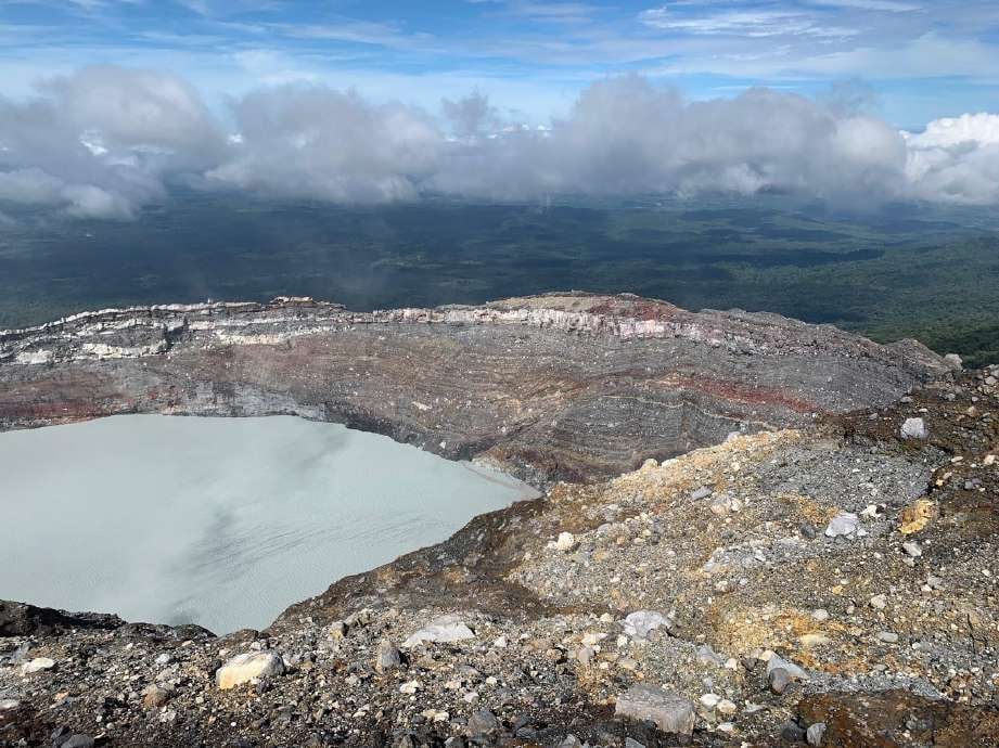
Poas volcano.
Central volcanic chain
10197 ° N – 84702 ° W
Altitude of the active crater: 2550 m s.n.m.
In this photograph of the Poás volcano, we observe the main crater of the Poás volcano seen from the West sector. In the upper central part of the image, the field of fumaroles is visible, which can be recognized by the yellowish color generated by the accumulation of sulfur. This photo was shared by park warden Martín Herrera Núñez.
The lagoon in the crater maintained its level compared to the previous week. The color of the water continues to be greenish. Evaporation processes continue to be intense and precipitation has decreased compared to the previous week. The field of fumaroles rich in sulfur in the Northeast sector maintains its expiration activity. From mouth A, the gas and water vapor outlet was observed almost continuously. Seismically, the low amplitude background tremor (2 to 4.5 Hz) was maintained, as well as the discrete events of LP type (long period) also of low amplitude. Visitors to Poás Volcano National Park are reminded that this site has protocols in case of an eruption. Depending on the type of activity, visits can be suspended or delayed. Tourists are asked to always be alert to any change in activity and to follow the instructions of the park wardens.
It is recommended to stay away from the canals of rivers near the volcano in the event of an eruption, due to the possibility of primary lahars, as well as in the event of rain, since secondary lahars could be generated by ash and materials accumulated in the upper parts of the volcano or by the overflow of the lagoon.
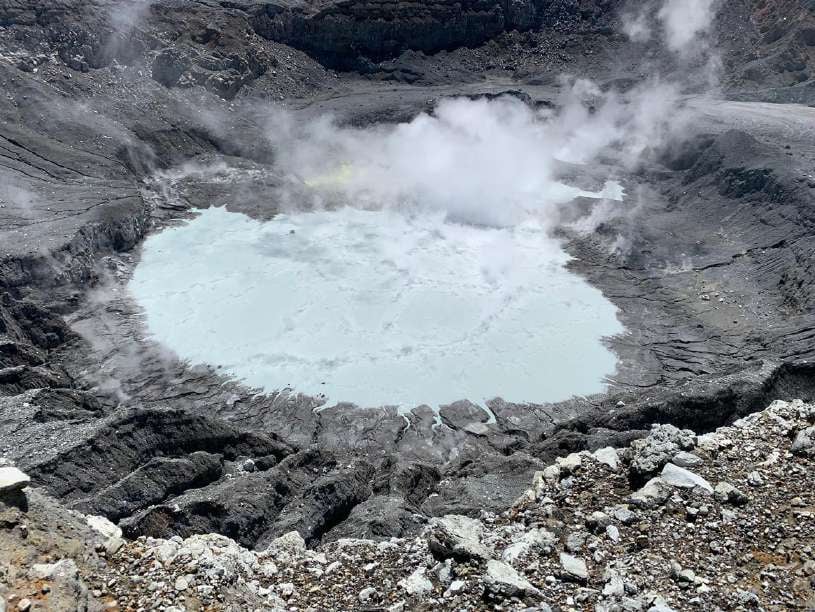
Turrialba volcano.
Central volcanic mountain range
10017 ° N – 83765 ° W
Altitude of the active crater: 3230 m asl
The Turrialba volcano presented a stable and low activity state. The water vapor and gas column dispersed mainly to the West and Southwest sectors. Seismic activity is low, dominated by low frequency discrete earthquakes. The presence of two lakes at the top of the volcano continues, with variations depending on the rain, while a third body of water forms for a few hours after the rains, but then disappears. The glow recorded by volcanic surveillance cameras in the active crater continues as intense as the previous week. No major change in seismicity was reported from the previous week.

This photograph of the Turrialba volcano was taken by members of the national seismological network on February 9, 2018 in the massif. One observes a turquoise green coloration in one of the lagoons. Credits: Dr. Guillaume Alvarado And Blas Sanchez
The public is reminded that the entrance to the Turrialba Volcano National Park, coinciding with a radius of 2 km around the active crater, is closed due to the activity of the volcano. Approaching the crater means very high risk activity.
Source : RSN.
Photos : Juan Carlos López / ICE. Minor Taylor / ICE. Martín Herrera Núñez . Dr. Guillaume Alvarado Et Blas Sanchez.
Indonesia , Karangetang :
Level of activity at level III (SIAGA). G. Karangetang (1,784 m above sea level) entered an eruption period since November 25, 2018. The last eruption occurred on November 29, 2019, resulting in an eruption column height of 100 m. The color of the gray column was observed in gray.
The volcano is clearly visible until it is covered with fog. The smoke from the crater is observed white with a low to moderate intensity about 100 meters above the summit. The weather is cloudy to rainy, light winds from the southeast. The temperature is around 26-29 ° C.
Incandescent projections rising from 10 to 25 m have been observed in the main crater. A lava flow from the main crater to Kali Nanitu, Kali Sense, Kali Pangi was observed with a length of 1000 to 1500 m, sometimes observed in the direction of Kali Beha Barat and Kali Batang over 800 to 1500 m . The smoke from crater 2 was observed to be white and rising from 25 to 50 m. Incandescent projections 10 m high have been observed.
According to the seismographs of December 21, 2019, it was recorded:
67 avalanche earthquake
4 earthquake explosions
4 harmonic earthquakes
2 Hybrid / Multiple Phase earthquakes
2 shallow volcanic earthquakes
9 distant tectonic earthquakes
Continuous tremor, amplitude 0.5-3 mm (dominant value 2 mm).

Recommendation:
The community and visitors / tourists should not approach, climb or move around in the danger forecast area, which is a 2.5 km radius around the summit of Kawah Dua (North crater) and from the main crater (South) and a sectoral expansion zone of the Kawah Dua of 4 km to the North and from the main crater up to 3 km to the West.
It is recommended that the communities around Mount Karangetang prepare masks to cover the nose and mouth, in order to anticipate the potential danger of respiratory problems in the event of ash rain.
The communities living around the rivers that come from the summit of Mount Karangetang must increase their preparation for the potential threat of lahars and flash floods that can descend to the coast.
VONA: The last YELLOW color code was sent on 25 November 2018 at 13:32, linked to the emission of volcanic ash at an altitude of about 2284 m above sea level or about 500 m above the summit, the wind was blowing east.
Source : PVMBG.
Photo : visit siau island , mai 2019.
Mexico , Popocatepetl :
December 21, 11:00 a.m. (December 21, 5:00 p.m. GMT)
According to the monitoring systems of the Popocatepetl volcano, 162 exhalations have been identified accompanied by water vapor, volcanic gases and a low ash content. In addition, 38 minutes of tremors were recorded, a M 1.4 volcano-tectonic earthquake yesterday at 12:20 p.m. and an explosion at 5:37 a.m. today.
From the early hours of the morning, a constant emission of volcanic gases with sometimes small amounts of ash were observed, which are preferentially dispersed towards the East-North-East due to the strong prevailing winds in the region.
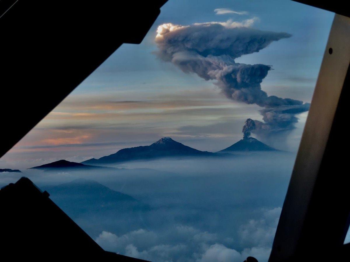
CENAPRED urges NOT to APPROACH the volcano and especially the crater, because of the danger of falling ballistic fragments, and in case of heavy rain, to stay far from the bottom of the ravines because of the danger of mudslides and debris .
The Popocatépetl volcanic traffic light is in YELLOW PHASE 2.
In collaboration with Webcams de México, four high resolution cameras have been installed to monitor the Popocatépetl and Fuego de Colima volcanoes.
In order to improve the visual monitoring of Popocatépetl and Fuego de Colima volcanoes, the National Center for Disaster Prevention (CENAPRED), under the National Coordination for Civil Protection (CNPC) of the Ministry of Security and Citizen Protection (SSPC ), installed, in collaboration with México’s Webcams, four high resolution (HD) cameras to obtain details on the ash emissions and the fragments expelled from these volcanoes as part of their eruptive activity.
Source : Cenapred .
Photo : pilote Jaime del Río , 18/06/2019.