
November 09 , 2023.
Iceland , Reykjanes Peninsula:
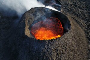
Approximately 1200 earthquakes the last 24 hours. Uplift continues at a similar pace according to Satellite and GPS data. Updated 8. November at 2:40pm
Approximately 1200 earthquakes have been measured in the last 24 hours, most of them in the area between Þorbjörn and Sýlingafell, similar to the day before. The largest earthquake was M3.4 at 12:31am last night, just south of Þorbjörn. The seismic activity continues at the same depth as before. It is likely that seismic activity will continue, and be episodic in intensity, while magma accumulation is ongoing.
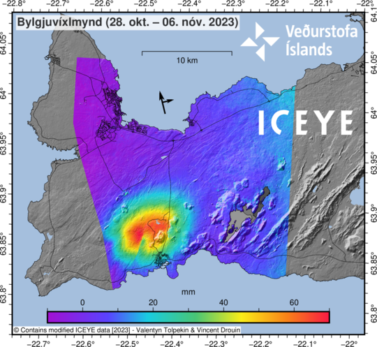
Interferogram (InSAR) for the period 28th of October – 6th of November shows that deformation in that period is around 7 cm. SW of Mt. Þorbjörn is an offset in the deformation signal caused by fault movements by earthquakes.
Uplift continues at a similar rate as before according to Satellite and GNSS data. Interferogram (InSAR) for the period 28th of October – 6th of November showing near-vertical motion confirms this, but it also shows offsets due to fault movements associated with the seismic activity. Updated models based on the same data estimate that magma continues to accumulate in a horizontal sill at a depth of about 5 km and since the beginning of the inflation event (October 27th) the average inflow is estimated about 5 m3/s (uncertainty is ±2 m3/s)
After midnight a intensive swarm near Mt. Þorbjörn and Sýlingafell started with an earthquake of M3.9 at 00:02 am. At 00:13 am another event of M4.2 was detected and the largest one occurred at 00:46 of M5.0. About 400 eqs. have been detected and 18 over M3.0, the last one at 02:56 am of M4.3. The earthquakes were felt in all Southwest Iceland.
Source et photo : IMO
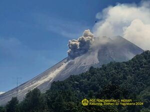
Indonesia , Dukono :
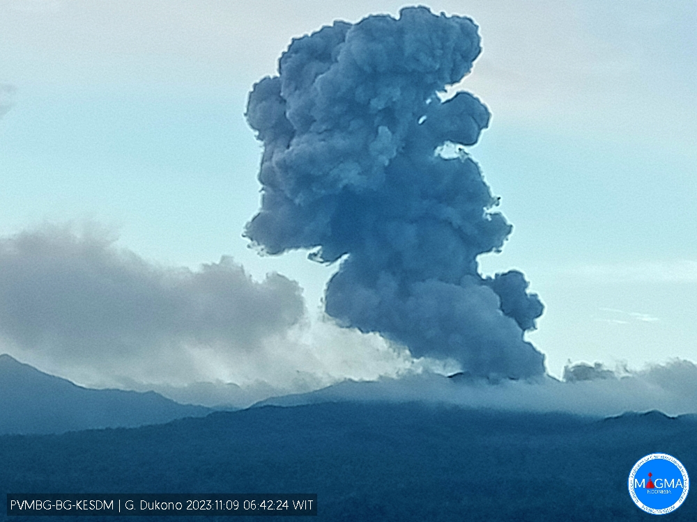
An eruption of Mount Dukono occurred on Thursday, November 9, 2023, at 06:42 WIT. The height of the eruptive column was observed to be ±1,000 m above the peak (±2,087 m above sea level). The ash column was observed to be white to gray in color with thick intensity, oriented towards the East. At the time of writing, the eruption was still ongoing.
VOLCANO OBSERVATORY NOTICE FOR AVIATION – VONA
Issued : November 08 , 2023
Volcano : Dukono (268010)
Current Aviation Colour Code : ORANGE
Previous Aviation Colour Code : orange
Source : Dukono Volcano Observatory
Notice Number : 2023DUK014
Volcano Location : N 01 deg 41 min 35 sec E 127 deg 53 min 38 sec
Area : North Maluku, Indonesia
Summit Elevation : 3933 FT (1229 M)
Volcanic Activity Summary :
Eruption with volcanic ash cloud at 21h42 UTC (06h42 local).
Volcanic Cloud Height :
Best estimate of ash-cloud top is around 7133 FT (2229 M) above sea level or 3200 FT (1000 M) above summit. May be higher than what can be observed clearly. Source of height data: ground observer.
Other Volcanic Cloud Information :
Ash cloud moving to east. Volcanic ash is observed to be white to gray. The intensity of volcanic ash is observed to be thick.
Remarks :
Eruption and ash emission is continuing.
Source et photo : Magma Indonésie.
Chile , Laguna del Maule :
Seismology
The seismological activity of the period was characterized by the recording of:
569 seismic events of type VT, associated with the fracturing of rocks (Volcano-Tectonics). The most energetic earthquake had a Local Magnitude (ML) value equal to 2.6, located 3.6 km east-southeast of the lagoon, at a depth of 9.6 km compared to the average height of the lagoon.
2 LP type seismic events, associated with fluid dynamics inside the volcanic system (Long Period). The size of the largest earthquake evaluated from the Reduced Displacement (RD) parameter was equal to 1.1 cm2.
Fluid geochemistry
No anomalies have been reported in the emissions of sulfur dioxide (SO2) into the atmosphere in the area near the volcanic complex, according to data published by the Tropospheric Monitoring Instrument (TROPOMI) and the Ozone Monitoring Instrument (OMI) .
Geodesy
From the 2 continuous GNSS stations operating on the volcanic complex, we observe that the inflationary process continues. The relative vertical deformation rate between the two stations for this period is 0.5 cm/month, lower than the previous period, considered moderate. On the other hand, from Sentinel-1 satellite images and the use of radar interferometry, the elevation of the volcanic complex area is partially observed, without substantial changes compared to what was observed during previous periods.
During this period, the volcanic complex continues with an obvious generation of seismic activity, in particular volcano-tectonic events, whose locations are distributed in the two most recurrent sources (Southwest and East sectors, relative to the center of the lagoon). At the same time, the process of cortical deformation remains active with uplift rates within the historically recorded average. These conditions allow us to deduce that the volcanic system is still above its basic threshold, therefore, the technical alert is maintained at YELLOW and a radius of possible impact by volcanic dangers of 2 km around the zone d maximum CO2 emission.
YELLOW TECHNICAL ALERT: Changes in the behavior of volcanic activity
Source : Sernageomin
Photo : OAVV
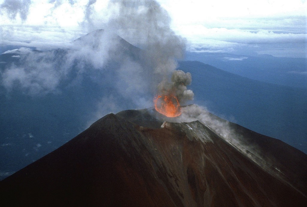
Japan , Iwo-Jima :
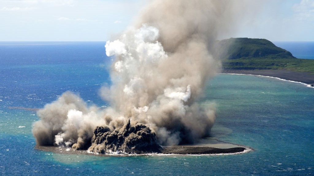
The eruption at Ioto (Iwo-jima), at a vent located about 1 km off the SE coast of Okinahama, continued during 1-3 November. A 2 November Sentinel satellite images showed a thermal anomaly at the SE end of the island which was elongated to the NNW-SSE. A white plume drifted about 400 m WSW. During an overflight on 3 November observers photographed the island and noted that a 169-m-high cone had formed at the SSE end according to news sources. Explosions occurred about every one minute that ejected dark material and incandescent material about 800 m above the vent. Floating, brown-colored pumice was present in the water around the island.
Ioto in the central Volcano Islands portion of the Izu-Bonin-Mariana arc lies within a 9-km-wide submarine caldera. Ioto, Iwojima, and Iojima are among many transliterations of the name. The volcano is also known as Ogasawara-Iojima to distinguish it from several other « Sulfur Island » volcanoes in Japan. The triangular, low-elevation, 8-km-long island narrows toward its SW tip and has produced trachyandesitic and trachytic rocks that are more alkalic than those of other volcanoes in this arc. The island has undergone uplift for at least the past 700 years, accompanying resurgent doming of the caldera; a shoreline landed upon by Captain Cook’s surveying crew in 1779 is now 40 m above sea level. The Motoyama plateau on the NE half of the island consists of submarine tuffs overlain by coral deposits and forms the island’s high point. Many fumaroles are oriented along a NE-SW zone cutting through Motoyama. Numerous recorded phreatic eruptions, many from vents on the W and NW sides of the island, have accompanied the uplift.
Source : GVP
Photo : Asahi Shimbun.
Papua New Guinea , Ulawun :
Rabaul Volcano Observatory (RVO) reported that diffuse white plumes rose from Ulawun’s summit crater on 1 November. A low booming noise was heard at 19h45. Minor crater incandescence began to be visible later that day at around 21h00 and was observed until sunrise. White emissions were visible early on 2 November but by the afternoon clouds of gray-to-brown ash were occasionally observed when weather permitted observations. Crater incandescence was again visible at nightfall but was more intense than the previous night and remained visible until sunrise. Seismicity was dominated by low-level volcanic tremor. Small, low-frequency earthquakes occurring at long intervals began to be recorded at some point before 23h00 on 1 November; an increase in both magnitude and frequency occurred after 23h00 and the signal again intensified after 08h00 on 2 November. Seismicity slightly declined around 08h00 on 3 November and remained at those levels at least through noon. The Alert Level remained at Stage 2 (on the four-level scale).
The symmetrical basaltic-to-andesitic Ulawun stratovolcano is the highest volcano of the Bismarck arc, and one of Papua New Guinea’s most frequently active. The volcano, also known as the Father, rises above the N coast of the island of New Britain across a low saddle NE of Bamus volcano, the South Son. The upper 1,000 m is unvegetated. A prominent E-W escarpment on the south may be the result of large-scale slumping. Satellitic cones occupy the NW and E flanks. A steep-walled valley cuts the NW side, and a flank lava-flow complex lies to the south of this valley. Historical eruptions date back to the beginning of the 18th century. Twentieth-century eruptions were mildly explosive until 1967, but after 1970 several larger eruptions produced lava flows and basaltic pyroclastic flows, greatly modifying the summit crater.
Source: Rabaul Volcano Observatory (RVO) , GVP.
Photo : James Mori, Disaster Prevention Research Institute, Kyoto University.
No comment yet, add your voice below!