October 26 , 2023.
Colombia , Puracé :
Popayan, October 25, 2023, 3:20 p.m.
From the monitoring of the activity of the PURACE VOLCANO, the MINISTRY OF MINES AND ENERGY through the COLOMBIAN GEOLOGICAL SERVICE (SGC) reports that:
Today, the number of earthquakes associated with the fracturing of rocks inside the volcano has increased noticeably, although at the time of publishing this statement they do not exhibit high levels of seismic energy. The maximum magnitude reached is 1.0. The earthquakes are located towards the South-East of the crater of the Puracé volcano, between the volcanic edifices of Puracé and Piocollo, at depths of between 1 and 4 kilometers. Until the release of this bulletin, this seismicity continues to be recorded.
In addition, the images obtained using the installed cameras show greater degassing of the volcanic system, with emissions of water vapor and gas into the atmosphere.
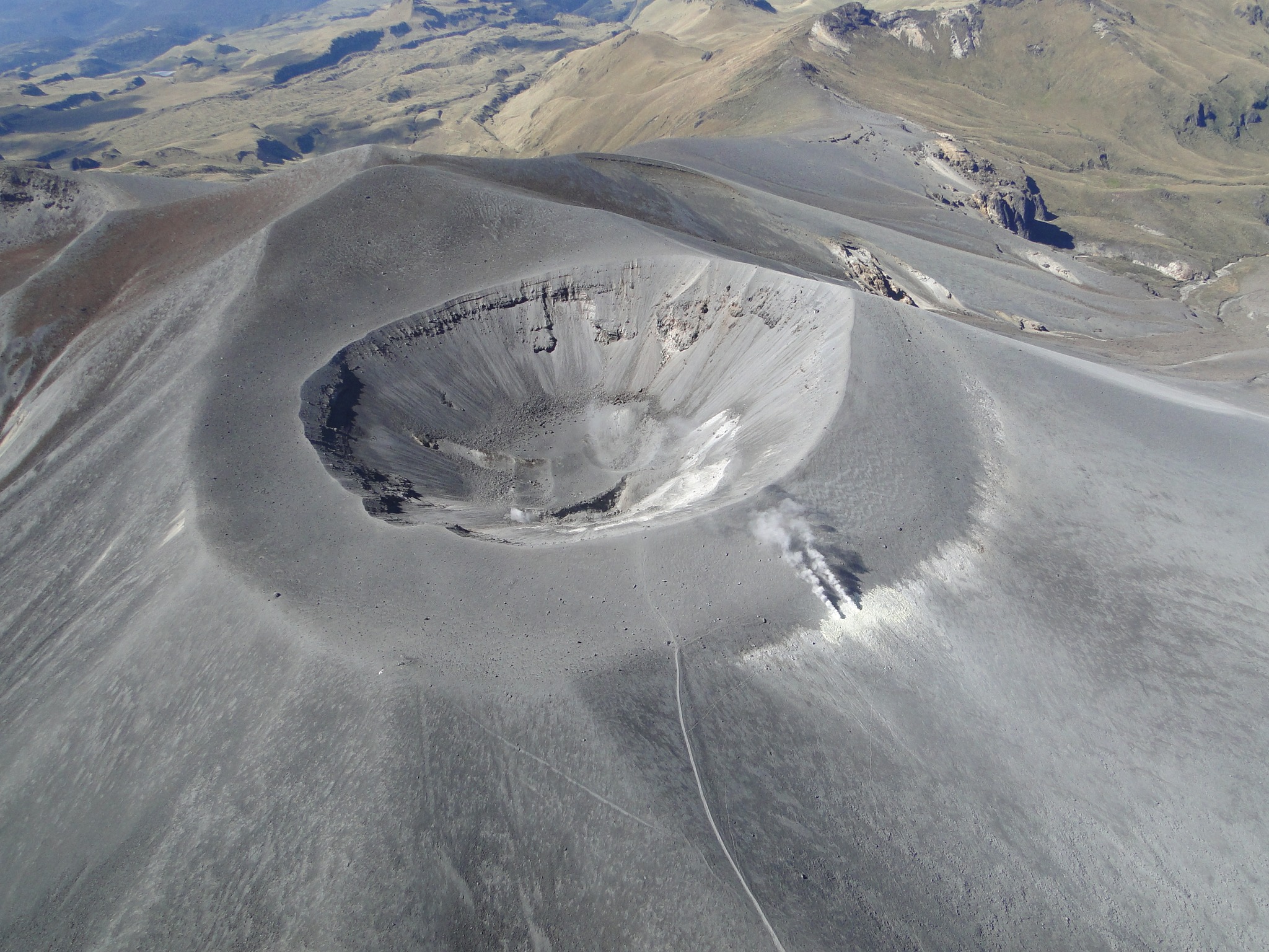
Gas measurements do not show variations in sulfur dioxide (SO2) values, but high carbon dioxide (CO2) values persist compared to what was recorded in the first half of 2023. On the other hand, thanks to measurements on the site, it was possible to detect low energy thermal anomalies between 30 and 150°C towards the bottom, the edge and the exterior of the crater (lateral fumarole), values which exceed those detected between 2018 and 2022 .
The other parameters monitored, such as deformation or electromagnetism, did not show significant variations.
Volcano alert status remains at YELLOW: Active volcano with changes in baseline behavior of monitored parameters and other manifestations.
Source et photo : SGC.
Ethiopia , Erta – Ale :
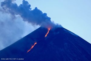
An eruption at Erta Ale continued during 5-20 October based on satellite data. Four thermal anomalies were located in the N and S pit craters, aligned in a NW-SE direction, based on a 5 October image. The northernmost anomaly in the N pit crater, was relatively weak. The other three, one located at the SE rim of the N pit crater and two in the S pit crater, were brighter and likely represented spatter cones. These three anomalies were more intense in a 10 October image. An image on 15 October showed lava flows likely coming from the two cones in the S pit crater traveling SE, SSE, NE, and SW. Minor, linear anomalies to the N of the cone on the SE rim of the N pit crater likely represented lava flows. The flows had cooled by 20 October.
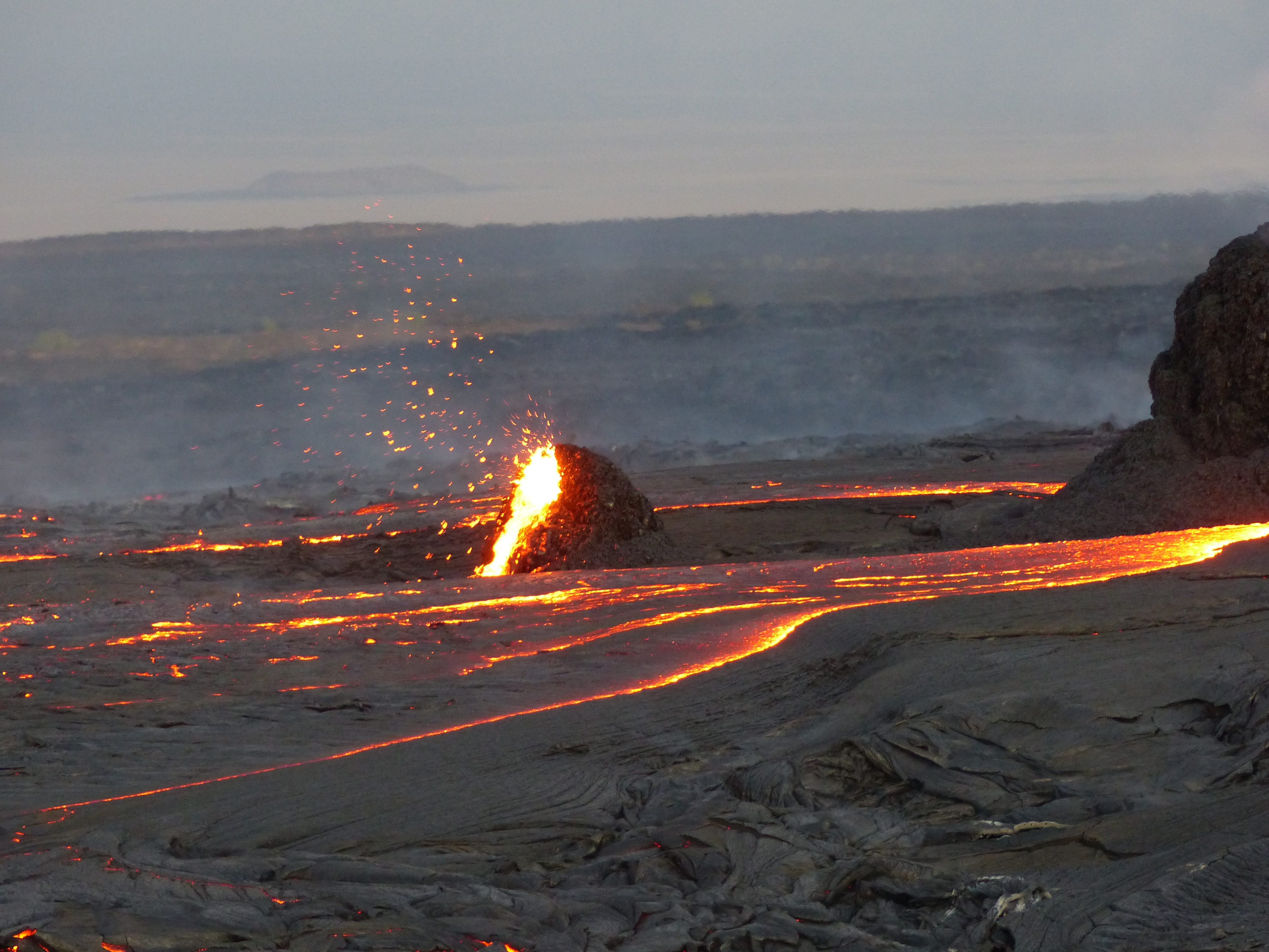
The Erta Ale basaltic shield volcano in Ethiopia has a 50-km-wide edifice that rises more than 600 m from below sea level in the Danakil depression. The volcano includes a 0.7 x 1.6 km summit crater hosting steep-sided pit craters. Another larger 1.8 x 3.1 km wide depression elongated parallel to the trend of the Erta Ale range is located SE of the summit and is bounded by curvilinear fault scarps on the SE side. Basaltic lava flows from these fissures have poured into the caldera and locally overflowed its rim. The summit caldera usually also holds at least one long-term lava lake that has been active since at least 1967, and possibly since 1906. Recent fissure eruptions have occurred on the N flank.
Source : Sentinel Hub , GVP
Photo : G Vitton / Le Chaudron de Vulcain
Iceland , Reykjanes Peninsula :
A seismic swarm started north of Grindavík last night . No evidence of magmatic intrusion around Þorbjörn and Grindavík . 25.10.2023
Last night an intense earthquake swarm started near Svartsengi, north of Grindavík. Over 1000 earthquakes have been detected there since midnight and the swarm is still ongoing. The largest earthquakes detected are M3.9 at 5:35 UTC and M4.5 at 8:18 UTC. Both of those earthquakes originated at around 5 km depth. Latest deformation data collected from several stations around the Þorbjörn/Grindavík area do not show significant changes correlated with the ongoing seismic activity.
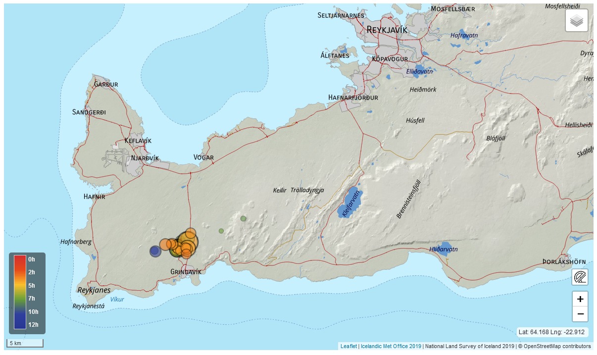
Reviewed earthquake locations from midnight to noon on the 25th of October 2023
In light of the data currently available, this seismicity is interpreted to be likely triggered by the stress changes related to previous intrusive activity on the peninsula. There are currently no indications of magma migration beneath the Þorbjörn/Grindavík area, but the situation might change anytime, and it might evolve over a short time from hours to days. As reported in September a magmatic intrusion is currently ongoing beneath Fagradalsfjall.
Staff of IMO continues to monitor the area closely and interpret newest data as it becomes available.
Uncertainty level of Department of Civil Protection has been declared due to this seismic swarm
Source : IMO
Colombia , Nevado del Ruiz :
Manizales, October 24, 2023 5:55 p.m.
Weekly bulletin on the activity of the Nevado del Ruiz volcano
From the monitoring of the activity of the NEVADO DEL RUIZ VOLCANO, the MINISTRY OF MINES AND ENERGY through the COLOMBIAN GEOLOGICAL SERVICE (SGC) reports that:
During the week of October 17-23, 2023, the volcano showed low to slightly moderate levels of activity, although instability in its behavior persists. Compared to the previous week, the main variations in the parameters monitored were:
– Seismic activity associated with the fracturing of rocks inside the volcanic edifice increased the seismic energy released and slightly decreased the number of recorded earthquakes. The earthquakes were located mainly in the East-Southeast sector of the volcano and, to a lesser extent, in the South-West sector and in the Arenas crater, up to maximum distances of 13 km from the crater. The depth range of the earthquakes varied between less than 1 and 7 km from the volcano summit.

The maximum magnitudes of the week were 3.0 and 3.2, corresponding to the earthquakes recorded on October 21 at 10:14 p.m. and October 22 at 8:37 a.m. These earthquakes, reported as felt in the municipality of Murillo (department of Tolima), occurred during an increase in seismicity recorded on the aforementioned days. Also, on October 21, seismicity was recorded linked to the activity of the lava dome located at the bottom of the crater.
– Seismicity linked to fluid dynamics through volcanic conduits has increased in the number of earthquakes recorded and in the seismic energy released. Most of these seismic signals had low and sometimes moderate energy levels. Thanks to the cameras used to monitor the volcano, several pulsatile emissions of ash and gas into the atmosphere or changes in the relative temperature of the emitted material have been confirmed, associated with this type of signals.
– The emission of water vapor and gas into the atmosphere continued at the volcano. Sulfur dioxide (SO2) outgassing rates were variable and showed a slight decreasing trend. This is perhaps due to the atmospheric conditions (cloudiness, wind direction and speed) which did not favor measurements in the area. The maximum height of the gas and ash column was 1,500 m and 1,600 m vertically and dispersed, respectively (these values were measured at the summit of the volcano, on October 17). The direction of dispersion of the column was variable with a tendency towards the North-West, North-North-East and South-West of the volcano.
Source et photo : SGC.
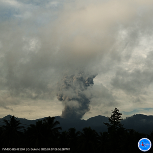
Japan , Sakurajima :
JMA reported ongoing activity at Minamidake Crater (Aira Caldera’s Sakurajima volcano) during 16-23 October, with incandescence at the crater observed nightly. Sulfur dioxide emissions were extremely high, averaging 4,200 tons per day on 16 October. During the week, there were a total of 11 eruptive events and 20 explosions, with a daily average of 1-5 explosions recorded during 16-21 October. Ash plumes rose as high as 3.6 km above the crater rim and drifted E, SE, and S, and large blocks were ejected as far as 1.2 km from the crater rim. A period of inflation began at around 0600 on 21 October, but ceased following an eruptive event during 0346-0430 on 24 October; the event produced an ash plume that rose 2.3 km above the crater rim and ejected large blocks 1.2 km. The Alert Level remained at 3 (on a 5-level scale), and the public was warned to stay 2 km away from both craters.

The Aira caldera in the northern half of Kagoshima Bay contains the post-caldera Sakurajima volcano, one of Japan’s most active. Eruption of the voluminous Ito pyroclastic flow accompanied formation of the 17 x 23 km caldera about 22,000 years ago. The smaller Wakamiko caldera was formed during the early Holocene in the NE corner of the caldera, along with several post-caldera cones. The construction of Sakurajima began about 13,000 years ago on the southern rim and built an island that was joined to the Osumi Peninsula during the major explosive and effusive eruption of 1914. Activity at the Kitadake summit cone ended about 4,850 years ago, after which eruptions took place at Minamidake. Frequent eruptions since the 8th century have deposited ash on the city of Kagoshima, located across Kagoshima Bay only 8 km from the summit. The largest recorded eruption took place during 1471-76.
Source : Japan Meteorological Agency (JMA) , GVP.
Photo : Webcam