September 06 , 2023.
Italy / Sicily , Etna :
WEEKLY BULLETIN, from August 28, 2023 to September 3, 2023. (issue date September 5, 2023)
SUMMARY STATEMENT OF ACTIVITY
In light of the monitoring data, it appears:
1) VOLCANOLOGICAL OBSERVATIONS: Degassing activity from the summit craters, in particular from the Bocca Nuova (BN) and South-East (CSE) craters.
2) SEISMOLOGY: Increase in the occurrence rate of fracturing earthquakes. Stationarity of volcanic tremor parameters.
3) INFRASOUND: Underestimated event occurrence rate during the first four days of the week.
The rest of the week, the occurrence rate is comparable to that of the previous week.
4) GROUND DEFORMATIONS: No significant variation is detected in the time series of the ground deformation monitoring stations.
5) GEOCHEMISTRY: low to medium level SO2 flux
Soil CO2 flux decreasing to low values.
There is no update on the helium isotope ratio.
The partial pressure of dissolved CO2 does not show significant variations.
6) SATELLITE OBSERVATIONS: Thermal activity observed by satellite was generally weak with rare and isolated anomalies of moderate level.
7) OTHER OBSERVATIONS: Processing of drone images from September 3 shows the presence of a hot fracture on the western flank of the Southeast crater (CSE).
VOLCANOLOGICAL OBSERVATIONS
During the reference week, monitoring of the activity of Etna was carried out through the network of surveillance cameras of the INGV – Osservatorio Etneo (INGV-OE), with the support of observations on the terrain carried out during certain inspections carried out by INGV-OE staff in the summit area.
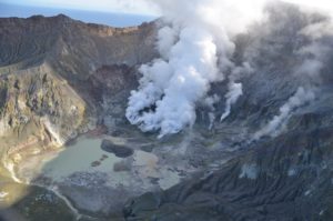
During the week, the activity of the summit craters of Etna was characterized by a variable regime of degassing of the summit craters, mainly affecting the craters of Bocca Nuova (BN) and the South-East Crater (CSE) which remained essentially unchanged from what was described in the previous week’s bulletin. In particular, the Bocca Nuova crater was characterized by intense, continuous and pulsed degassing, accompanied by explosions and nighttime glows, both from the collapse crater BN-1 and from the new pit crater which is formed from the second half of July 2023.
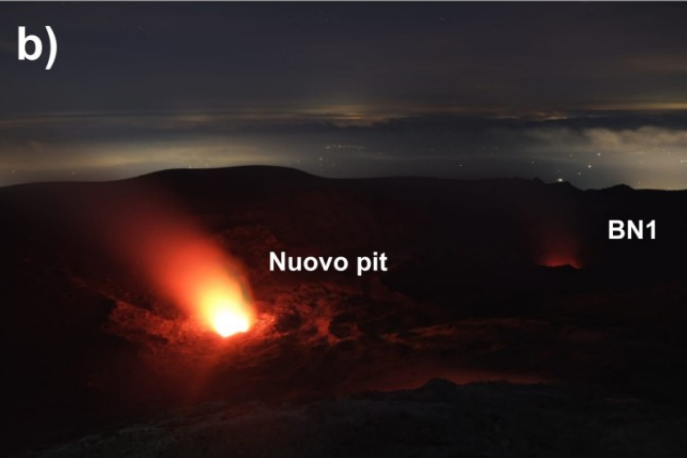
Degassing from the new collapse crater sometimes leads to the formation of vapor rings (volcanic vortex rings).
The Southeast crater showed the characteristic continuous degassing of the two vents located in the eastern sector of the cone, sometimes associated with nocturnal glow, and weak degassing from the numerous fumaroles located along the western edge of the crater.
Finally, the North-East Crater (CNE) and the Voragine crater (VOR) still remain obstructed and present weak fumarolic activity.
Source : INGV.
Photos : Gio Giusa , INGV.
Italy , Stromboli :
WEEKLY BULLETIN, from August 28, 2023 to September 3, 2023. (issue date September 5, 2023)
SUMMARY STATEMENT OF ACTIVITY
In light of the monitoring data, it appears:
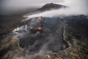
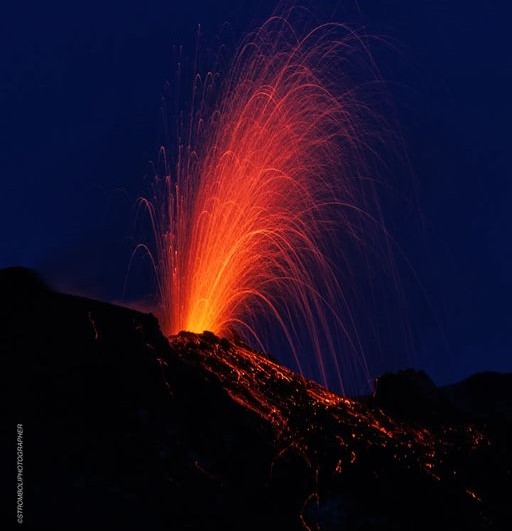
1) VOLCANOLOGICAL OBSERVATIONS: During this period, normal Strombolian activity was observed with splashing activity in the North Crater area. The total hourly frequency fluctuated between average values (12-15 events/h). The intensity of the explosions varied from low to medium in the North Crater area and from medium to high in the South-Central area.
2) SISMOLOGY: The monitored seismological parameters do not show significant variations
3) GROUND DEFORMATIONS: Two modest variations are noted in the inclinometer signal from the TDF tilt station.
4) GEOCHEMISTRY: SO2 flux at medium level
The CO2 flow in the Pizzo area shows stable values at average levels.
C/S ratio in the plume at high values
There is no update on the isotope ratio of dissolved helium in groundwater.
5) SATELLITE OBSERVATIONS: Thermal activity observed by satellite was generally weak with rare and isolated anomalies of moderate level.
VOLCANOLOGICAL OBSERVATIONS
During the observed period, the eruptive activity of Stromboli was characterized through the analysis of images recorded by the INGV-OE surveillance cameras at altitude 190m (SCT-SCV), from
Pizzo and Punta dei Corvi. The explosive activity was mainly produced by 2 (two) eruptive vents located in the northern area of the crater and by 3 (three) vents located in the south central area.
Observations of explosive activity captured by surveillance cameras
In the area of the North crater (N), with a vent located in sector N1 and one in sector N2, explosive activity of varying intensity from low (less than 80 m high) to medium (less than 150 m high). high) was observed in sector N1 and low in sector N2. The products emitted in the eruption were mainly coarse materials (bombs and lapilli). Additionally, occasional and weak splashing activity was observed in sectors N1 and N2. The average frequency of explosions fluctuated between 5 and 10 events/h.
In the South-Central (CS) zone, sector S1 and sector C did not show significant activity while sector S2, with three active vents, mainly showed explosive activity of varying intensity from low to high (greater than 150 m in height). emitting coarse matter mixed with fine matter (ash). The average frequency of explosions oscillated between 2 and 9 events/h.
Source : INGV.
Photo : Stromboli stati d’animo.
Alaska , Shishaldin :
AVO/USGS Volcanic Activity Notice
Current Volcano Alert Level: WARNING
Previous Volcano Alert Level: WATCH
Current Aviation Color Code: RED
Previous Aviation Color Code: ORANGE
Issued: Tuesday, September 5, 2023, 9:01 AM AKDT
Source: Alaska Volcano Observatory
Notice Number: 2023/A1356
Location: N 54 deg 45 min W 163 deg 58 min
Elevation: 9373 ft (2857 m)
Area: Aleutians
Volcanic Activity Summary:
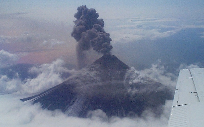
An ash cloud from Shishaldin Volcano reaching 25,000 ft (7.3 km) above sea level and rising was reported by a pilot at at 8:42 am AKDT (1642 UTC). Satellite data suggests that the cloud may be as high as 30,000 ft above sea level (9.1 km). This follows a several-hour increase in seismicity. In response, the Aviation Color Code is being raised to RED and the Volcano Alert Level is being raised to WARNING. The cloud is visible in satellite data moving towards the southeast and lightning associated with the ash cloud has been detected.
Based on previous eruption cycles, significant ash emissions are likely to continue for several hours. Pyroclastic and mudflows are likely on the immediate flanks of the volcano.
Shishaldin Volcano is monitored by local seismic and infrasound sensors, web cameras, and a telemetered geodetic network. In addition to the local monitoring network, AVO uses nearby geophysical networks, regional infrasound and lighting data, and satellite images to detect eruptions.
Issued: Tuesday, September 5, 2023, 12:31 PM AKDT
Volcanic Activity Summary:
An explosive eruption from Shishaldin began at ~08:30 AKDT (16h30 UTC) following a several-hour increase in seismicity and produced an extensive ash cloud that moved towards the south-southeast at an estimated altitude of 32,000 ft (9.7 km) above sea level. Around 19:00 AKDT (19h00 UTC) seismic amplitude decreased rapidly, and the altitude of the ash emissions as observed by satellite also decreased to an estimated altitude of ~15,000 ft (4.5 km). At 12:00 pm AKDT (20h00 UTC), the lower-altitude ash cloud extended for ~75 miles (125 km) towards the east. The Aviation Color Code and Volcano Alert Level remains at RED/WARNING.
The National Weather Service has issued a SIGMET for the ash cloud , a Special Weather Statement and a Marine Weather Statement has been issued for possible trace ash fall on Unimak Island and on nearby marine waters, respectively.
Issued: Tuesday, September 5, 2023, 2:14 PM AKDT
Current Aviation Color Code: ORANGE
Volcanic Activity Summary:
Activity at Shishaldin Volcano has declined. Web camera observations through 1:30 pm AKDT (21:30 UTC) show that significant ash emissions have ended. Seismicity decreased rapidly around 12:30 pm AKDT (20:30 UTC) and remains low. Thus, the Aviation Color Code and Volcano Alert Level are being decreased to ORANGE/WATCH.
The National Weather Service has issued a SIGMET for the ash cloud ,a Special Weather Statement and a Marine Weather Statement has been issued for possible trace ash fall on Unimak Island and on nearby marine waters, respectively
Source : AVO
Photos : Brekke, Matt , R. McGimsey .
Philippines , Kanlaon :
6 September 2023 , 9:00 A.M.
This is a notice of increased seismic activity at Kanlaon Volcano.
A total of thirty-six (36) volcanic earthquakes, including thirty-four (34) volcano-tectonic or VT earthquakes, have been recorded by the Kanlaon Volcano Network between 5:00 AM, 4 September and 7:50 AM, 6 September 2023. These earthquakes ranged in energy from ML0.8 to ML3.4 and occurred at depths of 0 to 9 kilometers beneath the northeast flank of the Kanlaon range. Ground deformation data from continuous GPS and electronic tilt measurements have been recording short-term inflation of the middle slopes since March 2023 and a longer-term inflation of the entire edifice since March 2022. Volcanic sulfur dioxide (SO2) gas emission from the summit crater averaged 412 tonnes/day on 20 August 2023 lower than the average emission of 623 tonnes/day last July 2023. While monitoring parameters in the past months have been consistent with shallow hydrothermal activity driven by degassing of deeper magma, ongoing VT earthquake activity indicates that fracturing at deeper levels is occurring and may possibly lead to further unrest.

The public is reminded that Alert Level 1 prevails over Kanlaon. Should the above uptrend in monitoring parameters persist, the volcano status may be raised to Alert Level 2 to warn of increasing unrest. The public and local government units are strongly advised to be vigilant and refrain from entering the four (4) kilometer Permanent Danger Zone (PDZ) due to increased chances of sudden and hazardous phreatic eruptions occurring without warning. Civil aviation authorities must also advise pilots to avoid flying close to the volcano’s summit as ejecta from any sudden phreatic eruption can be hazardous to aircraft. DOST-PHIVOLCS is closely monitoring Kanlaon Volcano’s activity and any new development will be relayed to all concerned.
Source et photo : Phivolcs
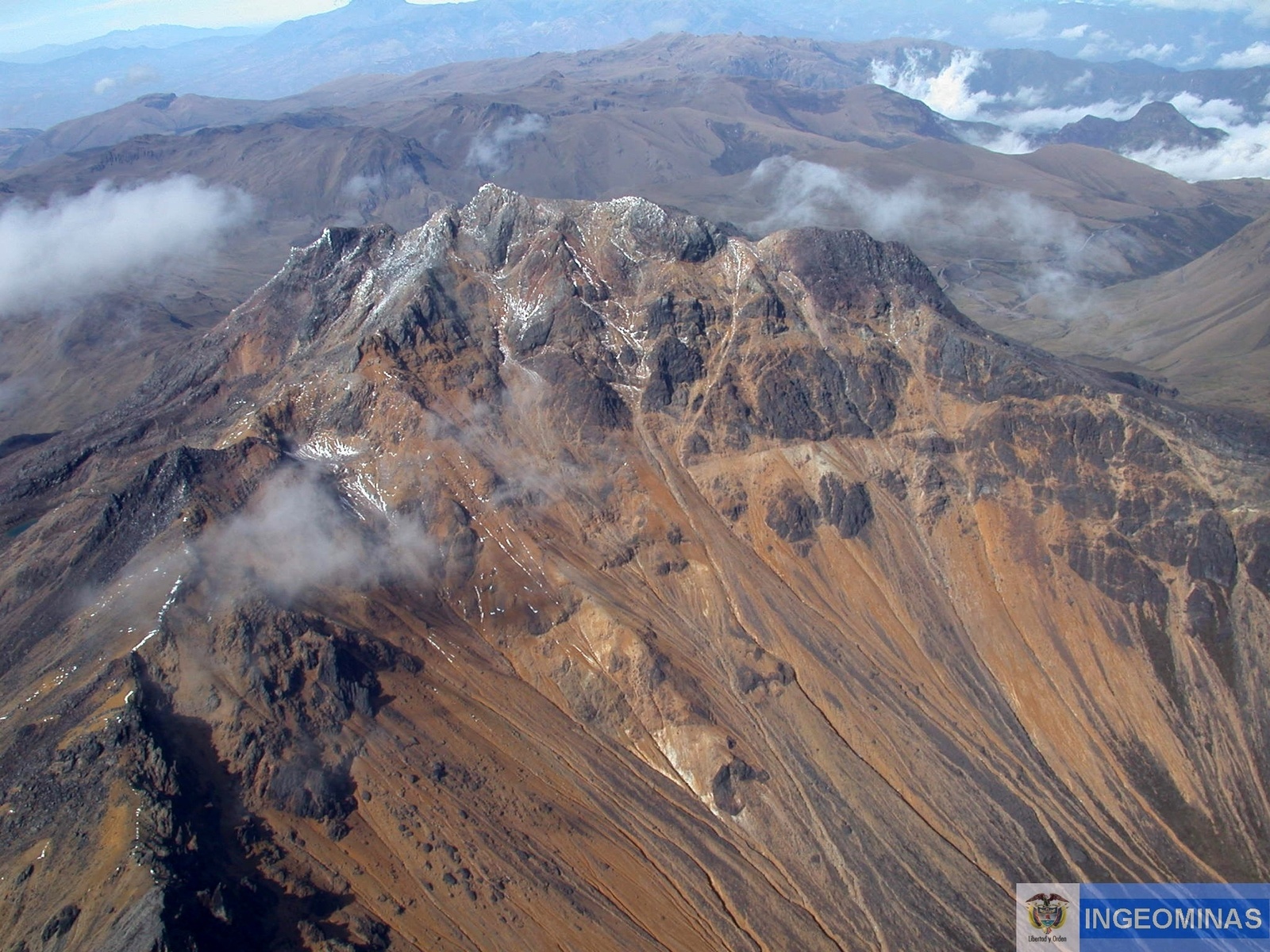
Colombia , Chiles / Cerro Negro :
Weekly activity bulletin of the Chilis and Cerro Negro Volcanic Complex (CVCCN)
Regarding the monitoring of the activity of the CHILES AND CERRO NEGRO VOLCANOES, the MINISTRY OF MINES AND ENERGY, through the COLOMBIAN GEOLOGICAL SERVICE (SGC), reports that:
Between August 29 and September 4, 2023 and compared to the previous week, seismicity showed a slight increase both in its occurrence and in its seismic energy released. The predominance of earthquakes associated with rock fracturing continued.
The earthquakes were located mainly in the southern quadrant of the Chiles volcano, at distances of up to 3 km, with depths less than 5 km compared to the height of its summit (4,700 m above sea level) and a maximum magnitude of 2.5. No felt earthquakes were reported. Note that on September 5 at 6:08 a.m., an earthquake of magnitude 2.9 was recorded, located 2.6 km to the South-South-West, with a depth of 4 km and without it being reported that it had been felt.
The deformation processes continued in different sectors of the volcanic edifice, detected instrumentally by the sensors installed on the volcano as well as by satellite sensors.
The seismicity occurring in the zone of influence of the Chiles – Cerro Negro volcanic complex is part of a fluctuating process that began at the end of 2013 and continues to this day. The most recent increase began on March 9, 2023, with the recording of more than 226,000 earthquakes in the last 6 months, most associated with the fracturing of rocks within the volcanic system, some of them them reported as felt by residents residing near the epicentral zone.
The recorded seismicity shows variations in its occurrence and mainly in its energy levels, due to the complex interaction between the CVCCN magmatic system, the hydrothermal system and the geological faults of the region. The occurrence of earthquakes of greater magnitude that can generate instability on slopes, landslides and structural damage to buildings, access roads, bridges, etc. is probable, aspects that must continue to be taken into account by the authorities and communities residing in the zone of influence of these volcanoes.
The probability of occurrence of energetic earthquakes that could be felt by residents of the CVCCN zone of influence is maintained.
The level of activity of volcanoes remains at the level:
YELLOW LEVEL ■ (III): CHANGES IN THE BEHAVIOR OF VOLCANIC ACTIVITY
Source : SGC.
Photo : Ingeominas.