May 02 , 2018.
Piton de la Fournaise , La Réunion :
Activity Bulletin from Tuesday, May 1, 2018 at 3:00 pm (local time).
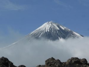
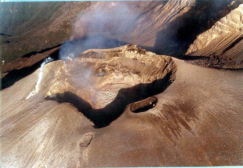
The eruption started on April 27, 2018 at 23:50 local time continues. The intensity of the volcanic tremor (indicator of surface eruptive intensity) is still relatively stable (Figure 1).
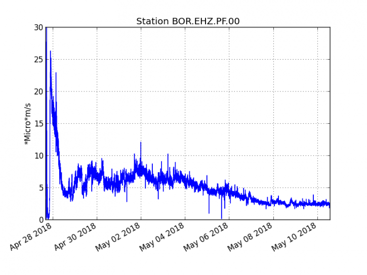
Figure 1: Evolution of the RSAM (Indicator of Volcanic Tremor and Eruption Intensity) between 20:00 (16:00 UTC) April 27 and 15:00 (11:00 UTC) May 1 at the BOR Seismic Station (at the top) . (© OVPF / IPGP)

– The surface flows estimated from the satellite data, via the HOTVOLC platform (OPGC – Clermont Ferrand), recorded today were of the order of 1 to 3 m3 / s.
– A very slight deflation (deflation) of the volcano begins to be recorded on the OVPF deformation sensors. This parameter will be followed in the next few days.
– No volcano-tectonic earthquake has been recorded in the last 24 hours under the Piton de la Fournaise building.
Source : OVPF
Photo : Clicanoo
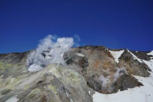
Pu’u’Ō’ō , Hawai :
HVO/USGS Volcanic Activity Notice
Current Volcano Alert Level: WATCH
Current Aviation Color Code: ORANGE
Issued: Tuesday, May 1, 2018, 4:54 AM HST
Source: Hawaiian Volcano Observatory
Notice Number:
Location: N 19 deg 25 min W 155 deg 17 min
Elevation: 4091 ft (1247 m)
Area: Hawaii
Volcanic Activity Summary:
A collapse of the Puʻu ʻŌʻō crater floor Monday afternoon on Kīlauea Volcano’s East Rift Zone has prompted increases in seismicity and deformation along a large section of the rift zone, with seismicity currently occurring as far east as Hwy 130. A outbreak of lava in a new location is one possible outcome. At this time it is not possible to say with certainty if or where such an outbreak may occur, but the area downrift (east) of Puʻu ʻŌʻō is the most likely location, as this is where seismicity and deformation have been concentrated overnight.
Residents of lower Puna should remain alert and watch for further information about the status of the volcano; watch for Hawaii County Civil Defense messages at http://www.hawaiicounty.gov/active-alerts

April 28, 2018, 6:00 am – Pu‘u ‘O‘o and Kilauea’s east rift zone overflight: A view of the west pit and perched pond, facing north. Note how much the floor of the pit has risen since Wednesday… the crack in the west wall and the red boulder are nowhere to be seen!
Recent Observations:
Between about 2:00 and 4:30 pm on Monday, April 30, following weeks of uplift and increasing lava levels within the cone, the crater floor at Pu’u ‘Ō’ō on Kīlauea Volcano’s East Rift Zone collapsed.
Poor weather prevented HVO from flying over the activity or seeing details of the activity in our web cameras on site.
Following the collapse, HVO seismometers and tiltmeters recorded an increase in seismic activity and deformation from Kīlauea Volcano’s summit to an area about 6-10 miles downrift (east) of Puʻu ʻŌʻō. Overnight, this activity localized downrift of Puʻu ʻŌʻō and continued to propagate eastward along the rift zone.
The largest earthquake of this sequence so far was a magnitude 4.0 earthquake just offshore south of Pu’u ‘Ō’ō at 02:39 this morning,
Kīlauea’s summit eruption has thus far not been affected by the change at Pu’u ‘Ō’ō.
Hazard Analysis:
The migration of seismicity and deformation downrift (east) of Puʻu ʻŌʻō cone following Monday’s collapse indicates that a large area along the East Rift Zone is potentially at risk for a new outbreak.
The location of any future outbreak will determine what areas are in the path of new lava flows.
The situation is rapidly evolving and USGS Hawaiian Volcano Observatory scientists continue to closely monitor Kīlauea’s East Rift Zone and summit. More updates will follow as information becomes available.

Starting at about 2:00 p.m. on Monday, April 30, marked increases in seismicity and ground deformation indicated that a change was underway at Pu‘u ‘Ō‘ō on Kīlauea Volcano’s East Rift Zone. Visibility was nearly obscured due to poor weather conditions, but a brief clearing allowed HVO’s webcam (POcam) to capture this image of the crater within Pu‘u ‘Ō‘ō shortly before the crater floor began collapsing. Unfortunately, due to ongoing poor weather, a clear view of the collapsed crater floor has not yet been possible. The Pu‘u ‘Ō‘ō crater floor continued to collapse for several hours yesterday; smaller drops in the crater floor have likely continued through today (May 1) based on thermal images.
Just after 2:00 p.m. HST today, April 30, 2018, a marked increase in seismicity and ground deformation (change in ground surface shape) began at Pu’u ‘Ō’ō on Kīlauea Volcano’s East Rift Zone. A few minutes later, a thermal webcam (PTcam) located on the rim of the Pu’u ‘Ō’ō crater showed the first of two episodes of crater floor collapse; the second collapse began at 3:20 p.m. and lasted about an hour. Webcam views into the crater and surrounding area were frequently obscured by poor weather conditions. However, shortly after 4:00 p.m., the PTcam recorded images that were likely the signature of small explosions from the western side of the crater as the floor collapsed. At the time of this update (6:00 p.m.), there was no evidence of new lava within the crater, seismicity remained elevated in the vicinity of Pu’u ‘Ō’ō, and ground deformation at Pu’u ‘Ō’ō had significantly slowed.
Kīlauea’s summit eruption has thus far not been affected by this afternoon’s activity at Pu’u ‘Ō’ō.
USGS Hawaiian Volcano Observatory scientists continue to closely monitor Kīlauea’s East Rift Zone and summit. A helicopter overflight of Pu’u ‘Ō’ō and the 61g flow field is scheduled for early Tuesday, weather permitting.
Source : HVO
Chiles / Cerro Negro , Colombia :
Subject: Chiles / Cerro Negro volcano activity bulletin.
The level of activity of volcanoes has remained at:
■ YELLOW LEVEL (III): changes in the behavior of volcanic activity.
On monitoring the activity of Chiles and Cerro Negro volcanoes, the Geological Survey of Colombia (CGT) reports that:
For the period evaluated, between April 24 and April 30, 2018 and the previous week, seismicity in the region of Chiles volcanoes – Cerro Negro, showed a slight increase in occurrence and in released energy. The recorded earthquakes are associated with rock fractures inside the volcano. Most of the localized events were located to the southwest and the more remote areas southeast of the Chiles volcano, at epicentral distances up to 12 km, with depths less than 8 km from the summit (4700 m) and a local maximum amplitude of M2.8 on the Richter scale. No events were reported as felt.
Cerro Negro.
The COLOMBIAN GEOLOGICAL SERVICE and the GEOPHYSICAL INSTITUTE OF THE NATIONAL POLITICAL SCHOOL OF ECUADOR closely monitor the evolution of this seismic activity and the volcanic phenomenon and will inform timely changes detected.
Source : SGC
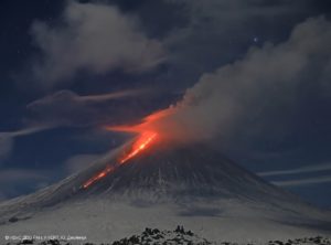
Marapi , Indonesiea:
VOLCANO OBSERVATORY NOTICE FOR AVIATION – VONA.
Issued: May 02 , 2018.
Volcano: Marapi (261140)
Current Aviation Colour Code: ORANGE
Previous Aviation Colour Code: unassigned
Source: Marapi Volcano Observatory
Notice Number: 2018MAR01
Volcano Location: N -0 deg 22 min 52 sec E 100 deg 28 min 23 sec
Area: West Sumatra, Indonesia
Summit Elevation: 9251 FT (2891 M)
Volcanic Activity Summary:
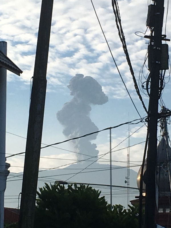
Eruption with volcanic ash cloud at 00h03 UTC (07h03 Local Time). Eruption and ash emission is not continuing.
Volcanic Cloud Height:
Best estimate of ash-cloud top is around 49805 FT (15564 M) above sea level, may be higher than what can be observed clearly. Source of height data: ground observer.
Other Volcanic Cloud Information:
High Pressure and Dark Grey ash-cloud moving to southeast.
Remarks:
Seismic activity is characterized by Deep Volcanic Earthquake.
The Merapi volcano with an altitude of 2891 meters above sea level, is located administratively in the region and district of Batusangkar Agam Regency, West Sumatra Province. Its last eruption activity occurred on April 27, 2018, ash eruption up to 300 meters high, spreading a thin layer of ash on Tanah Datar, Cubadak area 12 km from the center of the eruption (Verbeek crater) .
On May 2, 2018 at 7:03 pm, Return of an eruptive column with a height of 4000 m high, thick, gray, strong pressure, with a wind direction during the eruption to the southeast.
The seismic stations, on May 2, 2018 until 8 pm, recorded:
1 eruption earthquake,
1 local tectonic earthquake,
1 Tornillo type earthquake,,
2 distant tectonic earthquakes.
Seismicity last week showed:
1 eruption earthquake,
4 emission earthquakes,
7 volcanic earthquakes,
5 local earthquakes,
7 distant tectonic earthquakes.
In coordination in preparation for the eruption of G. Marapai by BPBD Tanah Datar and BPBD Agam, BMKG and Airport in West Sumatra, information on the explosion and altitude was reported in the VONA app as an early warning for aviation safety.
The activity status of the Marapi volcano so far is still at the level of activity Waspada (level II).
Recommendations: People around the Gunungapi Marapi and visitors / tourists are not allowed to climb on the Marapi within a radius of 3Km around the crater / peak.
Source : Magma Indonésie. Centre de Volcanologie et d’Atténuation des Risques Géologiques
Agence géologique, Ministère de l’ESDM