September 03 , 2023 .
Mexico , Popocatepetl :
September 1, 11:00 a.m. (September 1, 5:00 p.m. GMT)
Activity from the last 24 hours
30 exhalations were detected, accompanied by water vapor, volcanic gases and sometimes light amounts of ash. In addition, 18 minutes of tremors and two explosions were recorded; one moderate and one minor recorded yesterday at 4:14 p.m. and 5:02 p.m. local time as well as two volcano-tectonic earthquakes detected yesterday at 7:39 p.m. and today at 2:23 a.m. with magnitudes of 1.6 and 2.1 respectively.
During the morning and at the time of this report, a constant emission of water vapor and volcanic gases was observed in a West-South-West (WSW) direction.
September 1, 3:15 p.m. (September 1, 9:15 p.m. GMT)
Actualization
At 00:16, a new segment of low to medium amplitude and high frequency tremor began, accompanied by continuous emission of water vapor, gas and low ash content. The column reached a height of 2 km, dispersing in a westward direction. . At the time of this report, the amplitude of the tremor has decreased significantly.
Derived from the activity, the National Center for Communication and Operation of Civil Protection (CENACOM) reported at 3:10 p.m., ash falls in the municipalities of Ozumba, Atlautla, Tepetlixpa and Ecatzingo belonging to the State of Mexico.
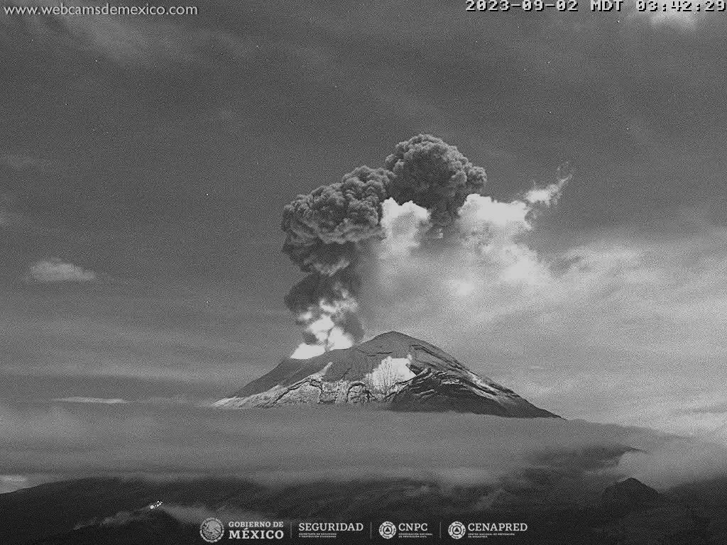
September 2, 8:48 p.m. (September 3, 02:48 GMT)
Actualization
At 6:10 p.m., a new segment of low to medium amplitude and high frequency tremor began, accompanied by continuous emission of water vapor, gas and ash. The column reached a height of 1 km, dispersing in a west-northwest direction. At the time of this report, the amplitude of the tremor has decreased significantly.
Following this activity, the National Center for Civil Protection Communication and Operations (CENACOM) reported ash falls in the municipalities of Amecameca, Ayapango, Ozumba, Juchitepec, Tenango del Aire, Atlautla and Tlalmanalco.
The Popocatépetl volcanic warning fire is in yellow phase 2.
Source et photo : Cenapred
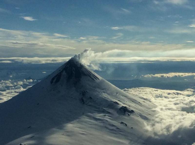
Alaska , Shishaldin :
Friday, September 1, 2023, 12:03 PM AKDT (Friday, September 1, 2023, 20:03 UTC)
54°45’19 » N 163°58’16 » W,
Summit Elevation 9373 ft (2857 m)
Current Volcano Alert Level: WATCH
Current Aviation Color Code: ORANGE
The most recent significant explosive event at Shishaldin Volcano, the eighth to occur during this eruptive period, happened earlier in the week on August 25-26. Throughout the day on August 25 seismic tremor increased in intensity and was accompanied by infrasound detections of small explosions and by highly elevated surface temperatures that were observed in satellite data. A Volcano Observatory Notice for Aviation (VONA) was issued at 11:36 AKDT (1936 UTC) maintaining the Aviation Color Code at ORANGE but informing of the likelihood of significant ash emissions in the next several hours.
Shortly thereafter pilot reports of ash emissions to approximately 30,000 ft above sea level were received and the Aviation Color Code and Volcano Alert Level were increased to RED/WARNING at 12:04 AKDT (2004 UTC). Ash emissions were visible in satellite data, although partly obscured by meteorological clouds. Seismicity continued to increase through ~16:30 AKDT (0030 UTC on August 19), before dropping precipitously. Ash emissions continued after the drop in seismicity and were observed in satellite data through 00:00 AKDT (0800 UTC) on August 26. With seismicity at pre-event levels and no further observation of ash emissions in satellite data the Aviation Color Code and Volcano Alert Level were reduced to ORANGE/WATCH at 0030 AKDT (0830 UTC) on August 26, where it has remained throughout the rest of the week.
Low-level activity has continued over the remainder of the week. Seismicity remains above background and elevated surface temperatures were observed in the summit crater throughout the week. An AVO field crew working on Unimak Island observed a mass flow down the upper flanks of the volcano beginning around 5:20 pm AKDT on August 27. The flow produced a short-lived ash cloud that rose to about 15,000 ft (4.5 km) above sea level and quickly dissipated. These mass flows are likely caused by the collapse of lava spatter that is accumulating on the summit crater rim. This type of activity remains a proximal hazard as the deposits collapse occasionally without warning and generate hot flows on the upper flanks and small clouds of volcanic ash.
Shishaldin has had eight periods of explosive eruptive activity resulting in significant ash emissions since July 12. It is unknown how long this eruptive period will last. Previous eruptions of Shishaldin Volcano have lasted weeks to months with repeated cycles of activity similar to those seen since July 12. Before the current activity, the 2019–2020 eruption of Shishaldin was the first to result in lava flows outside the crater area since 1976. Minor eruptions in 2004 and 2014 erupted lava confined to the summit crater. Previous eruptions of Shishaldin have produced ash clouds like those seen during the current eruption, most recently in January 2020. Routine evaluations of satellite, seismic, and infrasound data provide warning of unrest associated with the production of ash clouds.
Local seismic and infrasound sensors, web cameras, and a geodetic network monitor Shishaldin Volcano. In addition to the local monitoring network, AVO uses nearby geophysical networks, regional infrasound and lightning data, and satellite observations to detect eruptions.
Source : AVO.
Photos : R. McGimsey , Wetzel, Tarek . ( archives)
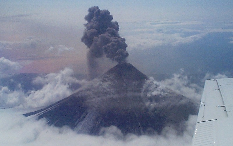
Philippines , Mayon :
MAYON VOLCANO BULLETIN 03 September 2023 8:00 AM
In the past 24-hour period, slow effusion of lava from the summit crater of Mayon Volcano continued to feed the established lava flows on the Bonga (southeastern), Mi-isi (south), and Basud (eastern) gullies. The lava flows have maintained their respective advances to approximately 3.4 kilometers, 2.8 kilometers, and 1.1 kilometers from the crater. Rockfall and pyroclastic density currents or PDCs generated by collapses of the lava flow margins as well as of the summit dome deposited debris still within four (4) kilometers of the crater. The Mayon Volcano Network recorded a total of eight (8) volcanic earthquakes.
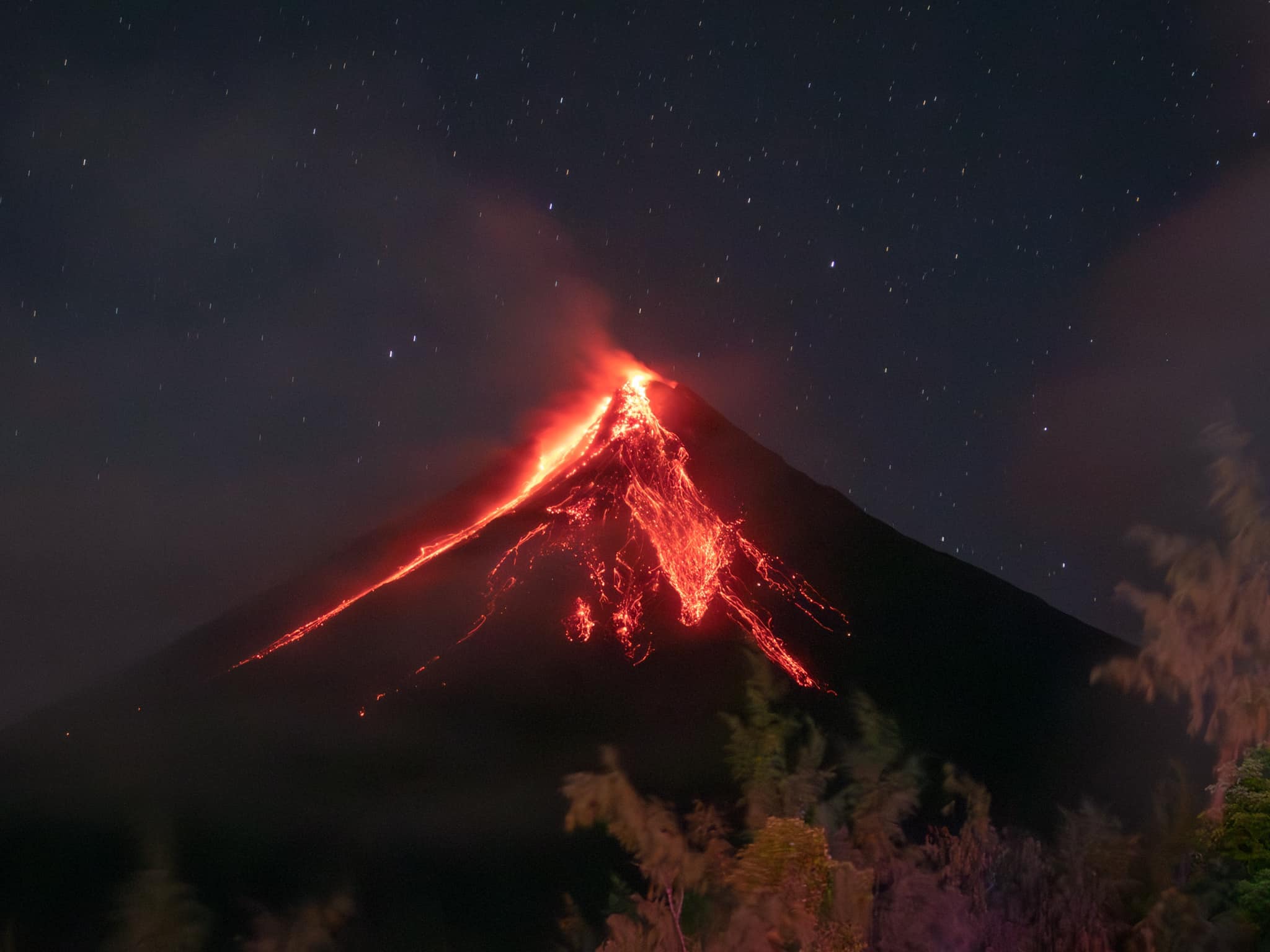
Additionally, the network detected one hundred thirty-seven (137) rockfall events and two (2) PDC events. Volcanic sulfur dioxide (SO2) emission averaged 1,987 tonnes/day on 02 September 2023. Short-term observations from electronic tilt and GPS monitoring indicate pronounced inflation of southeastern middle slopes since the beginning of August 2023. Longer-term ground deformation parameters from EDM, precise leveling, continuous GPS, and electronic tilt monitoring indicate that Mayon is still generally inflated relative to baseline levels.
Alert Level 3 is maintained over Mayon Volcano, which means that it is currently in a relatively high level of unrest and hazardous eruption within weeks or even days could still be possible.
Source : Phivolcs
Photo : Rick Estillomo
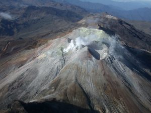
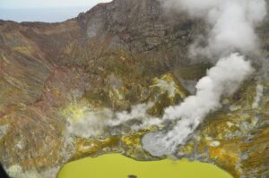
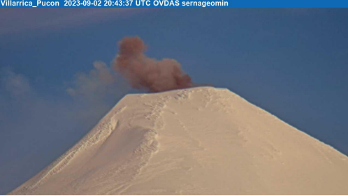
Chile , Villarica :
Special Report on Volcanic Activity (REAV), La Araucanía and Los Ríos regions, Villarrica volcano, September 2, 2023, 5:05 p.m. local time (mainland Chile)
The National Geology and Mining Service of Chile (Sernageomin) announces the following PRELIMINARY information, obtained through the monitoring equipment of the National Volcanic Monitoring Network (RNVV), processed and analyzed at the Southern Andean Volcano Observatory (Ovdas):
On Saturday September 2, 2023, at 4:43 p.m. local time (Saturday September 2, 8:43 p.m. UTC), monitoring stations installed near the Villarrica volcano recorded an earthquake associated with fluid dynamics inside the volcanic system (LP type), accompanied by a small pulse of particulate matter.
The characteristics of the earthquake, after its analysis, are as follows:
ORIGINAL TIME: 4:43 p.m. local time (8:43 p.m. UTC)
REDUCED TRAVEL: 68.14 (cm*cm)
ACOUSTIC SIGNAL: 2.7 (Pa) reduced to 1 km
The characteristics of this activity are as follows:
MAXIMUM COLUMN HEIGHT: 180 feet above point of emission
DIRECTION OF SPREAD: South-East (SE)
COMMENTS:
Following this event, no changes were recorded in the seismic behavior of the volcano.
The technical volcanic alert is maintained at the Yellow level.
Source et photos : Sernageomin.
Hawaii , Kilauea :
Friday, September 1, 2023, 8:02 AM HST (Friday, September 1, 2023, 18:02 UTC)
19°25’16 » N 155°17’13 » W,
Summit Elevation 4091 ft (1247 m)
Current Volcano Alert Level: ADVISORY
Current Aviation Color Code: YELLOW
Activity Summary:
Kīlauea volcano is not erupting. Kīlauea’s summit is currently exhibiting signs of elevated unrest. No unusual activity has been noted along the volcano’s East Rift Zone or Southwest Rift Zone.
Summit Observations:
Elevated seismic activity continues in an area south of Kīlauea’s summit caldera. Steady rates of earthquakes have persisted in this area since August 22, and there was a small, brief swarm last night. Most of these earthquakes have occurred at depths of 1–2 miles (2–3 kilometers) below the surface, with no upward migration detected. Summit tiltmeters have tracked mostly steady inflation since August 29, following a longer-term period of gradual inflation dating back to the end of the last eruption in June. Sulfur dioxide (SO2) emissions from the summit remain low; the most recent SO2 emission rate of approximately 75 tonnes per day was measured on August 24.
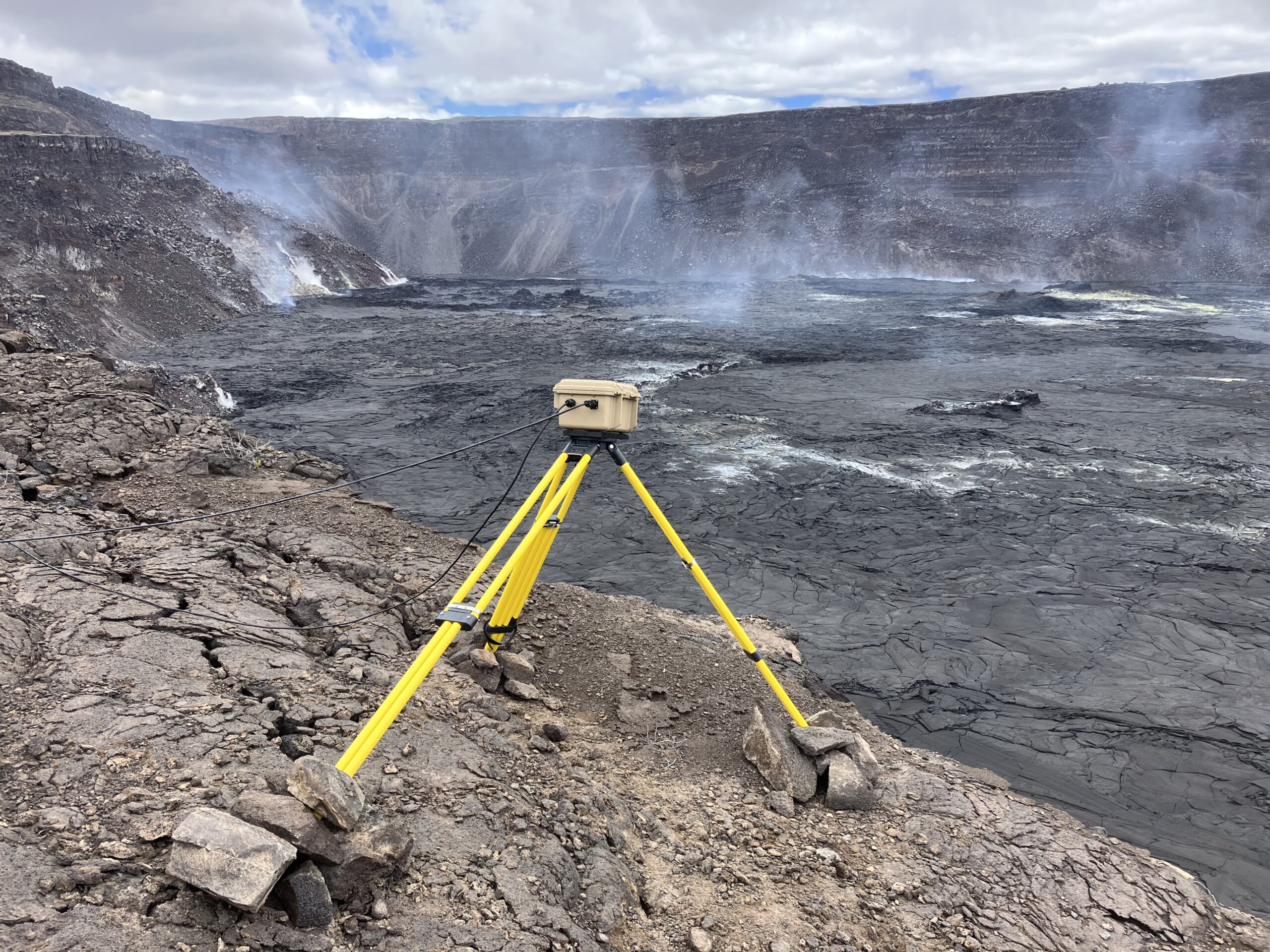
Last week, HVO staff installed a new webcam—the B2cam—on the down-dropped block within Kīlauea caldera and east rim of Halema‘uma‘u crater. This camera view replaces that of the B1cam, which was moved east during the June 2023 Halema‘uma‘u eruption because it was being exposed to intense heat. The B2cam is located farther south than B1cam was, on a ledge that stands about 100 feet (30 meters) higher. The B2cam provides a low-angle westward view of Halema‘uma‘u crater floor.
The seismic and tilt data indicate that Kīlauea’s summit is becoming increasingly pressurized. Similar episodes of earthquake and ground deformation activity occurred in November 2020 and August 2021, prior to eruptions in December 2020 and September 2021. The unrest is currently confined within Kīlauea’s summit region and—if it continues—could escalate to an eruption in the coming days, weeks, or months. The activity could also decrease due to intrusion of magma underground or other changes, resulting in no eruption. Furthermore, levels of activity are expected to rise and fall during this period of unrest.
Source : HVO
Photo : USGS / M. Zoeller.