September 01 , 2023.
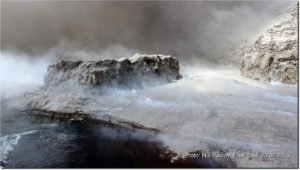
Italy , Vulcano :
WEEKLY BULLETIN, from August 21, 2023 to August 27, 2023. (issue date August 29, 2023)
SUMMARY STATEMENT OF ACTIVITY
In light of the monitoring data, it appears:
1) Temperature of the crater fumaroles: The temperatures recorded on the edge of the crater remain stable. The maximum temperature range recorded during the week is between 334 and 347°C.
2) CO2 flux in the crater area: The CO2 flux in the crater area increases slightly. The weekly average is at average degassing values (4530 g/m2/day).
3) SO2 flow in the crater area: at an average level
4) Geochemistry of fumarolic gases: There are no updates, the data from the last sampling (07/08/2023) highlight constant or slightly increasing concentration values of magmatic species over average values, medium-high; the isotopic composition does not show significant changes compared to previous sampling.
5) CO2 fluxes at the base of the La Fossa cone and in the Vulcano Porto area: The CO2 fluxes recorded in the Rimessa, Camping Sicilia and Faraglione sites show stable values, equal to or close to their respective background levels with a slight increase observed on the Rimessa site, Camping Sicilia. On the P4max site the CO2 flow presents increasing values essentially determined by a decrease in atmospheric pressure.
6) Geochemistry of thermal aquifers: Pozzo Camping Sicilia: increasing temperature values are always observed at high levels, conductivity decreases slightly; Bambara wells: stable level and conductivity values.
7) Local seismicity: Low rate of occurrence of local micro-seismicity.
8) Regional seismicity: No earthquake with a magnitude equal to or greater than 1.0 was recorded.
9) Deformations – GNSS: The network of permanent GNSS stations has not recorded any significant variations.
10) Deformations – Inclinometry: The inclinometric network did not record any significant variations.
11) Gravimetry: No significant variation was recorded.
GEOCHEMISTRY OF FUMEROLIAN GAS
There are no updates, the analysis of samples taken from the fumaroles of the crater on 07/08/2023 highlights that the concentration of species indicative of a magmatic contribution (i.e. CO2 and He) is stable in one of the fumaroles sampled and slightly increasing in another, with values between 14 and 20% for CO2, which remain at a medium or medium-high level. The data on the isotopic composition of carbon and helium indicate stable values compared to the last sample.
Source : INGV
Photo : INGV-Roma1
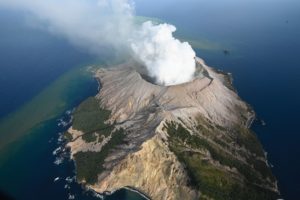
Alaska , Shishaldin :
Thursday, August 31, 2023, 12:22 PM AKDT (Thursday, August 31, 2023, 20:22 UTC)
54°45’19 » N 163°58’16 » W,
Summit Elevation 9373 ft (2857 m)
Current Volcano Alert Level: WATCH
Current Aviation Color Code: ORANGE
Low-level explosive activity is likely occurring within the summit crater of Shishaldin Volcano. High winds masked seismic observations and no events were seen in the noisy data. Satellite and web camera views were obscured by clouds over the past day.
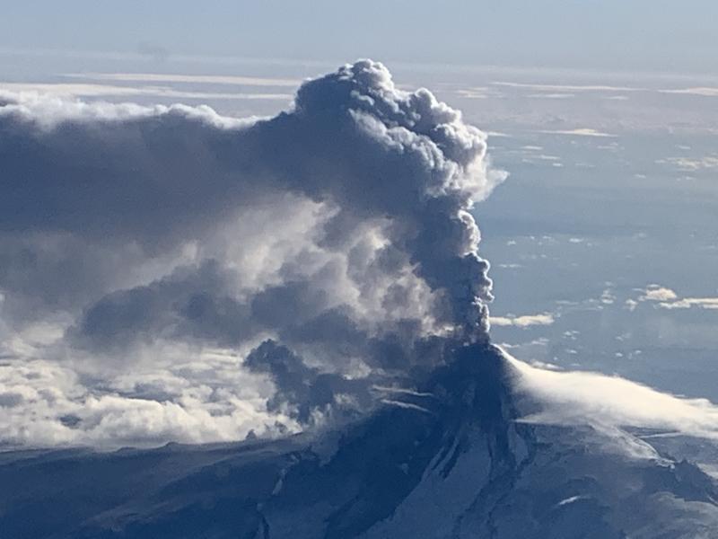
Shishaldin has now had eight periods of elevated eruptive activity resulting in significant ash emissions and mass flows of volcanic debris on the volcano’s flanks. These periods of elevated eruptive activity have been preceded by increases in seismicity in the hours before they occur. Collapse of accumulated lava near the summit crater can occur without warning and generate hot mass flows on the upper flanks and small volcanic ash clouds. The ongoing eruptive period started on July 12, and it is unknown how long this eruptive episode will last. However, previous eruptions of Shishaldin Volcano have lasted weeks to months with repeated cycles of activity like those seen over the last month.
Local seismic and infrasound sensors, web cameras, and a geodetic network monitor Shishaldin Volcano. In addition to the local monitoring network, AVO uses nearby geophysical networks, regional infrasound and lighting data, and satellite images to detect eruptions
Source : AVO.
Photo : Woodsen Saunders , avo.
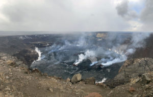
Hawaii , Kilauea :
19°25’16 » N 155°17’13 » W,
Summit Elevation 4091 ft (1247 m)
Current Volcano Alert Level: ADVISORY
Current Aviation Color Code: YELLOW
Activity Summary:
Kīlauea volcano is not erupting. Kīlauea’s summit is currently exhibiting signs of elevated unrest. No unusual activity has been noted along the volcano’s East Rift Zone or Southwest Rift Zone.
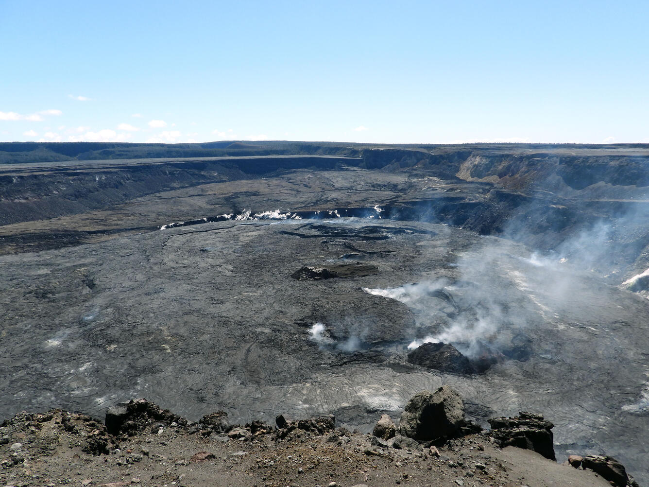
Summit Observations:
Elevated seismic activity continues in an area south of Kīlauea’s summit caldera. Steady rates of earthquakes have persisted in this area since August 22, with no notable swarms in the past day. Most earthquakes have occurred at depths of 1–2 miles (2–3 kilometers) below the surface, with no upward migration detected. Summit tiltmeters have tracked slow inflation for the past two days, except for a brief period of minor deflation early this morning. Sulfur dioxide (SO2) emissions from the summit remain low; the most recent SO2 emission rate of approximately 75 tonnes per day was measured on August 24.
The seismic and tilt data indicate that Kīlauea’s summit is becoming increasingly pressurized. Similar episodes of earthquake and ground deformation activity occurred in November 2020 and August 2021, prior to eruptions in December 2020 and September 2021. The activity is currently confined within Kīlauea’s summit region and—if it continues—could escalate to an eruption in the coming days, weeks, or months. The activity could also decrease due to intrusion of magma underground, or other changes, resulting in no eruption. Furthermore, levels of activity are expected to rise and fall during this period of unrest.
Source : HVO
Photo : USGS / K. Mulliken.
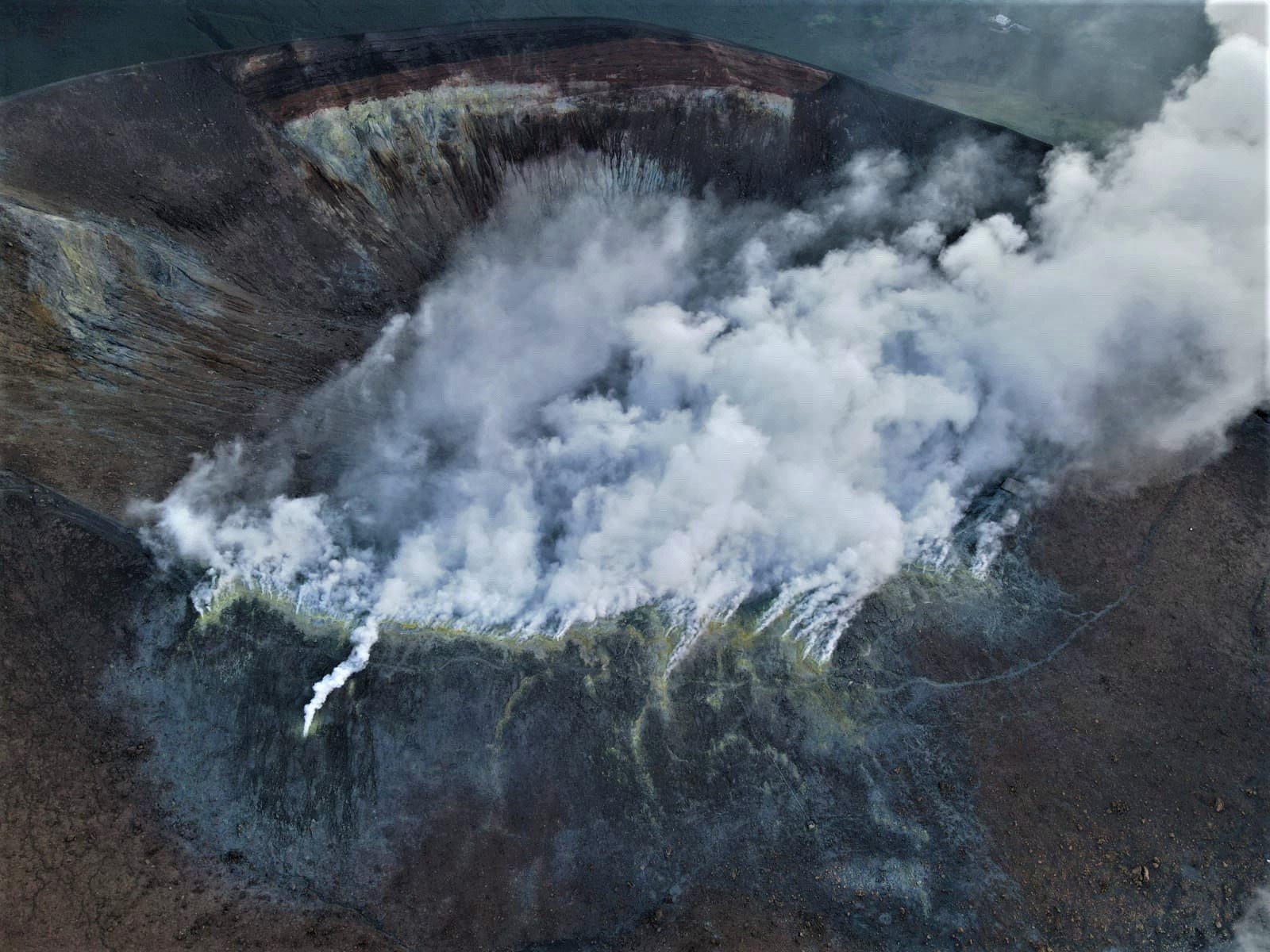
Indonesia , Ibu :
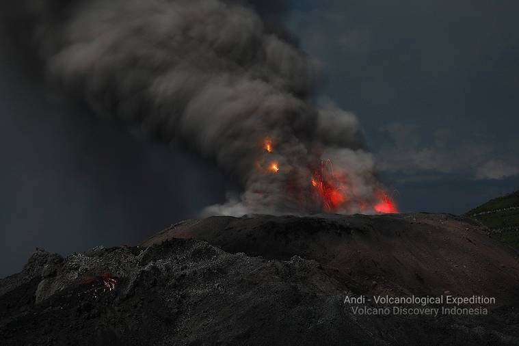
Mount Ibu exhibited an eruption on Thursday, August 31, 2023 at 10:46 p.m. WIT with the height of the ash column observed at ±1,500 m above the summit (±2,825 m above sea level). The ash column was observed to be gray with a thick intensity, oriented towards the North. This eruption was recorded on a seismograph with a maximum amplitude of 28 mm and a duration of 88 seconds.
VOLCANO OBSERVATORY NOTICE FOR AVIATION – VONA
Issued : August 31 , 2023
Volcano : Ibu (268030)
Current Aviation Colour Code : ORANGE
Previous Aviation Colour Code : orange
Source : Ibu Volcano Observatory
Notice Number : 2023IBU029
Volcano Location : N 01 deg 29 min 17 sec E 127 deg 37 min 48 sec
Area : North Maluku, Indonesia
Summit Elevation : 4240 FT (1325 M)
Volcanic Activity Summary :
Eruption with volcanic ash cloud at 13h57 UTC (22h57 local).
Volcanic Cloud Height :
Best estimate of ash-cloud top is around 9040 FT (2825 M) above sea level or 4800 FT (1500 M) above summit. May be higher than what can be observed clearly. Source of height data: ground observer.
Other Volcanic Cloud Information :
Ash cloud moving to north. Volcanic ash is observed to be gray. The intensity of volcanic ash is observed to be thick.
Remarks :
Eruption recorded on seismogram with maximum amplitude 28 mm and maximum duration 88 second.
Source : Magma Indonésie.
Photo : Andi Rosati / Volcanodiscovery.
Colombia , Puracé – Chaîne volcanique Los Coconucos :
Weekly bulletin of the activity of the Puracé volcano – Los Coconucos volcanic chain
Monitoring the activity of the PURACE VOLCANO – LOS COCONUCOS VOLCANIC CHAIN, the MINISTRY OF MINES AND ENERGY through the COLOMBIAN GEOLOGICAL SERVICE (SGC)
reports that:
During the week of August 22-28, 2023, seismic activity showed a similar trend to that observed in previous weeks, maintaining values above the baseline.
of historical activity, both in energy released and in number of events recorded. Seismic events linked to the movement of fluids in volcanic conduits predominated, located mainly under the crater of the Puracé volcano. This activity was accompanied by localized deformations in the upper part of the volcanic chain. In addition, stable values were recorded in the flow of sulfur dioxide (SO2) and high values in the concentration of carbon dioxide (CO2) compared to what was recorded in the second half of 2022.
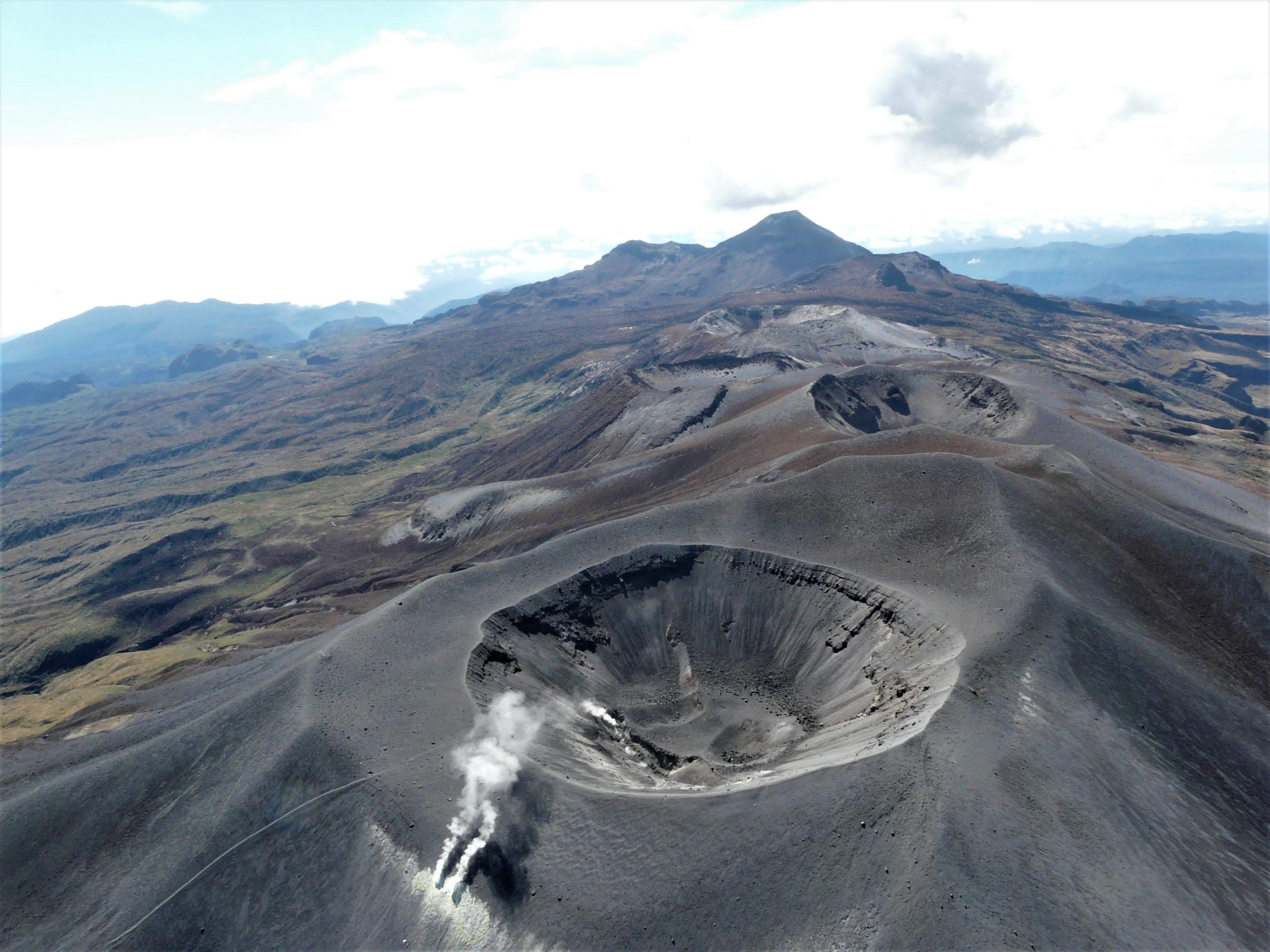
The other parameters measured and used for the diagnosis of volcanic activity showed no notable changes during the period evaluated.
The level of activity of the volcano remains at
YELLOW LEVEL (III): CHANGES IN THE BEHAVIOR OF VOLCANIC ACTIVITY
The COLOMBIAN GEOLOGICAL SERVICE will continue to monitor the evolution of the volcanic phenomenon and will inform in a timely manner of any changes that may occur.
Source et photo : SGC