January 07 , 2020 .
New Zealand , White Island :
Volcanic Alert BulletinWI – 2020/01 . Mon Jan 6 2020 8:30 PM; White Island Volcano
Volcanic Alert Level remains at 2
Aviation Colour Code is lowered to Yellow
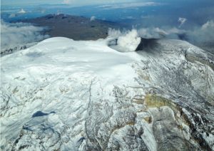
Whakaari/White Island remains in an elevated state of unrest. Very hot gas and steam continue to discharge from the December 9th vents. Further eruptions over 24 hours on any given day are very unlikely in the next four weeks. The Volcanic Alert Level remains at Level 2. The Aviation Colour Code changes to Yellow as ash only rarely gets emitted at the vent.
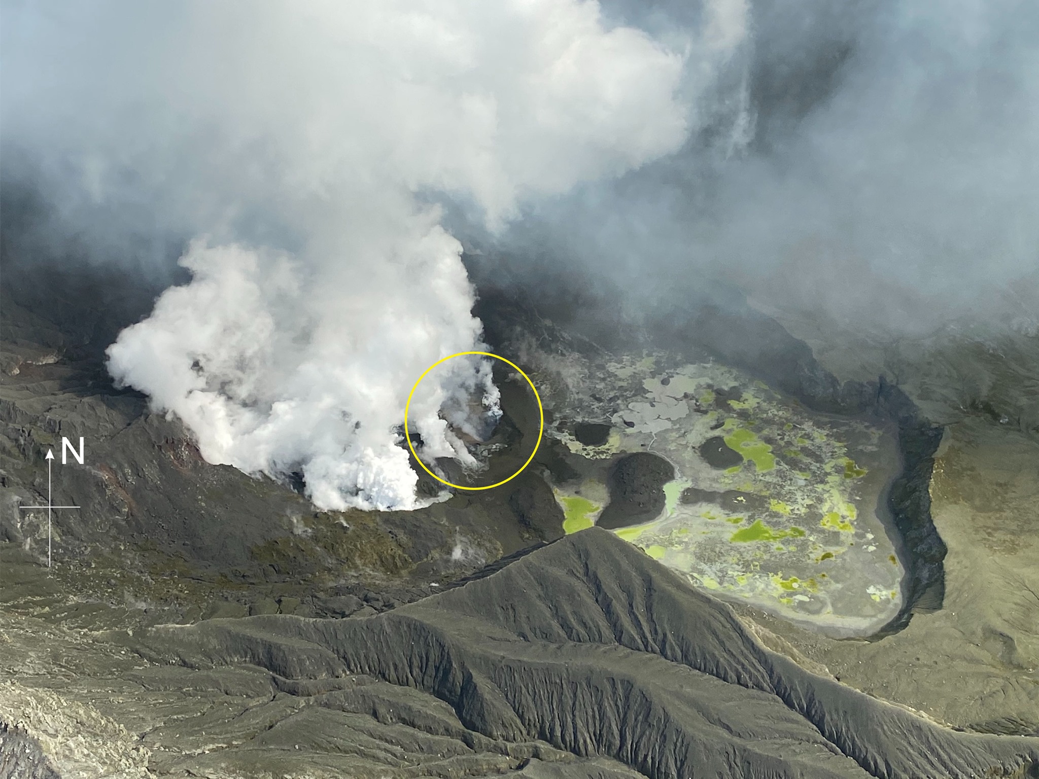
No further eruptive activity has been observed since the December 9th eruption. Strong emissions of steam and gases continue from the December 9th vent area which remains very hot, causing a glow in this area that is seen on our near infrared cameras. The level of volcanic tremor has remained low since 14/12/2019. This, along with SO2 emission rates within normal range, suggest that no significant amount of magma has been on the move since making it to the surface shortly after the eruption.
Occasionally small amounts of ash can be emitted from the active vent due to erosion. This has been observed twice on December 23rd and December 26th. Neither was significant enough to carry ash beyond the island.
Satellite data shows continued land movement of the back crater wall west of the 1914 landslide. We continue to monitor the rate of movement and are assessing the likelihood of future landslides into the vent area.
This morning our team’s experts estimated the likelihood of another eruption occurring and affecting the area beyond the crater lake edge between now and midday Monday February 3rd. This expert elicitation indicates another eruption being very unlikely (1 – 2 %) for any 24-hour period through to midday Monday February 3rd. Consequently, the distances for GNS Science staff-access zones have been reduced but remain too large for GNS Science staff to access the island for standard operations. The expert elicitation will be reviewed again on Monday February 3rd, or sooner if the level of activity changes.
An explosive eruption from the hot gas vent area remains possible and could occur with no precursory activity, especially if there is a collapse of unstable material around one of the vents, or if the gas emission decreases markedly, allowing water to enter the hot gas vent. Sudden steam/gas eruptions from other active vents are also possible.
Should any explosive activity produce an ash cloud, the likelihood of ash affecting the mainland in the next week remains low.
All our monitoring equipment on the island is operating. We are working to reinstate the Whakaari White Island webcams into the GeoNet website and will advise via GeoNet facebook and twitter when these are available.
Volcanic Alert Level 2 indicates moderate to heightened unrest with potential for eruption hazards including unpredictable and life-threatening steam driven eruptions.
The Volcanic Alert Level reflects the current level of volcanic activity and is not a forecast of future activity.
Source : Geonet / Yannik Behr / Duty Volcanologist .
Read the article : https://www.geonet.org.nz/vabs/5eYMPLyVaBq4M6HxE1F38v
Photos : George Novak , Geonet .
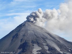
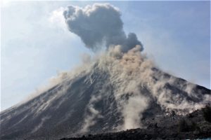
Peru , Sabancaya :
Analysis period: December 30, 2019 to January 5, 2020. Arequipa, January 6, 2020.
Alert level: ORANGE
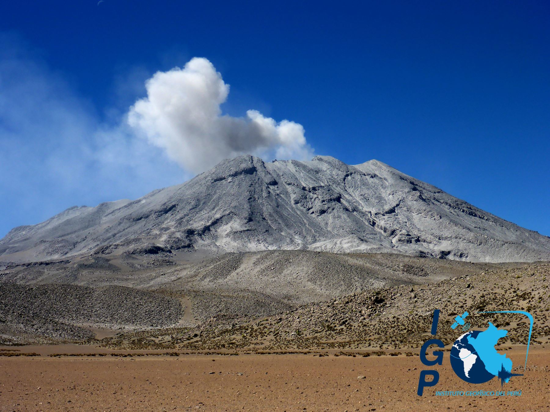
The Geophysical Institute of Peru (IGP) reports that the eruptive activity of the Sabancaya volcano has been maintained at moderate levels; that is, with the continuous recording of moderate explosions and the resulting ash emissions. Consequently, for the following days, no significant change in activity is expected.
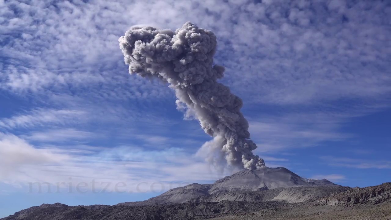
During the period from December 30, 2019 to January 5, 2020, the IGP recorded and analyzed the occurrence of approximately 1,179 earthquakes of volcanic origin, the highest percentage of which is associated with the circulation of fluids (magma , gas, etc.) inside the volcano. During this period, there were on average 9 explosions per day of medium to low intensity.
The monitoring of the deformation of the volcanic structure, using GNSS data (processed with fast orbits), does not record any significant anomalies. Visual surveillance, using surveillance cameras, allowed us to identify the presence of columns of gas and ash up to 2 km high above the summit of the volcano, scattered in the North, South-East and east of Sabancaya. Satellite surveillance has identified the presence of a 4 MW thermal anomaly, associated with the presence of a lava dome in the crater of the volcano, about 280 m in diameter. It should be noted that the number of anomalies has been reduced due to the high cloudiness in the region.
Source : IGP.
Photo : Martin Rietze .
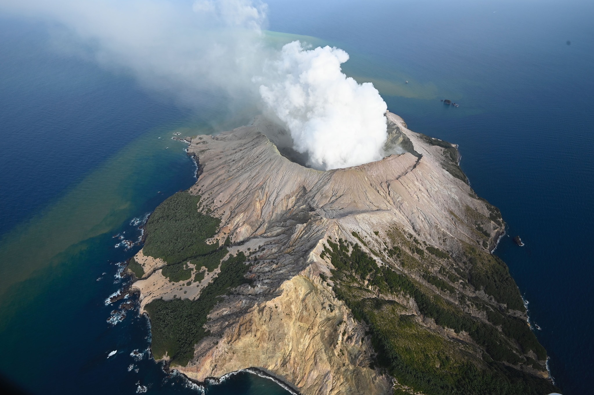
Indonesia , Anak Krakatau :
VOLCANO OBSERVATORY NOTICE FOR AVIATION – VONA.
Issued: January 07 , 2020.
Volcano: Anak Krakatau (262000)
Current Aviation Colour Code: ORANGE
Previous Aviation Colour Code: orange
Source: Anak Krakatau Volcano Observatory
Notice Number: 2020KRA02
Volcano Location: S 06 deg 06 min 07 sec E 105 deg 25 min 23 sec
Area: Lampung, Indonesia
Summit Elevation: 502 FT (157 M)
Volcanic Activity Summary:
recorded eruption at 00:36 UTC (07:36 local )
Volcanic Cloud Height:
Best estimate of ash-cloud top is around 1142 FT (357 M) above sea level, may be higher than what can be observed clearly. Source of height data: ground observer.
Other Volcanic Cloud Information:
visually from cctv crater seen volcanic ash moving to east, volcanic ash white-gray thick 200 meters high from the bottom of the crater.
Remarks:
Eruption recorded on seismogram with maximum amplitude 36 mm and duration 101 second.
Gunung Anak Krakatau erupted again at 07:36 WIB, Tuesday (7/1). This eruption is the first eruption of 2020.
The height of the ash column reached 200 meters from the top above the crater. Now the height of Mount Anak Krakatau reaches 157 meters above sea level.
« The height of the ash column was observed at 200 meters or 357 meters above sea level. It was the first eruption in 2020, » said Andi Suandi, chief of the surveillance post at Gunung Anak Krakatau Lampung, once confirmed by its cellular connection, from Serang, Tuesday.
Source : Magma Indonésie , Merdeka.com.
Video : Kondisi .
Peru , Ubinas :
Analysis period: December 30, 2019 to January 5, 2020. Arequipa, January 6, 2020.
Alert level: ORANGE
The Geophysical Institute of Peru (IGP) reports that the eruptive activity of the Ubinas volcano remains at low levels. To date, the energy of earthquakes associated with the rise of magma to the surface has considerably decreased. There are weak and sporadic emissions of bluish gases (of magmatic origin) and water vapor, observed through surveillance cameras. According to this scenario, the possibility of volcanic explosions and / or ash emissions is low.
During the period from December 30, 2019 to January 5, 2020, the IGP recorded and analyzed a total of 68 seismic events associated with the dynamic behavior of the Ubinas volcano, with the predominance of seismic signals of Volcano-Tectonic (VT) type the fracturing of the rocks inside the volcano which, on average, recorded 7 earthquakes per day, all of magnitude less than M2.4. The seismic signals linked to the rise of magma (hybrid type) decreased, both in the number of events (2 daily earthquakes) and in their energy. It should be noted that on January 4, seismic signals were recorded which were linked to the descent of two lahars into the Volcanmayo gorge, which occurred between 4:00 p.m. and 5:30 p.m.
Visual surveillance, although limited by cloud cover at this time of the year, records very low emissions of volcanic gases. Monitoring the deformation of the volcanic structure, using GNSS data (processed with fast orbits), does not record any anomalies. MIROVA satellite surveillance also did not record thermal anomalies on the volcano.
Source : IGP.