
July 08 , 2023.
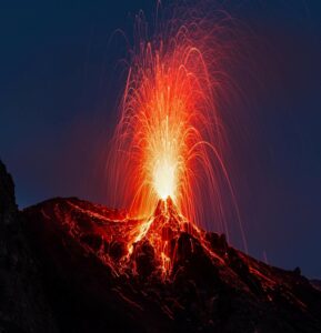
La Réunion , Piton de la Fournaise :
Press release from the Paris Institute of Earth Physics, Piton de la Fournaise Volcanological Observatory, July 07, 2023 – 1:00 p.m. – 9:00 a.m. UTC
Ongoing eruption
The eruption started on July 02, 2023, around 08:30 local time continues. The amplitude of the volcanic tremor (indicator of an emission of lava and gas on the surface) is relatively stable. Even if some fluctuations persist, the gas-pistons – associated with the periodic rise of gas packets in the building – are no longer recorded.
Lava flow estimates established by satellite method on the HOTVOLC (OPGC – Clermont Auvergne University) and MIROVA (University of Turin) platforms over the past 24 hours indicated flows between 2 and 9 m3 / sec. Given the cloud mass present regularly on the eruptive site, these flows can be reduced.
From these flows, it is estimated that a volume of between 4 and 4.5 Mm3 of lava has been emitted to the surface since the start of the eruption.
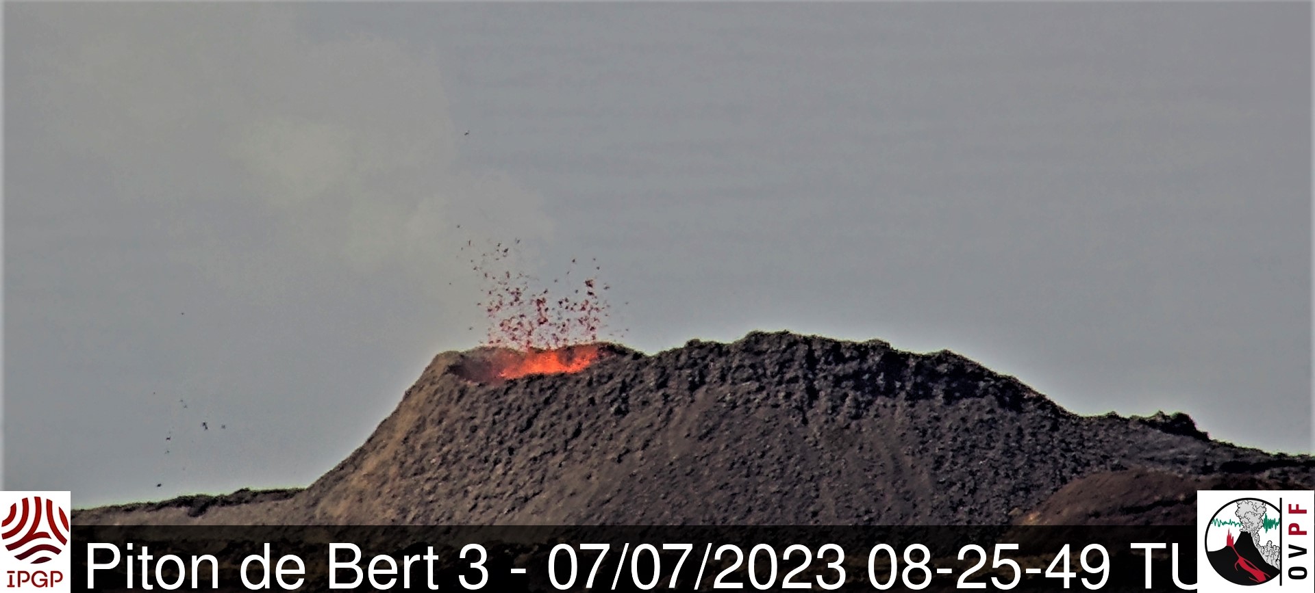
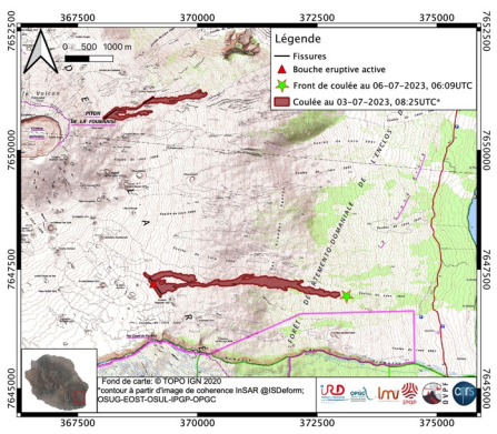
The activity is now concentrated at the level of the eruptive mouth located to the south-east of the Enclos Fouqué at 1720 m altitude. The volcanic cone continues its construction by accumulation of lava projections.
Active lava flows are now concentrated on the upper part of the Grandes Pentes. The flow front has not changed for more than 48 hours and an overview of the area yesterday morning by a team from the OVPF-IPGP made it possible to locate it precisely 1.8 km from the road.
The deflation of the whole edifice continues even if it has slowed down considerably in the last 48 hours. This deflation is linked to the emptying of the magmatic reservoir located about 2 km below the summit of Piton de la Fournaise which is feeding the current eruption.
Seismic activity is still recorded below the summit area. Thus over the last 24 hours, 33 superficial volcano-tectonic earthquakes have been recorded. This decrease leads to a decrease in the risk of the appearance of a new opening at lower altitude and/or of collapse in the crater, but does not mean that it can be excluded.
Alert level: Alert 2-1 (eruption in the Enclosure without any particular threat to the safety of people, property or the environment)
Source et photos : OVPF
Iceland , Reykjanes Peninsula :
About 7000 earthquakes since July 4th. Records strongly suggest that magma is migrating towards the surface
Updated 7. July 2023 at 1:30pm
Since the onset of the seismic swarm in the Reykjanes peninsula, on 4 July, 7000 earthquakes have been recorded in the area between Fagradalsfjall and Keilir. Roughly 300 earthquakes have been manually checked. This activity is caused by a new dike intrusion in the area, namely between Fagradalsfjall and Keilir and its centre is believed to be between Litli-Hrútur and Litli-Keilir. A total of 17 earthquakes larger than 4 have been recorded and 50 events larger than 3. The largest earthquake occurred at UTC 8:21 on 5 July and was 4,8. The largest earthquakes are felt widely in the SW-area, from Hella to the east and towards Snæfellsnes peninsula in the north. A continuation of this activity is expected but seismic activity has decreased somewhat in the vicinity of the dike. Seismic activity has continued in the area between Keilir and Fagradalsfjall, which is interpreted to be triggered events.
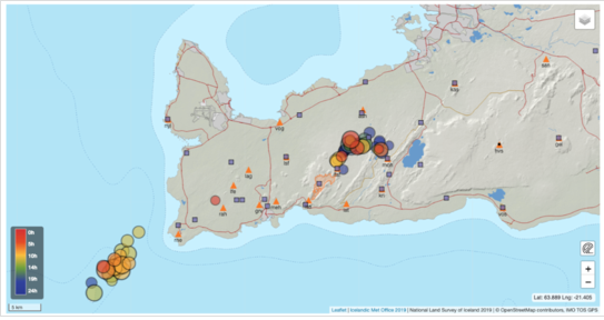
In spite of decreasing seismic activity, deformation seen in GPS and InSAR records strongly suggests that magma is migrating towards the surface. Interferogram (InSAR) images based on satellite radar data showing deformation occurring between 28 June to 6 July confirm the results from IMO’s GPS and seismic data regarding the magmatic intrusion . Model calculations based on the interferogram and GPS data suggest that the upper level of the dike reached 1 km depth early yesterday (6 July) causing a fracture of a 2.8 km length between Fagradalsfjall and Keilir, with a centre just north of Litli-Hrútur. These results are in good agreement with the seismic activity. The calculations also suggest that magma inflow rate is almost twice as fast compared to the antecedent of the eruption in August 2022, but the total volume of magma which has reached the upper part of the crust is similar, around 12 million cubic metres. The most recent GPS data indicates that magma is still migrating closer to the surface.
Presently, over 400 earthquakes have been recorded on the Reykjanes ridge, closer to Eldey. Of those, 35 events have been checked. About ten earthquakes larger than 3 have been confirmed and six larger than 4, the largest one measuring 4,5 which took place today 7 July 2023 at 5:06. Although seismic swarms are not uncommon in this area, this activity is now unusually high. Heightened activity on the Reykjanes ridge now is potentially triggered by the dike intrusion in Fagradalsfjall, but other causes cannot be ruled out. Deformation data do not suggest that the activity is caused by magma movement, but further research and data is needed.
Source : IMO.
Photos : IMO , webcam
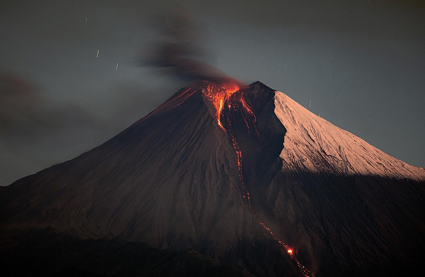
Indonesia , Merapi :
Report on the activity of Mount Merapi from June 30, 2023 to July 06, 2023, Published on July 07, 2023.
RESULTS OF OBSERVATIONS
Visual
The weather around Mount Merapi is usually sunny in the morning and afternoon, while the evening is foggy. White, fine to thick smoke, low to medium pressure and 150 m high was observed from the Mount Merapi observation post in Badaban on June 30, 2023 at 09:30.
This week, a hot cloud avalanche occurred on July 5, 2023 at 8:26 p.m. near Kali Bebeng, with a slip distance of 2700. Lava avalanches were observed 117 times to the southwest (upstream of Kali Bebeng) with a maximum slip distance of 2000 m. The sound of the avalanches was heard 27 times from the Babadan post with low to medium intensity.
On the Southwest dome, morphological changes have been observed due to lava avalanches. For the central dome, no significant morphological change was observed. Based on the results of a drone survey on May 17, 2023, the measured volume of the Southwest dome was 2,372,800 m3 and the central dome was 2,337,300 m3.

Seismicity
This week, the seismicity of Mount Merapi showed:
1 hot cloud avalanche (APG)
92 deep volcanic earthquakes (VTB),
1128 avalanche earthquakes (RF),
27 tectonic earthquakes (TT).
543 multi-phase (MP) earthquakes
9 low frequency (LF) earthquakes.
In general, the intensity of seismicity this week is higher than last week.
Deformation
Mount Merapi’s deformation that was monitored using EDM and GPS this week showed a shortening rate of 2 cm/day.
Rain and lahars:
This week there was rainfall at the Mount Merapi observation post with a rain intensity of 14 mm/h for 25 minutes at the Ngepos post on July 1, 2023.
Conclusion
Based on the results of visual and instrumental observations, it is concluded that:
-The volcanic activity of Mount Merapi is still quite high in the form of effusive eruption activity. The state of the activity is defined at the « SIAGA » level.
The current danger potential is in the form of lava avalanches and hot clouds in the South-South-West sector comprising the Boyong River for a maximum of 5 km, the Bedog, Krasak, Bebeng rivers for a maximum of of 7 km. In the South-East sector, it includes the Woro River for a maximum of 3 km and the Gendol River for 5 km. While the ejection of volcanic material in the event of an explosive eruption can reach a radius of 3 km from the summit.
Source : BPPTKG
Photo : imamismadin
Kamchatka , Sheveluch :
56.64 N, 161.32 E;
Elevation 3283 m (10768 ft),
dome elevation ~2500 m (8200 ft)
Aviation Colour Code is ORANGE
An extrusive-effusive eruption of the volcano continues. A danger of ash explosions up to 10 km (32,800 ft) a.s.l. is remains. Ongoing activity could affect international and low-flying aircraft.
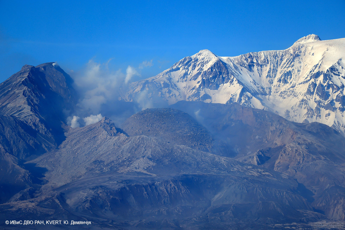
The extrusive-effusive eruption of the volcano continues: a lava is squeezed out in the explosive crater of the Young Sheveluch, it is accompanied by powerful gas-steam activity, and sometimes an incandescence of the lava dome. In the area of the Karan dome, powerful gas-steam activity is also observed, probably associated with the growth of a new lava dome. According to KVERT satellite data, thermal anomalies were observed in the area of the active dome and Karan dome all week; the plumes of resuspended ash extended for 100 km to the west and east-southeast of the volcano on 30 June, and 01-02 and 04-05 July.
Source : Kvert
Photo : Yu. Demyanchuk, IVS FEB RAS, KVERT
Ecuador , Sangay :
DAILY REPORT OF THE STATE OF SANGAY VOLCANO, Friday July 07, 2023.
Information Geophysical Institute – EPN.
Surface Activity Level: High, Surface Trend: Unchanged
Internal activity level: High, Internal trend: No change
Seismicity: From July 06, 2023, 11:00 a.m. to July 07, 2023, 11:00 a.m.:
Below is the count of seismic events recorded by the reference station over the past 24 hours.
Explosion Event (EXP): 643.
Rains / Lahars:
No rain was recorded in areas near the volcano. ** In the event of heavy rains, these could remobilize the accumulated materials, generating mudslides and debris that would descend the flanks of the volcano and pour into the adjacent rivers. **
Emission / Ash Column:
Due to cloudiness in the volcano area, no emissions were observed.
Other Monitoring Parameters:
During the last 24 hours, the MIROVA-VIIRS satellite systems recorded 1 moderate thermal anomaly (26 MW) and the MIROVA-MODIS satellite system recorded 1 moderate thermal anomaly (36 MW).
Observation:
During the night yesterday, emissions of incandescent materials were observed, mainly associated with the recorded explosions. For the moment, the volcano remains cloudy.
Alert level: Orange.
Source : IGEPN.
Photo : Eqphos_fotografía


No comment yet, add your voice below!