June 15 , 2023.
La Réunion , Piton de la Fournaise :15 Juin
Press release, Institute of Earth Physics of Paris
Volcanological Observatory of Piton de la Fournaise, June 13, 2023 – 06:00 (local time) – 02:00 (UTC time)
Increase in seismicity
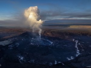
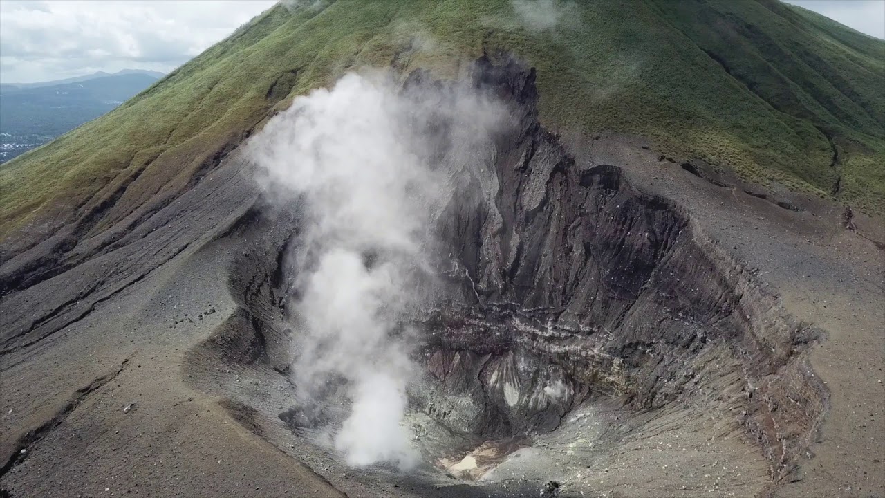
Since June 10, 2023, an increase in seismicity has again been observed under the Piton de la Fournaise. Thus 9 volcano-tectonic earthquakes were recorded on June 10, 8 on June 11 and 40 on June 12. These earthquakes are of low magnitude (<1), most are not localizable but some of these events could be located between 1.5 and 2 km deep under the Dolomieu crater.
This resumption of seismicity follows a pressurization of the superficial reservoir, located about 1.5-2 km deep under the Dolomieu crater, between March and May 2023 and which had given rise to an intrusion on April 21.
The resumption of seismicity at the roof of the reservoir shows that this process of pressurization is resuming.
It should be noted that this process of pressurizing the superficial reservoir can last several days to several weeks before the roof of the reservoir weakens and does not rupture, thus giving rise to an injection of magma towards the surface and an eruption, but can also stop without giving rise – in the short term – to an eruption.
Niveau d’alerte : Vigilance
Source : direction de l’OVPF-IPGP
Photo : Tunnels de lave Réunion : Rando-Volcan
Indonesia , Lokon – Empung :
Press release on the volcanic activity of G. Lokon, June 15, 2023.
The level of activity of G. Lokon is level II (Waspada) since August 24, 2016. The last eruption occurred in 2011 in the form of an eruption of ash and ejection of incandescent material which fell around the crater. Crater fumarole activity since January 2023 is generally white, weak to thick with a height of 20 to 150 meters. Seismicity is dominated by shallow volcanic earthquakes with an average occurrence of 1 in. 2 events per day. Phreatic eruptions can potentially occur suddenly if there is enough precipitation.
The latest developments in Lokon activity until June 13, 2023 at 10:00 WITA are as follows:
There was an increase in smoke activity from the crater on June 12, 2023 in the form of thick white smoke reaching a height of up to 400 meters from the Tompaluan crater followed by an increase in seismicity under the form of a continuous tremor with an amplitude of 1 – 25 mm (mainly 5 mm) which occurred from 6:35 p.m. to 9:00 p.m. WITA. Emission earthquakes were also observed to have increased so that 12 incidents were recorded.
Based on visual and instrumental data, it is indicated that there is an increase in surface pressure after the recorded earthquake. The tremor is associated with the release of gas puffs.
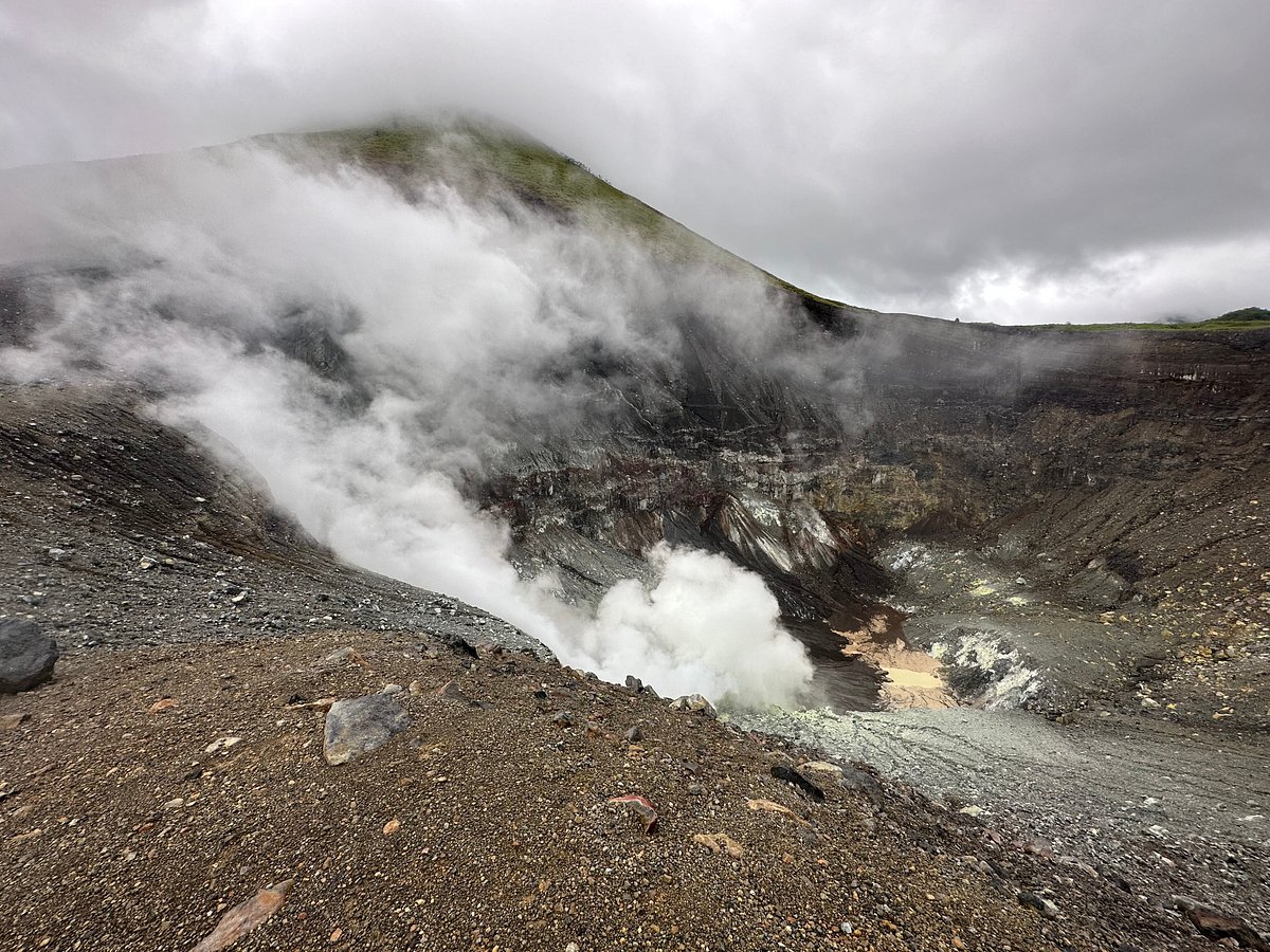
The potential danger to Lokon activity for now is a sudden phreatic eruption (an eruption caused by the contact of magma vapor with hydrothermal water) which may be followed by a phreato-magmatic to magmatic eruption . Eruptions may be accompanied by an ejection of incandescent material ranging in size from lapilli to lumps and heavy ash rain with or without being followed by a sudden eruption of hot clouds.
Based on the results of observations, analysis of visual and instrumental data as of June 13, 2023 at 10:00 a.m. WITA, the activity level of Lokon is still at level II (Alert). The recommendations for this Level II activity level (Alert) are as follows:
Communities and tourists should not approach and carry out activities within 1.5 km of the Tompaluan crater (activity center).
Source : Magma Indonésie.
Photo : lumbalumba resort , Manado , Paul S.
Philippines , Taal :
Over the past 24-hour period, active degassing of the Taal Main Crater has been observed in the form of visible upwelling of volcanic fluids in the Main Crater Lake and generation of voluminous steam-rich plumes that rose 2,100 meters above Taal Volcano Island. In consequence, significant volcanic smog or vog has formed over Taal Caldera and its surrounding areas since yesterday. An average of 5024 tonnes/day of volcanic sulfur dioxide or SO2 gas was remitted by Taal 12 June 2023.
20 volcanic earthquakes including 5 volcanic tremors (duration 2-3 minutes) were recorded
As a reminder, vog consists of fine droplets containing volcanic gas such as SO2 which is acidic and can cause irritation of the eyes, throat and respiratory tract with severities depending on the gas concentrations and durations of exposure. People who may be particularly sensitive to vog are those with health conditions such as asthma, lung disease and heart disease, the elderly, pregnant women and children.
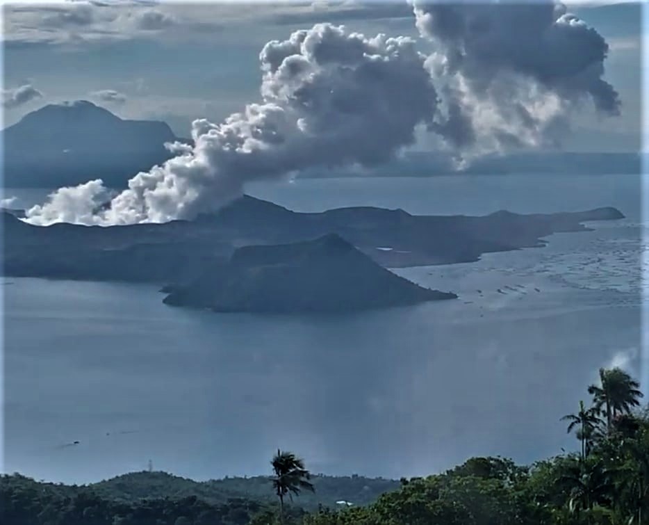
PHIVOLCS reported continuing low-level unrest at Taal during 6-13 June characterized by elevated seismicity, upwelling in the lake, and sulfur dioxide gas emissions. Volcanic tremor located at shallow depths along the Daang Kastila fissure was continuous with almost 166 hours recorded during 2-9 June; periods of volcanic tremor also took place 4-7 times each day during 9-12 June, each lasting 2-97 minutes. There were 1-11 volcanic earthquakes recorded on most days. Upwelling gasses and hot fluids in the lake continued to be visible almost daily, and voluminous white steam-and-gas plumes that rose as high as 3 km above the lake drifted NW, E, and SSE. Daily sulfur dioxide emissions averaged 2,941-6,884 tonnes per day. The steam-and-gas plumes produced voggy conditions in the caldera during 6-9 June, prompting an advisory to the public to be issued on 7 June. The Alert Level remained at 1 (on a scale of 0-5), and PHIVOLCS reminded the public that the entire Taal Volcano Island was a Permanent Danger Zone (PDZ).
Source : Phivolcs , GVP.
Photo : Kyle Aranza
Colombia , Nevado del Ruiz :
Manizales, June 14, 2023 11:35 a.m.
Regarding the monitoring of the activity of the NEVADO DEL RUIZ VOLCANO, the MINISTRY OF MINES AND ENERGY through the COLOMBIAN GEOLOGICAL SERVICE (SGC) informs that:
From 9:00 am yesterday (June 13) until the time of publication of this bulletin, the activity of this volcano, in general terms, continues to show low levels with minor variations.
Compared to June 13, seismicity associated with the movement of fluids inside volcanic conduits showed similar levels in the number of earthquakes and a slight increase in seismic energy. Some of the seismic signals were associated with pulsating ash emissions confirmed by web cameras used for volcanic monitoring.
For its part, the seismicity linked to the fracturing of the rocks inside the volcanic structure has decreased in number of earthquakes and in seismic energy. The earthquakes were of low energy and were located in the northeast sector of the volcano, at distances between 1 and 3 km from the crater, and with depths varying between 1 and 5 km from the summit of the volcano.

Regarding surface activity, the maximum observed height of the gas, steam and / or ash emission column was 300 m measured from the summit of the volcano and the preferential direction of dispersion was maintained towards the North- West of volcanic structure. In addition, variations in the degassing of sulfur dioxide and the release of water vapor from the crater into the atmosphere continued. Due to the atmospheric conditions in the area, there have been no reports of thermal anomalies at the bottom of the crater, but that does not mean that they are not yet present there.
Source et photo : SGC
Japan , Suwanosejima :
JMA reported that the eruption at Suwanosejima’s Ontake Crater continued, though monitoring parameters had been showing a declining trend. Blocks had not been ejected more than 1 km from the crater after 15 February and the number of explosions had decreased since March. GNSS (Global Navigation Satellite Systems) deformation measurements did not indicate accumulating magma beneath the W part of the island and the number volcanic earthquakes in that area was low. Eruptive activity during 7, 9-10, and 12 June generated ash plumes that rose 1-1.5 km above the crater rim and drifted in multiple directions. An explosion at 18h03 on 7 June produced an ash plume that rose 1.4 km and drifted E. Explosions were recorded at 02h30 on 9 June and 17h58 on 10 June, though details of any emissions were unknown. The Alert Level was lowered to 2 (on a 5-level scale) at 1100 on 9 June and the public was warned to stay 1 km away from the crater.
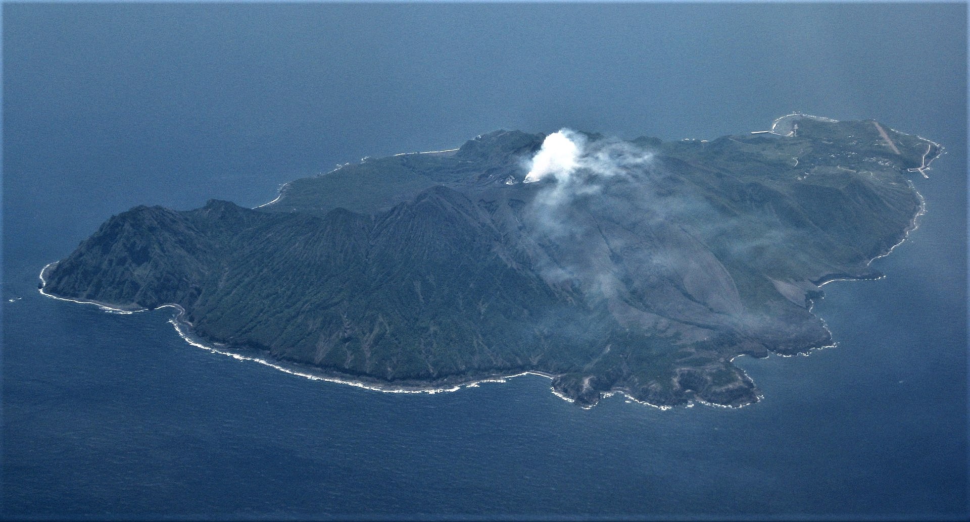
The 8-km-long island of Suwanosejima in the northern Ryukyu Islands consists of an andesitic stratovolcano with two historically active summit craters. The summit is truncated by a large breached crater extending to the sea on the east flank that was formed by edifice collapse. One of Japan’s most frequently active volcanoes, it was in a state of intermittent Strombolian activity from Otake, the NE summit crater, between 1949 and 1996, after which periods of inactivity lengthened. The largest recorded eruption took place in 1813-14, when thick scoria deposits blanketed residential areas, and the SW crater produced two lava flows that reached the western coast. At the end of the eruption the summit of Otake collapsed, forming a large debris avalanche and creating the open Sakuchi caldera, which extends to the eastern coast. The island remained uninhabited for about 70 years after the 1813-1814 eruption. Lava flows reached the eastern coast of the island in 1884. Only about 50 people live on the island.
Source : GVP.
Photo : Ray Go.