March 08 , 2022 .
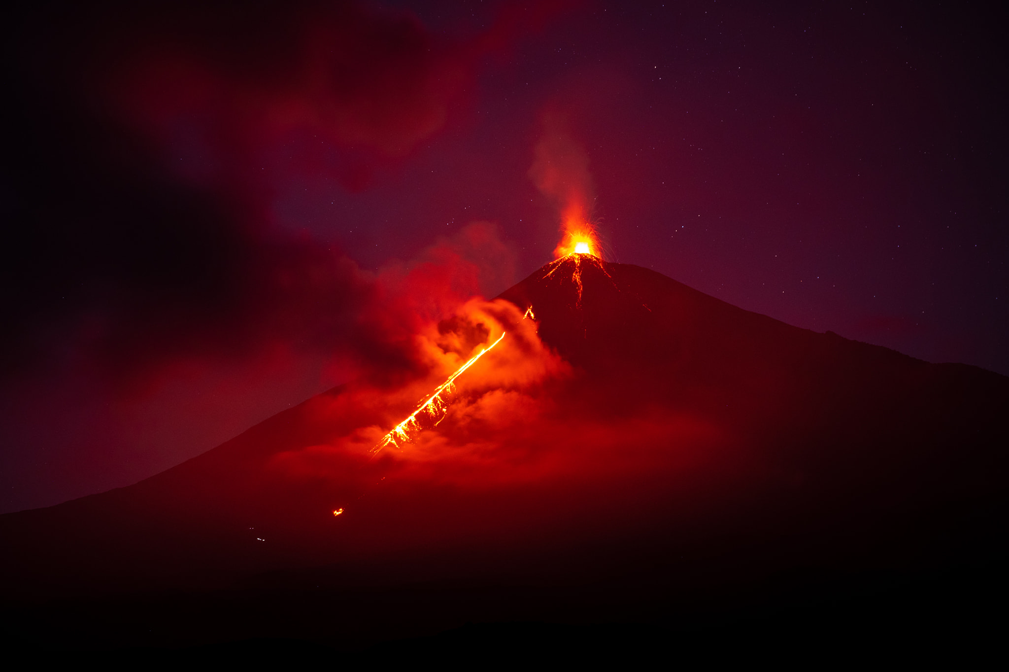
Guatemala , Fuego :
SPECIAL VOLCANOLOGICAL BULLETIN, March 7, 2022, 9:56 p.m. local time.
UPDATE ON THE STROMBOLIAN ERUPTION
Following the eruption of the Fuego volcano and the special bulletin, it is reported that during the last hours the seismic parameters have recorded an increase in activity greater than that observed during the last 24 hours. This results in increased amounts of pyroclastic fluxes, incandescence and ash fall. Sounds identical to those of locomotives and aircraft turbines continue to be moderate and the smell of sulfur is reported near the volcanic edifice. In the last hours, the atmospheric conditions in the upper part of the volcanic edifice have been favorable to observe that the descent of the pyroclastic flows continues towards the Barranca Ceniza and that it also extends to other flanks of the volcano, in this case moderate avalanches and possibly weak pyroclastic flows towards the Barranca Las Lajas.
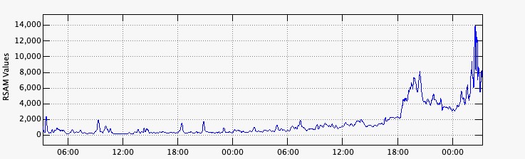
FIGURE 1. Graph of the last hours of seismic activity, recorded at station FG16.
It is not excluded that new lava flows are generated towards other ravines, as well as violent explosions loaded with ash and continuously generating more pyroclastic flows towards one of the ravines of the Fuego volcano, which is why it does not should not stay near or inside the canyons of the volcano.
INSIVUMEH maintains visual and instrumental monitoring of volcanic activity through seismic stations, volcano observers and web cameras.
Activity:
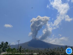
The Fuego volcano observatory reports an incandescent source 100 to 200 meters above the crater, periods of constant degassing and two lava flows in the direction of the Ceniza ravine and the Santa Teresa ravine with a length of 250 meters and 100 meters respectively, moderate to strong avalanches on the edge of the crater, towards the Ceniza and Trinidad ravines and weak and moderate in the direction of the Las Lajas and Santa Teresa ravines, several of them reaching the edge of the vegetation. The eruptive column is located at a height of 4900 meters above sea level (16076 feet) dispersing in a southwest and west direction over a distance of 20 kilometers, 10 to 15 weak and moderate rumblings per hour are reported with weak waves shock that vibrate the ceilings and windows of houses near the volcano. Ash falls are reported in the communities of Panimaché I, Panimaché II, Morelia, Santa Sofía, Yucales, El Porvenir and others in this direction. The volcano is in a high effusive stage, so the recommendations given in the BEFGO bulletin 006-2022 are still active.
Source : Insivumeh.
Photo : Diego Rizzo Photo .
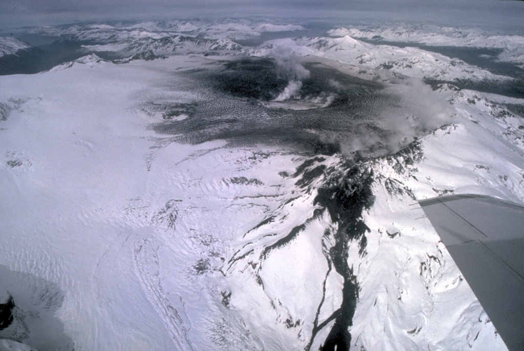
Chile , Hudson :
Special Report on Volcanic Activity (REAV), De Aysén Del General Carlos Ibanez Del Campo region, Hudson volcano, March 06, 2022, 7:50 p.m. local time (mainland Chile).
The National Service of Geology and Mines of Chile (Sernageomin) publishes the following PRELIMINARY information, obtained through the monitoring equipment of the National Volcanic Monitoring Network (RNVV), processed and analyzed at the Volcanological Observatory of the Southern Andes ( Ovdas):
On Sunday March 06, 2022, at 6:49 p.m. local time (21:49 UTC), the monitoring stations installed near the Hudson volcano recorded an earthquake associated with both rock fracturing and fluid dynamics (hybrid type) in the volcanic system.
The characteristics of earthquakes after their analysis are as follows:
ORIGINAL TIME: 6:49 p.m. local time (9:49 p.m. UTC).
LATITUDE: 45.958°S
LONGITUDE: 72.966°W
DEPTH: 5.2 km
REDUCED DISPLACEMENT: 1101.8 cm2
COMMENTS:
After the reported event, lower energy seismic activity continues to be recorded. The weather conditions in the area do not allow seeing the volcanic building.
The volcanic technical alert remains at the Green level.
Source : Sernageomin.
Photo : Norm Banks, 1991 (U.S. Geological Survey).
Peru , Sabancaya :
Analysis period: from February 28, 2022 to March 06, 2022, Arequipa, March 07, 2022.
Alert level: ORANGE
The Geophysical Institute of Peru (IGP) reports that the eruptive activity of the Sabancaya volcano remains at moderate levels, that is to say with the recording of an average of 15 daily explosions, with columns of ash and of gas up to 1.0 km altitude above the summit of the volcano and their subsequent dispersion. Therefore, for the following days, no significant change is expected in eruptive activity.
The IGP recorded and analyzed the occurrence of 108 earthquakes of volcanic origin, associated with the circulation of magmatic fluids inside the Sabancaya volcano. An average of 15 explosions was recorded daily. During this period, Volcano-Tectonic (VT) type earthquakes associated with rock fracturing were located mainly in the northeast and northwest of Sabancaya and presented magnitudes of M 2.5.
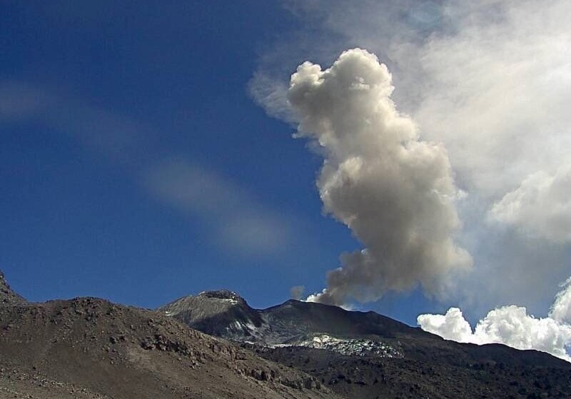
Monitoring the deformation of the volcanic structure using GNSS techniques (processed with fast orbits) does not show any significant anomalies. However, in general, an inflation process was observed in the northern sector (surroundings of the Hualca Hualca volcano). Visual surveillance identified columns of gas and ash up to 1.0 km above the summit of the volcano, which were dispersed towards the western, southern and southwestern sectors of Sabancaya. Satellite recordings have identified the presence of 2 thermal anomalies, with a maximum value of 14 MW, associated with the presence of a lava body on the surface of the volcano’s crater.
RECOMMENDATIONS
• Keep the volcanic alert level orange.
• Do not approach within a radius of less than 12 km from the crater.
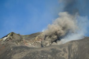
Source : CENVUL
Photo : Ingemmet
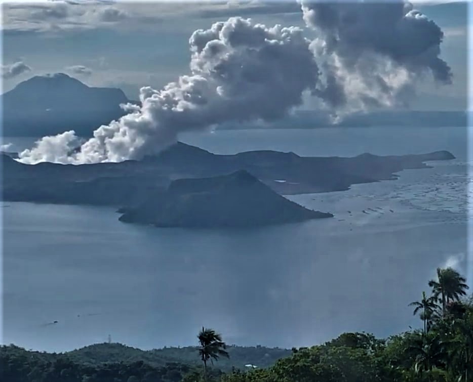
Philippines , Taal :
TAAL VOLCANO BULLETIN 08 March 2022 8:00 AM
In the past 24-hour period, the Taal Volcano Network did not detect any volcanic earthquake. Activity at the Main Crater was dominated by upwelling of hot volcanic fluids in its lake which generated plumes 900 meters tall that drifted southwest. Sulfur dioxide (SO2) emission averaged 7,695 tonnes/day on 07 March 2022. Temperature highs of 63.7°C were last measured from the Main Crater Lake on 25 February 2022. Based on ground deformation parameters from electronic tilt, continuous GPS and InSAR monitoring, Taal Volcano Island and the Taal region has begun deflating in October 2021.
Alert Level 2 (Increased Unrest) prevails over Taal Volcano. DOST-PHIVOLCS reminds the public that at Alert Level 2, sudden steam- or gas-driven explosions, volcanic earthquakes, minor ashfall, and lethal accumulations or expulsions of volcanic gas can occur and threaten areas within and around TVI. DOST-PHIVOLCS strongly recommends that entry into Taal Volcano Island, Taal’s Permanent Danger Zone or PDZ must be strictly prohibited, especially the vicinities of the Main Crater and the Daang Kastila fissure, and extended stays on Taal Lake.
Source : Phivolcs .
Photo : Kyle Aranza
Hawaii , Mauna Loa :
19°28’30 » N 155°36’29 » W,
Summit Elevation 13681 ft (4170 m)
Current Volcano Alert Level: ADVISORY
Current Aviation Color Code: YELLOW
Activity Summary:
Mauna Loa volcano is not erupting. Rates of seismicity remain slightly elevated above long-term background levels, but have not changed significantly over the past week. Other Mauna Loa monitoring data streams—ground deformation, gas concentrations, visual appearance in webcams—show no significant changes.

Observations:
During the past week, HVO seismometers recorded approximately 50 small-magnitude (below M2.5) earthquakes below the summit and upper-elevation flanks of Mauna Loa. The majority of these earthquakes occurred at shallow depths less than 10 kilometers (6 miles) below sea level.
Global Positioning System (GPS) measurements show very low rates of deformation in the summit region continuing through the past week.
Gas concentrations and fumarole temperatures at the summit and at Sulphur Cone on the Southwest Rift Zone remain stable.
Webcam views have shown no changes to the volcanic landscape on Mauna Loa over the past week.
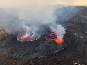
Source et photo: HVO.
Mexico , Popocatepetl :
March 07, 11:00 (March 07, 17:00 GMT)
In the past 24 hours, thanks to the monitoring systems of the Popocatépetl volcano, eight low intensity exhalations have been detected. In addition, episodes of low amplitude tremors were recorded which totaled 1,045 minutes, accompanied by emissions of water vapor, gas and sometimes slight amounts of ash. In addition, a volcano-tectonic earthquake was recorded today at 2:11 a.m., with a calculated magnitude of 1.2.
During the morning and at the time of this report, an intermittent emission of steam and volcanic gases is observed, dispersing to the northwest.

Based on the various parameters that are being monitored, it is considered likely that ash emissions will continue to occur. Finally, some explosions could be recorded that do not exceed in intensity those already observed. These scenarios are considered in the yellow level of phase 2 of the volcanic alert traffic light.
CENAPRED urges NOT TO APPROACH the volcano and especially the crater, because of the danger of falling ballistic fragments and, in case of heavy rains, to stay away from the bottom of the ravines because of the danger of mudslides and of debris.
The Popocatépetl volcanic alert traffic light is in YELLOW PHASE 2.
Source : Cenapred .