April 07 , 2023 .
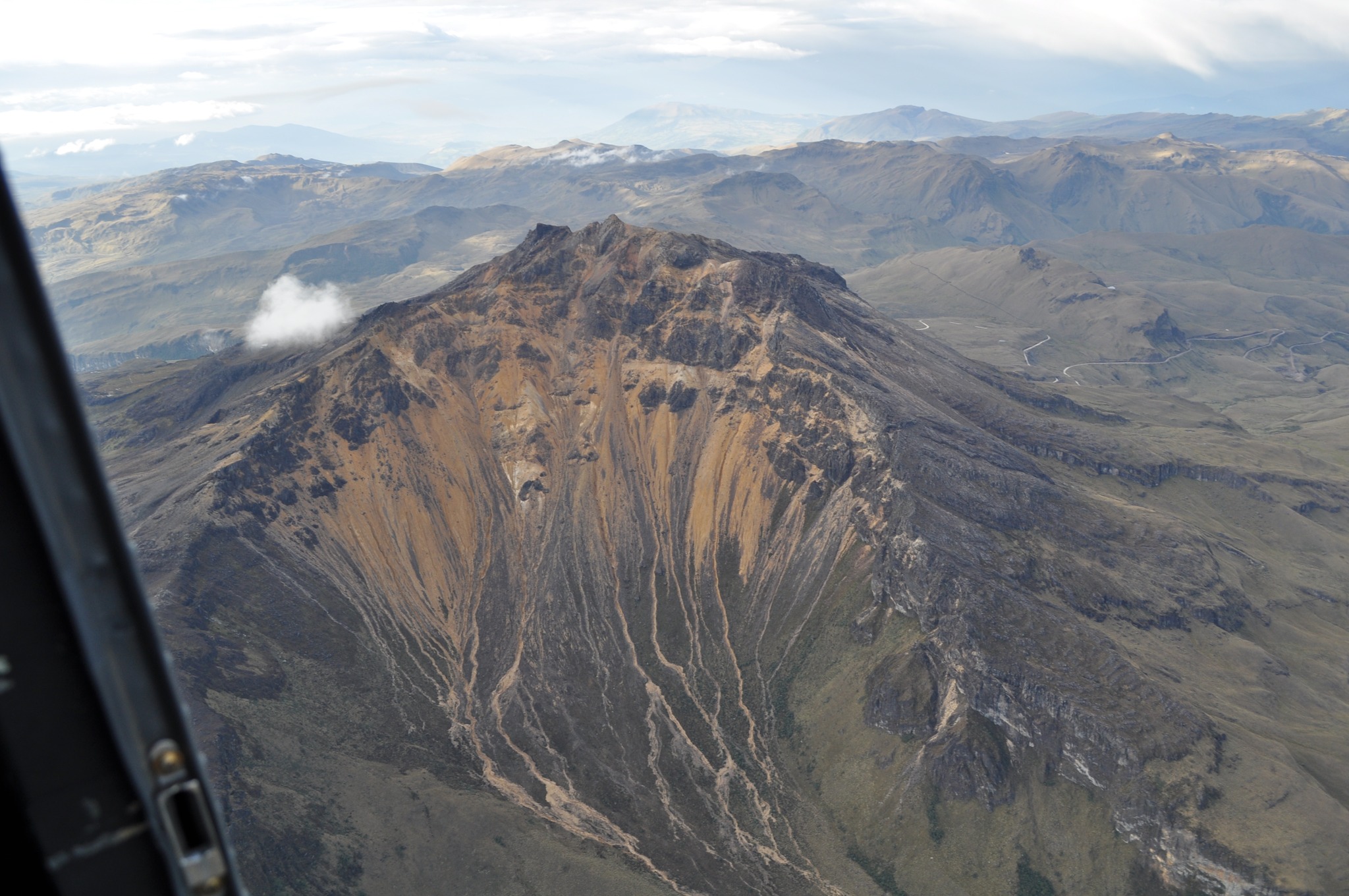
Colombia , Nevado del Ruiz :
Manizales, April 6, 2023 9:30 a.m.
Regarding the monitoring of the activity of the NEVADO DEL RUIZ VOLCANO, the MINISTRY OF MINES AND ENERGY through the COLOMBIAN GEOLOGICAL SERVICE (SGC) informs that:
The recording of seismicity associated with the fracturing of the rock inside the volcanic edifice continues. Yesterday April 5, 7100 events were recorded. This seismic activity continues to be located in the southwestern sector of the volcanic edifice at a distance from the crater of between 2 and 5 km, at depths of 3 to 4 km. From the afternoon, this seismic activity decreased compared to what was recorded during the first hours of the day and the maximum magnitudes reached reached 1.7 ML. So far today, April 6, 2023 (9 a.m.), about 800 earthquakes have been recorded.
The seismic activity related to the movement of fluids inside the volcanic conduits showed an increase compared to the previous day and was associated with various pulsatile and continuous emissions of ash which were confirmed by the web cameras used for volcanic monitoring. . The maximum height of the column of gas and / or ash observed was 1700 m measured from the summit of the volcano and the preferred direction of dispersion of the column was towards the South-West. Outgassing rates remained at levels similar to those seen the previous day. In addition, several thermal anomalies were reported.
It is important to emphasize that the activity of the volcano at LEVEL ORANGE can fluctuate and sometimes decrease compared to previous days, without this meaning that it has returned to a level of lower activity. To change the level and return to the yellow level, a prudential time is required where trends and patterns can be observed that allow us to deduce the possible decrease in activity, which is why it is warned that the level of activity of the Nevado del Ruiz volcano will remain at the ORANGE LEVEL for several weeks. Meanwhile, if there is an acceleration of processes suggesting an impending eruption or the eruption itself occurring, the activity level will turn red.
The community is recommended to remain calm and follow all instructions from the National Disaster Risk Management Unit (UNGRD) and local authorities, as well as to be attentive to the information provided by the Colombian Geological Service on the evolution of the state of the volcano.
The COLOMBIAN GEOLOGICAL SERVICE will continue to be attentive to the evolution of the volcanic phenomenon and will provide timely information on any changes that may occur.
The level of activity of the volcano remains at the ORANGE LEVEL of activity or (II): PROBABLE ERUPTION IN TERM OF DAYS OR WEEKS
Source et photo : SGC.
Colombia , Chiles / Cerro Negro :
Chiles and Cerro Negro Volcanic Complex (CVCCN) Weekly Activity Bulletin
Regarding the monitoring of the activity of the VOLCANOES CHILES AND CERRO NEGRO, the MINISTRY OF MINES AND ENERGY through the COLOMBIAN GEOLOGICAL SERVICE (SGC) informs that:
During the week between March 28 and April 3, 2023 and compared to what was reported the previous week, the activity in the region of the Chiles and Cerro Negro volcanoes showed an increase in both the occurrence and energy, going from 12020 to 18956 earthquakes.
Although in general there is a downward trend, seismicity continues at high levels, maintaining the predominance of earthquakes associated with the fracture of the rock, although earthquakes related to the movement of fluids within the volcanic system have also been recorded. This activity is always accompanied by a deformation of the surface of the CVCCN.
There were reports of five felt earthquakes, with magnitudes of 2.0; 2.5; 3.7; 3.9 and 3.1 on March 29 at 4:20 a.m. and 5:37 a.m.; April 1 at 11:02 p.m. and 11:11 p.m. and April 3 at 2:02 p.m. respectively, these events were reported as felt by the inhabitants of the Chiles Indigenous Reserve in the municipality of Cumbal – Nariño; In addition, the events of April 1 were reported as felt in the municipalities of Ipiales, Túquerres, Aldana and Cuaspud.
The possibility of earthquakes with greater energy that can be felt by the inhabitants of the area of influence is not excluded.
The activity level of the volcanoes remains at:
YELLOW LEVEL ■ (III): CHANGES IN THE BEHAVIOR OF VOLCANIC ACTIVITY.
Source et photo : SGC.
Japan , Satsuma Iwo Jima :
JMA reported that minor eruptive activity was recorded at Satsuma Iwo-jima, a subaerial part of Kikai’s NW caldera rim, during 27 March-3 April. White gas-and-steam plumes rose 700 m above the crater rim. Surveillance cameras observed nightly incandescence. The Alert Level remained at 2 (on a 5-level scale), and residents were warned to stay 500 m away from the crater.
![]()
Kikai is a mostly submerged, 19-km-wide caldera near the northern end of the Ryukyu Islands south of Kyushu. It was the source of one of the world’s largest Holocene eruptions about 6,300 years ago when rhyolitic pyroclastic flows traveled across the sea for a total distance of 100 km to southern Kyushu, and ashfall reached the northern Japanese island of Hokkaido. The eruption devastated southern and central Kyushu, which remained uninhabited for several centuries. Post-caldera eruptions formed Iodake lava dome and Inamuradake scoria cone, as well as submarine lava domes. Historical eruptions have occurred at or near Satsuma-Iojima (also known as Tokara-Iojima), a small 3 x 6 km island forming part of the NW caldera rim. Showa-Iojima lava dome (also known as Iojima-Shinto), a small island 2 km E of Tokara-Iojima, was formed during submarine eruptions in 1934 and 1935. Mild-to-moderate explosive eruptions have occurred during the past few decades from Iodake, a rhyolitic lava dome at the eastern end of Tokara-Iojima.
Source : Agence météorologique japonaise (JMA), GVP.
Source : Ray Go.
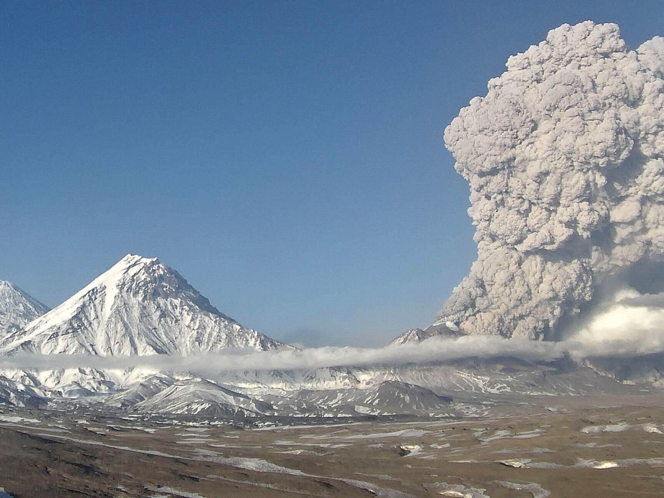
Kamchatka , Bezymianny :
VOLCANO OBSERVATORY NOTICE FOR AVIATION (VONA)
Issued: April 07 , 2023
Volcano: Bezymianny (CAVW #300250)
Current aviation colour code: RED
Previous aviation colour code: orange
Source: KVERT
Notice Number: 2023-48
Volcano Location: N 55 deg 58 min E 160 deg 35 min
Area: Kamchatka, Russia
Summit Elevation: 2882 m (9452.96 ft)
Volcanic Activity Summary:
Volcanic ash emission gradually increased. Probably, a new block of lava is squeezed out on the lava dome, it’s accompanied by ash explosions and hot avalanches. Satellite data by KVERT showed an ash plume extended about 230 km to the east-south-east from the volcano.
An eruption of the volcano continues. Ash explosions up to 10-15 km (32,800-49,200 ft) a.s.l. could occur during next several days. Ongoing activity could affect international and low-flying aircraft.
Volcanic cloud height:
5000-5500 m (16400-18040 ft) AMSL Time and method of ash plume/cloud height determination: 20230407/0400Z – Video data
Other volcanic cloud information:
Distance of ash plume/cloud of the volcano: 230 km (143 mi)
Direction of drift of ash plume/cloud of the volcano: ESE / azimuth 103 deg
Time and method of ash plume/cloud determination: 20230407/0320Z – Himawari-9 14m15
Source et photo : Kvert.
Chile , Lascar :
Special Report on Volcanic Activity (REAV) Antofagasta Region, Láscar Volcano, April 6, 2023, 7:30 p.m. local time (mainland Chile)
The National Geology and Mining Service of Chile (Sernageomin) discloses the following information, obtained through the monitoring equipment of the National Volcanic Monitoring Network (RNVV), processed and analyzed at the Observatory of Volcanoes of the Southern Andes ( Ovdas):
After the recording of energetic seismicity and the establishment of the lava dome housed in the active crater at the end of January 2023, the analyzes obtained from multi-parameter data (seismological, geodetic, geochemical and remote sensing) suggest that after nearly 2 months of observation, activity returned to low energy levels, but still above its baseline monitoring threshold.
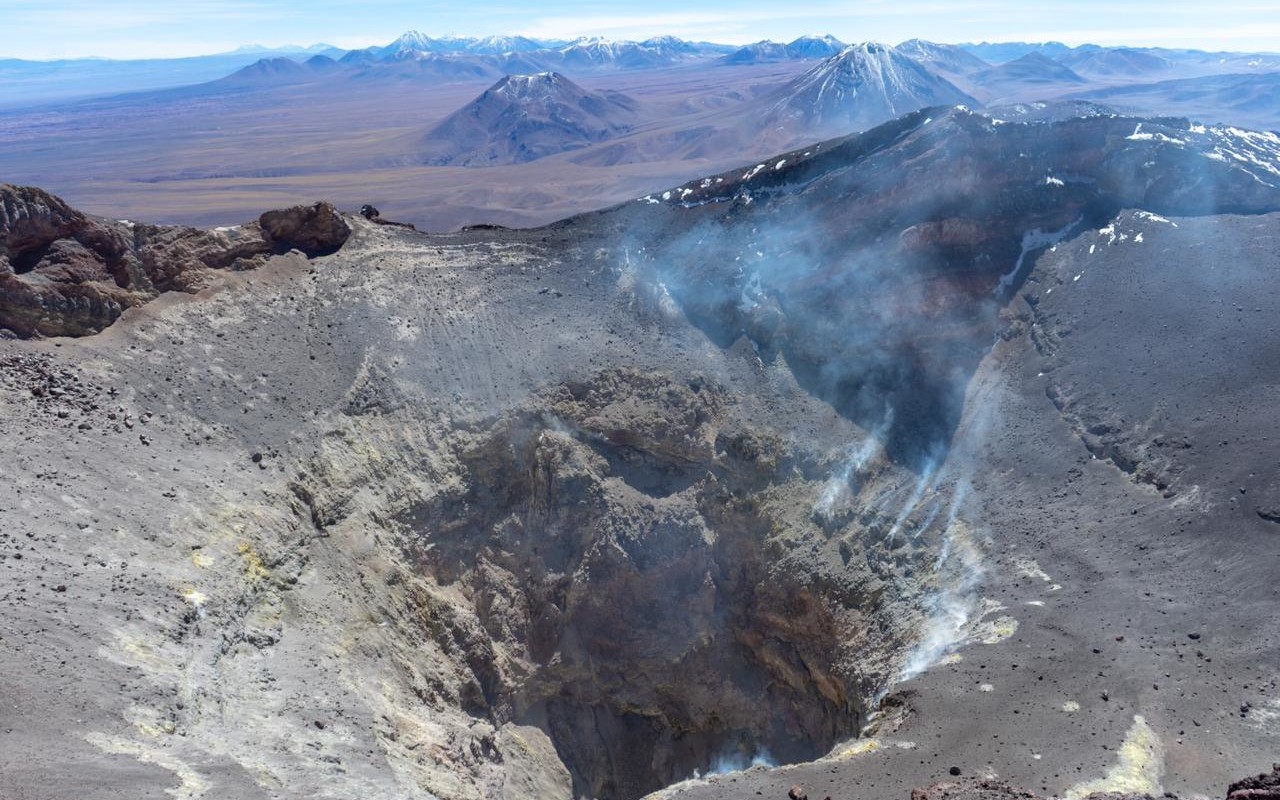
The particular aspects, such as a volcano-tectonic seismicity and of the « tornillos » type with little recursiveness, a weak or null evolution of the volume of the dome, a development of gas columns at low pressure with the absence or at low content of particulate matter, and a low content of SO2 concentrations, suggest the stagnation of an eruptive process whose progression has so far reached a certain equilibrium.
Despite the above, it should be remembered that the evolution of the activity is conditioned by the presence of a lava dome on the surface, where different scenarios would be expected, which could induce a sudden or progressive explosive activity. As a result, the technical alert level has changed to Yellow, and permanent monitoring of the activity is maintained, with a possible assignment zone with a radius of 5 km around the active crater.
Source : Sernageomin .
Photo : Vulcanopro.