March 08 , 2023.
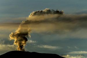
Alaska , Tanaga :
AVO/USGS Volcanic Activity Notice
Current Volcano Alert Level: ADVISORY
Previous Volcano Alert Level: NORMAL
Current Aviation Color Code: YELLOW
Previous Aviation Color Code: GREEN
Issued: Tuesday, March 7, 2023, 10:15 PM AKST
Source: Alaska Volcano Observatory
Notice Number: 2023/A266
Location: N 51 deg 53 min W 178 deg 8 min
Elevation: 5925 ft (1806 m)
Area: Aleutians
Volcanic Activity Summary:
Earthquake activity beneath Tanaga Volcano began to increase slowly starting at about 1:30 PM AKST today. At roughly 8:45 PM AKST this evening, the activity escalated with earthquakes occurring as often as 2 or 3 each minute. Initial locations of these earthquakes place them at shallow depths beneath the summit of Tanaga Volcano, and the largest of these earthquakes have magnitudes between 2 and 3. In response to this increase in seismicity, we are raising the Aviation Color Code to YELLOW and the Volcano Alert Level to ADVISORY.
Tanaga Volcano is monitored with a local seismic and infrasound network, regional infrasound and lightning detection networks, and satellite data.
Remarks:
Tanaga Island lies in the Andreanof Islands approximately 100 km (62 miles) west of the community of Adak and 2025 km (1260 miles) SW of Anchorage. The northern half of the island is home to the Tanaga volcanic complex, comprising three main volcanic edifices. Tanaga Volcano is the tallest of these (1,806 m or 5,925 ft) and lies in the center of the complex. The last reported eruption of Tanaga occurred in 1914 and earlier eruptions were reported in 1763-1770, 1791, and 1829. Reports of these eruptions are vague, but deposits on the flanks of the volcano show that typical eruptions produce blocky lava flows and occasional ash clouds. Eruptions have occurred both from the summit vent and a 1,584 m (5,197 ft)-high satellite vent on the volcano’s northeast flank. Immediately west of Tanaga volcano lies Sajaka, a 1,354 m (4,443 ft)-high compound edifice with an older cone to the east that collapsed into the sea within the last few thousand years, and a new cone that has grown in the breach. The new cone is 1,312 m (4,305 ft) high and consists of steeply dipping, interbedded cinders and thin, spatter-fed lava flows. To the east of Tanaga lies Takawangha, which is separated from the other active volcanic vents by a ridge of older rock. Takawangha’s 1,449 m (4,754 ft)-high summit is mostly ice-covered, except for four young craters that have erupted ash and lava flows in the last few thousand years. Parts of Takawangha’s edifice are hydrothermally altered and may be unstable, and could produce localized debris avalanches. No historical eruptions are known from Sajaka or Takawangha; however, field work shows that recent eruptions have occurred and it is possible that historic eruptions attributed only to Tanaga may instead have come from these other vents.
Source : AVO.
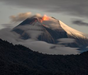
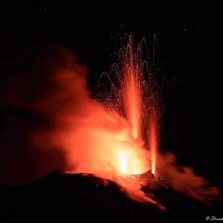
Italy , Stromboli :
Weekly bulletin, from February 27, 2023 to March 05, 2023. (Issue date March 07, 2023)
Activity status summary.
In the light of monitoring data, it is highlighted:
1) Volcanological observations: During this period, normal Strombolian activity was observed with spattering and lava flow activities from the North Crater area. The total hourly frequency oscillated between low average values (8 events/h) and average values (11 events/h). The intensity of the explosions was mainly medium and low in the North crater area and medium in the South Center crater area.
2) Seismology: the monitored seismological parameters do not show significant variations.
3) Ground Deformations: Island ground deformation monitoring networks showed no significant variation to report for the period in question.
4) Geochemistry: SO2 circulates at an average level
The CO2 fluxes do not show any significant variations and are at average values.
The C/S values are at average values.
Isotope relationship of dissolved helium in heat sinks: there are no updates.
5) Satellite Observations: The thermal activity observed by satellite was generally low level, but on February 27, 2023, moderate thermal flow values were recorded in correspondence with an overflow of lava in the upper zone.
Volcanological observations
During the period subject to observation, the eruption activity of Stromboli was characterized by the analysis of the images recorded by the surveillance cameras of 190m (SCT-SCV), Punta Dei Corvi, while the cameras del Pizzo and 400 m are not currently available. The explosive activity was produced, mainly, by 2 (two) eruptive vents located in the North crater area and at least 2 (two) vents located in the South Center crater area.
On February 27, 2023, two lava flows were produced by the North Crater region.
Due to a technical problem, the SCT and SCV cameras were discontinued from 19:50 UTC on March 2 to 06:56 on March 5, while the SPCT camera was still functional. Due to the unfavorable weather conditions, the visibility of the crater area was insufficient for a correct description of the eruptive activity.
Observations of explosive activity observed by surveillance cameras:
In the region of the North crater (N), from the two mouths of sectors N1 and N2, an explosive activity of variable intensity from low (less than 80 m in height) to medium (less than 150 m in height) with l emission of coarse materials (bombs and lapilli)). In addition, splashing activity was observed in the N1 sector which was intense for short periods on February 27 and 28. The average frequency of explosions fluctuated between 2 and 6 events/h.
In the Center-South region (CS) only by sector S2, an explosive activity of medium intensity was observed (sometimes the products exceeded 150 high), with the emission of coarse materials. The average frequency of explosions varied between 3 and 6 events/h.
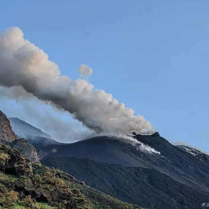
Lava flows of February 27, 2023.
On February 27, 2023, sector N2 of the northern crater area produced two lava flows described below.
At 05:57:06, the first overflow from the mouth of sector N2 began. The lava emission was composed of two lava flows; The first, volumetrically larger, sank inside the ravine formed on October 9, 2022, while the second flowed in a direction parallel and further south of the first. At 6:00 p.m., both streams appeared to have lost power.
At 8:49:00 p.m., a second event begins, less powered than the first, which overlapped the flows of the first overflow. This second flow no longer seemed to be fed at
00:50 on February 28. Material broke off from the two lava flows and rolled along the Sciara and only a modest part, not very visible by the SPCT camera, reached the coast.
Source : INGV.
Photos : Stromboli stati d’animo
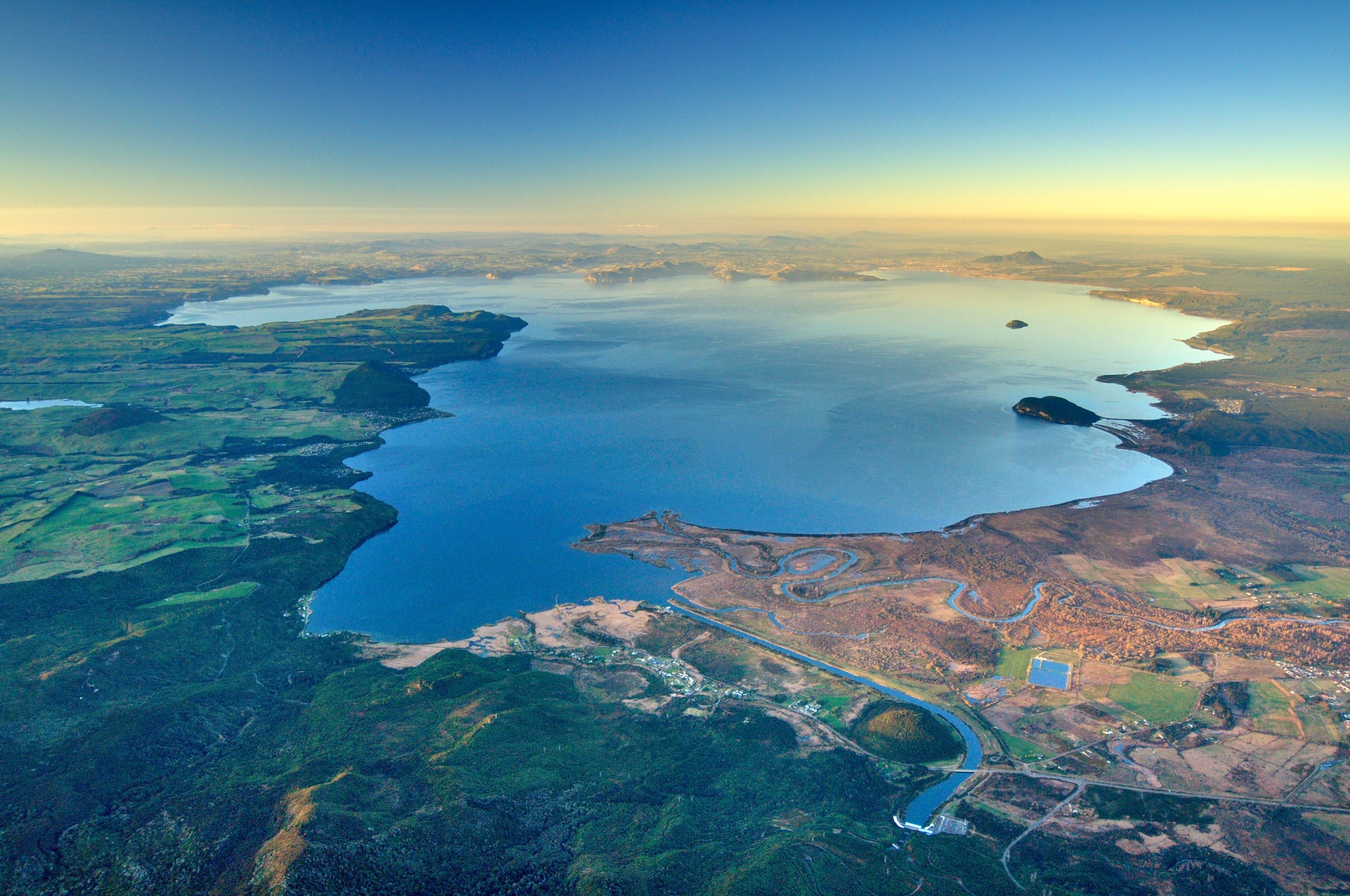
New Zealand , Lake Taupo :
Minor unrest continues at Taupō Volcano including a recent M4.4 earthquake.
Volcanic Alert Level remains at 1
Aviation Colour Code remains at Green
On Sunday 5 March 2023, GeoNet recorded an M4.4 earthquake beneath Lake Taupō. The earthquake rupture occurred within 10 km of the surface and shaking was felt mostly along the lake shore. So far, more than 20 aftershocks have been located.
The number of earthquakes per week has been declining since November, but we have seen a slight increase prior to Sunday’s quake (Figure 1). We also noticed a small signal on our newly installed tsunami sensors in the lake at the time of the earthquake, but more analysis is required to find out its cause.

Figure 1: Number of earthquakes detected and located by the GeoNet network beneath Lake Taupō each week since the start of 2022.
The recent number and size of earthquakes, including the M4.4 event, is within our expectations for a volcano at minor volcanic unrest. This is confirmed by our other observations to date which show continuous activity, but no significant changes compared to the previous months of unrest. We also did not notice any changes in volcano monitoring indicators following the M4.4 earthquake. Therefore, the Volcanic Alert Level remains at 1 at Taupō volcano, and the Aviation Colour Code at green
GNS Science continues to actively monitor the volcano and engage with national and international experts to provide the best possible interpretation of our monitoring data.
The Volcanic Alert Level reflects the current level of volcanic unrest or activity and is not a forecast of future activity. While Volcanic Alert Level 1 is mostly associated with environmental hazards, potential for eruption hazards also exists.
Source : Geonet / Yannik Behr
Photos : Geonet
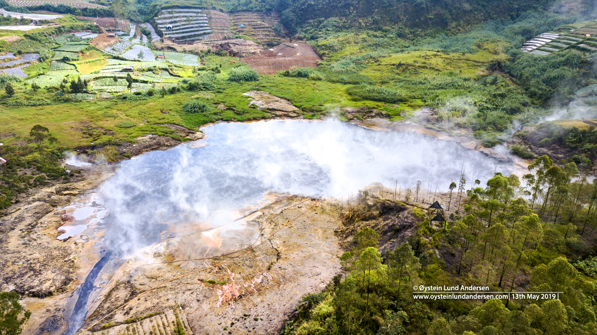
Indonesia , Dieng Plateau :
Decreased G. Dieng’s activity level from Tier II (Waspada) to Tier I (Normal).
Instrumental
In the period from January 14, 2023 to March 5, 2023, there were:
1 deep volcanic earthquake with an amplitude of 18.7 mm, and a duration of 5.5 seconds.
1219 local tectonic earthquakes with an amplitude of 4.3-42.7 mm, and a duration of 4.32-57.03 seconds.
32 earthquakes felt, scale I to II to III MMI with an amplitude of 42.7 mm, and a duration of 9.8 to 202.91 seconds.
13 distant tectonic earthquakes with amplitudes of 9.3 to 42.7 mm, and durations of 43.2 to 246.8 seconds.
Risk and potential assessment
Visually, the accumulation of smoke in the Crater Timbang has decreased, the low pressure indicates that the contribution of volcanic gases, in particular CO2, has decreased. The results of the measurement of the CO2 gas concentration in the Timbang Crater on February 22, 2023 using a multigas detector was recorded at 11.2% Vol. And at less than 10 meters away, the maximum CO2 concentration is 0.92%Vol. While the measurement results of the multigas station, the CO2 concentration is between 0.15% -0.19%vol. This indicates a decrease in the concentration of CO2 gas in the Crater Timbang. The results of water temperature and soil temperature measurements in the Sileri crater at the same time, with an average of 67.3°C and 22.1°C respectively, show a relatively stable temperature.
Local tectonic earthquakes and felt earthquakes show a decrease, indicating that subsurface conditions have begun to stabilize.
The potential danger that can arise from volcanic activity on G. Dieng at present is mainly phreatic eruptions in the Sileri crater. Phreatic eruptions or mudslides in the Sileri crater can occur without being preceded by an increase in visual and seismic activity.
Conclusions and Recommendations
Based on the results of a thorough assessment and the current hazard potential, the activity level of G.Dieng has been reduced from Level II (Waspada) to Level I (Normal) effective March 6, 2023 at 4:00 p.m. WIB with recommendations adjusted to the latest potential threats of danger. The activity level of G. Dieng can be reassessed if there is a significant change in activity visually and instrumentally.
Source: PVMBG.
Photo : Sileri , Dieng-Plateau, Øystein Lund Andersen
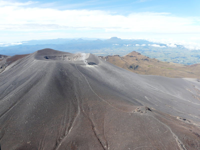
Colombia , Purace – Los Coconucos Volcanic Range :
Weekly Activity Bulletin: Puracé Volcano – Los Coconucos Volcanic Range:
The level of activity of the volcano continues at the Yellow activity level or (III): changes in the behavior of volcanic activity.
From the analysis and evaluation of the information obtained through the monitoring network of the Puracé volcano – volcanic chain of Los Coconucos: during the week between February 28 and March 6, 2023, the Colombian Geological Service – Volcanological Observatory of Popayan reports that:
• During the week evaluated, there were a total of 897 seismic events, of which 113 were associated with rock fracturing processes (type VT) and 784 with fluid dynamics in volcanic channels. The recording of two episodes of hybrid type events (associated with rock fracturing and fluid dynamics) on March 4 and 5 with periods of 10 and 20 minutes, respectively, with an approximate rate of 15 earthquakes per minute.
• The GNSS station network for ground deformation monitoring continues to record a process associated with inflation.
• By monitoring the surface activity with the images obtained during the week through the Mina, Lavas Rojas y Cerro Sombrero cameras, the degassing of the volcanic system was highlighted, with a white column oriented preferentially towards the North- West.
• Volcanic gas monitoring presented a maximum flow of 432 T / day for SO2 and a concentration greater than 10,000 ppm for CO2, values relevant in the degassing process of this volcanic system.
• Electromagnetic field and infrasound wave monitoring sensors did not record variations associated with changes in volcanic activity.
In conclusion, the variations in volcanic activity continue with the behaviors expected at the level of level III activity (yellow level), which could evolve towards states of greater activity.
Source et photo : SGC.
Hawaii , Kilauea :
Tuesday, March 7, 2023, 8:30 AM HST (Tuesday, March 7, 2023, 18:30 UTC)
19°25’16 » N 155°17’13 » W,
Summit Elevation 4091 ft (1247 m)
Current Volcano Alert Level: WATCH
Current Aviation Color Code: ORANGE
Activity Summary:
The summit eruption of Kīlauea Volcano, within Halemaʻumaʻu crater, has paused. Lava is no longer flowing on the crater floor, where all recent eruptive activity has been confined. No significant changes have been observed along either of the volcano’s rift zones.
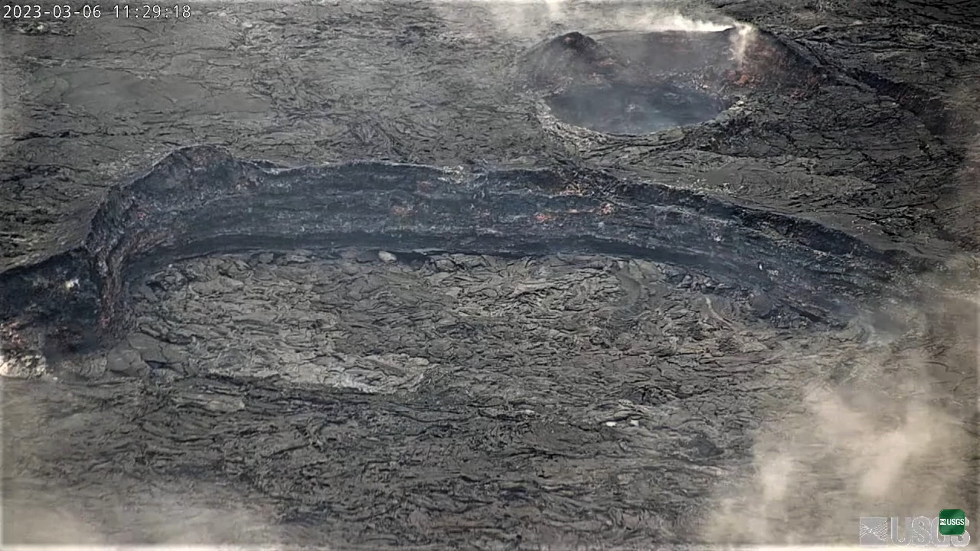
Halemaʻumaʻu Crater Observations:
Yesterday morning, small ooze-outs of lava were flowing sluggishly in the footprint of the inactive western lava lake, within the basin that remained from the end of the 2021–2022 eruption. Ooze-out activity diminished in the afternoon, and today no active lava has been observed in Halemaʻumaʻu crater. Monitoring data also suggest that no new lava is being emplaced under the crusted crater floor, but it is possible that previously accumulated lava may feed further ooze-outs at the surface. Several hornitos on the crater floor are still glowing in overnight webcam views, but these are not erupting any lava. The recent reduction in activity is related to a large deflationary tilt signal that began on February 17.
Summit Observations:
Following a large deflationary tilt signal that began on February 17 and lasted until early February 19, summit tiltmeters have tracked several smaller deflation/inflation (DI) events. Over the course of these DI events there has been a slight increase in net tilt, but the summit remains deflated compared to the period leading up to February 17. Eruptive activity on the Halemaʻumaʻu crater floor may resume if the summit re-inflates to the prior level. Volcanic tremor has dropped slightly in recent weeks, approaching background level. A sulfur dioxide (SO2) emission rate of approximately 250 tonnes per day (t/d) was measured on February 28.
Source et photo : HVO