March 03 , 2023.
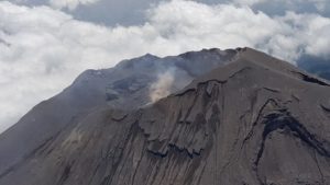
La Réunion , Piton de la Fournaise :
In February 2023, the OVPF-IPGP recorded at the level of the Piton de la Fournaise massif in total:
• 16 superficial volcano-tectonic earthquakes (0 to 2.5 km above sea level) under the summit craters;
• 5 deep earthquakes (below sea level);
• 20 long-period type earthquakes;
• 518 landslides.
The month of February 2023 will have been marked by low seismicity at the level of Piton de la Fournaise with an average of 0.5 superficial volcano-tectonic earthquake per day. Most of these events were located under the eastern rim of the Dolomieu crater.
The deep earthquakes were located under the eastern flank of the volcano. The month of February will also have been marked by numerous landslides in the Cratère Dolomieu, at Cassé de la Rivière of the East and at the level of the flow of the eruption of September-October 2022.

Deformation
With the cessation of the last eruption on October 5, 2022, a resumption of inflation of the entire edifice was recorded until October 23 followed by a period without significant deformation of the edifice.
Between December 30, 2022 and January 3, 2023, a rapid inflation of the volcano was observed (with a dilation of the summit of about 1 cm max.), revealing a rapid pressurization of the superficial magmatic reservoir (located at 2-2.5 km below the summit). Following this inflation, a deflation of the summit area was observed in January. In February, no significant signal was recorded at the top, while weak and slow inflation was still recorded in the far field. The slow inflation in the far field could testify to the pressurization of a deep magmatic source (below sea level) and/or deep fluid circulations.
Source : OVPF.
Photo : Imaz Press
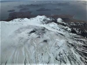
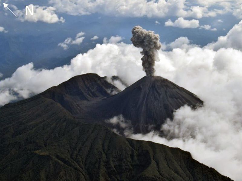
Vanuatu , Ambae / Lake Voui :
On 23 February the Vanuatu Meteorology and Geo-Hazards Department (VMGD) reported that the cone in Ambae’s Lake Voui continued to produce emissions consisting of steam, volcanic gases, and possibly occasional ash that drifted downwind. Volcanic earthquakes were recorded by the seismic network. The Alert Level remained at 2 (on a scale of 0-5) and the public was warned to stay outside of the Danger Zone, defined as a 2-km radius around the active vents in Lake Voui, and away from drainages during heavy rains.
The island of Ambae, also known as Aoba, is a massive 2,500 km3 basaltic shield that is the most voluminous volcano of the New Hebrides archipelago. A pronounced NE-SW-trending rift zone dotted with scoria cones gives the 16 x 38 km island an elongated form. A broad pyroclastic cone containing three crater lakes (Manaro Ngoru, Voui, and Manaro Lakua) is located at the summit within the youngest of at least two nested calderas, the largest of which is 6 km in diameter. That large central edifice is also called Manaro Voui or Lombenben volcano. Post-caldera explosive eruptions formed the summit craters about 360 years ago. A tuff cone was constructed within Lake Voui (or Vui) about 60 years later. The latest known flank eruption, about 300 years ago, destroyed the population of the Nduindui area near the western coast.
Source : GVP.
Photo : Air taxi vanuatu
Colombia , Nevado del Ruiz :
Bulletin of activity level of the Nevado del Ruiz volcano.
The activity level continues at the yellow activity level or (III): changes in the behavior of volcanic activity.
Regarding the monitoring of the activity of the Nevado del Ruiz volcano, the COLOMBIAN GEOLOGICAL SERVICE reports that:
Seismic activity associated with rock fracturing decreased in the number of earthquakes recorded and increased in seismic energy released compared to the previous week. The earthquakes were located mainly in the North-East, West-South-West and South-East sectors; to a lesser extent in the East, South-South-West and in the Arenas crater. Depths ranged from 0.9 to 6.1 km. Two seismic increases occurred on February 22 and 26, located in the North-East sectors for the first and South-East for the second; Additionally, earthquakes continued to occur in the West-Southwest sector, the location of the increase reported last week. The maximum magnitude calculated during the week, which was part of the increase on February 26, was 2.6 ML (Local Magnitude) corresponding to the earthquake recorded at 11:18 a.m. (local time), located 1.6 km to the East northeast of the Arenas crater, 3.6 km deep.
Seismic activity related to fluid dynamics inside volcanic conduits increased in the number of events recorded and in the seismic energy released compared to the previous week. According to images captured by cameras installed in the volcano area, several gas and ash emissions associated with some of the seismic signals have been confirmed.
The deformation of the volcanic surface continues to show minor changes.
Monitoring the volcano’s thermal activity, web portals have reported several low-energy thermal anomalies in Arenas Crater for this week.
Source et photo : SGC.
Hawaii , Kilauea :
Thursday, March 2, 2023, 7:55 AM HST (Thursday, March 2, 2023, 17:55 UTC)
19°25’16 » N 155°17’13 » W,
Summit Elevation 4091 ft (1247 m)
Current Volcano Alert Level: WATCH
Current Aviation Color Code: ORANGE
Activity Summary:
The summit eruption of Kīlauea Volcano, within Halemaʻumaʻu crater, continues at greatly reduced activity levels compared to several weeks ago. All recent eruptive activity has been confined to the crater. No significant changes have been observed along either of the volcano’s rift zones.

Halemaʻumaʻu crater Lava Lake Observations:
Eruption of lava on the Halemaʻumaʻu crater floor continues to be greatly diminished. The eastern and central vents that were active earlier in the eruption are not effusing any lava at this time. The western lava lake—within the basin of the 2021–2022 lava lake—remains active but with weak circulation; it is mostly crusted over, with intermittent crustal overturns. The reduction in activity is related to a large deflationary tilt signal that began on February 17.
Summit Observations:
Following a large deflationary tilt signal that began on February 17 and lasted until early February 19, summit tiltmeters have tracked several smaller deflation/inflation (DI) events. Over the course of these DI events there has been a slight increase in net tilt, but the summit remains deflated compared to the period leading up to February 17. More vigorous eruptive activity on the Halemaʻumaʻu crater floor may resume when the summit re-inflates to the prior level. Volcanic tremor has dropped slightly in recent weeks, but it remains above background level. A sulfur dioxide (SO2) emission rate of approximately 250 tonnes per day (t/d) was measured on February 28.
Source : HVO.
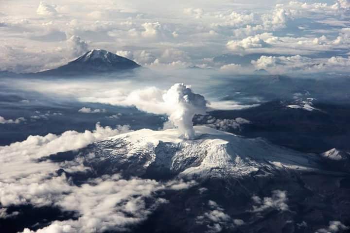
Ecuador , Reventador :
DAILY REPORT OF THE STATE OF THE REVENTADOR VOLCANO, Thursday March 02, 2023.
Information Geophysical Institute – EPN.
Surface activity level: Moderate, Surface trend: No changes
Internal activity level: Moderate, Internal trend: No change
Seismicity: From March 01, 2023, 11:00 a.m. to March 02, 2023, 11:00 a.m.:
There was no interruption in the transmission of data from the reference station for seismic statistics.
Explosion (EXP): 24
Long periods (LP): 28
Emission Tremors (TREMI): 8
Harmonic Tremor (TRARM): 5
Rains / Lahars:
No rain was recorded in the area.
Emission / Ash Column:
In the afternoon of yesterday, ash emissions could be observed up to 800 meters above the level of the crater and towards the northwest. The Washington VAAC reported 2 satellite-observed ash emission alerts up to 688 meters above crater level and heading northwest.
Observation:
Currently the area of the volcano is cloudy.
Alert level: Orange.
Source : IGEPN.
Photos : f-naranjo , GVP.