March 02 , 2023.
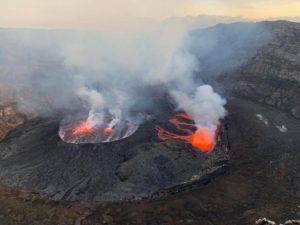
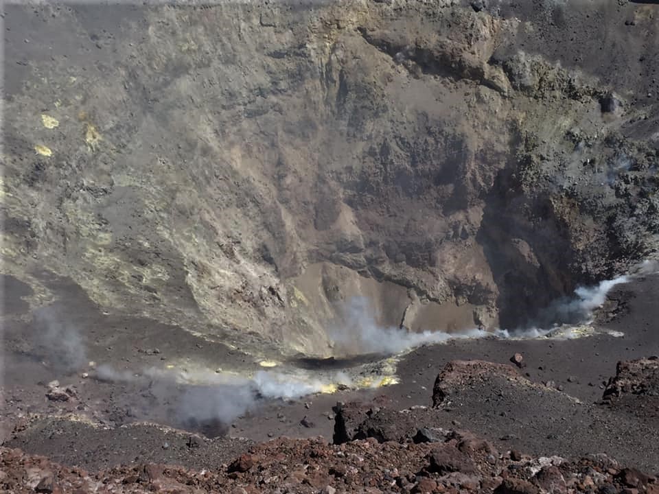
Democratic Republic of Congo , Nyiragongo :
The Observatoire Volcanologique de Goma (OVG) reported that the lava lake on Nyiragongo’s crater floor continued to be active during 13-19 February; faint glow emanated from the crater on 15 February. Seismicity was generally low, characterized by a few long-period earthquakes located up to 15 km deep along the large fracture connecting the Nyamuragira and Nyiragongo. A seismic station near the volcano registered a minor increase in the intensity of signals on 17 February. High concentrations of carbon dioxide were measured in the Mazuku areas, and in an area to the W of a camp in the Lac Vert district in Bulengo; OVG warned residents to stay away from those areas. The Alert Level remained at Yellow.

One of Africa’s most notable volcanoes, Nyiragongo contained a lava lake in its deep summit crater that was active for half a century before draining catastrophically through its outer flanks in 1977. The steep slopes of a stratovolcano contrast to the low profile of its neighboring shield volcano, Nyamuragira. Benches in the steep-walled, 1.2-km-wide summit crater mark levels of former lava lakes, which have been observed since the late-19th century. Two older stratovolcanoes, Baruta and Shaheru, are partially overlapped by Nyiragongo on the north and south. About 100 parasitic cones are located primarily along radial fissures south of Shaheru, east of the summit, and along a NE-SW zone extending as far as Lake Kivu. Many cones are buried by voluminous lava flows that extend long distances down the flanks, which is characterized by the eruption of foiditic rocks. The extremely fluid 1977 lava flows caused many fatalities, as did lava flows that inundated portions of the major city of Goma in January 2002.
Source : GVP.
Photo : 17 Avril 2019 , Nyiragongo expedition
United-States , Yellowstone :
Wednesday, March 1, 2023, 9:30 AM MST (Wednesday, March 1, 2023, 16:30 UTC)
44°25’48 » N 110°40’12 » W,
Summit Elevation 9203 ft (2805 m)
Current Volcano Alert Level: NORMAL
Current Aviation Color Code: GREEN
Recent Work and News
There were no recorded eruptions of Steamboat Geyser during the month of February, and the total number of eruptions for the year remains at two. The Norris temperature monitoring network and seismic station YNM have been inaccessible since mid to late February due to a local power failure—the Norris Museum is difficult to access during winter months—but the streamgage on Tantalus Creek, through which all water from Norris Geyser Basin drains, did not record obvious spikes that would be associated with Steamboat eruptions.
Seismicity
During February 2023, the University of Utah Seismograph Stations, responsible for the operation and analysis of the Yellowstone Seismic Network, located 168 earthquakes in the Yellowstone National Park region. The largest event of the month was a minor earthquake of magnitude 2.9 located about 11 miles northeast of West Yellowstone, Montana, on February 7 at 8:44 PM MST. This event was part of a swarm of 76 earthquakes that occurred in the area during February 4–11.
In addition, 48 earthquakes were added to the ongoing seismicity that began last summer about 14 miles south-southwest of Mammoth Hot Springs in Yellowstone National Park. The largest earthquake of the month in this sequence, a magnitude 2.4 event, occurred on February 14 at 3:03 AM MST.
Earthquake sequences like these are common and account for roughly 50% of the total seismicity in the Yellowstone region.
Yellowstone earthquake activity is currently at background levels.
Ground Deformation
Continuous GPS stations in Yellowstone Caldera continued to record gradual subsidence at a rate of several centimeters (about 1 inch) per year, which has been ongoing since 2015. No significant deformation has been recorded in the area of Norris Geyser Basin since the end of last summer. Snow and ice accumulation on GPS antennas due to winter storms cause occasional apparent subsidence of 1–3 centimeters, but this does not represent real ground motion and recovers itself quickly once the antennas are free of snow/ice.
Source : YVO.
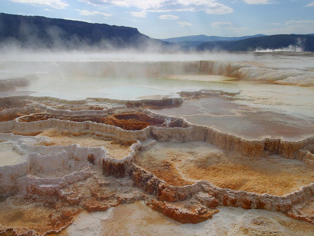
Photo : Mammoth hot spring , Jon Sullivan /wikipedia
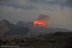
Chile , Lascar :
Yellow alert level monitoring for the municipality of San Pedro de Atacama due to the activity of the Láscar volcano
According to information provided by the Volcanic Observatory of the Southern Andes (OVDAS) of the National Service of Geology and Mines (SERNAGEOMIN), the Láscar volcano maintains its technical alert level in Orange.
Regarding the latest special report on volcanic activity (REAV), it is indicated that today, Wednesday March 1 at 7:05 p.m., the monitoring stations installed near the Láscar volcano recorded an earthquake of the type « Tornillo » (TO). associated with the resonance of fluid interaction within the volcanic system.
The characteristics of the earthquake, after its analysis, are as follows:
Original time: 7:05 p.m. local time.
Reduced displacement: 86.7 cm 2
After this event, no change is observed in the seismic behavior of the volcano, nor is any surface activity associated with the event recorded.
In consideration of this technical training provided by SERNAGEOMIN and in coordination with the Regional Presidential Delegation of Antofagasta, the Regional Directorate of SENAPRED maintains the Yellow Alert, for the municipality of San Pedro de Atacama, due to the activity of the Volcano Láscar, which has been in force since January 26.
For its part, the SERNAGEOMIN maintains the hazard zoning, considering a radius of 10 kilometers around the center of the active crater of the volcano as a probable zone affected by volcanic products. While SENAPRED maintains a security perimeter within a radius of 10 kilometers, around the crater of the Láscar volcano, in order to prevent access to the sector.
Finally, the SERNAGEOMIN continues the permanent monitoring of the volcano online and the Regional Directorate of SENAPRED will maintain coordination with the members of the Regional System for Prevention and Response to Disasters to alert in a timely manner and provide an adequate response to possible emergency situations. resulting from the volcanic state.
Source : SENAPRED.
Photo : Eric Jo ( 2019).
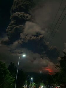
Japan , Sakurajima :
JMA reported ongoing eruptive activity at Minamidake Crater and Showa Crater (at Aira Caldera’s Sakurajima volcano) during 13-20 February and incandescence at both craters was visible nightly. Very small eruptive events occurred at Showa Crater. Three explosions and three or four eruptive events were recorded at Minamidake Crater during the week. Volcanic plumes rose as high as 1.5 km above the Minamidake Crater rim and large blocks were ejected 600-900 m from the vent. During an overflight on 21 February scientists observed white plumes rising from a vent on the N inner crater wall at Showa Crater and they noted more voluminous emissions compared to the 12 October 2022 overflight. No notable changes at Minamidake Crater were observed. At 1230 on 26 February an eruptive event at Minamidake Crater produced a plume that rose 1.2 km above the crater rim. The Alert Level remained at 3 (on a 5-level scale), and residents were warned to stay 2 km away from both craters.
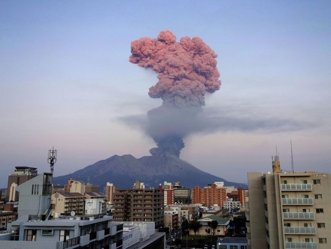
The Aira caldera in the northern half of Kagoshima Bay contains the post-caldera Sakurajima volcano, one of Japan’s most active. Eruption of the voluminous Ito pyroclastic flow accompanied formation of the 17 x 23 km caldera about 22,000 years ago. The smaller Wakamiko caldera was formed during the early Holocene in the NE corner of the Aira caldera, along with several post-caldera cones. The construction of Sakurajima began about 13,000 years ago on the southern rim of Aira caldera and built an island that was finally joined to the Osumi Peninsula during the major explosive and effusive eruption of 1914. Activity at the Kitadake summit cone ended about 4850 years ago, after which eruptions took place at Minamidake. Frequent historical eruptions, recorded since the 8th century, have deposited ash on Kagoshima, one of Kyushu’s largest cities, located across Kagoshima Bay only 8 km from the summit. The largest historical eruption took place during 1471-76.
Source : GVP
Photo : Deniss García Mendoza
Colombia , Cerro Machin :
Subject: Activity level bulletin of the Cerro Machín volcano.
The activity level continues at the yellow activity level or (III): changes in the behavior of volcanic activity.
Regarding the monitoring of the activity of the Cerro Machín volcano, the COLOMBIAN GEOLOGICAL SERVICE reports that:
Over the past week, recording of seismic activity related to rock fracturing in the volcanic edifice has continued. This seismic activity has decreased in the number of earthquakes recorded and in the seismic energy released compared to the previous week.
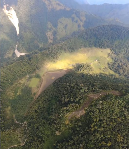
On February 18, a commission from the Colombian Geological Service (SGC) visited the La Florida farm, near the volcano, to inspect a possible change in soil temperature and certain changes in vegetation reported by inhabitants of the sector.
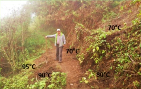
On February 18, 2023, officials from the Colombian Geological Service (SGC) traveled to Finca La Florida near the VCM to carry out an inspection due to reported changes in vegetation and possible increase in ground temperature. The area is located 300 meters above the La Florida thermal spring, with a temperature close to 79°C, a value measured on September 20, 2022, during the last geochemical sampling carried out by the SGC.
During the inspection, temperature data was taken with values between 70° and 95°C, a pulsating vapor outflow and dry and burnt looking vegetation were observed. No odor was detected. This type of manifestation of volcanic activity on the surface is typical of active volcanoes with changes in their behavior, that is, at a yellow level, as is the case with VCM.
The SGC will carry out more detailed sampling in the area to monitor these changes and establish their possible origin.
The other parameters used for the complete diagnosis of volcanic activity did not show significant changes during the period evaluated.
The COLOMBIAN GEOLOGICAL SERVICE remains attentive to the evolution of the volcanic phenomenon and will continue to report in a timely manner any changes that may occur.
Source : SGC.
Photos : SGC, Dheleony drone pilot.