
August 13 , 2022.
Back to business…
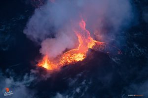
Iceland , Reykjanes Peninsula :
The fissure eruption of the Krýsuvík-Trölladyngja volcanic system that began at around 1318 on 3 August continued at least through 9 August. Numerous small lava fountains rose along the fissure, located near the border of the previous flow field N of Fagradalsfjall, and lava flows traveled downslope to the NW. Scientists from the Institute of Earth Sciences stated that the initial flow rate was 5-10 times greater than the flow rate at the start of the 2021 eruption, based on model estimates, field data, and satellite measurements. The flow rate was about 32 cubic meters per second during the initial hours of the eruption, then decreased to an average of 18 cubic meters per second from 17h00 on 3 August until 11h00 on 4 August, by which time about 1.6 million cubic meters of lava had covered an area of 0.14 square kilometers. The average flow thickness was around 11 m. According to a news article the length of the active fissure had decreased and the middle part of the fissure was the most active. On 5 August Icelandic Meteorological Office (IMO) reported that the number of daily earthquakes declined after the eruption began and deformation stabilized. Thousands of people were walking on the trails to view the eruption; authorities warned the public to heed inclement weather warnings, and closed access to the site during 7-9 August due to weather conditions and trail maintenance.
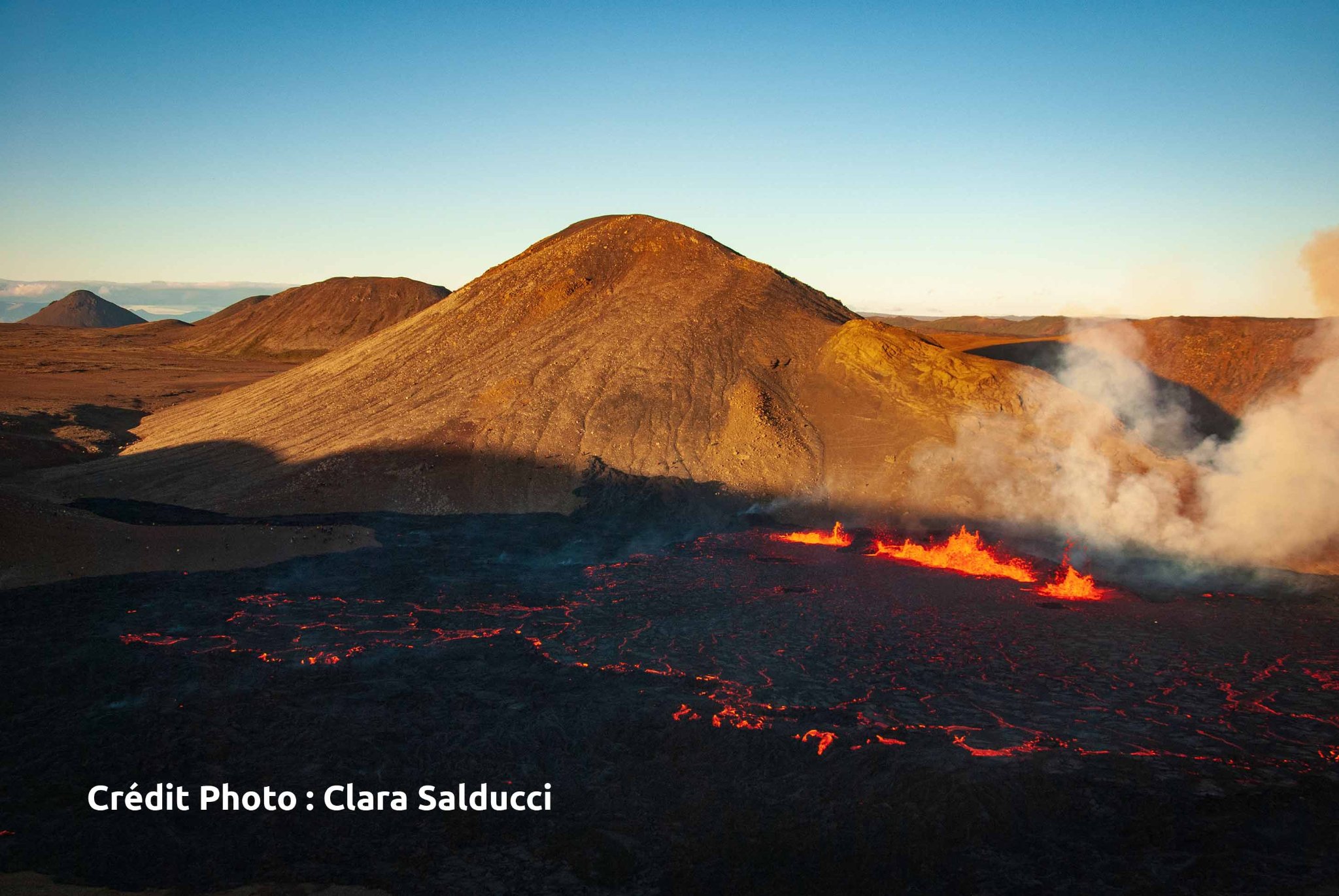
Update on the eruption in Fagradalsfjalli mountain in Meradalir valley on 12-August-2022
The amount of lava that is now erupting according to latest news is about 15m3/sec. This is higher than the eruption in Geldingadalir in 2021.
The lava seems to have filled up the valley the eruption started in. The floor seems to be about 10 to 30 meters high depending on location.
The crater has formed to some extend. The lava lake that remains there blocks the formation of a normal crater for now. This might change with time as the eruption continues.
Lava flow go both in south and north direction. The north lava flow goes into a smaller valley that was there. This is the long way out of the valley for now.
There is a risk that the lava flow is going to reach road 427 (Suðurstrandavegur) in few weeks time.
The risk of new eruption sites opening up remains high and that risk increases as the eruption goes on.
There is a swarm of small earthquakes that has been happening regularly since the start of the eruption in the dyke. It is unclear why that is happening.
It appears that a lava fountain has occurred in the past few hours. This has not yet been confirmed.
Source : GVP , IMO. Icelandgeology.net
Photo : Clara Salducci / 80 jours voyages
Philippines , Taal :
This is a notice of increased volcanic SO2 gas emission from Taal Volcano.
A total of 13,572 tonnes/day of volcanic sulfur dioxide or SO2 gas emission from the Taal Main Crater was recorded yesterday that produced significant volcanic smog or vog over Taal Caldera. Airborne volcanic gas is expected to be drifted to the general east to north-northeast of Taal Volcano Island or TVI based on air parcel trajectory data from PAGASA. SO2 flux since 15 July 2022 has averaged 7,818 tonnes/day, an increase from the average of 1,289 tonnes/day between May and mid-July 2022. Since the beginning of August 2022, there has been an increase in degassing activity in the form of visible upwelling of volcanic fluids in the Main Crater Lake and emission of voluminous steam-rich plumes that last night rose 2,800 meters above TVI. Vog over the Taal Caldera yesterday was observed to thicken between 9:00 AM to 2:00 PM, while sulfurous stench was reported by residents of Banyaga, Agoncillo; Poblacion 5, Boso-boso, and Gulod, Laurel; and Poblacion, Talisay, Batangas. Crop damage that likely resulted from acid rain was reported in Cabuyao, Laguna last 8 August 2022. A total of five shallow (5) volcanic tremor events 3 to 8 minutes in duration were recorded in the past observation period.

As a reminder, vog consists of fine droplets containing volcanic gas such as SO2 which is acidic and can cause irritation of the eyes, throat and respiratory tract with severities depending on the gas concentrations and durations of exposure.
DOST-PHIVOLCS reminds the public that Alert Level 1 prevails over Taal Volcano, which means that it is still in abnormal condition and should not be interpreted to have ceased unrest nor ceased the threat of eruptive activity. Should an uptrend or pronounced change in monitored parameters forewarn of renewed unrest, the Alert Level may be raised back to Alert Level 2.
DOST-PHIVOLCS is closely monitoring Taal Volcano’s activity and any new significant development will be immediately communicated to all stakeholders.
Source : Phivolcs
Photo : CCTV.
Hawaii , Mauna Loa :
Scientists at the USGS Hawaiian Volcano Observatory (HVO) were kept up the evening of August 2 and into the early hours of August 3 monitoring Mauna Loa. Over a period of about ten hours, 90 earthquakes were located beneath Mauna Loa’s summit region, and many more earthquakes were detected, but were too small to precisely locate. The total number of earthquakes peaked at over 200 per hour.
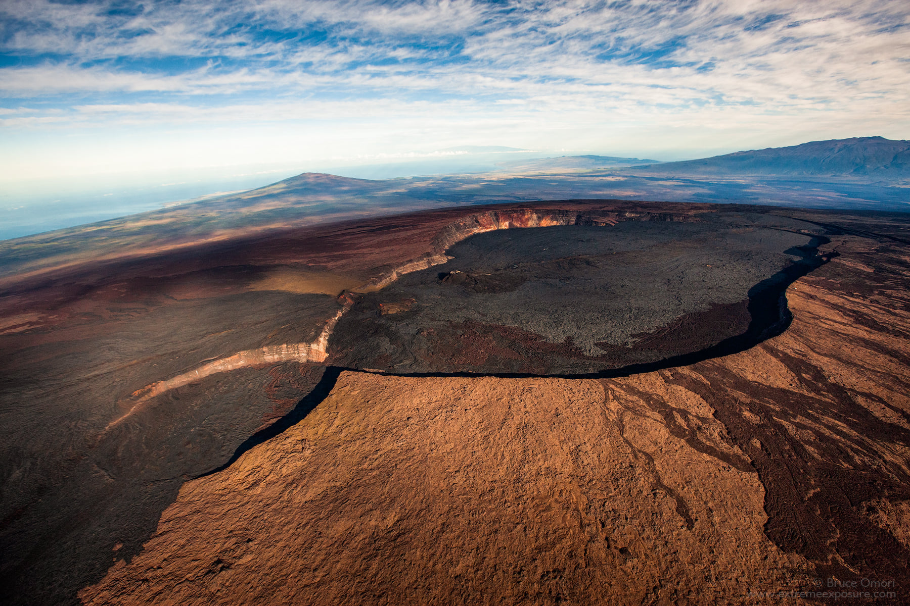
The earthquakes occurred around 2 miles (3 km) below the surface of Mauna Loa’s summit and their locations did not shift horizontally or vertically to another region or depth over time. The observation that the earthquakes did not get shallower was a comforting indicator that the swarm was unlikely to be from magma rapidly ascending into an eruption.
An earthquake swarm in-and-of-itself is not unique—swarms have happened beneath Mauna Loa’s summit in the past. During the Spring of 2021, an earthquake swarm beneath Mauna Loa’s summit produced about a thousand earthquakes over a span of seven weeks with a peak rate of 40 earthquakes per day.
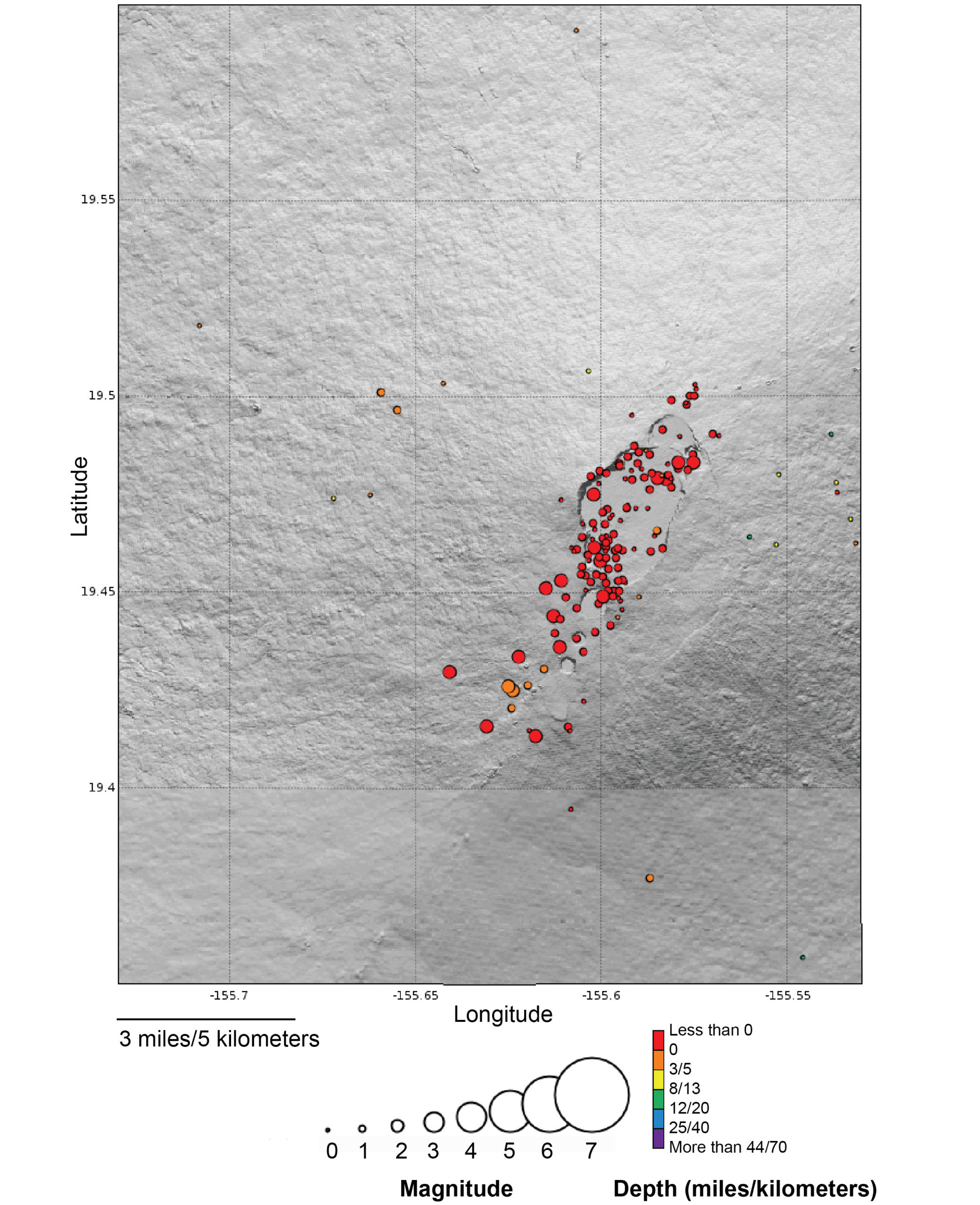
Map showing located earthquakes below Mauna Loa summit region between midnight August 1 and midnight August 3, 2022. Orange earthquakes are below sea level whereas red earthquakes are above sea level; earthquakes are sized by magnitude.
Another unique occurrence was the change in another monitoring dataset. As the earthquakes were occurring from August 2–3, a tiltmeter on the north side of Moku‘āweoweo—Mauna Loa’s summit caldeira—showed a change of about 1.5 microradians.
Mauna Loa earthquake activity and ground deformation have returned to previous levels following the August 2–3 event and an eruption is not imminent.
Source : HVO
Photos : Bruce Omori , HVO.
Colombia , Chiles / Cerro Negro :
Chiles and Cerro Negro volcanoes weekly activity bulletin
Volcano activity continues at YELLOW LEVEL ■ (III): CHANGES IN THE BEHAVIOR OF VOLCANIC ACTIVITY.
From monitoring the activity of the CHILES AND CERRO NEGRO VOLCANOES, the COLOMBIAN GEOLOGICAL SERVICE (SGC) reports that:
For the period assessed between August 2 and August 8, 2022, changes in the behavior of volcanic activity continue. These changes, which were accentuated with the process of the seismic swarm, events associated with the fracture of the solid material inside the volcanic system, which began on May 27, 2022, presented a decrease, both of the occurrence and the seismic energy released.
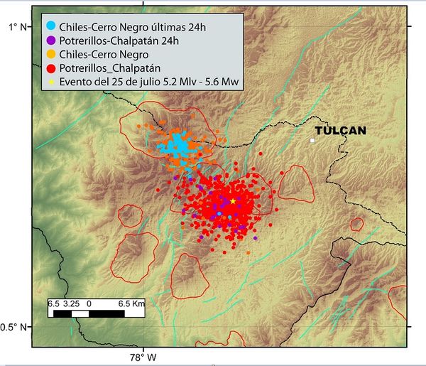
This represents during the evaluated period, a total of 8605 earthquakes, of which 8344 were associated with the fracturing of rocks, mainly located towards the southern sector of the zone of influence of the Chiles volcano, with a first source which is extends from the vicinity of the Chiles volcano to 4 km south of it, with depths not exceeding 6 km from its summit, and another source more distant to the southeast of the volcanic edifice of Chiles, swarm which resumed its activity on July 23, at epicentral distances between 5 and 15 km. , in a depth range of 6 to 14 km from the volcanic summit (4700 m. ). Events recorded on August 4 and 6 at 3:30 p.m. and 12:34 a.m. with a magnitude of 3.1 and 3.4 respectively are highlighted, which were reported as felt in the volcanic influence zone.

All these seismic manifestations are part of a process of ground deformation (observed instrumentally) which began at the end of March 2022 and continues to this day.
Based on the current behavior of this seismicity and what has been historically recorded in this active volcanic region, the possibility of the occurrence of more high-energy earthquakes, which can be felt by the inhabitants of the area of volcanic influence, is not excluded.
Source : SGC
Photo : buenaventuraenlinea.com.
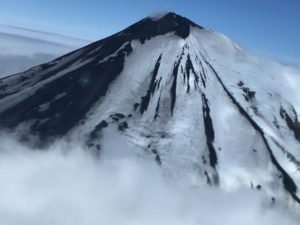
Ecuador , Sangay :
Information on the activity of the SANGAY VOLCANO, Quito, Friday, August 12, 2022, Updated 8:00 p.m. TL.
Today, there has been an increase in the internal and surface activity of the Sangay volcano. From 10:00 TL, an increase in seismic energy is recorded, which resulted in the emission of a new lava flow, with sounds heard in Guayaquil and ash falls in the province of Chimborazo and possibly in Guayas. Due to the good weather conditions, the sounds and the ash emission had higher than normal ranges.
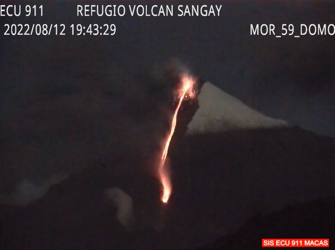
This pulse of activity is distinguished by the emission of a large lava flow which was observed with satellite images and the ECU-911 cameras. If this activity continues and the weather conditions are good, incandescence can be seen from the town of Macas and sounds can be heard during the night and early morning in towns far from the volcano. On the other hand, if heavy rains occur, the new material can be easily eroded and generate lahars towards the Volcán and Upano rivers. The lava flows more than 1 km on the southeast flank of the Sangay volcano.
Updated 6:30 p.m. TL. The ash cloud from the Sangay volcano extends to Guayaquil. This emission has already caused ash falls in the province of Chimborazo (Cebadas and Palmira). For the moment, the cloud is diffuse and could cause a slight ash fall in Guayaquil. Thanks to the good meteorological conditions, this low altitude emission managed to travel more than 200 km to the west of the volcano. This phenomenon has been recurrent during the current eruptive period which began in May 2019. IG-EPN continues to monitor the event and will report in a timely manner if any changes in monitoring signals are detected.
The Geophysical Institute is monitoring and any news will be reported.
Source : IGEPN
It’s good to have you back
merci , ça fait plaisir.