July 28 , 2022.
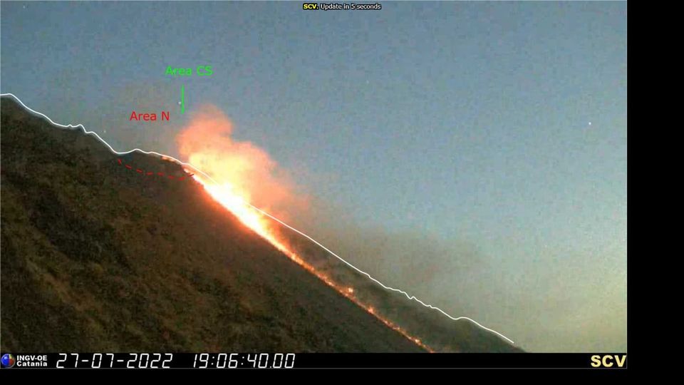
Italy , Stromboli :
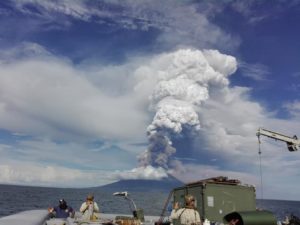
VOLCANIC ACTIVITY COMMUNICATION July 27 , 2022 , 17:30:49 (UTC) – STROMBOLI.
The National Institute of Geophysics and Volcanology, Osservatorio Etneo , announces that the monitoring networks recorded at 19:30 (17:30 UTC), starting from 17:30 UTC a lava overflow is observed from the North crater area , which stands in the upper part of the Sciara. From the seismic point of view, there was a slight increase in tremor at 17:04 UTC which returned to the previous values within about 30 minutes.
From the signals of the stations of the inclinometric and GNSS networks, no detectable ground deformations are deduced.
Source : INGV.
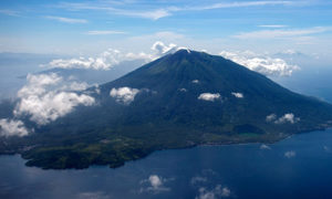
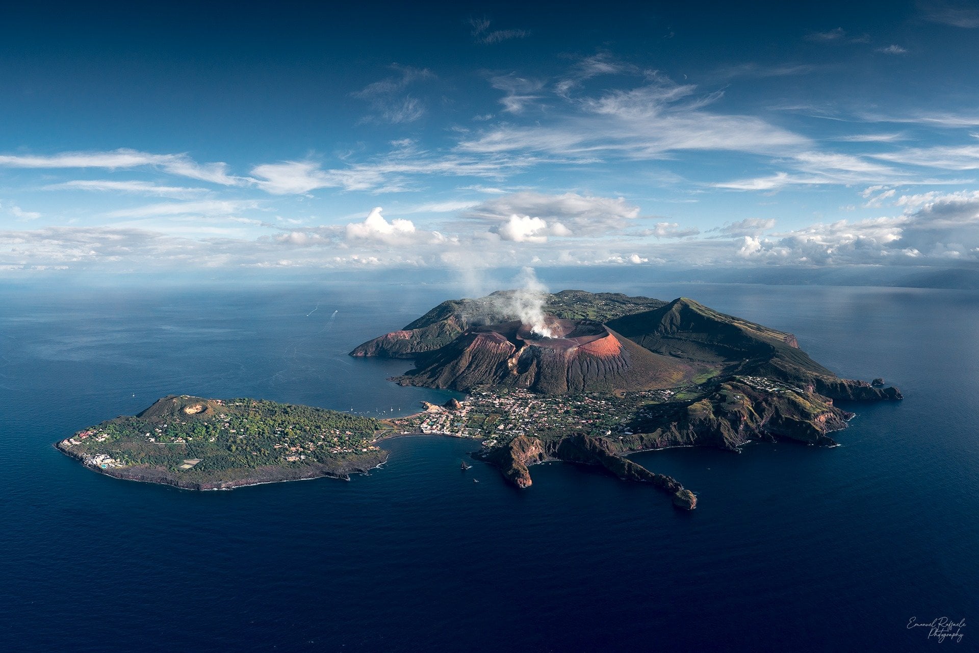
Italy , Vulcano :
WEEKLY BULLETIN, from July 18, 2022 to July 24, 2022. (issue date July 26, 2022)
ACTIVITY STATUS SUMMARY
In the light of the surveillance data, it is highlighted:
1) Temperature of the crater fumaroles: The temperatures recorded on the rim of the crater show very stable values with a weekly average of 376°C.
2) CO2 flux in the crater area: The CO2 flux in the crater area remains at medium-high values.
3) SO2 flux in the crater area: SO2 flux at a medium-high and stable level
4) Geochemistry of fumarolic gases: There are no updates. A sample will be taken in the next few days.
5) CO2 fluxes at the base of the La Fossa cone and in the Vulcano Porto area: Stable values of CO2 fluxes in the Rimessa and Camping Sicilia sites; on the Faraglione and P4max sites, values close to the background noise are recorded.
6) Geochemistry of thermal aquifers: The physico-chemical parameters recorded in the Camping Sicilia well show unreliable values due to problems with the probe, replacement operations are in progress. The level and conductivity values measured in the Bambara well do not show any significant variations.
7) Local seismicity: Low rate of occurrence of local micro-seismicity with a spectral peak greater than 1 Hz. Increase in the daily number of low frequency events (VLP).
8) Regional seismicity: No earthquake with Ml >= 1.0 was located in the Vulcano region last week.
9) Deformations – GNSS: No variation to report. Data from high-frequency elaborations are not currently available.
10) Deformations – Inclinometry: No variation to report in the inclination data
11) Gravimetry: Gravimetry: No significant medium-long term variation was recorded.
12) Other Notes: Mobile GNSS. The GNSS mobile network acquires and transmits movements in real time at a frequency of 1 Hz. The historical series acquired so far do not show significant variations around the Porto di Levante area.
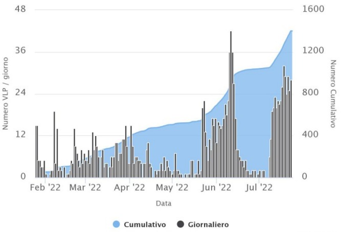
LOCAL SEISMICITY
In the week considered, the number of microshocks with a spectral peak greater than 1 Hz is globally low and comparable to that observed the previous week. As far as low-frequency type events (VLP; dominant peak below 1 Hz) are concerned, the increase in the daily number already reported last week has continued.
Source : INGV.
Photo : Emanuel Raffaele Photography.
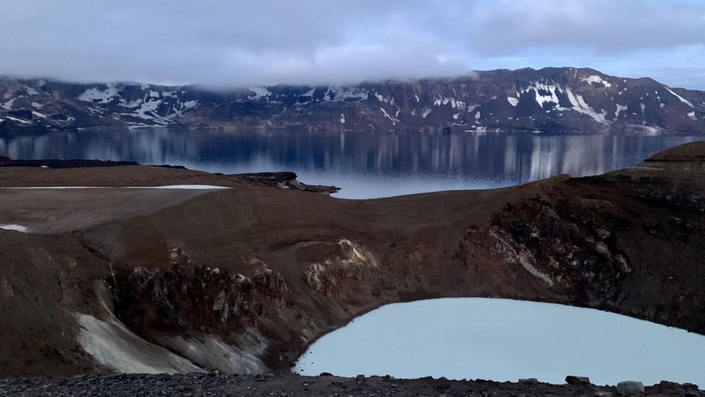
Iceland , Askja :
The Askja volcano has apparently awakened from its 60-year slumber. Volcanologists are now convinced of this. “What makes Askja special is the land subsidence of the last decades, which since the end of July last year has turned into the opposite. The land started to rise, and relatively quickly,” says geologist Magnús Tumi Guðmundsson.
If this process continues, it could end in a volcanic eruption. The uplift of the earth now measures 35 centimeters, its center is located west of Lake Öskjuvatn.
Little seismic activity so far Emergency services and volcanologists met last year and yesterday to discuss the situation. Since the snow has melted, the uplift is more clearly visible. The reason is believed to be an accumulation of magma, which is located about two kilometers below the earth’s crust. According to computer models, the magma is distributed horizontally in the earth’s crust, in the middle of the volcano.
It is remarkable in this context how low seismic activity is relative to land elevation. What is certain is that the Askja needs a long time before reacting and that there could be an earthquake swarm, explains Magnús Tumi.
“Because of the land subsidence of the past decades, you could compare it to the fact that the reservoir over there is half empty. First, something has to be done before the limit is reached. This is the most likely explanation. »
For the area around Askja, a fissure eruption is most likely. If the land opens under the lake, expect an explosive eruption, like the one that occurred in 1926. At that time, the small island formed in the middle of the lake.
Another scenario from the Volcanoes Department of the Meteorological Service shows continued uplift, which does not end in an eruption. An eruption, on the other hand, would be announced with seismic activity, even if the warning time of a few hours would be rather short.
Source : icelandreview.com /
Photo : Alma Ómarsdóttir – RÚV.
Japan , Sakurajima :
A notable eruption at Minamidake Crater (at Aira Caldera’s Sakurajima volcano) occurred on 24 July. The event was preceded by inflation first detected at around 09h00 on 18 July. JMA warned residents that the inflation represented an intrusion of magma that could result in a large explosion. Sulfur dioxide emissions were at 1,900 tons per day, measured during a field visit on 22 July. Four eruptive events recorded between 23 July and 15h00 on 24 July produced plumes that rose 1.2 km above the crater rim; the events did not change the rate of inflation. A larger eruptive event occurred at 20h05 on 24 July that ejected bombs more than 2.4 km E, the first time material fell beyond 2 km from the crater since 4 June 2020.

The event produced minor plumes that rose 300 m before mingling with weather clouds. The Alert Level was raised to 5 (the highest level on a 5-level scale) at 20h50, signaling that residents should evacuate. According to a news article 51 people in 33 households living within a 3-km radius of both Minamidake and Showa craters left their homes. Ashfall was reported in Kagoshima City (about 10 km W). JMA noted that inflation ceased after the event. On 25 July JMA scientists conducted a field visit and confirmed that bombs were deposited more than 2.4 km from the vent and observed ashfall in an area from Shirahamacho to Kurokamicho. During 25-26 July a few small explosions and eruptive events generated plumes that rose as high as 2.2 km above the crater rim and disappeared into the weather clouds. Deformation had stagnated.
Sources : GVP , JMA.
Photo : JMA.
Chile , Puyehue-Cordon Caulle :
Special Report on Volcanic Activity (REAV), Los Lagos region, Puyehue-Cordon Caulle volcanic complex, July 26, 2022, 10:33 p.m. local time (mainland Chile).
The National Service of Geology and Mines of Chile (Sernageomin) publishes the following PRELIMINARY information, obtained through the monitoring equipment of the National Volcanic Monitoring Network (RNVV), processed and analyzed at the Volcanological Observatory of the Southern Andes ( Ovdas):
On Tuesday July 26, 2022, at 10:16 p.m. local time (Wednesday July 27 02:16 UTC), the monitoring stations installed near the Puyehue-Cordon Caulle volcanic complex recorded an earthquake associated with rock fracturing (volcano-tectonic type) in the volcanic system.
The characteristics of earthquakes after their analysis are as follows:
ORIGINAL TIME: 22:16 local time (Wednesday July 27 02:16 UTC)
LATITUDE: 40.514°S
LONGITUDE: 72.127°W
DEPTH: 4.1km
LOCAL MAGNITUDE: 3.0 Ml
COMMENTS:
Following the occurrence of the volcano-tectonic event, events of similar characteristics of lower energy were recorded. No superficial activity was observed following this event.
The volcanic technical alert remains at the Green level.
Sources : Sernageomin.
Photo : wikiloc.
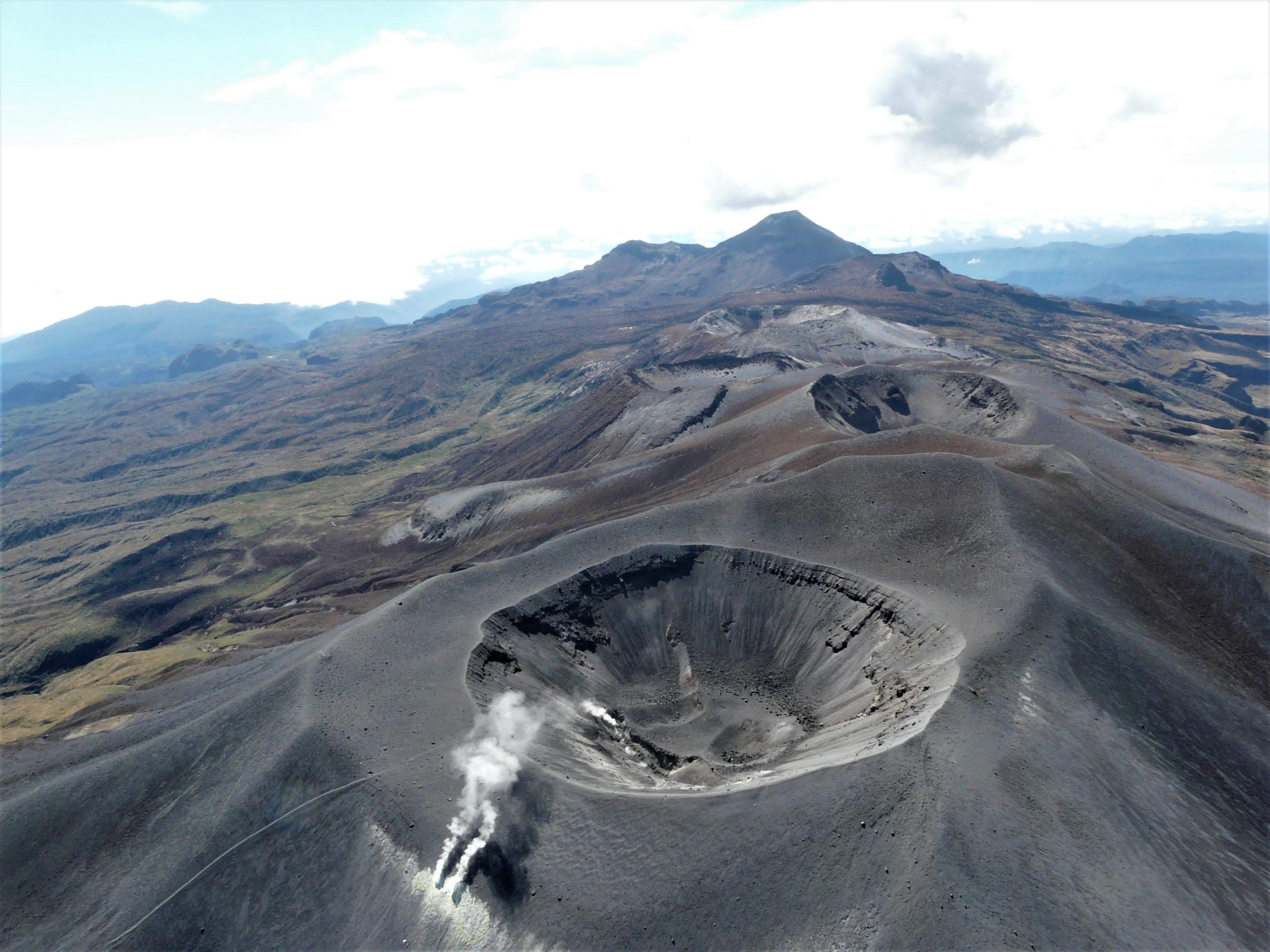
Colombia , Purace – Los Coconucos Volcanic Range :
Weekly bulletin of the activity of the Puracé volcano – Los Coconucos volcanic chain.
The level of activity of the volcano continues at the Yellow activity level or (III): changes in the behavior of volcanic activity.
From the analysis and evaluation of the information obtained through the monitoring network of the Puracé volcano – Los Coconucos volcanic chain, during the week of July 19 to 25, 2022, the COLOMBIAN GEOLOGICAL SERVICE – Volcanological and Seismological Observatory of Popayan reports that:
During this week, the strong occurrence of earthquakes associated with the movement of fluids inside the volcano continues. A total of 565 seismic events were presented, of which 55 were associated with rock fracturing processes (type VT) and 510 with fluid dynamics in volcanic conduits; of these, 454 were classified as long duration events (type LP), 5 (five) were associated with both failure mechanisms and fluid dynamics and were classified as hybrid (type HB), 11 were classified as low frequency events. (type BF), 5 in the form of « tornillo » type earthquakes (type TO) and 35 in the form of low energy tremor pulses (type TR).
The geodetic network of GNSS (Global Navigation Satellite System) stations for monitoring ground deformation continues to record a process associated with inflation.
In the monitoring of surface activity, the images obtained during the week thanks to the Anambío, Mina, Lavas Rojas and Cerro Sombrero web cameras showed degassing of the volcanic system, with a white column oriented preferentially towards the North-West. .
Sensors that measure spontaneous electrical potential recorded a remarkable change on July 13, the value of which did not return to the average level observed since the last
months of monitoring.
Magnetic field and infrasonic wave monitoring sensors did not record variations associated with changes in volcanic activity.
It is concluded from the above that significant variations in volcanic activity continue to be recorded, consistent with the behaviors expected at activity level III (yellow level), which could evolve towards states of greater activity.
Source et photo: SGC
Guatemala , Santiaguito :
LAHAR IN THE CABELLO DE ÁNGEL RIVER, TRIBUTARY TO THE SAMALÁ RIVER
Heavy rainfall on the Santa María-Santiaguito volcanic complex is currently generating the descent of lahars into the Cabello de Ángel river, a tributary of the Nimá I and Samalá rivers, to the south-southwest of the volcano.
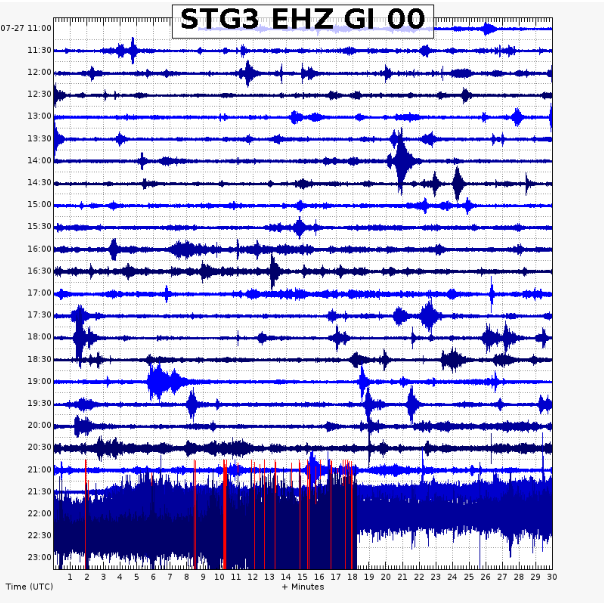
This lahar is weak in character, carrying a pasty mixture of water, boulders up to 1 meter in diameter, and finer sediments, as well as tree trunks and branches. The lahar on its way produces vibrations in the ground which are recorded in the seismic stations close to the bed of the river, in this case the STG3. The lahar may increase its intensity from weak to moderate in the next few minutes and, if these rainy conditions persist in the region, the possibility of lahars descending in one of the channels that emerge from the volcanic complex is not excluded.
Source : Insivumeh.