July 27 , 2022.
Italy / Sicily , Etna :
WEEKLY BULLETIN, from July 18, 2022 to July 24, 2022. (issue date July 26, 2022)
ACTIVITY STATUS SUMMARY
In the light of the surveillance data, it is highlighted:
1) VOLCANOLOGICAL OBSERVATIONS: Degassing activity of the summit craters
2) SEISMOLOGY: very low seismic fracturing activity; average amplitude of volcanic tremor at an average level.
3) INFRASOUND: Moderate infrasound activity with sources concentrated in the Bocca Nuova crater area.
4) GROUND DEFORMATIONS: There are no significant variations in the signals from the ground deformation monitoring networks. The inflation phase already announced in the previous weeks is continuing.
5) GEOCHEMISTRY: SO2 flux at an average level
Soil CO2 flux shows average values.
The partial pressure of dissolved CO2 in groundwater shows values in seasonal variability.
Helium data from the latest sample shows no significant changes from previous ones, settling on the high level.
6) SATELLITE OBSERVATIONS: The thermal activity observed by satellite in the summit area was weak.
VOLCANOLOGICAL OBSERVATIONS
During the week in question, the monitoring of Etna’s volcanic activity was carried out through the analysis of images from the network of surveillance cameras of the INGV, Osservatorio Etneo (INGV-OE) and through an inspection in the summit area carried out by INGV-OE staff on July 20.
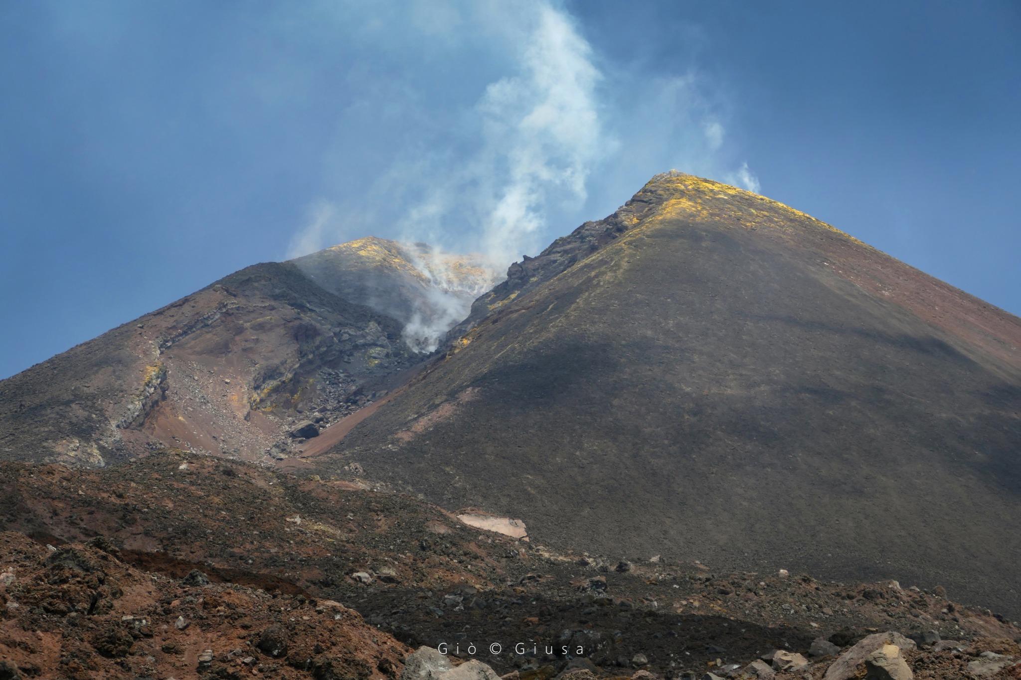
Overall, the state of activity of the summit craters did not indicate any specific significant changes compared to what was observed during the last weeks and in the phases following the effusive activity of May / June 2022 . The activity is dominated by a degassing regime mainly localized at Bocca Nuova, intense and sometimes impulsive and characterized by flashes visible at night. Regarding the Southeast Crater in this period, it showed moderate degassing of the fumarolic field present along the edges of the crater. Finally, the Northeast Crater is affected by weak gas emissions from certain fumaroles present on the internal walls of the crater, while the Voragine Crater still persists with an absence of degassing.
SEISMOLOGY
During the week in question, the seismic activity related to the fracturing events was very weak and no event reached or exceeded the local magnitude value of M2.0.
Source : INGV.
Photo : Gio Giusa.
Russia / Kuril Islands , Ebeko :
VOLCANO OBSERVATORY NOTICE FOR AVIATION (VONA)
Issued: July 27 , 2022
Volcano: Ebeko (CAVW #290380)
Current aviation colour code: ORANGE
Previous aviation colour code: orange
Source: KVERT
Notice Number: 2022-83
Volcano Location: N 50 deg 41 min E 156 deg 0 min
Area: Northern Kuriles, Russia
Summit Elevation: 1156 m (3791.68 ft)
Volcanic Activity Summary:
A moderate eruptive activity of the volcano continues. According to visual data by volcanologists from Severo-Kurilsk, an explosion sent ash up to 2.5 km a.s.l., an ash cloud is drifting to the north of the volcano.
A moderate eruptive activity of the volcano continues. Ash explosions up to 6 km (19,700 ft) a.s.l. could occur at any time. Ongoing activity could affect low-flying aircraft and airport of Severo-Kurilsk.
Volcanic cloud height:
2500 m (8200 ft) AMSL Time and method of ash plume/cloud height determination: 20220727/0156Z – Visual data
Other volcanic cloud information:
Distance of ash plume/cloud of the volcano: 10 km (6 mi)
Direction of drift of ash plume/cloud of the volcano: N
Time and method of ash plume/cloud determination: 20220727/0156Z – Visual data
Source : Kvert.
Photo : L. Kotenko. IVS FEB RAS.
Italy , Stromboli :
WEEKLY BULLETIN, from July 18, 2022 to July 24, 2022. (issue date July 26, 2022)
ACTIVITY STATUS SUMMARY
In the light of the surveillance data, it is highlighted:
1) VOLCANOLOGICAL OBSERVATIONS: Explosive volcanic activity of the Strombolian type with a total frequency at a moderately medium-low level and increasing, and with an intensity of explosions at a low to medium level in the areas of the North and Center-South craters.
2) SEISMOLOGY: The seismological parameters monitored do not show any significant variations.
3) GROUND DEFORMATIONS: Only the modest impulsive variation linked to the explosion of 7/25 at 2:55 a.m. is noted, clearly visible in the N275E component of the TDF inclination
4) GEOCHEMISTRY: SO2 flux at a low level
The soil CO2 flux in the summit area shows average values.
The average weekly value of the C/S ratio in the plume is on average values.
5) SATELLITE OBSERVATIONS: The thermal activity observed by satellite in the summit area was weak.
VOLCANOLOGICAL OBSERVATIONS
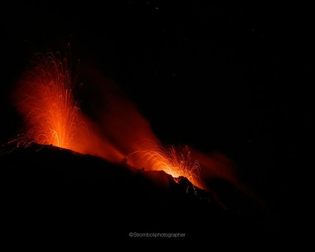
During the observation period, the eruptive activity of Stromboli was characterized thanks to the analysis of the images recorded by the network of INGV-OE surveillance cameras on the visible and the thermal (altitude 190m, Punta Corvi, altitude 400m and Pizzo). The explosive activity was produced by 4 eruptive vents located in the North crater area and 2 eruptive vents located in the Center-South crater area; all the mouths are located inside the depression which occupies the terrace of the crater.
With regard to the area of the CS crater, the explosive activity was located at the S2 crater with explosive events dominated by mainly fine materials (ash) and secondarily by coarse materials; S1 was instead characterized by mild degassing activity at a variable rate with no eruptive activity. The frequency of explosions remained at a low level with the persistence of the increase recorded since the beginning of July. The intensity of the explosions ranged from low level to moderately medium.
In the area of the North crater, the activity was localized to the N1 crater with explosions emitting mainly fine materials (ash) mixed with coarse materials, while the N2 showed continuous degassing. During the week, the sustained outgassing/puffing activity produced by a vent placed on the outer side of N2 continued. Overall, the frequency of explosions remained at a low level with an intensity ranging from low (less than 80 m high) to medium (less than 150 m high).
Finally, with regard to the frequency of total explosions, the eruptive activity is at a moderately medium-low level and has been increasing since the beginning of July, with a slight prevalence
of the CS zone compared to that N
Source : INGV.
Photo : Stromboli stati d’animo / stromboliphotographer.
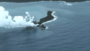
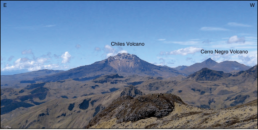
Colombia , Chiles / Cerro Negro :
San Juan de Pasto, 26 juillet 2022, 15h40 . Bulletin d’activité hebdomadaire des volcans Chiles et Cerro Negro.
L’activité des volcans se poursuit au NIVEAU JAUNE ■ (III) : CHANGEMENTS DANS LE COMPORTEMENT DE L’ACTIVITÉ VOLCANIQUE.
D’après le suivi de l’activité des VOLCANS CHILES ET CERRO NEGRO, le SERVICE GÉOLOGIQUE COLOMBIEN (SGC) rapporte que :
Pour la période évaluée entre le 19 et le 25 juillet 2022, les changements dans le comportement de l’activité volcanique se sont poursuivis. Ces changements, qui ont été accentués par le processus de l’essaim sismique d’événements associés à la fracture de la roche à l’intérieur du système volcanique, qui a commencé le 27 mai 2022, ont montré une augmentation notable, à la fois en occurrence et en énergie libérée.
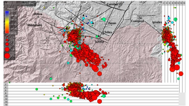
Carte des emplacements des événements sismiques entre le 27 mai et le 26 juillet 2022. L’échelle de couleurs est conforme à l’enregistrement temporel des tremblements de terre et la taille des cercles fait référence à la magnitude, la valeur maximale étant de 5,6 Mw pour le tremblement de terre du 25 juillet 2022. Les failles, les alignements structurels et les principales villes sont incluses pour référence
Sur la période évaluée un total de 21 815 événements, dont 21 362 associés à la fracturation des roches ont été enregistrés, mettant en évidence la survenue d’un séisme de magnitude 5,7 le 25 juillet à 8h33, soit le plus grand événement enregistré depuis le début de la surveillance continue à partir de novembre 2013 . Ce tremblement de terre a été localisé à 15 km au Sud-Est du volcan Chiles, à une profondeur de 8 km de son sommet (4700 m d’altitude) et a été ressenti à certains endroits dans les départements de Nariño, Putumayo, Caquetá et Cauca, ainsi qu’à des endroits dans la province de Carchi en Équateur, causant quelques dégâts aux bâtiments, en particulier sur le territoire équatorien. Il y a également eu des dégâts dans les municipalités de Cumbal et Túquerres (département de Nariño).
Au cours de la semaine évaluée, 22 autres tremblements de terre de fracturation ont présenté des magnitudes supérieures ou égales à 2,5, qui, en raison de leur nature superficielle, ont été ressenties principalement dans la municipalité de Cumbal, (Département de Nariño) soulignant en outre ceux enregistrés le 22 juillet à 8h16. de magnitude 3,5 et à 5h46 avec une magnitude de 3,2 ; le 25 juillet à 8h38 de magnitude 3,9, à 9h41 avec 3.4 et à 9h57 avec une magnitude de 3,2 ; et aujourd’hui, 26 juillet, à 5 h 24. avec une magnitude de 4,1. Concernant leur localisation, la plupart de ces tremblements de terre ont été localisés dans trois sources principales : Une source plus proximale, récurrente tout au long de la période évaluée, qui s’étend de la proximité du volcan Chiles à 4km au Sud de celui-ci avec des profondeurs ne dépassant pas 6 km de son sommet; une autre source plus distale au Sud-Est de l’édifice volcanique du Chiles, qui a repris son activité le 23 juillet, à des distances épicentrales comprises entre 5 et 15 km, dans une plage de profondeur de 6 à 14 km par rapport au sommet volcanique, se démarquant le séisme de magnitude 5,7 . Enfin une autre source située au Sud et au Sud-Sud-Est du volcan Chiles, qui a commencé à enregistrer des événements le 25 juillet, à des distances d’épicentre comprises entre 6 et 12 km, avec des profondeurs comprises entre 7 et 12 km du sommet. De plus, au cours de la période évaluée, le nombre de tremblements de terre associés au mouvement des fluides à l’intérieur du système volcanique a augmenté, avec un total de 388, se démarquant le 25 juillet avec la survenue de 82 tremblements de terre de fluides, soit l’enregistrement quotidien le plus élevé depuis le début. du contrôle permanent en novembre 2013.

Toutes ces manifestations sismiques s’inscrivent dans un processus de déformation du sol (observé instrumentalement) qui a débuté fin mars 2022 et se poursuit à ce jour.
Sur la base du comportement actuel de cette sismicité et de ce qui a été historiquement enregistré dans cette région volcanique active, la possibilité de la survenue de plus de tremblements de terre à haut niveau d’énergie, pouvant être ressentis par les habitants de la zone d’influence volcanique, n’est pas exclue.
Source : SGC.
Photos : IGEPN , Researchgate.net , buenaventuraenlinea.com .
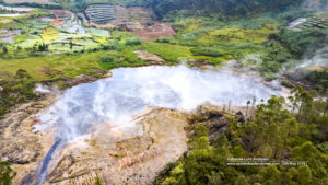
Iceland , Reykjanes Peninsula :
The SIL network detected around 800 earthquakes in and around Iceland in week 29 and have about 660 earthquakes been manually refined. This is a slight increase in seismicity compared to last week when about 600 earthquakes were detected.
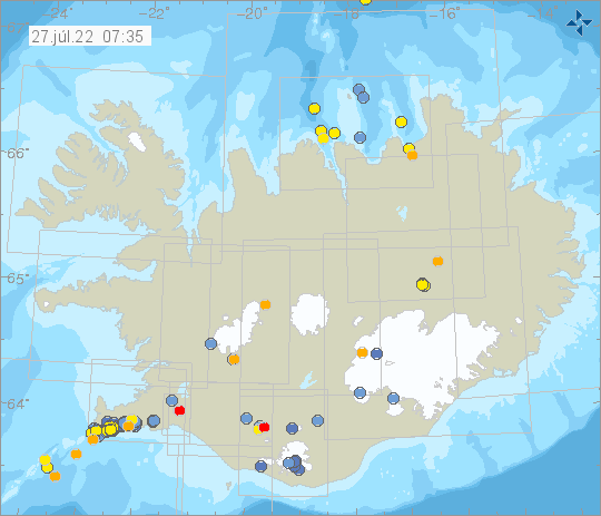
The biggest earthqaukes of the week occured in Bárðarbunga on 24th of July when two earthquakes over M4 was detected, they were M4.9 and M4.4. The seismic activity was spread over Reykjanes, east of Grímsey and in Mýrdalsjökull where about 20 earthquakes were detected, the largest was a M2.8.
Source et photo : Vedur is