July 12 , 2022.
Chile , Planchon- Peteroa :
Seismology
The seismological activity of the period was characterized by the recording of:
28 VT-type seismic events associated with rock fracturing (Volcano-Tectonics). The most energetic earthquake presented a value of local magnitude (ML) equal to 1.6, located 1.5 km west-northwest of the volcanic edifice, at a depth of 4.8 km from the active crater.
4 LP-type seismic events, associated with fluid dynamics within the volcanic system (Long Period). The size of the largest earthquake estimated from the reduced displacement parameter (RD) was equal to 1 cm2. No event presented the minimum energy to locate.
Fluid Geochemistry
No anomalies were reported in sulfur dioxide (SO2) emissions into the atmosphere in the area near the volcanic complex, according to data published by the Tropospheric Monitoring Instrument and Ozone Monitoring Instrument (OMI) Sulfur Dioxide Group.
Satellite thermal anomalies
During the period, no thermal alert was recorded in the area associated with the volcanic complex, according to the data processed by the Mid-Infrared Observation of Volcanic Activity (MIROVA) and by the analysis processing of the volcanic activity. Sentinel 2-L2A satellite images, in combination of false color bands.

Geodesy
From the data provided by 2 GNSS stations, which measure the deformation in the complex, displacements of very low amplitude can be observed, linked to seasonal variations. It is concluded that there is no evidence of relevant misrepresentation.
Surveillance cameras
The images provided by the fixed camera installed near the complex do not record any degassing columns or variations linked to surface activity.
Activity remained at levels considered low, suggesting stability of the volcanic system. The volcanic technical alert is maintained at:
GREEN TECHNICAL ALERT: Active volcano with stable behavior – There is no immediate risk.
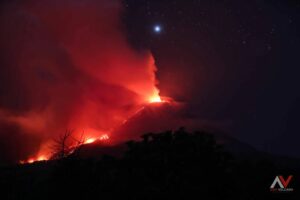
Special Report on Volcanic Activity (REAV), Region del Maule, Planchon-Peteroa Volcanic Complex, July 11, 2022, 01:50 local time (mainland Chile)
The National Geology and Mining Service of Chile (Sernageomin) publishes the following PRELIMINARY information, obtained through the monitoring equipment of the National Volcanic Monitoring Network (RNVV), processed and analyzed in the Volcanological Observatory of the Southern Andes (Ovdas) :
On July 11, 2022, at 01:23 a.m. local time (05:23 UTC), the monitoring stations installed near the Planchon-Peteroa volcanic complex recorded an earthquake associated with rock fracturing (volcano-tectonic type).
The characteristics of the earthquake after its analysis are as follows:
ORIGINAL TIME: 01:23 local time (05:23 UTC)
LATITUDE: 35.272°S
LONGITUDE: 70.462°W
DEPTH: 17.1 km
LOCAL MAGNITUDE: 3.6 (ML).
COMMENTS:
Subsequent to this report, no other event associated with the internal dynamics of the volcanic complex has been noted.
The volcanic technical alert remains at the GREEN level.
Source : Sernageomin
Photos : Sernageomin , REAL THINGTV CH2 ( 02 / 2019)
Peru , Sabancaya :
Analysis period: from July 04, 2022 to July 10, 2022, Arequipa, July 11, 2022.
Alert level: ORANGE
The Geophysical Institute of Peru (IGP) reports that the eruptive activity of the Sabancaya volcano remains at moderate levels, that is to say with the recording of an average of 20 daily explosions, with columns of ash and of gas up to 2.2 km altitude above the summit of the volcano and their subsequent dispersion. Therefore, for the following days, no significant change is expected in eruptive activity.
The IGP recorded and analyzed the occurrence of 297 earthquakes of volcanic origin, associated with the circulation of magmatic fluids inside the Sabancaya volcano. An average of 20 explosions was recorded daily, in addition to recording Volcano-Tectonic (VT) type events associated with rock fracturing inside the Sabancaya volcano.
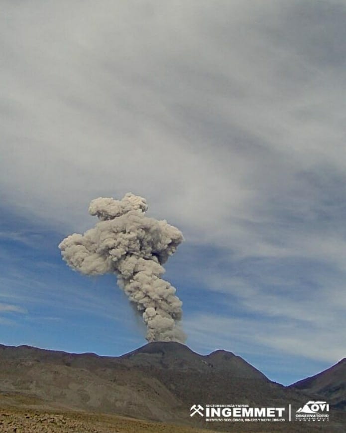
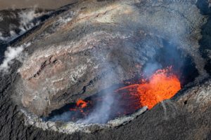
Monitoring the deformation of the volcanic structure using GNSS techniques (processed with fast orbits) does not show any significant anomalies. However, in general, an inflation process has been observed in the northern sector (surroundings of the Hualca Hualca volcano). Visual surveillance identified columns of gas and ash up to 2.2 km above the summit of the volcano, which were scattered towards the southeast, east and south sectors of Sabancaya. Satellite recordings have identified the presence of 6 thermal anomalies, with a maximum value of 8 MW, associated with the presence of a lava body on the surface of the volcano’s crater.
RECOMMENDATIONS
• Keep the volcanic alert level orange.
• Do not approach within a radius of less than 12 km from the crater.
Source : Cenvul
Photo : Ingemmet
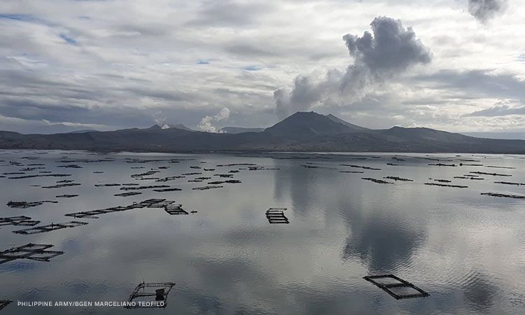
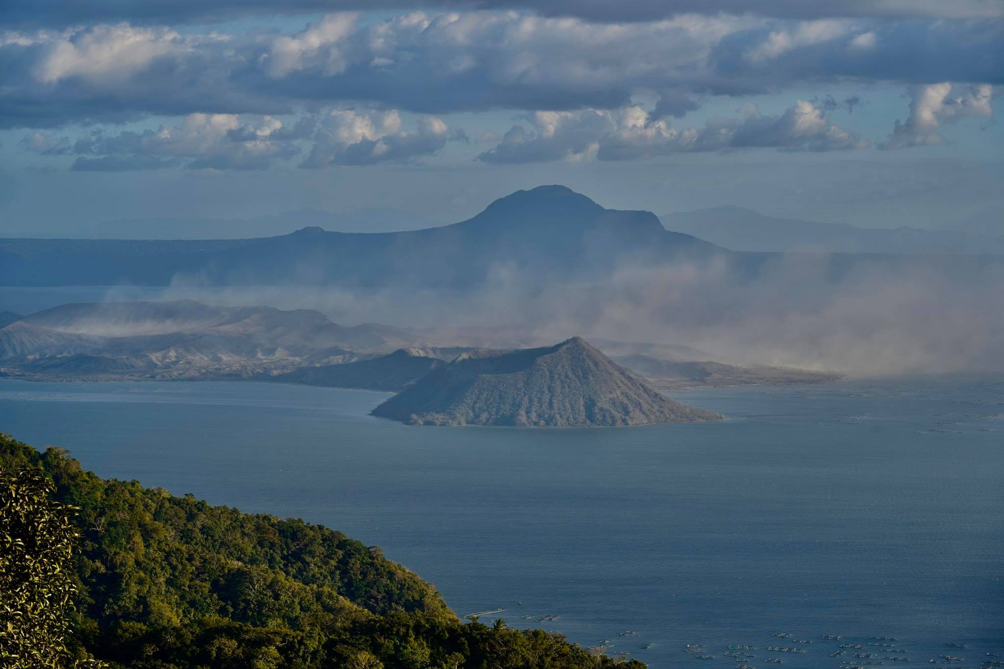
Philippines , Taal :
TAAL VOLCANO BULLETIN , 11 July 2022 , 8:00 AM
This serves as a notice for the lowering of Taal Volcano’s status from Alert Level 2 (Decreased Unrest) to Alert Level 1 (Low-Level Unrest).
Taal Volcano’s condition in the past two months has been characterized by baseline volcanic earthquake activity, stabilizing ground deformation of the Taal Caldera and Taal Volcano Island (TVI) edifices and weak degassing and surface activity at the Main Crater. These observations are supported by the following monitoring parameters:
1. Volcanic Earthquakes: The Taal Volcano Network (TVN) recorded a decline in the daily average of volcanic earthquakes from seven (7) events/day between 1 January and 31 May 2022 to zero (0) events/day since 13 June 2022. The sustained seismic quiescence for the past month indicates that degassing and rock-fracturing processes related to magmatic activity beneath TVI have abated, and that the possibilities of magma intrusion into the Main Crater have significantly decreased.
2. Ground Deformation: Continuous Global Positioning System (GPS) monitoring from November 2021 to April 2022 and Interferometric Synthetic Aperture Radar (InSAR) monitoring from January 2021 to June 2022 using ESA Sentinel-1 data recorded short- to medium-term deflation of Taal, with TVI deflation rates particularly declining (or slowing down), and slight uplift of western Taal Caldera. Such motions have been consistent with the overall ground deformation behavior of Taal Volcano since January 2020 and broadly with post-eruptive deflation of the Taal edifice.
3. Volcanic Gas Emission: Sulfur dioxide or SO2 flux based on campaign Flyspec data averaged 1,214 tonnes/day between May and July 2022, with the latest emission rates falling to 237 tonnes/day. Such low concentrations are consistent with weakened degassing from magma beneath TVI and volcanic gas being efficiently absorbed by the Main Crater Lake and by Taal’s recovered hydrothermal system.
4. Main Crater Observations: Surface activity has declined to weak emission of 300- to 2,400-meter tall steam-rich plumes from fumaroles or active gas vents on the Main Crater. The last significant activities from the Main Crater were phreatomagmatic bursts on 2 and 10 February and 26 March 2022 that respectively spewed 300- and 3,000-meter tall steam-rich plumes. Since then, background hydrothermal activity in the Main Crater Lake has been quietly transpiring.
In view of the above, DOST-PHIVOLCS is lowering the alert status of Taal Volcano from Alert Level 2 to Alert Level 1 to reflect the overall decrease in the level of monitoring parameters. Alert Level 1 means that the volcano is still in abnormal condition and should not be interpreted that unrest has ceased or that the threat of an eruption has disappeared. Should an uptrend or pronounced change in monitored parameters forewarn of renewed unrest, the Alert Level may be raised back to Alert Level 2. Residents of areas at high risk to base surges who have returned after the step-down to Alert Level 2 on 23 July 2021 must therefore remain vigilant and always prepared for a quick and organized evacuation. Conversely, should there be a return of monitoring parameters to baseline levels after a sufficient observation period, the Alert Level will be further lowered to Alert Level 0.
DOST-PHIVOLCS reminds the public that at Alert Level 1, sudden steam-driven or phreatic explosions, volcanic earthquakes, minor ashfall and lethal accumulations or expulsions of volcanic gas can occur and threaten areas within TVI. DOST-PHIVOLCS strongly recommends that entry into TVI, Taal’s Permanent Danger Zone or PDZ, especially the vicinities of the Main Crater and the Daang Kastila fissure, must remain strictly prohibited. Local government units are advised to continuously assess previously evacuated barangays around Taal Lake for damages and road accessibilities and to strengthen preparedness, contingency and communication measures in case of renewed unrest. People are also advised to observe precautions due to ground displacement across fissures, possible ashfall and minor earthquakes. Civil aviation authorities must advise pilots to avoid flying close to the volcano as airborne ash and ballistic fragments from sudden explosions and wind-remobilized ash may pose hazards to aircrafts.
DOST-PHIVOLCS is closely monitoring Taal Volcano’s activity and any new significant development will be immediately communicated to all stakeholders.
Source : Phivolcs
Photos : CNNPH , Marcello Teofilo , Raffy Tima
Hawaii , Mauna Loa :
19°28’30 » N 155°36’29 » W,
Summit Elevation 13681 ft (4170 m)
Current Volcano Alert Level: ADVISORY
Current Aviation Color Code: YELLOW
Activity Summary:
Mauna Loa Volcano is not erupting. Rates of seismicity remain slightly elevated above long-term background levels, but have not changed significantly over the past week. Other Mauna Loa monitoring data streams—ground deformation, gas concentrations, visual appearance in webcams—show no significant changes of late.
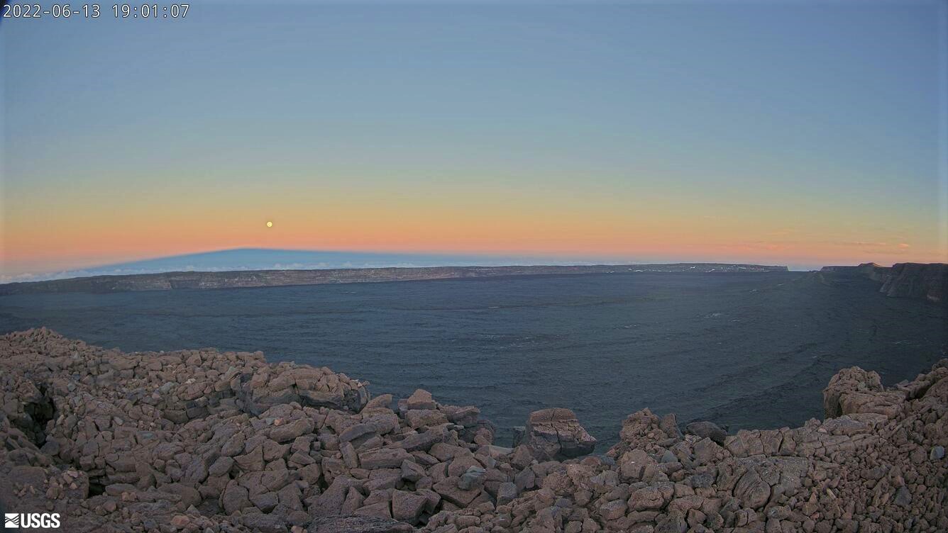
In the pastel colors of sunset, Mauna Loa’s shield-shaped shadow is illuminated in this image taken at approximately 7 p.m. HST on June 13, 2022, by the MLcam. The MLcam is located on the northwest rim of Moku‘āweoweo, the summit caldera.
Observations:
During the past week, HVO seismometers recorded 76 small-magnitude (below M3.0) earthquakes beneath the summit and upper-elevation flanks of Mauna Loa. The majority of these earthquakes occurred at shallow depths less than 15 kilometers (9 miles) below sea level.
Global Positioning System (GPS) measurements show steady rates of deformation in the volcano’s summit region continuing through the past week.
Concentrations of sulfur dioxide (SO2), hydrogen sulfide (H2S), and carbon dioxide (CO2), as well as fumarole temperatures, remain stable at both the summit and at Sulphur Cone on the upper Southwest Rift Zone.
Webcam views have shown no changes to the volcanic landscape on Mauna Loa over the past week.
Source et photo : HVO.
Kamchatka , Sheveluch :
VOLCANO OBSERVATORY NOTICE FOR AVIATION (VONA)
Issued: July 12 , 2022
Volcano: Sheveluch (CAVW #300270)
Current aviation colour code: ORANGE
Previous aviation colour code: orange
Source: KVERT
Notice Number: 2022-67
Volcano Location: N 56 deg 38 min E 161 deg 18 min
Area: Kamchatka, Russia
Summit Elevation: 3283 m (10768.24 ft), the dome elevation ~2500 m (8200 ft)

Volcanic Activity Summary:
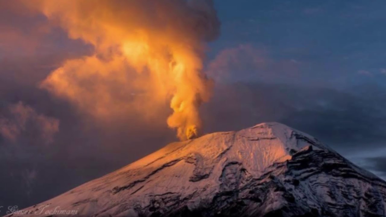
A growth of the lava dome continues, a strong fumarolic activity, and an incandescence of the lava dome, explosions, and hot avalanches accompanies this process. Video and satellite data by KVERT showed an ash plume up to 4.5 km a.s.l. extending to the south from the volcano.
The extrusive eruption of the volcano continues. Ash explosions up to 10-15 km (32,800-49,200 ft) a.s.l. could occur at any time. Ongoing activity could affect international and low-flying aircraft.
Volcanic cloud height:
4000-4500 m (13120-14760 ft) AMSL Time and method of ash plume/cloud height determination: 20220711/2330Z – Video data
Other volcanic cloud information:
Distance of ash plume/cloud of the volcano: 12 km (7 mi)
Direction of drift of ash plume/cloud of the volcano: S
Time and method of ash plume/cloud determination: 20220711/2330Z – Himawari-8
Source : Kvert
Photo : Yu. Demyanchuk, IVS FEB RAS, KVERT