May 04 , 2021 .
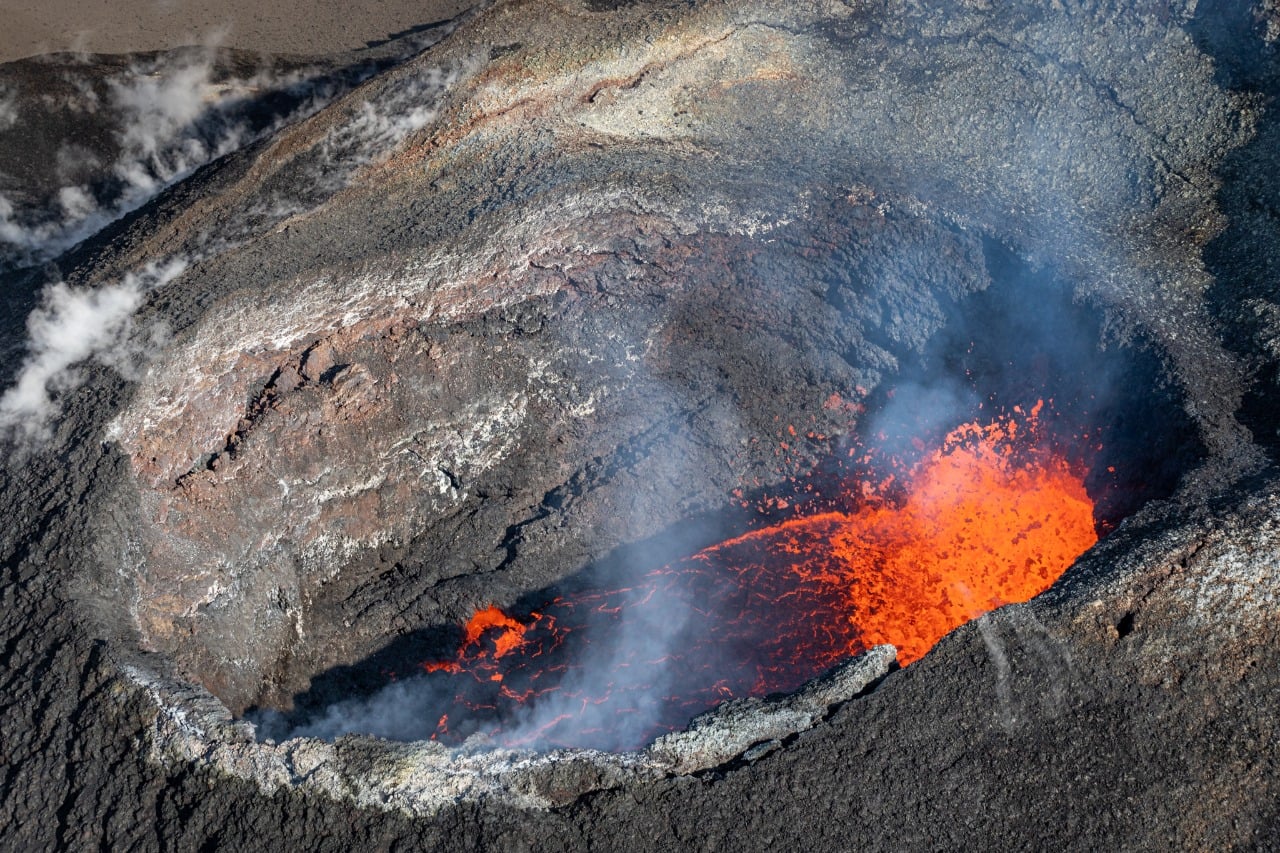
La Réunion Island , Piton de la Fournaise :
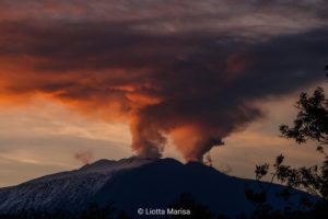
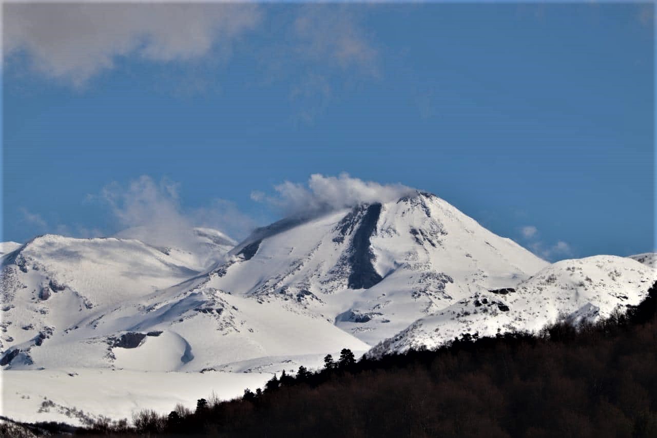
Press release of May 03, 2021 – 3:00 p.m.
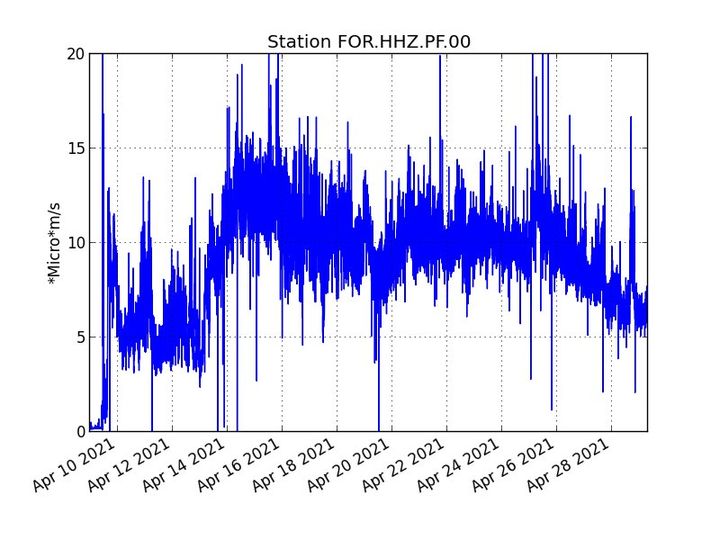
The eruption that started on 04/09/2021 at 7 p.m. (appearance of the tremor) continues. the amplitude of the tremor after having stagnated from April 29 to May 1, resumed its tendency to slowly decrease since May 2. However, its amplitude remains significant, still reaching 50% of the maximum amplitude observed during this eruption on April 13.
– Over the past 24 hours, 6 superficial volcano-tectonic earthquakes (between sea level and the surface) have been recorded, all located directly above the summit craters.
– The CO2 fluxes in the soil are always increasing in the far field (Plains region).
– The slight inflation (swelling) of the summit area and the base of the terminal cone is confirmed. This parameter will be carefully monitored over the next few days because it may correspond to the pressurization of the superficial magmatic reservoir located under the summit and could suggest a deep magma flow entering the upper superficial magmatic reservoir adding to the outlet flow of the reservoir that feeds the eruptive site.
– The improvement in weather conditions on site since yesterday continues, making it possible to observe the eruption from Piton de Bert and more generally from the rampart on the Enclos Fouque.
– An intervention carried out this morning with the support of the SAG and the PGHM, allowed us to observe that the flow front was still located upstream of the Bonnet crater and that it had resumed a slow downstream progress, as well as taking lava samples and restarting a broken seismic station.
– The flow of lava at the exit of the eruptive vents is essentially tunneled and almost to the upper limit of the large slopes.
– The lava fountains, clearly visible until the beginning of the bad weather period, are now much weaker. A small lava lake has taken place inside the upstream eruptive vent, while let the gas plume concentrate on the downstream vent.
– The favorable meteorological conditions allowed an estimation of the lava flow by satellite imagery. Surface flows estimated from satellite data via the HOTVOLC platform (OPGC – Clermont Auvergne University) remain below 7 m3 / s. However, the lava flow, now largely tunneled, probably leads to an underestimation of this flow.
– Note, this morning as yesterday morning, the presence of fires in the vegetation located at the foot of the Nez coupé du Tremblet.
Alert level: Alert 2-2
Source et photo : OVPF
Read the article : https://www.ipgp.fr/sites/default/files/ovpf_20210503_15h00_communique_eruption.pdf
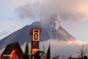
Peru , Sabancaya :
Analysis period: from April 26, 2021 to May 02, 2021, Arequipa, May 03, 2021.
Alert level: ORANGE
The Geophysical Institute of Peru (IGP) reports that the eruptive activity of the Sabancaya volcano remains at moderate levels, that is to say with the recording of an average of 91 daily explosions, with columns of ash and gas up to an altitude of 2.3 km above the summit of the volcano and their consequent dispersion. Therefore, for the following days, no significant change is expected in eruptive activity.
The IGP recorded and analyzed the occurrence of 1703 earthquakes of volcanic origin, associated with the circulation of magmatic fluids inside the Sabancaya volcano. An average of 91 explosions was recorded daily. During this period, Volcano-Tectonic (VT) earthquakes associated with rock fractures were located mainly in the East, and North-East of Sabancaya and presented magnitudes between M1.4 and M2.5.
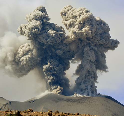
The monitoring of the deformation of the volcanic structure using GNSS techniques (processed with fast orbits) does not present any significant anomalies. However, in general, an inflation process was observed in the northern sector (around the Hualca Hualca volcano). Visual surveillance identified columns of gas and ash up to an altitude of 2.3 km above the summit of the volcano, which were scattered towards the South-West, South, South-West and North-West sectors. West of Sabancaya. Satellite recordings have identified the presence of 11 thermal anomalies (maximum value of 42 MW) associated with the presence of a lava body on the surface of the volcano’s crater.
RECOMMENDATIONS
• Keep the volcanic alert level in orange.
• Do not approach within a radius of less than 12 km from the crater.
Source et photo : IGP.
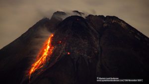
Iceland , Geldingadalur :
Re-evaluation needed of the size of the hazard area ,May 4 ,2021 , Updated May 03 at 12:15
The eruption in Fagradalsfjall continues through one main crater. The active crater is the fifth fissure opening that opened in the area on the 13th of April. Since the 27th of April, the volcanic activity was characterized by continuous lava fountains, while the activity changed at around midnight on the 2nd of May, and has since been showing pulsating behaviour. These pulses have intermittent active periods of 8-12 minutes, with 1-2 minutes of rest periods in between. The active pulses start with a strong fountain activity, with fountains reaching up to 100-150 m above ground level, and some even higher. These pulses are very apparent in the seismic tremor from seismic stations in a wide area around the eruption site.
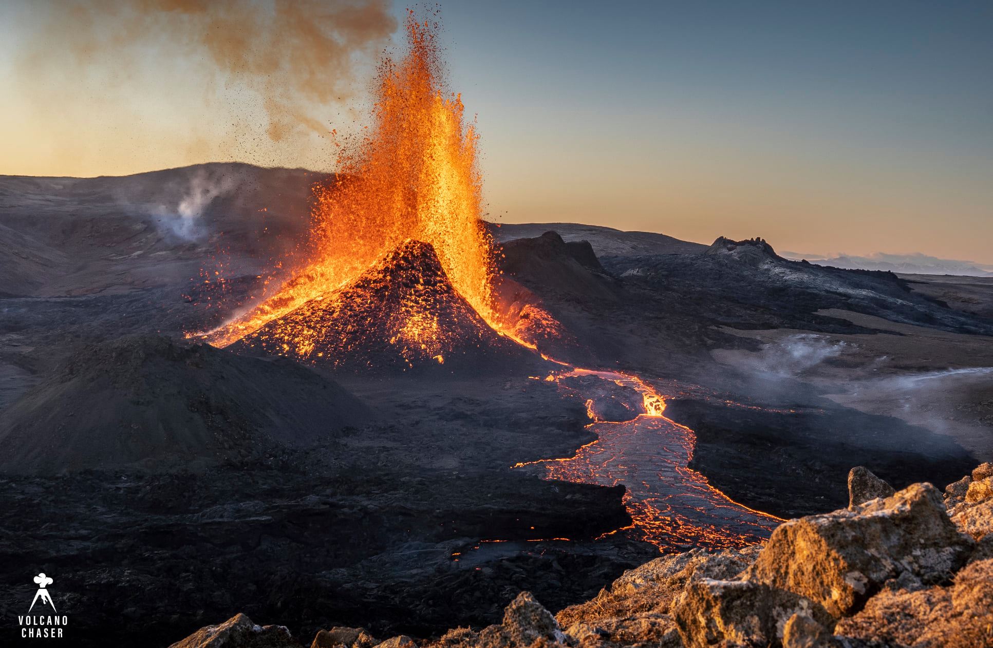
On Sunday morning, just after 6 am, the wind direction changed to slow easterly, and a few hours later smoke was detected in the southwest slopes of Geldingadalir. Possibly, hot pyroxene from the eruptive crater has been carried by the wind to the southwest of the lava field for about 300 meters distance and started a brush fire which can be seen on one of the two RÚV webcams.
It is not clear what is causing these changes in volcanic activity, but changes in magma flow, the chemical composition of magma/gas, or possibly changes in the volcanic conduit cannot be ruled out.
Considering these changes in activity, the size of the hazard area at the eruption site is being re-evaluated.
Source : Vedur is.
Photo : Volcano Chaser / Marco Di Marco .
New Zealand , White Island :
Minor volcanic unrest continues at Whakaari/White Island , Published: Tue May 4 2021 12:30 PM
Despite a short-lived burst of activity on 29 April, volcanic activity at Whakaari/White Island remains at low levels. The Volcanic Alert Level remains at 1.
The brief period of low-energy tremor and acoustic signals was recorded on 29 April at around 2230 NZST as a sequence of small volcanic earthquakes, leading to volcanic tremor. During the period of volcanic tremor impulsive acoustic signals were recorded and this lasted for several hours.
An observation flight on 30 April confirmed there was no ejected material from this seismic activity – unlike in previous episodes when ejected material was seen within metres from the active vent. No observations of changes were seen on the island’s webcams.
This episode is likely caused by a series of low-energy subterranean explosions. Similar periods of activity were observed in mid-February and early-mid March, returning to typical low levels shortly afterwards.
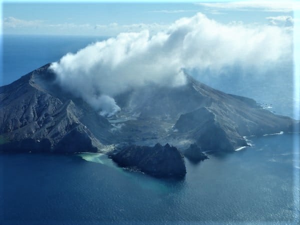
Gas and observation flights have confirmed the amount of gas been released from the volcano is unchanged since March. The volcano continues to produce a moderate gas and steam plume, and this will cause weak acid rain downwind.
The thermal infrared measurements also confirm the temperatures of the active vents are not changing significantly. The level of seismic tremor remains at background levels. These observations and the observed minor activity are consistent with the ongoing activity. The Volcanic Alert Level remains at 1 and the Aviation Colour Code remains at Green.
The Volcanic Alert Level reflects the current level of volcanic unrest or activity and is not a forecast of future activity. While Volcanic Alert Level 1 is mostly associated with environmental hazards (including discharge of steam and hot volcanic gases, earthquakes, landslides and hydrothermal activity) eruptions can still occur with little or no warning. The main plausible triggers for a sudden eruption are the collapse of unstable material in an active vent and the possible ingress of water underground onto the shallow magma body.
Source : Geonet / Brad Scott / Duty Volcanologist.
.
Photo : Geonet.
Chile , Nevados of Chillan :
Special Report on Volcanic Activity (REAV), Ñuble region, Nevados de Chillán volcanic complex, May 2, 2021, 5:15 p.m. local time (Continental Chile)
The National Service of Geology and Mines of Chile (Sernageomin) publishes the following PRELIMINARY information, obtained thanks to the monitoring equipment of the National Volcanic Monitoring Network (RNVV), processed and analyzed in the Volcanological Observatory of the Southern Andes ( Ovdas):
On Sunday 02 May at 16:59 local time (20:59 UTC), the monitoring stations installed near the Nevados of Chillán volcanic complex recorded an earthquake associated with the dynamics of fluids inside the volcanic system (long period type).
The characteristics of the earthquake after its analysis are as follows:
TIME OF ORIGIN: 16:59 local time (20:59 UTC)
REDUCED DISPLACEMENT: 553 (cm * cm)
ACOUSTIC SIGNAL: 2.67 Pascals (Pa) reduced to 1 km
OBSERVATIONS:
Due to the weather conditions in the area, it was not possible to verify the state of the surface activity of the volcanic complex.
The volcanic technical alert remains at the Yellow level.
Source : Sernageomin .
Photo : Reav.
Saint Vincent , Soufrière Saint Vincent :
La Soufrière, St. Vincent SCIENTIFIC UPDATE – 03/05/21 6:00PM
– Seismic activity at La Soufrière, St Vincent has remained low since the tremor associated with the explosion and ash on 22 April.
– In the last 24 hours, only a few long-period, hybrid and volcano-tectonic earthquakes were recorded and there was no further seismic tremor.
– The seismic network recorded signals from multiple lahars for a period of about six hours starting around 9 am.
– These lahars most likely took place in all the valleys around La Soufrière. The most intense lahars occurred between 11 am and 12 noon.
– Measurements of the Sulphur Dioxide (SO2) flux at La Soufrière were carried out with the help of the coastguard off the west coast yesterday. Measurements yielded an average SO2 flux of 1036 tons per day.
– The volcano continues to be in a state of unrest. Explosions with accompanying ashfall, of similar or larger magnitude to those that have already occurred can take place with little or no warning.
– The volcano is at alert level Red.
Source : UWI