
March 20 , 2022.
Alaska , Pavlof :
55°25’2″ N 161°53’37 » W,
Summit Elevation 8261 ft (2518 m)
Current Volcano Alert Level: WATCH
Current Aviation Color Code: ORANGE
Satellite data showed elevated surface temperatures consistent with minor lava effusion at the active east vent near the summit of Pavlof. Seismic tremor continued but no explosions were detected in local and regional infrasound data over the past day.
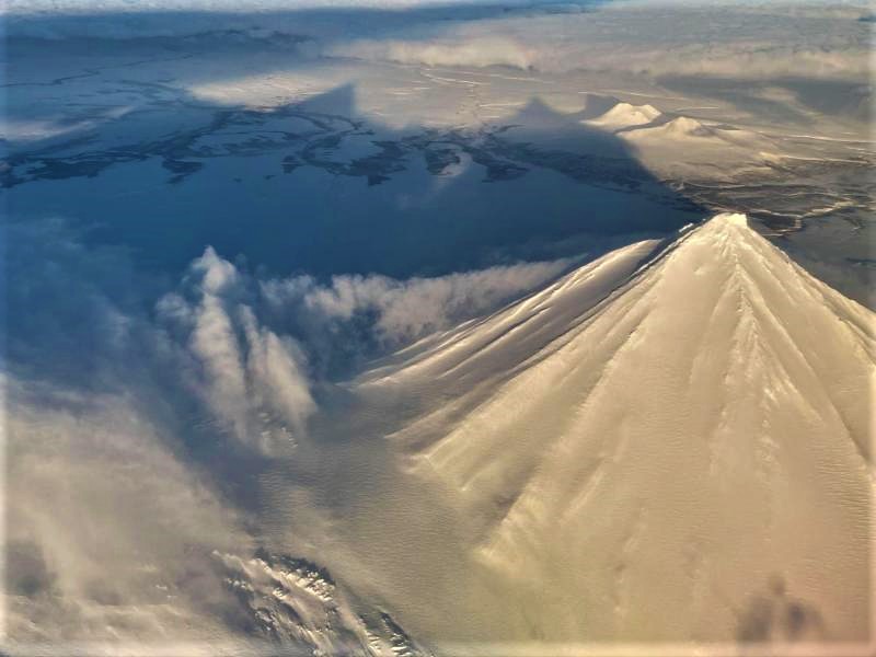
Small explosions associated with the current eruption could happen at any time and may be accompanied by small ash plumes within the immediate vicinity of the volcano. The level of unrest at Pavlof can change quickly and the progression to more significant eruptive activity can occur with little or no warning.
Pavlof is monitored by local seismic and infrasound sensors, satellite data, web cameras, and remote infrasound and lightning networks.
Source : AVO
Photo : Musselwhite, Levi .
La Martinique , Mount Pelée :
Weekly report on the activity of Mount Pelée for the period from March 11 to 18, 2022.
Between March 11, 2022 at 4 p.m. (UTC) and March 18, 2022 at 4 p.m. (UTC), the OVSM recorded at least 4 volcano-tectonic earthquakes of magnitude less than or equal to 0.5. These earthquakes were located inside the volcanic edifice between 0.7 and 1.1 km deep below the surface. This superficial volcano-tectonic seismicity is associated with the formation of micro-fractures in the volcanic edifice.
None of these earthquakes were felt by the population.
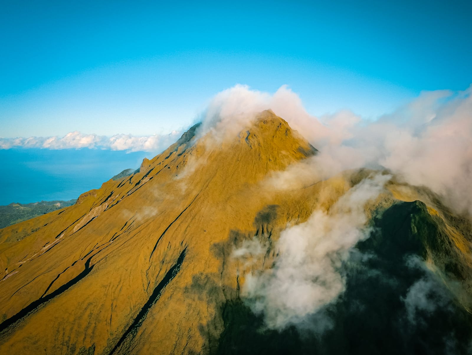
The zone of degassing at sea at shallow depth between St Pierre and le Prêcheur is still observed. The IGP took fluid samples in order to understand the origin of this degassing and to assess its possible relationship with the Mount Pelée hydrothermal system.
An extension of two areas of degraded vegetation located between Morne Plumé and the Chaude River was observed during a helicopter flight carried out on February 9, with the support of the Dragon 972, and confirmed by analysis of satellite images.
The alert level remains YELLOW: vigilance.
Source : Direction de l’OVSM IPGP.
Photo : rci.fm
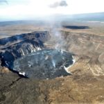
Hawaii , Kilauea :
Summit Elevation 4091 ft (1247 m)
Current Volcano Alert Level: WATCH
Current Aviation Color Code: ORANGE
Activity Summary:
The summit eruption of Kīlauea Volcano, within Halemaʻumaʻu crater, continued over the past 24 hours. The active lava lake surface has had continued circulation over the past 24 hours. Additionally, a lava flow advanced onto the northwest crater floor from noon yesterday through to midnight. Tremor remains elevated above background levels. Summit tilt was inflationary until yesterday afternoon, and deflationary from yesterday evening to about 6:30 a.m. H.S.T. this morning. All recent activity has been confined to the crater, and there are no indications of activity migrating elsewhere on Kīlauea.
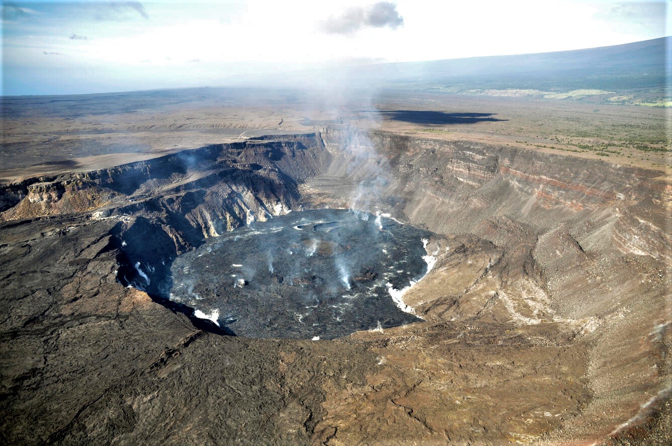
A photograph taken during a helicopter overflight on the morning of March 17, 2022, shows an overview of Halema‘uma‘u and a diffuse plume rising above Kīlauea caldera. A closer look on the western side of the caldera (the foreground of the image, just to the south of the 1982 fissure) shows HVO staff members dressed in orange flight suits performing mission critical work.
Halemaʻumaʻu Lava Lake Observations:
Eruption of lava from the western vent into the active lava lake surface (approximately 2.5% of Halemaʻumaʻu crater floor) continued over the past 24 hours. A lava flow advancing onto the northwest crater floor was active from noon yesterday to midnight. The highest point on the Halemaʻumaʻu crater floor has risen approximately 97 meters (318 feet) since the eruption began on September 29, 2021. The erupted volume is 53.6 million cubic meters (70.1 million cubic yards) of lava as measured on March 4, 2022.
Summit Observations:
Summit tiltmeters recorded inflation until yesterday afternoon, then deflation starting in the evening, which appears to have stopped around 6:30 a.m. H.S.T. this morning. Seismic data shows that the volcanic tremor was elevated and stable until around 3 a.m. H.S.T. this morning, at which point it declined until about 6 a.m. H.S.T. Tremor remains above background levels. A sulfur dioxide (SO2) emission rate of approximately 1900 tonnes per day (t/d) was measured on March 10.
Source : HVO
Photo : USGS / L. Gallant.
Iceland , Reykjanes Peninsula :
Roughly 300 earthquakes were located by the IMO’s SIL seismic network this past week, about 130 less compared to the previous week. The largest earthquake of the week was M2.6 located 10 km NNE of Grímsey on 7th of March and the second largest was M2.4 in Mýrdalsjökull on 10th of March. Nearly 50 earthquakes were located close to Grímsey, thereof five M2.0 or larger. There is still some seismic activity on Reykjanes peninsula, focused on the area between the SW-ern tip of the peninsula and Lake Kleifarvatn. Around 100 earthquakes were located there this week and the three largest were M1.8.
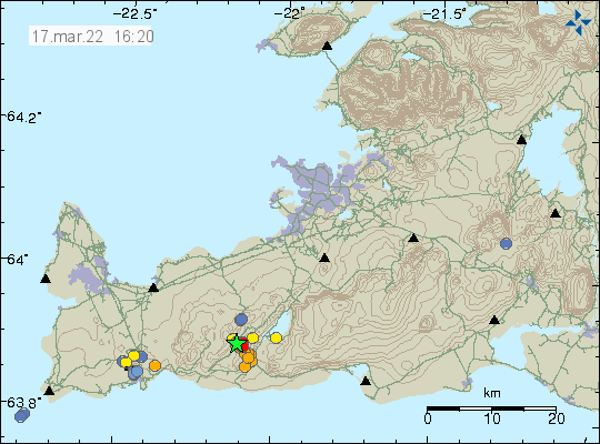
Earthquake swarm in Krýsuvík-Trölladyngja volcano
On 17-March-2022,an earthquake swarm took place in Krýsuvík-Trölladyngja volcano.
Largest earthquake had a magnitude of Mw3,0. Other earthquakes have been smaller in magnitude. Bad weather in last few weeks have prevented good detection of small earthquakes. More earthquake activity might have taken place than appears on Icelandic Met Office maps.
Sources : Vedur is , icelandgeology.net
Photo : Icelandic Met Office.
Guatemala , Fuego :
Weather conditions: Clear weather.
Wind: From the northeast.
Precipitation: 2.50 mm.

ACTIVITY:
The Fuego volcano observatory -OVFGO- reports weak degassing at a height of 4,500 meters above sea level (14,763 feet) which is spreading westward. 5 to 7 weak to moderate explosions are recorded per hour, these generate columns of ash at a height of 4,500 to 4,700 m above sea level (14,763 to 15,419 feet) which extend towards the West. . The explosions produce the descent of weak to moderate avalanches on the contour of the crater towards the Las Lajas, Ceniza and Trinidad ravines, some of them reaching the vegetation. Weak rumblings were generated which cause weak shock waves which vibrate the houses near the volcano. Following the explosions, ashfall continues to be recorded in Panimache I, Morelia, Santa Sofía, El Porvenir, Sangre de Cristo, Yepocapa and other communities. The recommendations of special bulletin BEFGO-015-2022 are still valid.
Source : Insivumeh.
Photo : Diego rizzo .


No comment yet, add your voice below!