July 23 , 2021.
Chile , Nevados de Chillan :
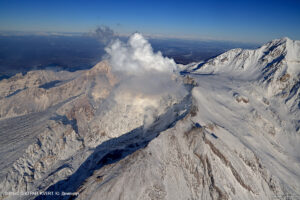
Special Report on Volcanic Activity (REAV), Ñuble region, Nevados de Chillán volcanic complex, July 22, 2021, 1:10 a.m. local time (Continental Chile).
The National Service of Geology and Mines of Chile (Sernageomin) publishes the following PRELIMINARY information, obtained thanks to the monitoring equipment of the National Volcanic Monitoring Network (RNVV), processed and analyzed at the Volcanological Observatory of the Southern Andes ( Ovdas):
On Thursday, July 22, at 04:40 local time (04:40 UTC), monitoring stations installed near the Nevados de Chillán volcanic complex recorded an earthquake associated with fluid dynamics (long period type) in the volcanic system.
The characteristics of the earthquake after its analysis are as follows:
TIME OF ORIGIN: 04:40 local time (04:40 UTC)
LATITUDE: 36.876 ° S
LONGITUDE: 71.379 ° W
DEPTH: 0.2 km
REDUCED DISPLACEMENT: 509 (cm2)
ACOUSTIC SIGNAL: 2.33 Pascals (Pa) reduced to one km
The characteristics of the surface activity are as follows:
MAXIMUM HEIGHT OF THE COLUMN: 300 meters above the point of emission
DIRECTION OF DISPERSAL: East (E)
OBSERVATIONS:
The volcanic technical alert remains at the Yellow level.
Source : Sernageomin.
Photo : Josefauna
Colombia , Nevado del Ruiz :
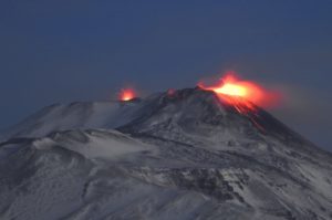
Weekly activity bulletin of the Nevado del Ruiz volcano.
The activity level continues at: Yellow activity level or (III): Changes in the behavior of volcanic activity.
Regarding the monitoring of the activity of the Nevado del Ruiz volcano, the COLOMBIAN GEOLOGICAL SERVICE reports that:
Seismicity linked to fluid dynamics, inside volcanic conduits, increased in number of events and in seismic energy released compared to the previous week. This seismic activity was characterized by the appearance of continuous volcanic tremor, tremor pulses, long and very long period earthquakes, which exhibited varying energy levels and spectral content. The earthquakes were located mainly in the Arenas crater. Some of these signals were associated with ash emissions, confirmed by IP cameras installed in the volcano area and by SGC officials. During the last week the dispersion and the fall of the ashes were notably influenced by the meteorological conditions, the wind regime showed a preferential direction towards the West-North-West and West-South-West.
The seismicity generated by the fracturing of the rock increased in number of earthquakes and in seismic energy released, compared to the previous week. This seismic activity was located mainly in the South-South-West sectors and the Arenas crater. The depths of the earthquakes ranged from 0.4 to 5.5 km. An increase in this type of seismicity emerged on July 14, the earthquakes were located about 3.3 km south-southwest of the Arenas crater at depths that varied between 2.8 and 4.2 km. The maximum magnitude recorded during the week was 1.8 ML (local magnitude), corresponding to the earthquake recorded on July 14 at 09:41 (local time), located 3.6 km southwest of the Arenas crater, 3.7 km deep.
Regarding the « drumbeat » type seismicity, there were several episodes of low energy level associated with the fracturing of the rock on July 13, 14 and 17. This seismicity has been linked to the processes of ascent, location-growth and evolution of a lava dome at the bottom of the crater.
Source et photo : SGC.
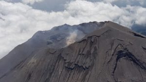
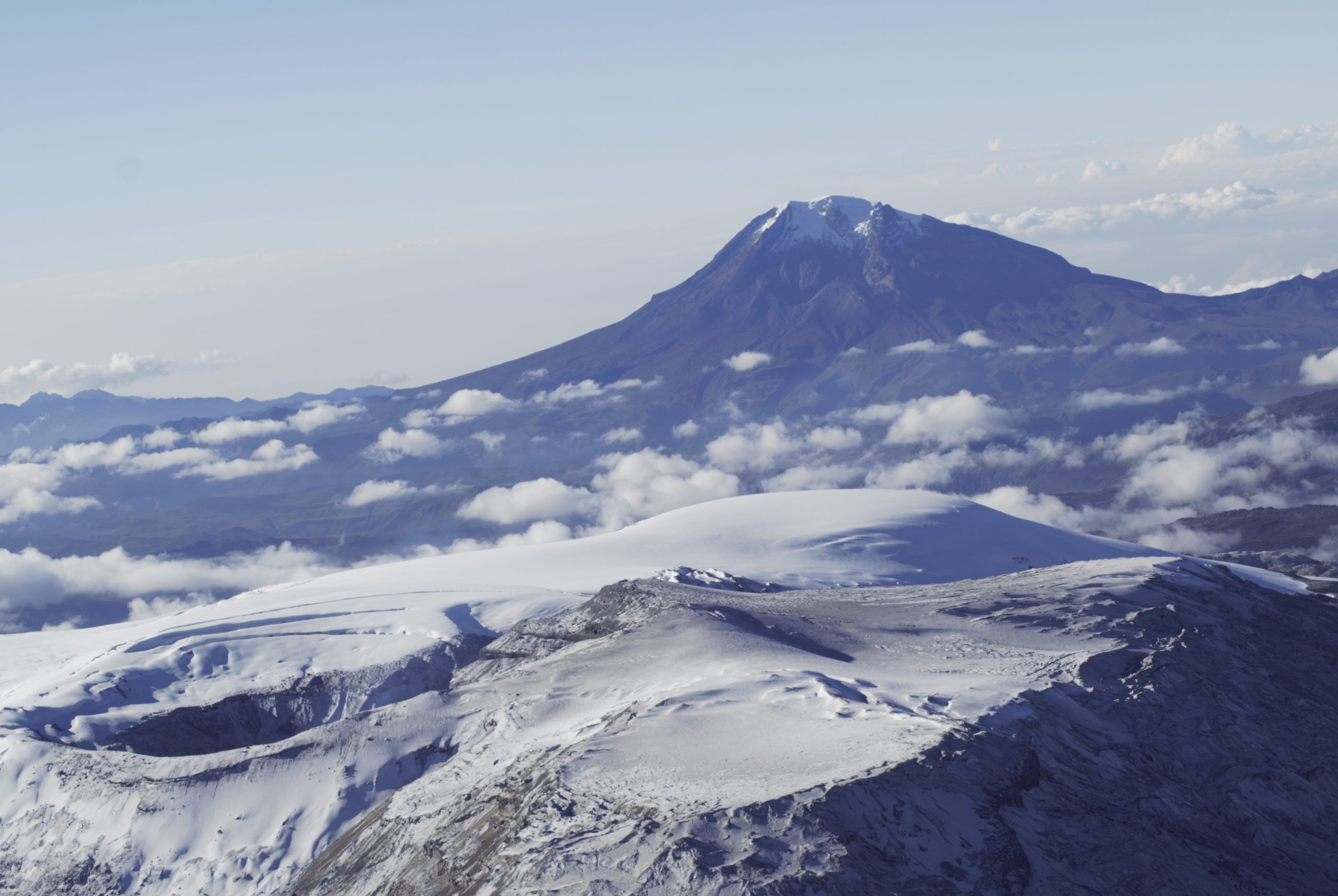
Iceland , Geldingadalur / Fagradalsfjall :
The fissure eruption in the W part of the Krýsuvík-Trölladyngja volcanic system, close to Fagradalsfjall on the Reykjanes Peninsula, continued during 14-20 July. Lava fountaining and overflows from the fifth vent were sometimes visible, and lava from the crater flowed in tubes as well as on the surface. Visible activity at the vent occasionally paused for various lengths of time. The Aviation Color Code remained at Orange due to the lack of ash and tephra emissions, though IMO warned of the potential for lapilli and scoria fallout within a 650 m radius of the active vent. Authorities warned of increased gas emissions hazards.

Deep earthquakes in Fagradalsfjall mountain
Today (21-July-2021) few deep earthquakes took place in Fagradalsfjall mountain that is part of Krýsuvík-Trölladyngja volcano system.
This earthquake activity was not big and the largest magnitude recorded was a magnitude of Mw0,8. Most depth that appeared had a depth of 13,4km.
It is difficult to know what this means. What is possibly happening is that more magma is pushing up in the magma feeding that now exist where the eruption has been happening. If that is happening, it can result in new craters or fissure opening up and start erupting. At the writing of this article this earthquake activity seems to be ongoing, but at slow rate and small earthquakes only so far.
Source : GVP. Icelandgeology.net
Photo : mbls webcam
Philippines , Taal :
TAAL VOLCANO BULLETIN: 23 July 2021 8:00 AM
In the past 24-hour period, the Taal Volcano Network recorded ninety-five (95) volcanic earthquakes, including sixty-eight (68) volcanic tremor events having durations of one (1) to seventeen (17) minutes, twenty-six (26) low-frequency volcanic earthquakes, one (1) hybrid earthquake and low-level background tremor that has persisted since 07 July 2021.
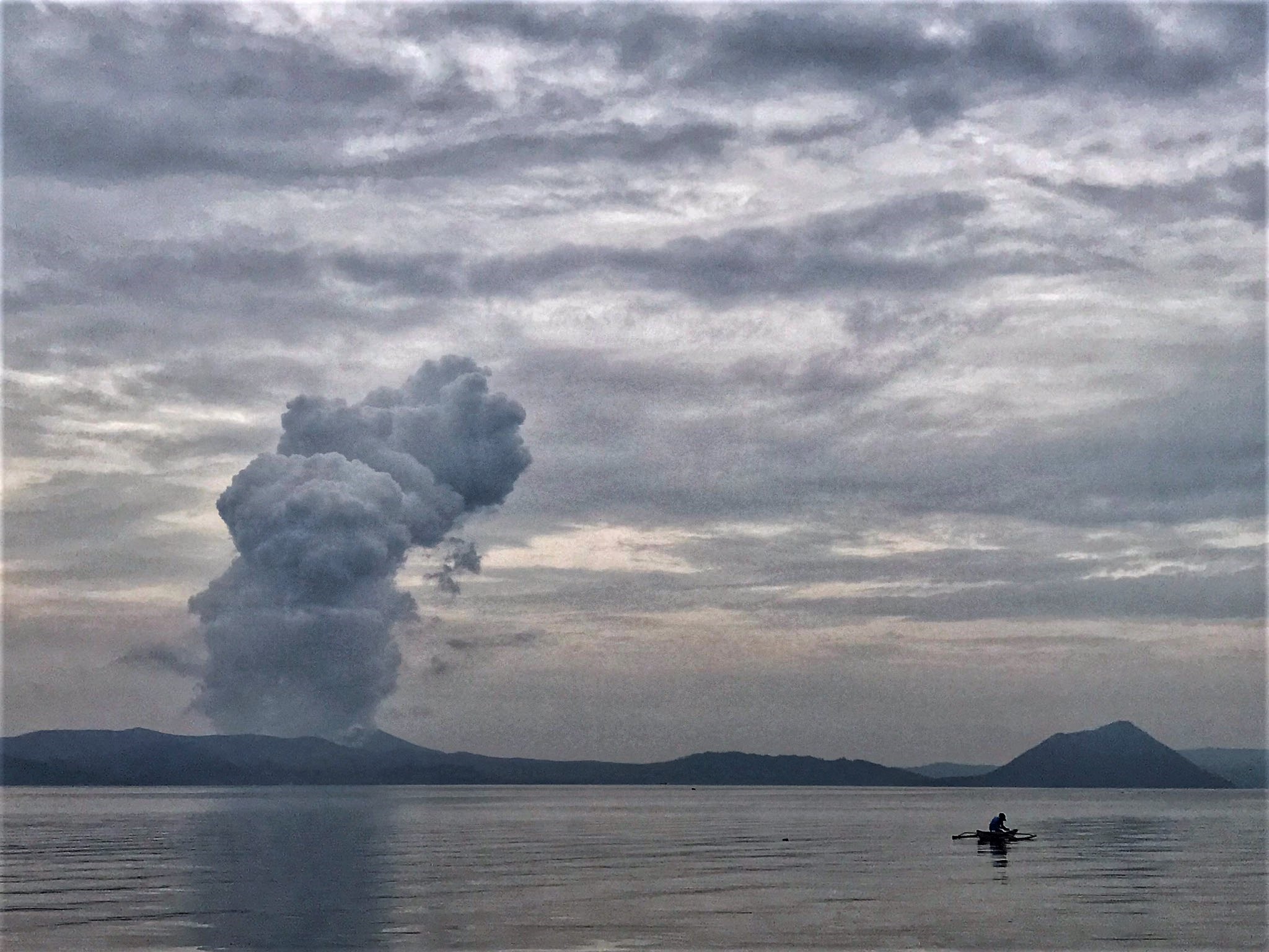
High levels of volcanic sulfur dioxide or SO2 gas emissions and steam-rich plumes that rose nine hundred (900) meters before drifting to the northeast and east were generated from the Taal Main Crater. Sulfur dioxide (SO2) emission averaged 5,286 tonnes/day on 20 July 2021. Based on ground deformation parameters from electronic tilt, continuous GPS and InSAR monitoring, Taal Volcano Island has begun deflating in April 2021 while the Taal region continues to undergo very slow extension since 2020.
Source : Phivolcs
Photo : Rizal M
Ecuador , Sangay :
DAILY REPORT ON THE STATE OF SANGAY VOLCANO.
Surface activity level: High, Surface trend: No change.
Internal activity level: High, Internal trend: No change.
Seismicity: From July 21, 2021, 11:00 a.m. to July 22, 2021, 11:00 a.m :
The reference seismic station remains operational, the seismic statistics are complete.
Explosion (EXP) 2
Long period (LP) 17
Tremors of emission (TREMI) 5
Lahars: 1
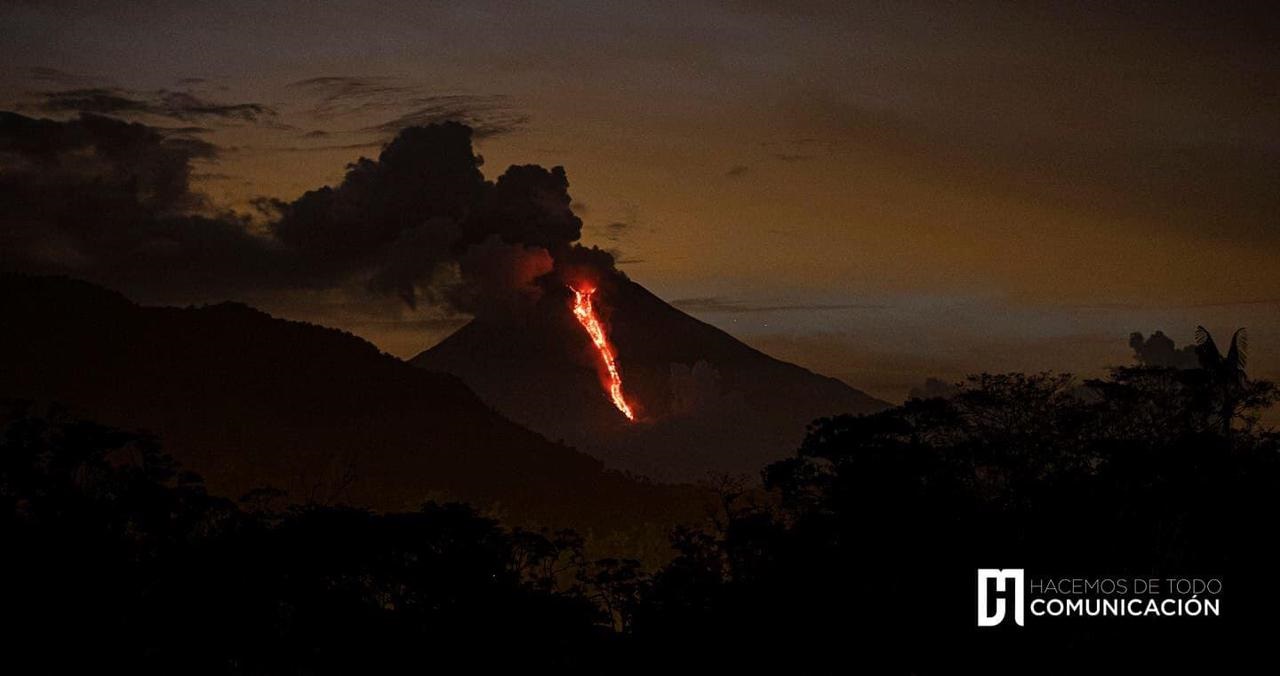
Emission column / ash:
No emissions were observed by the cameras. However, the VAAC recorded 3 ash emission alerts observed by the satellites which reached heights of 900 and 1500 meters above the crater level in a southwest direction.
Rains / Lahars:
On the night of yesterday, moderate rains were recorded in the area of the volcano.A high frequency signal was observed, probably associated with the appearance of mudslides and debris (lahars) which descend into the ravines of the volcano. volcano. ** In the event of heavy rains, these could re-mobilize the accumulated material, generating mudslides and debris that would descend on the sides of the volcano and flow into the adjacent rivers. *
Other monitoring parameters:
No thermal alerts have been recorded in the last 24 hours.
Observation:
The cloudiness was permanent in the area, preventing direct observation of surface activity.
Alert level: yellow.
Source et photo : IGEPN.
Mexico , Popocatepetl :
July 22, 11:00 a.m. (July 22, 4:00 p.m. GMT)
During the last 24 hours, according to the monitoring systems of the Popocatépetl volcano, 82 exhalations have been identified, some of them accompanied by water vapor, gas and light amounts of ash. Today at 4:01 am, a minor explosion was recorded, the column height of which reached 900 m and dispersed towards the West, incandescent fragments were observed at short distance. The National Center for Communication and Operation of Civil Protection (CENACOM) reported a slight fall of ash in the municipalities of Tlalnepantla, Totolapan and Huitzilac in the state of Morelos.
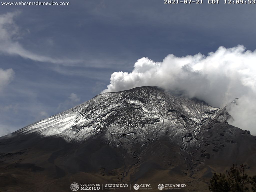
At the time of this report, there is no visibility towards the volcano due to adverse weather conditions. In the early morning, a constant emission was observed in the westerly direction.
CENAPRED recommends NOT to approach the volcano and especially the crater, because of the danger of falling ballistic fragments and, in the event of heavy rains, to stay away from the bottom of the ravines because of the danger of mudslides.
The Popocatépetl volcanic traffic light is in PHASE 2 YELLOW.
Source et photo : Cenapred .