January 13 , 2021 .
Italy / Sicily , Etna :
Weekly bulletin from January 04, 2021 to January 10, 2021, (issue date January 12, 2021)
SUMMARY OF THE STATE OF ACTIVITY.
In the light of surveillance data, it is highlighted:
1) VOLCANOLOGICAL OBSERVATIONS: Strombolian activity of variable intensity associated with ash emissions at the Southeast crater. Strombolian activity within the crater at the Northeast crater, at the Voragine and at the Bocca Nuova with sporadic emissions of diluted ash.
2) SEISMOLOGY: low seismic activity of fracturing; amplitude of the volcanic tremor mainly at the average level.
3) INFRASON: moderate infrasound activity
4) DEFORMATIONS: No significant variation to report for the deformations measured by the inclination and GNSS networks.
5) GEOCHEMISTRY: SO2 flux: medium-high level
HCl flux occurs at a high level
The CO2 flux from the soil is at average levels.
The partial pressure of dissolved CO2 does not show significant changes.
There are no updates for the C / S report.
The helium isotope ratio is at average values (last update 08/01/2021).
6) SATELLITE OBSERVATIONS: The thermal activity in the summit area is at a medium-low level.
VOLCANOLOGICAL OBSERVATIONS
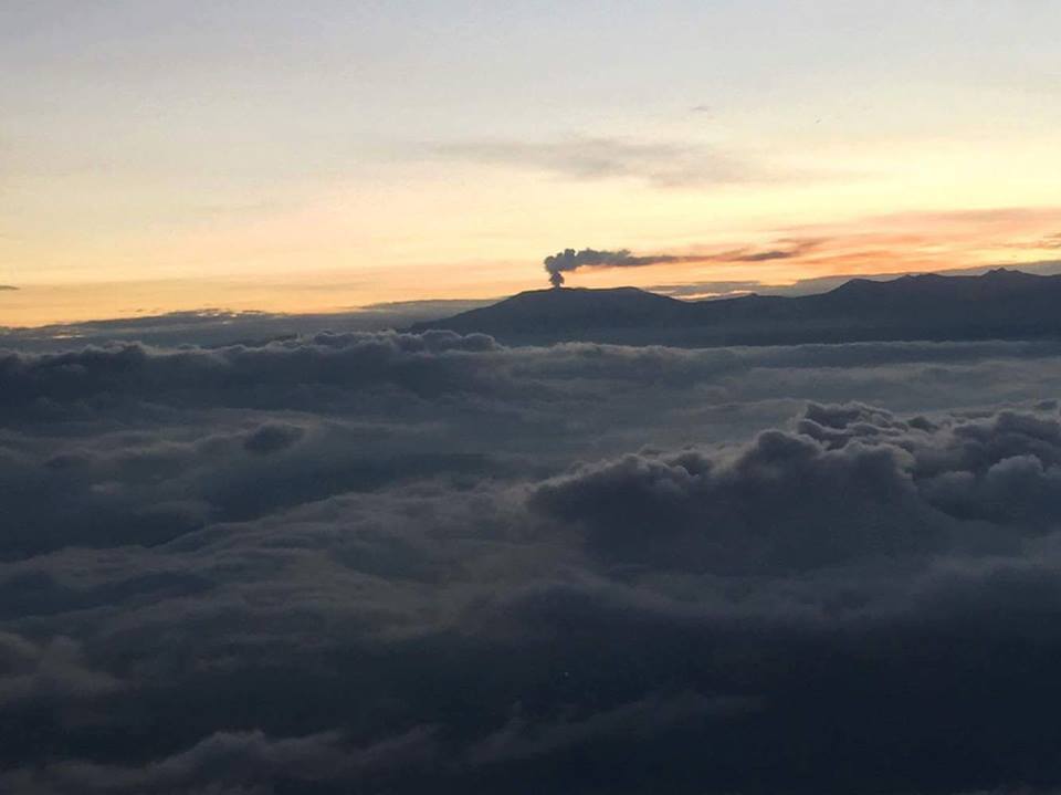
The monitoring of the volcanic activity of Etna, during the week in question, was carried out by analyzing the images of the network of surveillance cameras of the INGV, Etneo Observatory (INGV-OE). The bad weather conditions made the observation of the volcanic activity discontinuous thanks to the network of cameras.
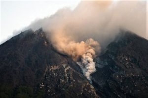
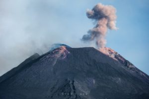
During the period examined, the activity of Etna had a behavior quite similar to that observed the previous week with a Strombolian activity varying in intensity and frequency at the Southeast Crater (SEC), which produced emissions of ash from weak to weak / abundant, and throwing shreds of lava falling on the sides of the crater. The Northeast (NEC), Bocca Nuova (BN) and Voragine (VOR) craters produced intracrater Strombolian activity of varying intensity accompanied by sporadic emissions of dilute ash.
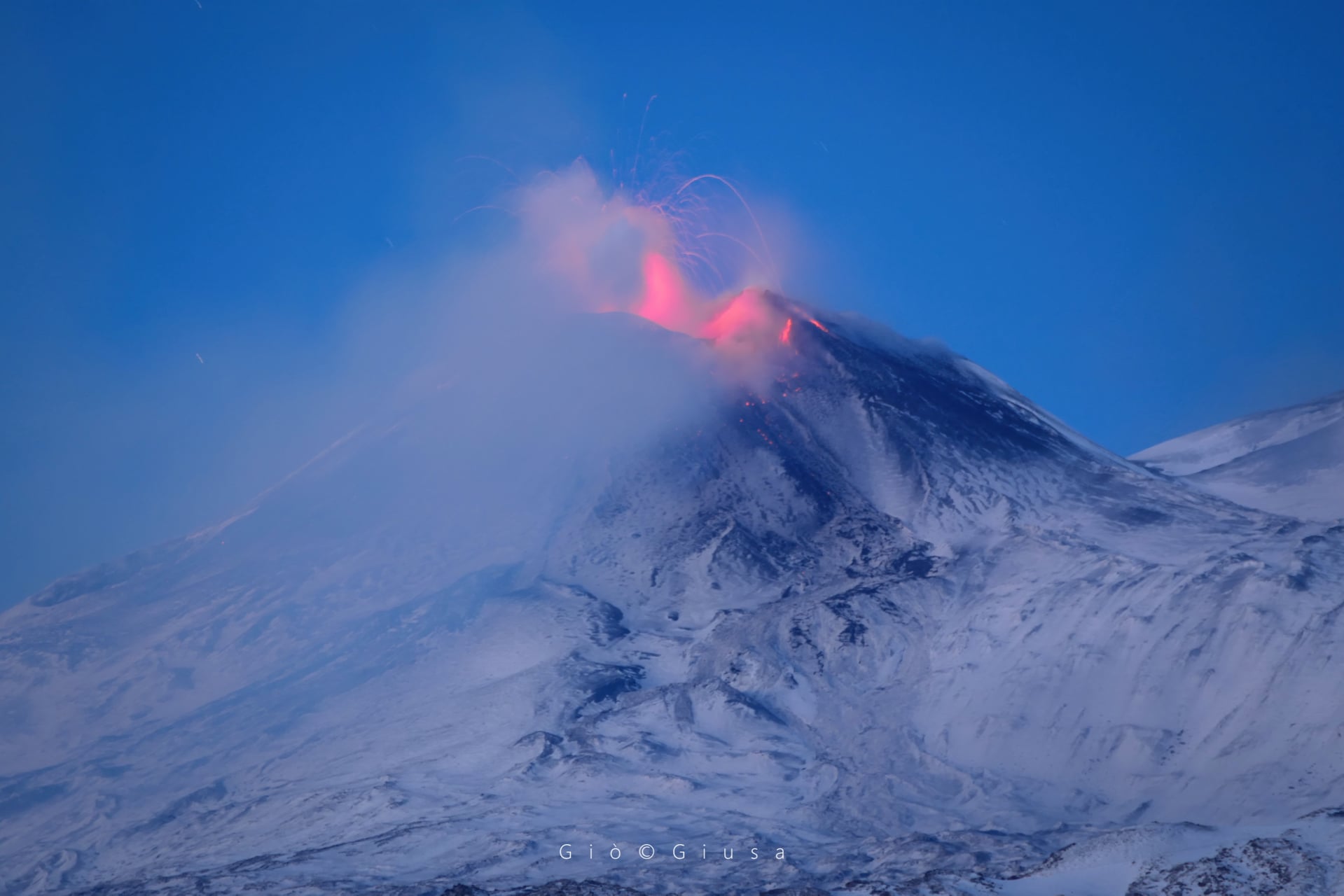
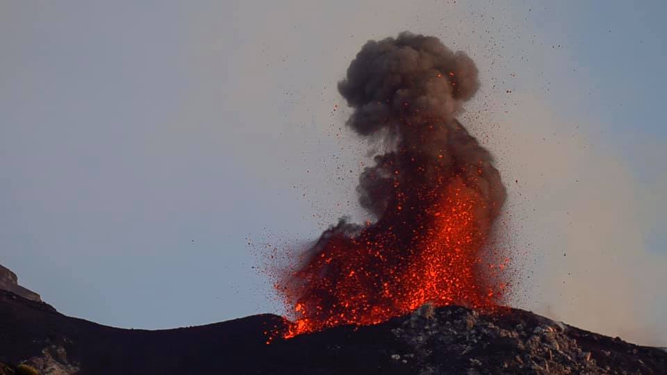
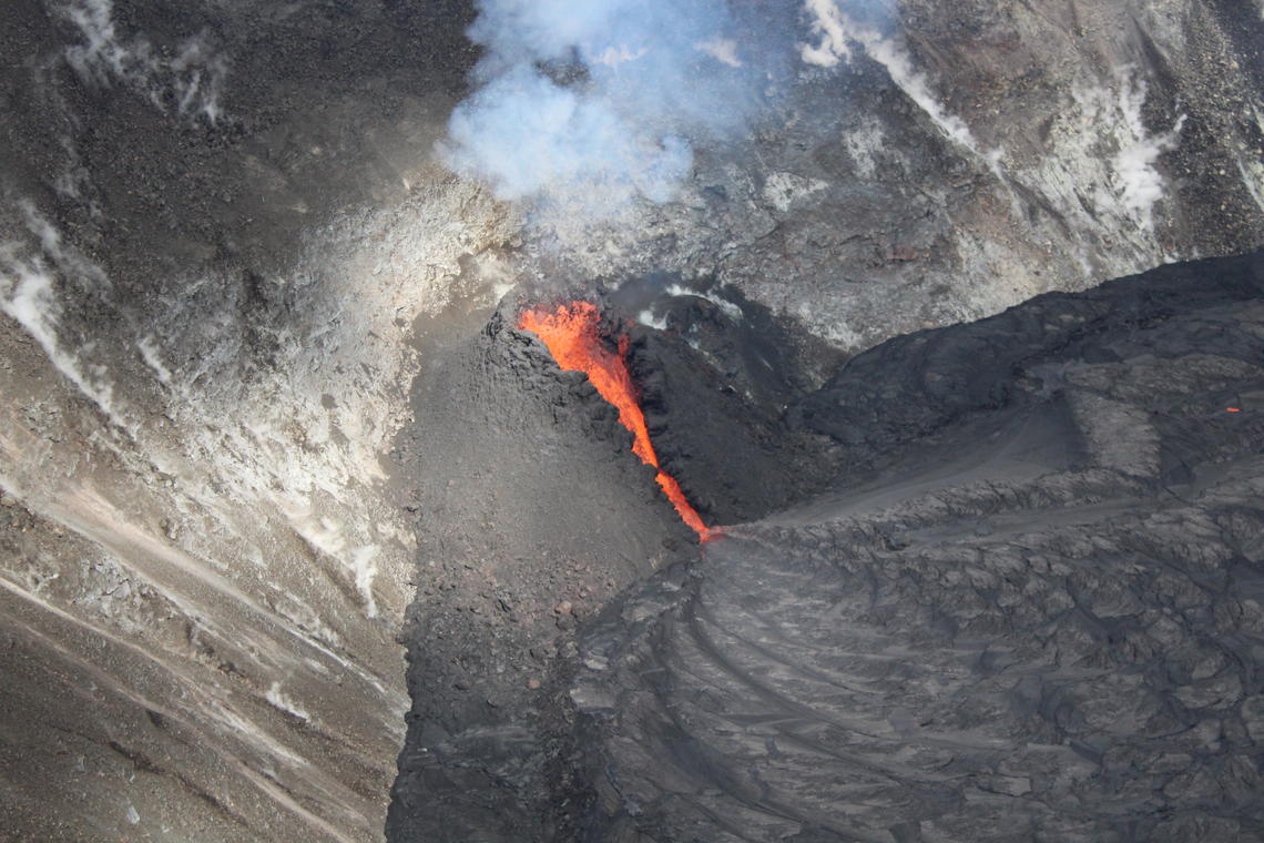
The Southeast Crater (SEC) in particular was characterized throughout the week by Strombolian activity that varied greatly in intensity and frequency. At least 2 episodes of increased Strombolian activity were observed (January 4 and 6) with abundant and continuous emission of dense ash. During the most energetic phases, the launches of coarse materials exceeded the edge of the crater and the products fell, settling outwardly on the sides of the crater.
As for the other craters, it was possible to observe that the intracrater Strombolian activity continued at Bocca Nuova (BN), at Voragine (VOR) and and at the Northeast Crater (NEC) with sporadic emissions of very diluted ash.
Volcanic tremor:
During the period considered, the amplitude of the volcanic tremor remained in the medium amplitude range, although with fluctuations that in recent days also reached the high range. The source of the tremort was constantly located in the area of the Southeast crater, at a depth of about 2700-2900 m above mean sea level
Source : INGV .
Photos : Boris Behncke , Gio Giusa.
Italy : Stromboli :
Weekly bulletin from January 04, 2021 to January 10, 2021, (issue date January 12, 2021)
SUMMARY OF THE STATE OF ACTIVITY
In the light of surveillance data, it is highlighted:
1) VOLCANOLOGICAL OBSERVATIONS: Normal explosive volcanic activity of Strombolian type with splashing in the North zone. The frequency of events showed medium-low levels (less than 10 events / h) until January 6. After growing rapidly, it reached medium-high levels (18 events / h) on January 7 and 8 while in the last days of the period (January 9-10) it showed average levels (12-14 events / h). The intensity of the explosions was mainly medium-low in the area
North and medium-high crater in the Center-South zone.
2) SEISMOLOGY: The seismological parameters do not show significant variations.
3) DEFORMATIONS: No significant change recorded by tilt and GNSS networks
4) GEOCHEMISTRY: SO2 flux: medium level
C / S Ratio – There is no updated data to date: the last available values referring to 06-12-2020 are on average levels (C / S = 12.1).
The isotopic ratio of Helium is located at fairly high values (R / Ra = 4.4 compared to the sampling
December 21).
5) SATELLITE OBSERVATIONS: The thermal activity in the summit area is at a low level.
VOLCANOLOGICAL OBSERVATIONS
In the period under observation, the eruptive activity of Stromboli was characterized by the analysis of the images recorded by the surveillance cameras INGV-OE located at 190 m, Punta Corvi and 400 m.
In the area of the North crater, the N1 crater, with two emission points, produced low intensity explosions (less than 80 m high) emitting fine materials (ash) mixed with coarse materials (lapilli and bombs) . Vent N2, with four emission points, showed mainly low and medium intensity explosive activity (less than 150 m in height) emitting coarse materials. In addition, a projection activity was observed at the mouth of the N2 which for long periods was intense, reaching its maximum on January 7 and 8, then gradually decreasing until it became weak and occasional. The average frequency of the explosions varied from 7 to 12 events / h.
In the Center-South zone, the explosions were produced by at least two vents, one of which emitted only ash and the other only large volumes of coarse incandescent material of medium to high intensity (the products reached 250 m high). The explosive activity showed hourly frequency values ranging from almost zero (until January 5) to 8 events / hr, reached on January 8.
Source : INGV.
Photo : Archive web cam
Colombia , Nevado del Ruiz :
Nevado del Ruiz volcano activity level bulletin.
The activity level continues at the yellow activity level or (III): changes in the behavior of volcanic activity.
Regarding the monitoring of the activity of the Nevado del Ruiz volcano, the COLOMBIAN GEOLOGICAL SERVICE reports that:
Seismicity generated by rock fracturing increased in the number of earthquakes and in the seismic energy released, compared to the previous week. This seismic activity was located mainly in the south-eastern sector of the volcano and in the Arenas crater. To a lesser extent and in a dispersed manner, a seismicity of this type was recorded in the North-East, South and South-West sectors of the volcano.
The depths of the earthquakes ranged from 0.5 to 7.0 km. The seismic increase recorded on January 10 stands out. The highest magnitude recorded during the increase and this week was 2.2 ML (local magnitude), corresponding to the earthquake that occurred on January 10 at 6:45 p.m. local time, located 3.2 km au South-South-East, at a depth of 3.5 km.
Seismicity related to fluid dynamics inside volcanic conduits decreased in the number of events and in the seismic energy released, compared to the previous week. This seismic activity was characterized by the occurrence of continuous volcanic tremor, tremor pulses, long and very long period type earthquakes, which presented variable energy levels and spectral content.
During the week, there was a minor episode of low energy « drumbeat » type seismicity associated with fluid dynamics within the volcanic conduits.
Source : SGC.
Photo : Diana M Bustamante.
Ecuador , Sangay :
DAILY REPORT OF THE STATE OF THE SANGAY VOLCANO, Tuesday January 12, 2021.
Surface activity level: High, Surface trend: Increasing.
Internal activity level: High, Internal trend: Increasing.
Seismicity: From January 11, 2021, 11:00 a.m. to January 12, 2021, 11:00 a.m .:
Long period type events (LP): 21
Explosions (EXP): 39
Emission tremor (TREMI): 5
Lahars (LH): 2
Rains / lahars:
During the night of yesterday and tomorrow today, several episodes of rain generated signals associated with mudslides and debris.
** In case of heavy rains, lahars can be generated in the Volcán, Upano rivers and other tributaries **

Emission / ash column: In the afternoon of yesterday, between the clouds, an emission of gas and ash was observed with a height of about 2000 meters above the level of the crater in a North-West direction. In the past 24 hours, the Washington VAAC reported 4 emissions observed by satellites, with recorded heights approaching 2000 and 2400 meters above crater level and the direction of these emissions was west.
Other monitoring parameters: For this report, no thermal alert has been recorded by the satellites during the last 24 hours for the Sangay volcano.
Observations: The climatic conditions of the area prevented direct observations of surface activity. At the end of this bulletin, there was no report of an ash fall.
Alert level: yellow.
Sources : INSTITUT GÉOPHYSIQUE / ÉCOLE NATIONALE DE POLYTECHNIQUE.
Photo : Yong Soo Seung.
Hawaii , Kilauea :
19°25’16 » N 155°17’13 » W,
Summit Elevation 4091 ft (1247 m)
Current Volcano Alert Level: WATCH
Current Aviation Color Code: ORANGE
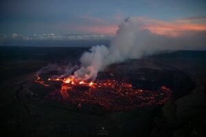
During this morning’s overflight of Halema‘uma‘u, favorable conditions allowed HVO scientists to get clear views of the active western fissure within the crater. A spatter cone of dark fresh lava has built around both the fountaining vent and its turbulent outflow channel down to the lava lake
Activity Summary:
Lava activity is confined to Halemaʻumaʻu with lava erupting from vents on the northwest side of the crater. This morning (Jan. 12), the lava lake is about 196 m (643 ft) deep below the west vents while remaining stagnant over its eastern half. SO2 emission rates were still elevated.
Summit Observations:
The most recent sulfur dioxide emission rate measurements were 2,500 t/d on Monday (Jan. 11)–at the low end or below the range 3,000-6,500 t/d since Dec. 27 (the same range of emission rates from the pre-2018 lava lake). Summit tiltmeters recorded continuing inflationary tilt. Seismicity remained elevated but stable, with steady elevated tremor and a few minor earthquakes.
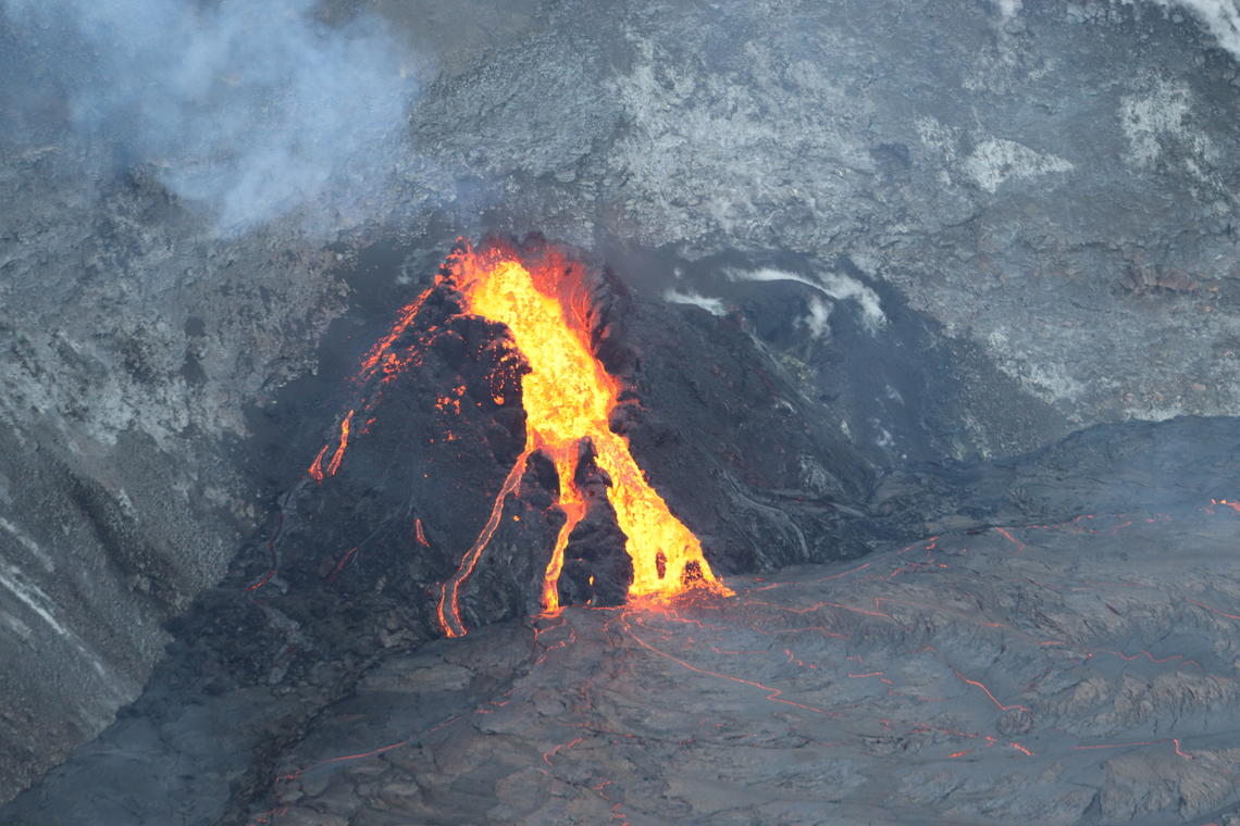
A wider view of the western fissure, and the western end of the lava lake at Kīlauea Volcano’s summit. For scale, the top of the fountain is about 40 m (131 ft) above the lake surface.
Halemaʻumaʻu lava lake Observations:
The west vents exhibited low fountaining that fed lava flows and channels from the top of small cones plastered on the northwest wall of Halemaʻumaʻu crater into the lake.
The lava lake was about 196 m (643 ft or 214 yds) deep below the west vents this morning (Jan. 12) while the stagnant eastern half of the lake was about 4 m (4 yds) shallower. The eastern part of the lake appeared to have subsided below its perched rims.
Source : HVO.
Photos : USGS, M. Zoeller , USGS , M. Patrick.