February 01 , 2019.
Indonesia , Merapi :
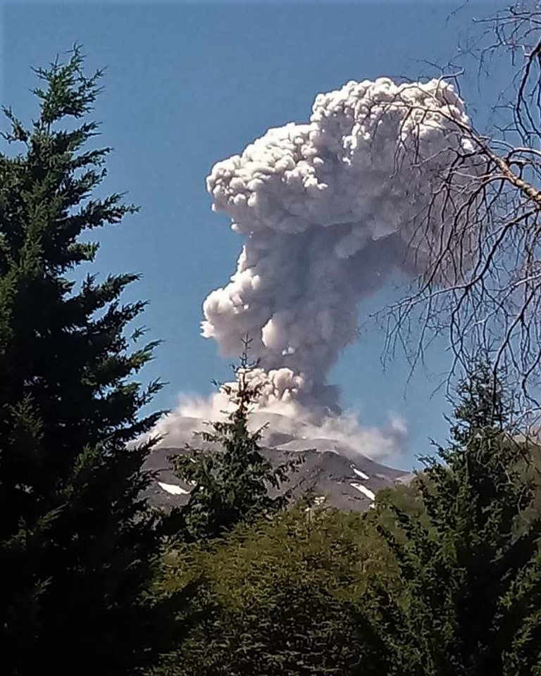
The Mount Merapi volcano in Yogyakarta has being spewing hot ash for the past few days, for the first time since the authorities set the alert level at waspada (caution), the second-highest level in the four-tiered alert system in the country, on May 22, 2018.
“The monitoring post first recorded hot ash emissions on Tuesday evening. The first emission reached 1,400 meters and it lasted for 141 seconds,” Hanik Humaida, the head of research and technological development for the Geological Disaster Agency (BPPTKG), said on Wednesday.
The second emission, Hanik went on to say, reached 1,350 meters over a period of 135 seconds, while the third reached 1,100 meters for 111 seconds.
“The hot ash fell on the upstream of the Gendol River,” she said.
Thick smoke billows from Mount Merapi on the border between Yogyakarta and Central Java on Monday morning. Ash is reported to have fallen in several places in nearby Klaten regency.
Hanik reiterated that the authorities would maintain the volcano’s alert level and would not immediately upgrade it to a higher level.
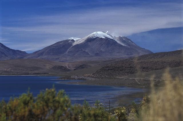
Mt Merapi, some 2,900 meters in height, has built a 461,000 cubic meter lava dome since Jan. 21. The agency has also recorded low scale earthquakes and volcanic material avalanches.
However, Hanik gave an assurance that the latest development were not a threat to local residents living on Merapi’s slopes, while warning them to steer clear of a 3-kilometer radius of the peak of the mountain.
Source : Jakartapost.
Photo : Tarko sudiarno
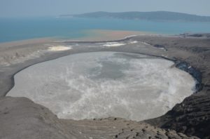
Chile , Guallatiri :
Special Report on Volcanic Activity (REAV)
Region Of Arica and Parinacota, Guallatiri Volcano, January 31 2019, 09h00 Local Time (Continental Chile)
The National Geological and Mining Service of Chile (Sernageomin) publishes the following PRELIMINARY information, obtained from monitoring equipment of the National Volcanic Monitoring Network (RNVV), processed and analyzed at the Volcanological Observatory of the Southern Andes (OVDAS) :
On Thursday, January 31, 2019 at 09:00 local time (12:00 UTC), the monitoring stations installed near the Guallatiri volcano recorded an earthquake associated with a mechanism of fracturing rocks (volcano-tectonic type) inside the volcanic building. This event was located 11.5 km southwest of the main crater.
The characteristics of the earthquake after its analysis are as follows:
TIME OF ORIGIN: 09h00 Local time (GMT-3)
LATITUDE: 18.482 ° S
LONGITUDE: 69.179 ° W
DEPTH: 10.8 KM
LOCAL MAGNITUDE: 3.4 (Ml)
OBSERVATIONS:
After recording the seismic event, other seismic events of lower magnitude were recorded.
The level of volcanic technical alert remains at the level: GREEN.
Sernageomin continues online monitoring and will inform in a timely manner about any changes observed.
Source : Sernageomin.
Photo : Lee Siebert, 2004 (Smithsonian Institution).
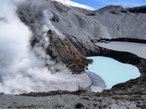
Chile , Nevados de Chillan :
Nuble Region, Nevados of Chillan Volcano, January 31 2019, 15:30 local time (mainland Chile)
The National Geological and Mining Service of Chile (Sernageomin) publishes the following PRELIMINARY information, obtained from monitoring equipment of the National Volcanic Monitoring Network (RNVV), processed and analyzed at the Volcanological Observatory of the Southern Andes (OVDAS) :
On Thursday, January 31, 2019 at 15:09 local time (18:09 UTC), monitoring stations installed near the Nevados volcano of Chillan recorded a long period type earthquake (LP), which was associated with the dynamics of fluids inside. of the volcanic system.
The characteristics of the earthquake after its analysis are as follows:
TIME OF ORIGIN: 15h09 Local time (18h09 UTC)
LATITUDE: 36,862 ° S
LONGITUDE: 71.377 ° W
DEPTH: 1.1 KM
REDUCED MOVEMENT: 910 cm2
ACOUSTIC SIGNAL: 64 Pa reduced to 1 KM
OBSERVATIONS:
After this event, small explosions were recorded. This activity corresponds to the settings recorded during this last period.
The level of volcanic technical alert remains at the level: ORANGE.
Sernageomin continues online monitoring and will inform in a timely manner about any changes observed.
Source : Sernageomin.
Photo : Ovdas
Colombia , Chiles / Cerro Negro :
Weekly activity bulletin of Chiles and Cerro Negro volcanoes
The activity level of volcanoes continues at the level: YELLOW LEVEL ■ (III): CHANGES IN THE BEHAVIOR OF THE VOLCANIC ACTIVITY.
Following the activity of the CHILE volcanoes and CERRO NEGRO, the COLOMBIAN GEOLOGICAL SERVICE (SGC) reports that:
For the period evaluated between January 22nd and 29th, 2019, seismic activity in the Chiles – Cerro Negro volcano region recorded an increase in the number of events compared to the previous week, from 1106 to 3698 earthquakes , most of them cataloged as volcano-tectonic types associated with fractures of rock materials in the volcanic building.
Most of these earthquakes were located southwest of the Chiles volcano, at epicentral distances up to 7 km, with depths between 1.5 and 5 km below the summit (4700 m altitude). The maximum local magnitude reached was M 2.2 on the Richter scale.
Other geophysical and geochemical parameters of volcanic monitoring did not show significant variations.
The COLOMBIAN GEOLOGICAL SERVICE is attentive to the evolution of the volcanic phenomenon and will continue to inform in a timely manner of the observed changes.
Source : SGC.
Photo : Boriss Andean / Summit post.
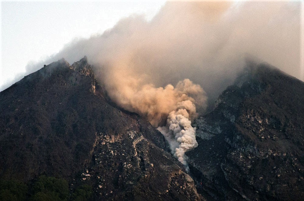
Guatemala , Fuego :
SPECIAL BULLETIN Volcanological BEFGO No. 2-2019, ASH FALLS. Guatemala 31 January 2019, 17:45 (local time).
In recent days, the direction of the wind in the country has changed, which has changed the visual and sound activity in the region of Fuego Volcano. The OVFGO observatory is currently reporting explosions ranging from 13 to 18 per hour, classified as low / moderate explosions, generating ash columns up to about 4,800 meters and dispersing in the wind at distances of 45 km to the East and Northeast, affecting the communities of Alotenango, Antigua Guatemala, Ciudad Vieja. Currently, ash falls are reported in Guatemala City, with the likelihood that they will extend in the same direction and further into the next few hours due to the acceleration of the wind.
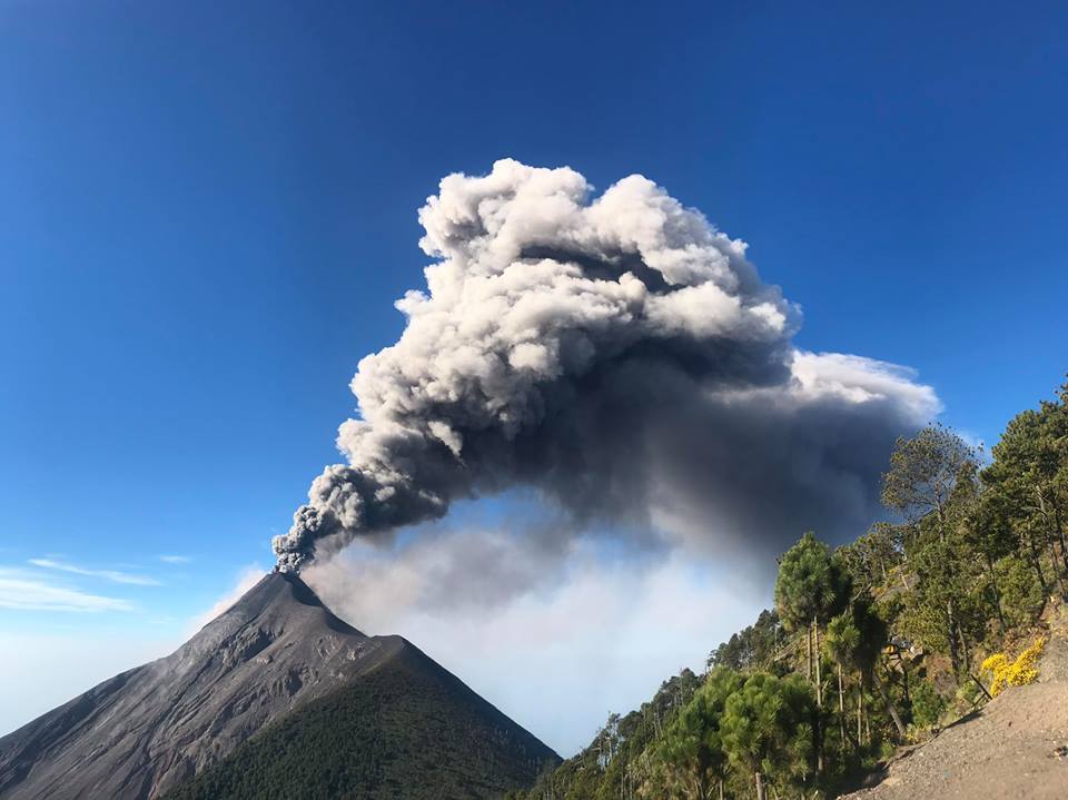
The explosions generate degassing sounds and shock waves that cause vibrations in homes near the volcano. Avalanches can be observed to the Barrancas Seca, Taniluya, Ceniza, Trinidad and Las Lajas with materials down to the edge of the vegetation.
For the above, INSIVUMEH recommends: In SE-CONRED: Continue to take into account the daily activity of the volcano.
To CIVIL AVIATION DIRECTORATE: To be taken into account in the air traffic, ashes lying between 4500 and 4800 meters of altitude dispersing over a distance of approximately 10 to 45 km to the East and North East, affecting Guatemala City, so it is recommended to activate the protocol on ashes.
Source : Insivumeh.
Photo : Jessica Chicco