March 24 , 2021 .
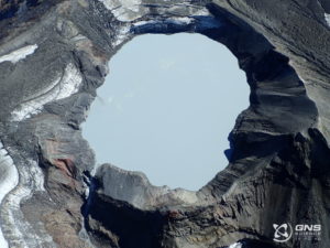
Iceland , Fagradalsfjall :
A minor eruption underway , Uptdated 23.3 at 12:38
Decreasing SW wind today and unhealthy air quality can be expected near the eruption site after 19:00 today. SO2 concentration close to the volcano can surpass over 9000 µg/m3, and CO2 can also gather in valleys in the landscape. It is advised to leave the area before 17:00, keeping away from valleys and following the marked path.
About 8500 earthquakes were measured int he past week with the SIL automatic detection system, a lot less than the previous week when over 19.000 earthquakes were measured. Majority of the measured earthquakes were at the Reykjanes Peninsula where a powerful earthquake swarm has been ongoing since the 24th of February and just by Reykjanestá. One earthquake over M4.0 was measured during the week, on the 15th of March at 22:31 about 2 km ENE of Fagradalsfjall. About 20 earthquakes over M3.0 occurred during the week, most of them located in and around Fagradalsfjall and just out side of Reykjanestá.
Source : Vedur Is.
Photo : Un italiano in Islanda
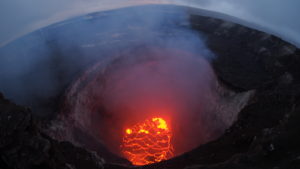
Italy / Sicily , Etna :
Weekly bulletin, from March 15, 2021 to March 21, 2021 (issue date March 23, 2021)
SUMMARY OF THE STATE OF ACTIVITY
In the light of surveillance data, it is highlighted:
1) VOLCANOLOGICAL OBSERVATIONS: Three paroxysmal episodes at the Southeast crater, separated by intervals of relative calm; intracrater explosive activity and degassing of other summit craters.
2) SEISMOLOGY: Increased occurrence rate of fracturing earthquakes. Large and sharp variations in the amplitude of the tremor were correlated with paroxysmal episodes.
3) INFRASON: moderate infrasound activity.
4) DEFORMATIONS: The slowing phase of the deflationary tendency of the volcanic building continues, which began with the sequence of the episodes of the lava fountain.
5) GEOCHEMISTRY: The flow of HCl occurs at an average level.
The flow of SO2 at an average level.
Soil CO2 flux values are based on a low degassing regime.
The partial pressure of dissolved CO2 does not show significant changes.
No update is available for the C / S report.
There are no updated values of the helium isotope ratio (last update 03/11/2021).
6) SATELLITE OBSERVATIONS: The thermal activity in the summit area is at a high level.
VOLCANOLOGICAL OBSERVATIONS
During the week, the monitoring of the volcanic activity of Etna was carried out by analyzing the images of the surveillance cameras of the INGV, Etneo Observatory (INGV-OE)). Due to adverse weather conditions, which affected most of the week, the observation of volcanic activity by cameras was severely limited and discontinuous.
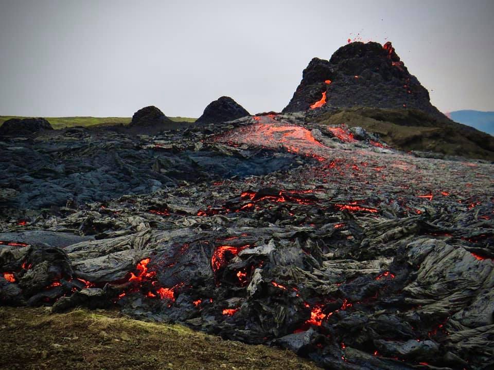
During the week, there were 3 episodes of lava fountains carried by the Southeast Crater, respectively on March 15, 17 and 19. As described in the previous bulletin, the evolutionary phenomenology of eruptive events is common to all fountain events observed so far, and consists of the resumption of Strombolian activity at the Southeast Crater, followed by a gradual intensification up to ‘at the lava fountain. This phenomenon has often been accompanied by one or more flows fed by the same crater.
Fountain of March 15, 2021
On March 14, from 8:10 p.m. UTC, a resumption of Strombolian activity was observed at the Southeast Crater which at 11:48 p.m. UTC, after about 3 hours and 30 minutes, evolved into a lava fountain activity with a dispersion of the eruption cloud in the easterly direction. Thanks to partial visibility, a lava flow was observed which extended along the Valle del Bove. After approximately 3 hours (02:43 UTC), the fountain activity changed to low Strombolian activity while the flow was still active.
Fountain of March 17, 2021
As of 00:55 UTC, an increase in Strombolian activity began at the Southeast Crater which, in about 1 hour and 30 minutes (02:19 UTC), transformed into a lava fountain with a scattering of the eruptive cloud towards the South-East. Even during this phenomenon, due to cloud cover, observations were limited and discontinuous. In a few brief moments of visibility, it was possible to observe the formation of a flow overlapping that observed on March 15.
At 06:17 UTC, after about 4 hours, fountain activity was over and modest explosive activity was observed. At 17:59 UTC, it was possible to observe that the lava flow along the Valle del Bove had reached an altitude of about 2200 m above sea level.
On 18 at 20:41 UTC, after partial visibility of the summit area, it was observed that the lava flow along the wall of the Valle del Bove and the explosive activity at the Southeast Crater was continuing.
March 19, 2021 fountain
At 6:34 a.m. UTC, explosive activity continued to be observed in the Southeast Crater and from 8:15 a.m. UTC this activity began to intensify with obvious ash emission. At 08:35 UTC, lava fountain activity was observed and the forecast for the eruptive cloud dispersion was in an east-northeast direction. At 10:36 UTC, after about 2 hours, the fountain was complete, giving way to Strombolian activity which gradually decreased until 12:50 UTC, sporadic explosive activity with low ash emission was observed.
At the end of the morning, thanks to partial and limited visibility of the summit area, a flow was observed along the Valle del Bove.
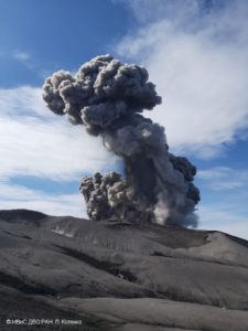
New climax …..
Press release on ETNA’s activity, 23 March 2021, 20:51 (19:51 UTC):
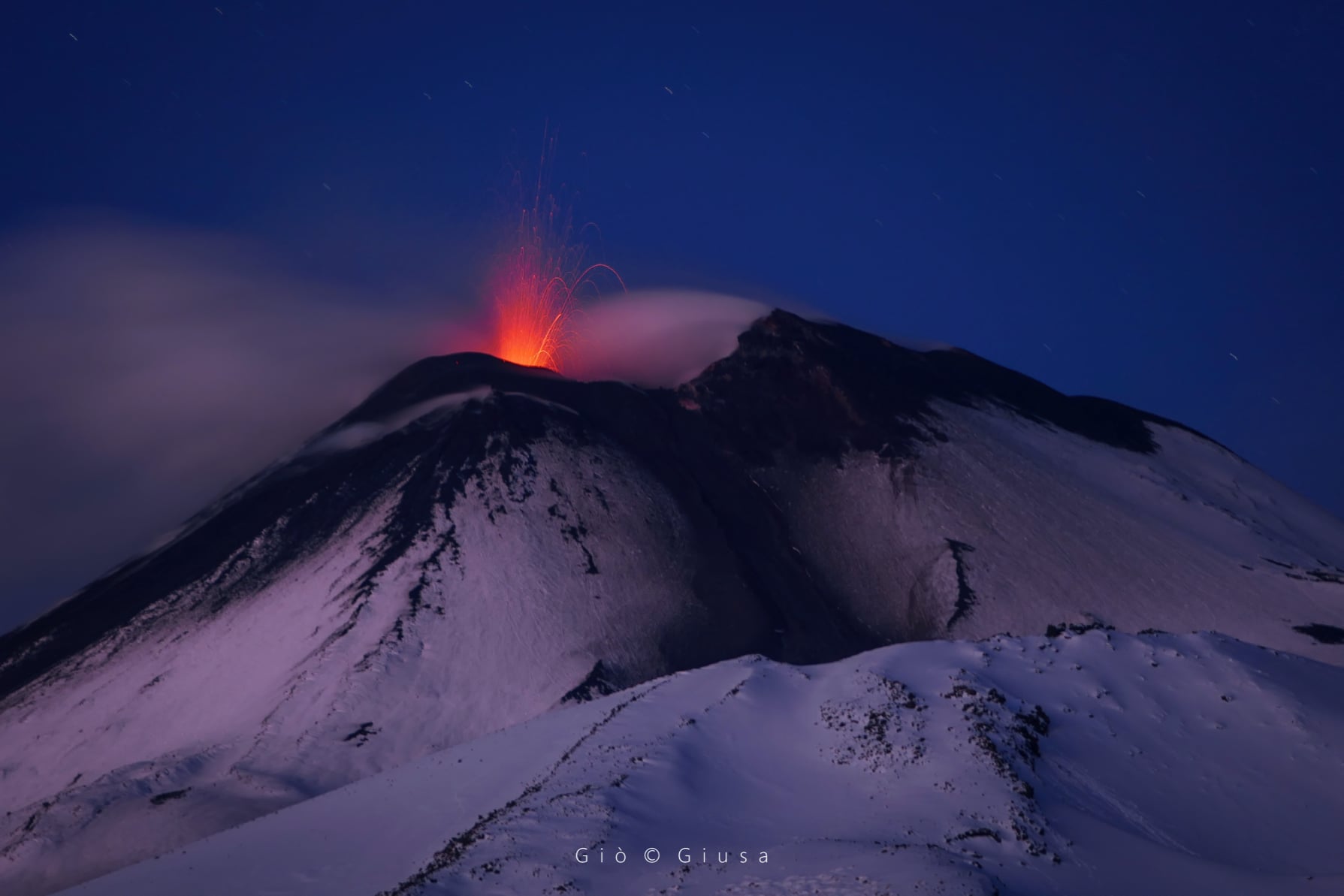
The National Institute of Geophysics and Volcanology, Osservatorio Etneo, announces that from 19:05 GMT we observe the resumption of a weak Strombolian activity at the Southeast Crater.
At present, the time trend of the average amplitude of the tremor remains in the range of average values. Infrasound activity over the last hour shows a slight increase in the number of events. Ground deformation signals from GNSS and tilt monitoring networks do not show significant changes.
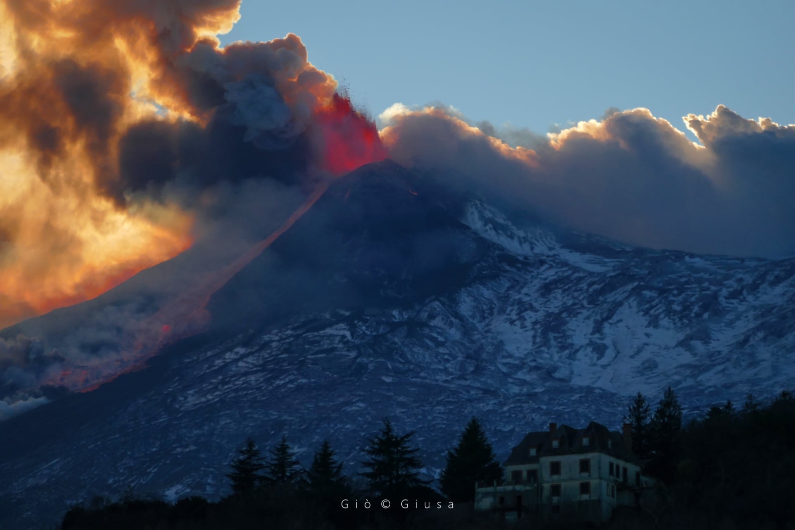
23:16 (22:16 UTC): A lava fountain is underway at the Southeast Crater. Based on the forecast model, the eruptive cloud produced by the current activity disperses in a South-South-West direction.
The average amplitude of the volcanic tremor shows high values with an increasing trend. Infrasound activity is also supported both in the rate of occurrence and in the energy of events. There are small oscillations in the radial component of the ECP (Crater del Piano) tilt measurement summit station, there are no significant changes at other stations in the tilt and GNSS measurement networks.
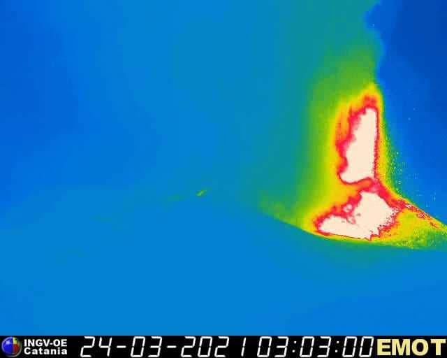
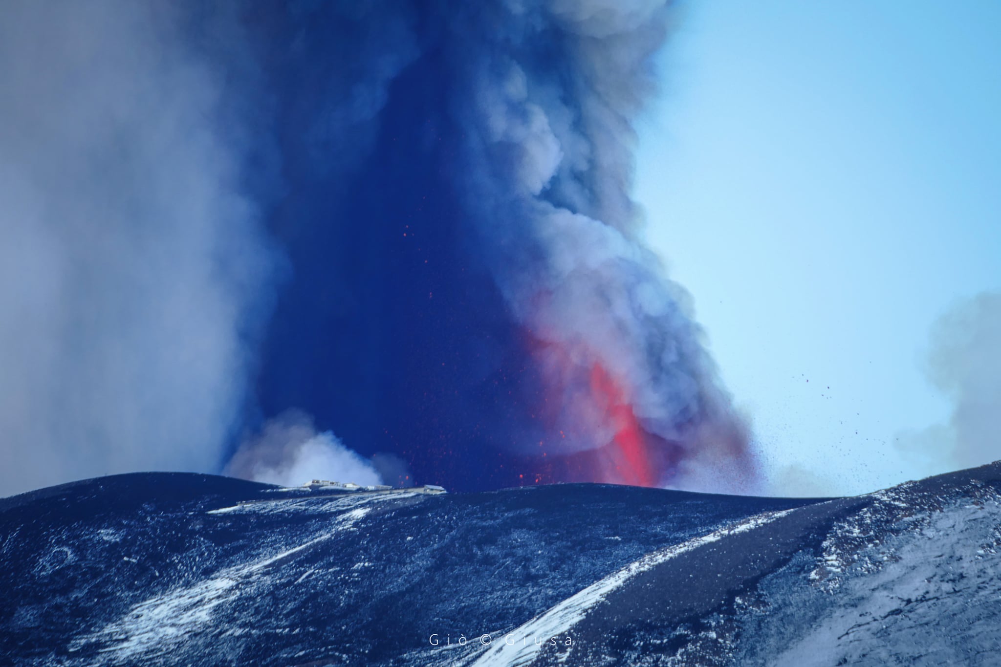
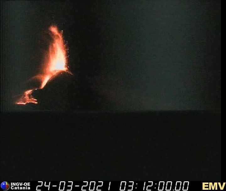
March 24, 2021, 04:01 (03:01 UTC); From around 22:00 GMT an intensification of the activity of the lava fountain is observed. Based on the forecast model, the eruptive cloud produced by the current activity disperses in a South-South-West direction, in accordance with direct observations by INGV-OE staff. At 02:37 GMT, a pyroclastic flow was also observed from the INGV-OE video surveillance cameras, also confirmed by the INGV staff present on site. The flow heads towards the Valle del Bove reaching a height of about 2900 m.
From the seismic point of view, the increase in the amplitude of the volcanic tremor continues at very high values. Infrasound activity is also supported both in the rate of occurrence and in the energy of events.
Little distortion is observable at the top tilt stations, while signals from GNSS stations show no significant variation over the past few hours.

The maximum height estimated from satellite data is 6000 m above sea level. In addition, INGV-OE staff reported an ash fall in Catania.
07:13 (06:13 UTC): there are two flows, one well fed towards the Valle del Bove which reached an altitude between 1900 and 1800 m, and another less fed towards the South which reaches the area Summit.
Source : INGV.
Photos : Gio Giusa , INGV , Boris Behncke .
Philippines , Taal :
TAAL VOLCANO ADVISORY 24 March 2021 12:30 PM.
This is a notice of elevated increase in seismic activity at Taal Volcano.
Since ongoing unrest began on 13 February 2021, a total of two thousand fifteen (2,015) volcanic tremors, seven hundred thirty-four (734) low-frequency volcanic earthquakes and eighteen (18) hybrid earthquake events have been recorded by the Taal Volcano Network. Harmonic tremor associated with magma migration has become the dominant type of earthquake since 19 March 2021. Most earthquake events occurred at shallow depths of <2 kilometers although some large earthquakes were generated in the deeper 2-6 kilometers region beneath the Taal Volcano Island (TVI) edifice.
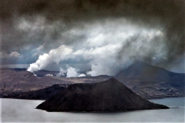
Overall seismic energy release has markedly increased since yesterday afternoon compared to previous seismic swarms. Sulfur dioxide gas emission in the previous week has been generally high with a peak of 1,184 tonnes/day on 21 March 2021. Ground deformation of TVI and the Taal Caldera region in general has remained steady and at slight inflationary trends since February 2021. The above parameters indicate that magma has been migrating across shallow depths beneath TVI, increasing the possibilities of magmatic eruption.
Source : Phivolcs
Photo : EDWIN BACASMAS.
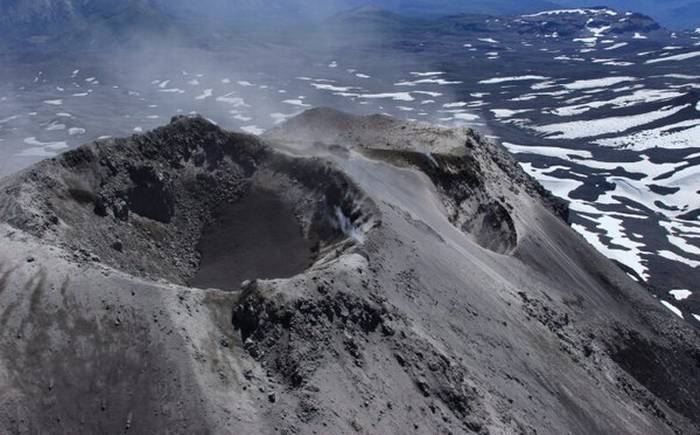
Chile , Nevados of Chillan :
Special Report on Volcanic Activity (REAV), Ñuble region, Nevados de Chillán volcanic complex, March 22, 2021, 11:40 a.m. local time (Continental Chile).
The National Service of Geology and Mines of Chile (Sernageomin) publishes the following PRELIMINARY information, obtained thanks to the monitoring equipment of the National Volcanic Monitoring Network (RNVV), processed and analyzed in the Volcanological Observatory of the Southern Andes ( Ovdas):
On Monday, March 22, at 11:16 a.m. local time (2:16 p.m. UTC), the monitoring stations installed near the Nevados de Chillán volcanic complex recorded an earthquake linked to the fracturing of the rock (Volcano-Tectonic), located at 4 km south-east of the active emissions center.
The characteristics of the earthquake after its analysis are as follows:
TIME OF ORIGIN: 11:16 local time (14:16 UTC).
LATITUDE: 36.884 ° S
LONGITUDE: 71.338 ° W
DEPTH: 4.0 km
LOCAL MAGNITUDE: 3.3 (ML)
OBSERVATIONS:
No surface activity associated with this seismic event was observed.
The volcanic technical alert remains at the Yellow level.
Source : Sernageomin .
Photo : Radio universidad de chile.
Guatemala , Pacaya :
SPECIAL VOLCANOLOGICAL BULLETIN, 23 March 2021, 16:02 local time
UPDATE ON ACTIVITY AND ASH FALLS
In the last few hours, the Pacaya volcano exhibited short-lived pulses that favored the formation of columns of gas and ash 4000 meters above sea level (13,123 feet), however, given the variability of the wind at different heights, these were scattered in both North-West, North, North-East and East directions.
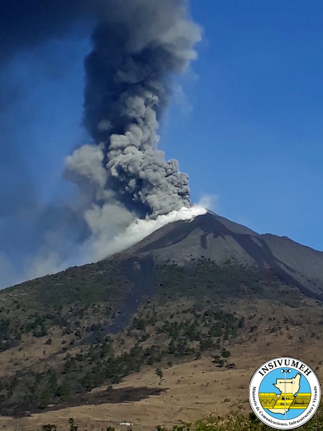
Simultaneously, OVPAC observers report airplane turbine-like sounds and moderate to strong ballistic projections ejected 500 meters above Mackenney crater. Effusive-type activity allowed the southwestward lava flow to continue to be active, with reported lengths of up to 3000 meters, with the likelihood of reaching vegetation in the next few hours. The instrumental parameters place the activity of the Pacaya volcano at high levels and with a tendency to remain so in the coming days.
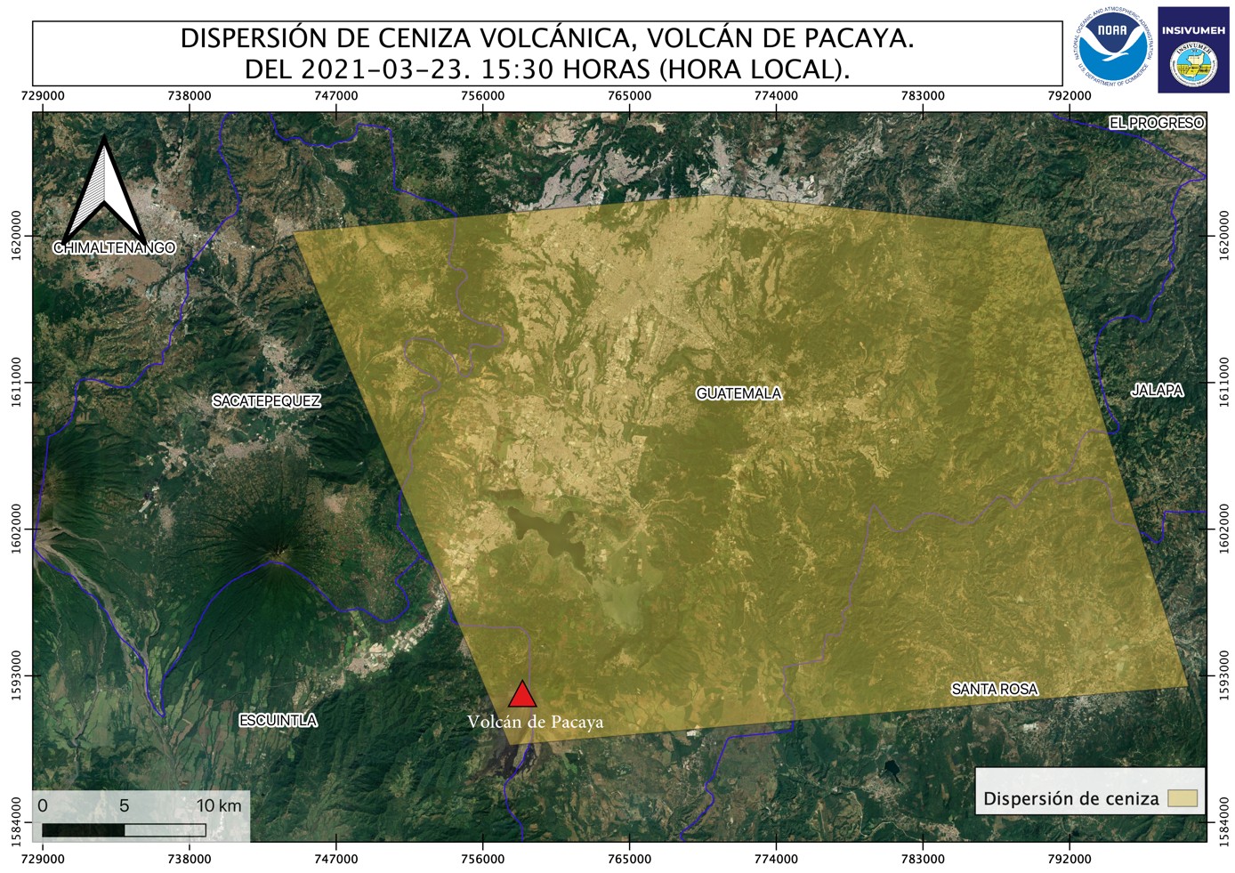
Figure n ° 1: Ash dispersion map for the Pacaya volcano. Departments concerned: Guatemala, Sacatepequez, Santa Rosa.
It is not excluded that volcanic activity generates more energetic activity impulses in the coming hours or days, which increase the height and density of the eruptive column. According to meteorological models, the wind direction should remain towards the southwest, so it is not excluded that the ash fall will continue to affect the municipalities of the department of Guatemala and the capital.
Therefore, it is necessary to maintain the closure of La Aurora International Airport.
Source : INSIVUMEH .
Photos : Insivumeh