March 20 , 2021 .
Iceland , Reykjanes Peninsula :
SPECIAL ERUPTION…
A volcanic eruption has begun
Updated 19.03 23:20
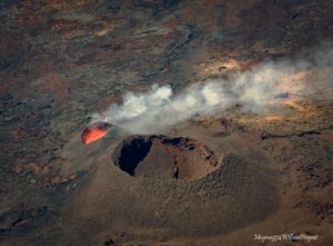
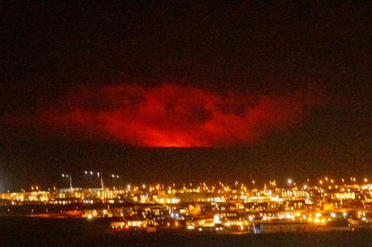
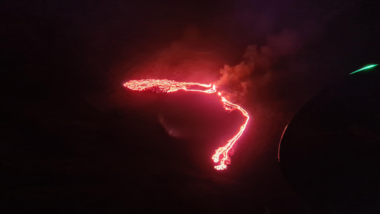
At around 20:45 UTC today, 19 March, a volcanic eruption began at Geldingadalur, close to Fagradalsfjall on the Reykjanes Peninsula. The eruption was first seen on a web camera positioned close the mountain. It was also confirmed on thermal satellite imagery. At the time of writing, the weather on the peninsula is wet and windy, and an orange glow can be seen in low clouds on the horizon from Reykjanesbær and Grindavík.
The eruption site is in a valley, about 4.7 km inland from the southern coast of the peninsula. The coastal town of Grindavík is the closed populated region to the eruption site, located approximately 10 km to the southwest.
Earthquake activity in the region of the magma intrusion has been lower in recent days, and there is presently no intense seismicity occurring in the region. Earlier in the day, several low-frequency earthquakes were recorded below Fagradalsfjall. There are presently no reports of ash fall, although tephra and gas emissions are to be expected.
In line with well-rehearsed contingency plans, the aviation colour code for the Reykjanes Peninsula has been elevated to red, signifying an eruption in progress. Additional domestic restrictions have been put in place, including the closure of Reykjanesbraut – the main road from the capital region to Reykjanesbær and the international airport at Keflavík.
This eruption started this evening, March 19th at 20:45 near Fagradalsfjall in Geldingadalur. The eruption is considered small at this stage and the eruptive fissure is app. 500 – 1000 m long. The magma area is app. 1km2. Lava fountains are small. Next flight will be at 07:00 hrs.
Source : Vedur Is.
Photo : vf.is , Vedur .
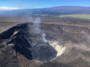
Italy / Sicily , Etna :
Communication on ETNA activity, March 19, 2021, 13:50 (12:50 UTC).
The National Institute of Geophysics and Volcanology, Osservatorio Etneo, reports that Strombolian activity at the Southeast Crater has decreased. Sporadic explosions and low ash emissions are observed. The forecast model indicates the dispersion of the eruptive cloud in the east-northeast direction.
Due to the cloud cover, observation of the activity is very limited.
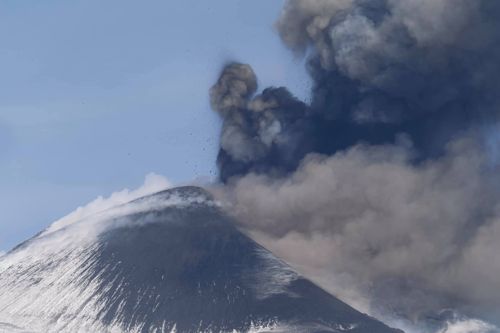
The amplitude of the tremor decreased to average levels. Infrasound activity also decreased but more. The sources of the tremor are located under the Southeast Crater at an altitude of 2500 m from the end of the paroxysmal phase. In particular, the inclinometric signals tend to drop towards the pre-lava fountain values.
Further updates will be communicated shortly.
Source : INGV.
Photo : Marco Kaschuba
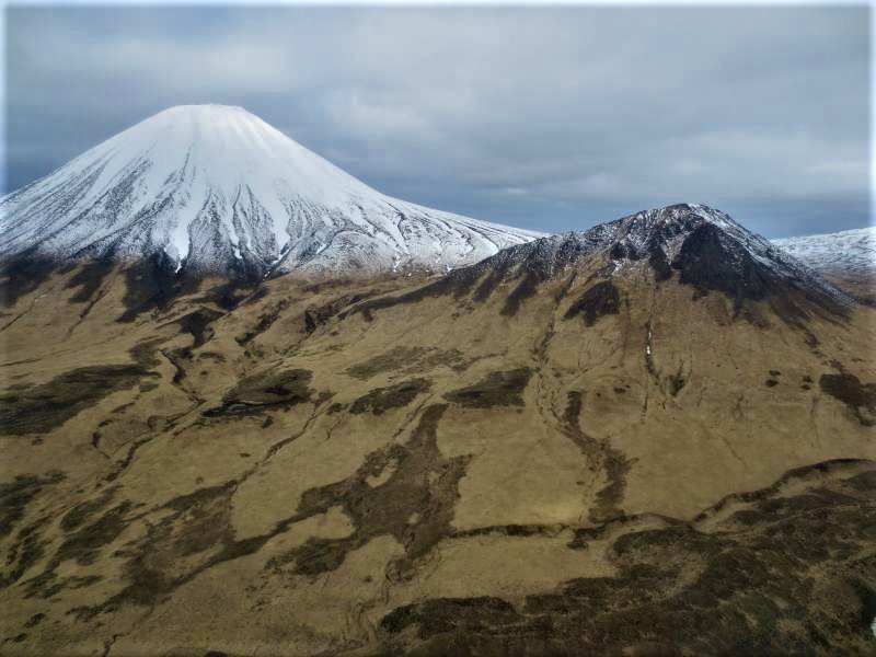
Indonesia , Merapi :
Mount Merapi Activity Report, March 12-18, 2021
OBSERVATION RESULTS
Visual
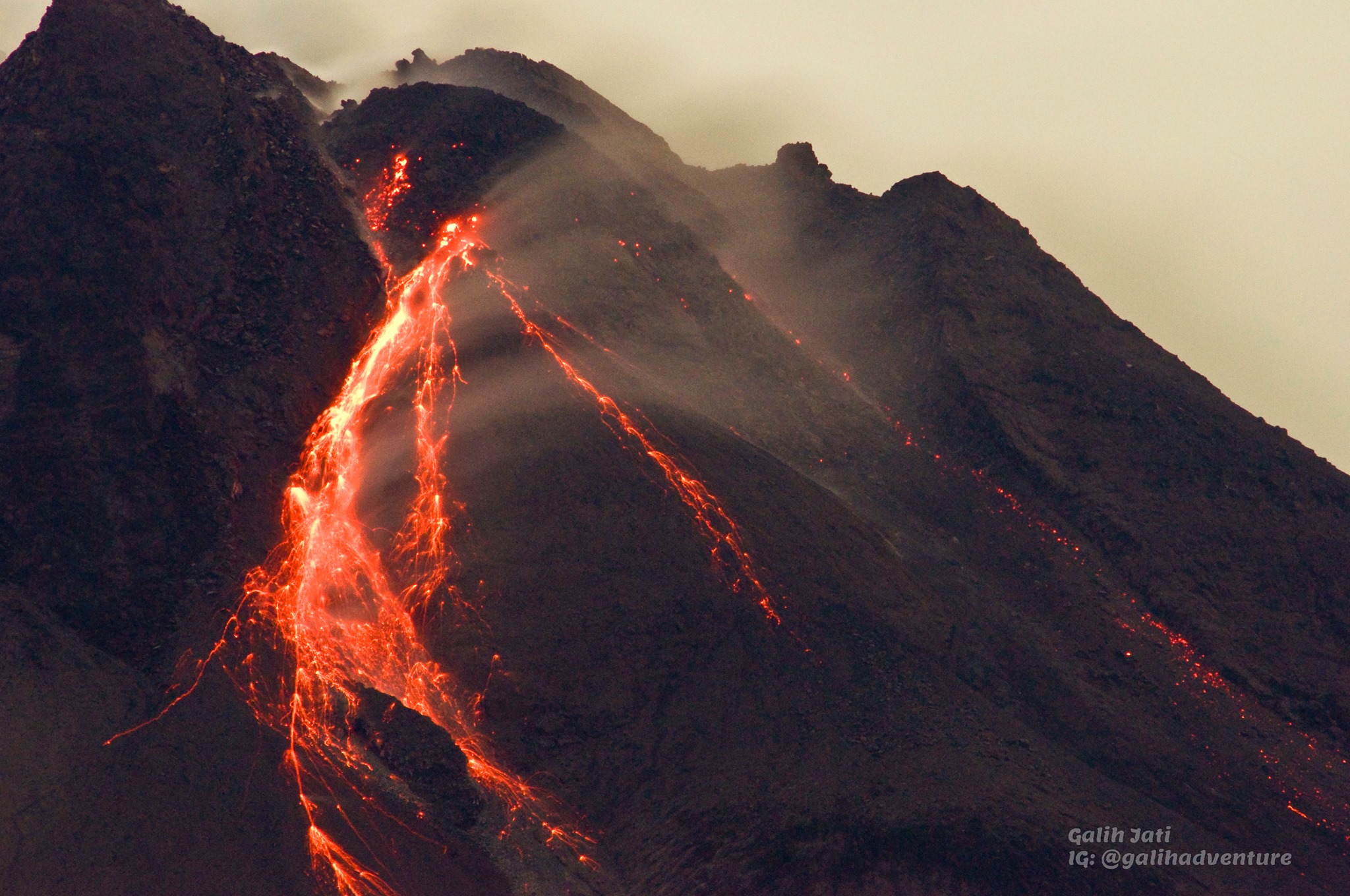
The weather around Mount Merapi is generally sunny in the morning and evening, while the afternoon until evening is foggy. There is white smoke, thin to thick with low pressure. A maximum smoke height of 800m was observed from the Mount Merapi de Selo observation post on March 18, 2021 at 2:15 p.m. WIB.
Hot avalanche clouds occurred 3 times with a maximum slide distance of 1000 m to the southwest and were recorded on a seismogram with a maximum amplitude of 40 mm and a duration of 102 seconds on March 12, 2021 at 7:00 a.m. WIB. Lava avalanches were observed 211 times with a maximum sliding distance estimated at 1,200 meters to the southwest and 4 times in the crater.
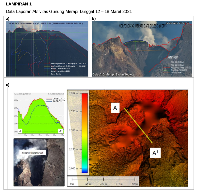
Morphological analysis of the peak area based on photos from the southwest sector dated March 11 to March 18, 2021 showed changes in the morphology of the peak area due to shedding activity and dome growth. The volume of the lava dome in the southwest sector is 840,000 m3 with a growth rate of 12,900 m3 / day. Morphological analysis of the South-East sector shows that the height of the central dome is 65 m, and the estimated volume of the dome is 950,000 m3 with a growth rate since January 4, 2021 of 12,800 m3 / day.
Seismicity
This week, the seismicity of Mount Merapi recorded
3 hot cloud avalanches (AP),
2 shallow volcanic earthquakes (VTB),
33 multi-phase earthquakes (MP),
1 low frequency earthquake (LF),
1059 avalanche earthquakes (RF),
64 emission earthquakes (DG)
15 tectonic earthquakes (TT).
Seismic activity this week is still dominated by surface earthquakes such as RF, DG and AP.
Deformation
The deformation of Mount Merapi which was monitored using EDM and GPS this week showed no significant changes.
Rain and lahars
This week there was rain at the Mount Merapi observation post with the highest rainfall intensity of 83mm / hour for 75 minutes at Kaliurang post on March 15, 2021. There was a lahar flow. low intensity on March 12 and 17, 2021 in the Boyong River.
Conclusion
Based on the results of visual and instrumental observations, it is concluded that:
The volcanic activity of Mount Merapi is still quite high in the form of effusive eruption activity. The activity status is defined at the « SIAGA » level.
Source : BPPTKG
Photo : Yohannes Tyas Galih Jati.
Guatemala , Pacaya :
SPECIAL VOLCANOLOGY BULLETIN, March 18, 2021 at 11:41 a.m. local time.
UPDATE ERUPTIVE ACTIVITY
As has been reported in special bulletins, the Pacaya volcano continues with periods of increased magmatic activity. In the Mackenney crater, they manifest themselves with explosions accompanied by thick columns of ash, at heights of 3,000 to 3,500 meters above sea level. (9,842 to 11,482 feet) dispersing to the south, southwest, for a distance of about 25 to 30 kilometers. Rumblings and sounds of locomotives, as well as falling ash, are reported in the villages of El Rodeo, Patrocinio, Los Pocitos and others in these directions. We also observe the expulsion of ballistic projections 300 meters above the crater, they fall at a distance of 400 meters.
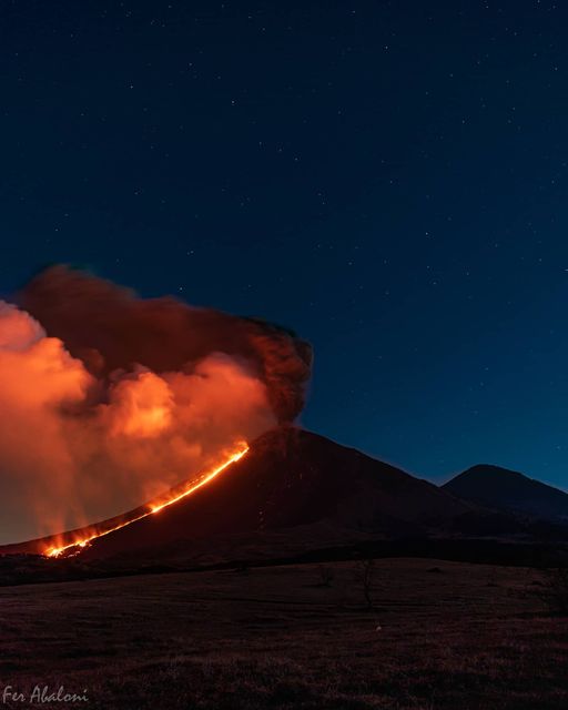
On the southern flank, the lava flow is maintained over a length of 500 meters. Due to the high activity, 2 new lava flows were generated, one towards the South with 500 meters in length, part of this flow overflows outside the plateau. The second new stream is located in the east, opposite the village of Los Llanos, with a length of 400 meters. In its movement, it causes fires in the vegetation. According to reports from OVPAC observers, CONRED web cameras, GOES-16 satellite imagery, activity in the crater maintains periods of high intensity, generates aircraft turbine sounds and low and moderate rumblings, audible in villages near the volcano. The recording of the seismic stations of PCG, and PCG5, shows the increment pulses in the last hours, which favors the formation of thick columns of ash.
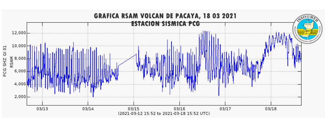
GRAPHIC RSAM STATION PCG
Taking into account the behavioral model that the Pacaya volcano has shown in recent weeks, it is considered that the activity continues at high levels and it is not excluded that the activity pulses will continue to increase in the coming hours, generating explosions, ballistic projections, ash falls, and / or the appearance of new lava flows or the increase in their length.
Source : Insivumeh .
Photo : Fernando Abaloni via Sherine France .
Alaska , Semisopochnoi :
51°55’44 » N 179°35’52 » E,
Summit Elevation 2625 ft (800 m)
Current Volcano Alert Level: WATCH
Current Aviation Color Code: ORANGE
Two small explosions from Seimisopochnoi were detected in regional infrasound data at 11:50 UTC (03:50 AKDT) and 13:34 UTC (05:34 AKDT) this morning prompting the AVO to raise the Aviation Color code from Yellow to ORANGE and the Volcano Alert Level from Advisory to WATCH. Cloudy weather conditions are obscuring satellite views of the volcano and it remains unknown if the explosions produced low-level ash clouds or local ash deposits. A possible volcanic gas cloud was observed in satellite data from Thursday and retrospective analysis identified a minor ash deposit on the flank of Semisopochnoi on March 14.
Small eruptions producing minor ash deposits within the vicinity of the volcano are typical of activity during unrest at Semisopochnoi since September 2018. Local seismic stations have been offline since November 11, 2020. New explosions could occur at any time with no warning.
Semisopochnoi is monitored remotely by satellite and lightning sensors. An infrasound array on Adak Island could detect explosive emissions from Semisopochnoi with a 13 minute delay if atmospheric conditions permit.
Source : AVO
Photo : Kaufman, Max