September 26 , 2022.
La Réunion , Piton de la Fournaise :
Press release, Paris Institute of Earth Physics, Piton de la Fournaise Volcanological Observatory, September 25, 2022 – 11:00 a.m. (local time) – 7:00 a.m. (UTC time).
Ongoing eruption
The eruption started on 09/19/2022 around 07:48 local time continues. The amplitude of the eruptive tremor (indicator of surface lava emission) has remained generally stable over the past 24 hours, at around 20% of its initial amplitude (Figure 1).
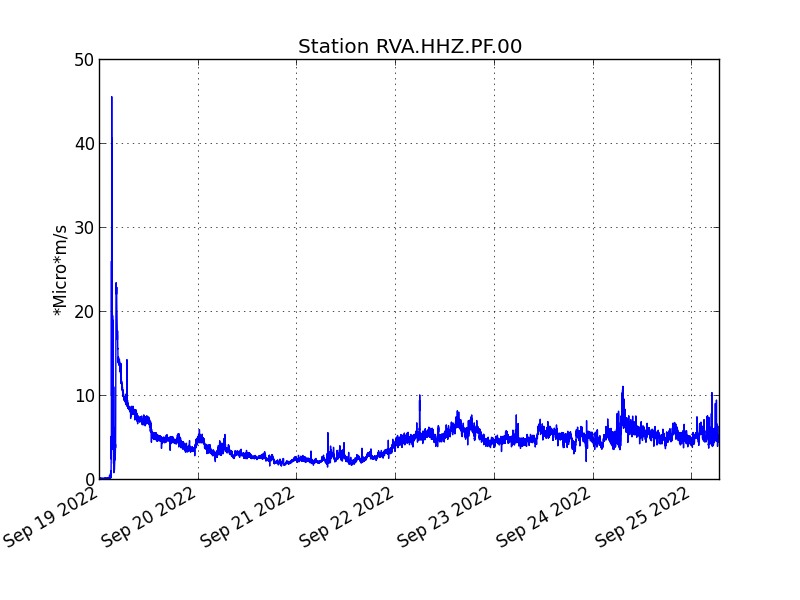
Evolution of the RSAM (indicator of a surface lava emission) since 09/19/2022 00:00 UTC time (04:00 local time) on the RVA seismological station located at the Rivals crater (© OVPF / IPGP).
– No volcano-tectonic earthquake has been recorded directly above the summit area over the past 24 hours.
– Over the last 72 hours, no significant deformation has been recorded.
The lava flow estimates established by satellite method on the HOTVOLC (OPGC – Clermont Auvergne University) and MIROVA (University of Turin) platforms indicate an average flow over the last 24 hours relatively stable and low between 1 and 3 m3 / s.
The acquisitions of the COPERNICUS program developed by the European Commission provide images of the TROPOMI instrument intended for the observation of the composition of the atmosphere, and in particular the concentrations of SO2. September 24 images indicated a weak gas plume still trending west-southwest. The mass of SO2 visible in the image was less than 0.5 kton.
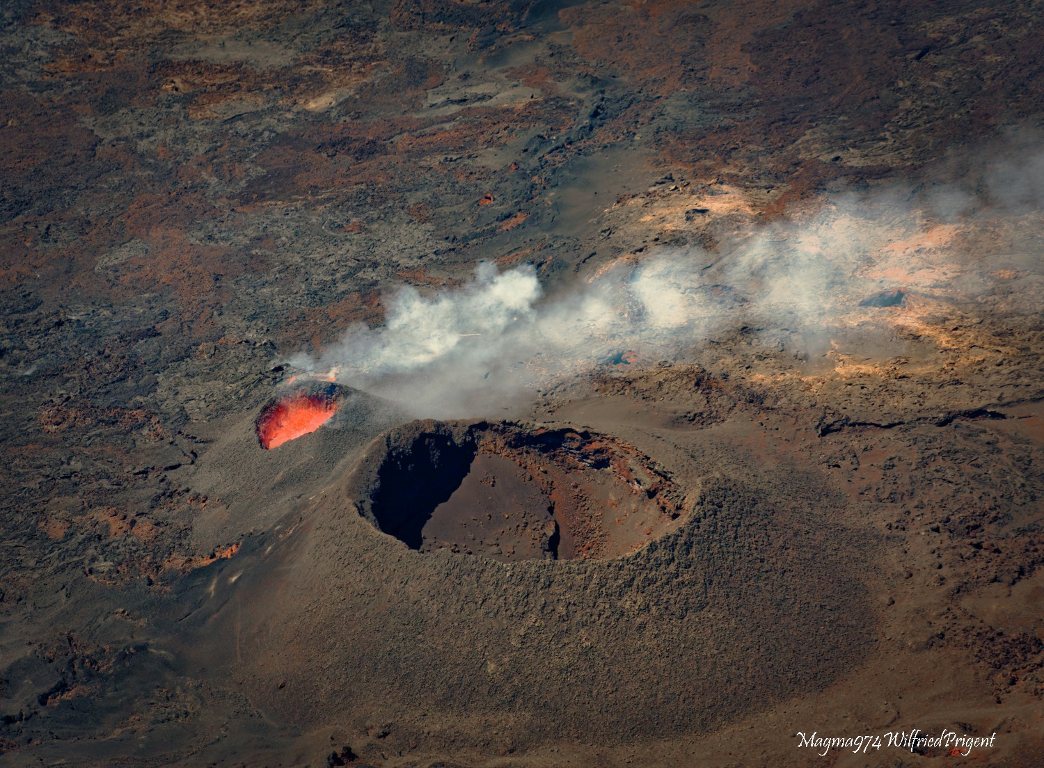
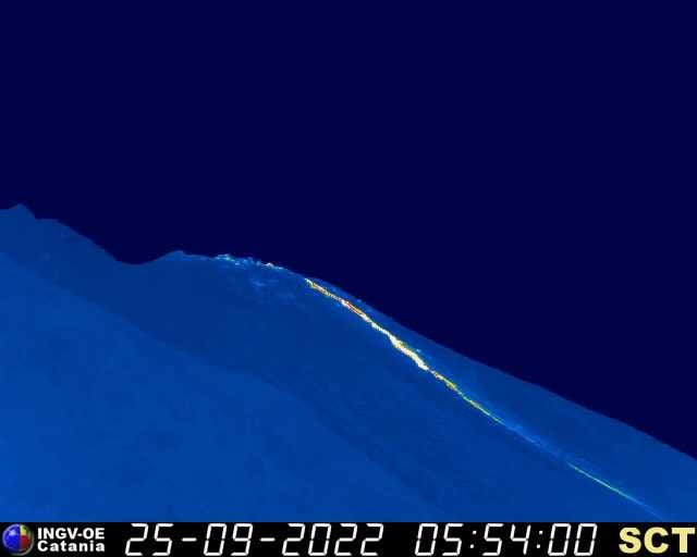
The images from the OVPF-IPGP webcam located at Piton de Bert show this morning 09/25/2022:
– still significant degassing at the eruptive site and low amplitude lava projections;
– a gas plume still directed West South-West as also observed on satellite data;
– a lava flow activity still mainly through lava tunnels as observed yesterday by infrared imagery (Figure 3 and 4);
– several resurgences of lava visible at the level of the tunnels.
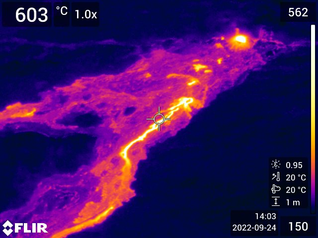
Shooting in infrared imagery of the eruptive site on September 24, 2022 around 11 a.m. local time (©OVPF-IPGP).
Alert level: Alert 2-1 (eruption in the Enclos without any particular threat to the safety of people, property or the environment)
Source : Direction OVPF / IPGP.
Photos : OVPF , Magma 974 / Wilfried Prigent.
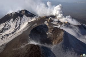
Italy , Stromboli :
Press release on the activity of STROMBOLI, September 25, 2022, 16:47 (14:47 UTC).
The National Institute of Geophysics and Volcanology, Osservatorio Etneo, announces that monitoring networks recorded the return of parameters to normal activity at 4:44 p.m. (2:44 p.m. UTC).
Further updates will be communicated soon.
Source : INGV.
Philippines , Pinatubo / Taal :
LAHAR ADVISORY FOR PINATUBO AND TAAL VOLCANOES 25 September 2022 07:00 PM
Based on the Tropical Cyclone Bulletin 18 issued at 05:00 PM today by the Philippine Atmospheric Geophysical and Astronomical Services Administration (PAGASA), Supertyphoon “KARDING” is expected to bring heavy to intense with at times torrential rains this evening through tomorrow early morning over Metro Manila and portions of CALABARZON and Central Luzon. These rains could generate volcanic sediment flows or lahars, muddy streamflows or muddy run-off in rivers and drainage areas on Pinatubo and Taal volcanoes.
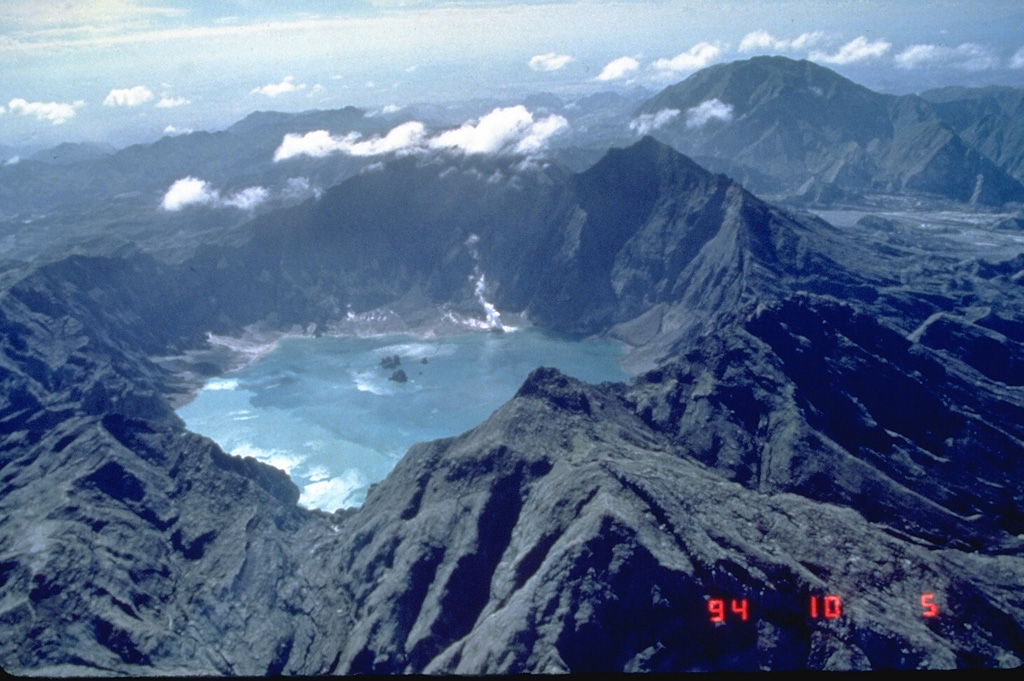
Prolonged and intense rainfall may generate non-eruption lahars on major rivers draining western Pinatubo Volcano where significant deposits of the 1991 PDCs remain on the watershed. Pinatubo lahars are likely be channel-confined and occur on the upper to middle reaches of the Sto. Tomas- Marella and Bucao River systems but may transition to muddy streamflows and floods on the lower reaches and affect adjacent communities of San Marcelino, San Narciso, San Felipe and Botolan, Zambales Province. Muddy streamflows may likewise be generated along the O’Donnell and Pasig-Potrero River systems draining the Pinatubo edifice to the north and southeast, respectively and affect downstream communities in Tarlac and Pampanga Provinces.
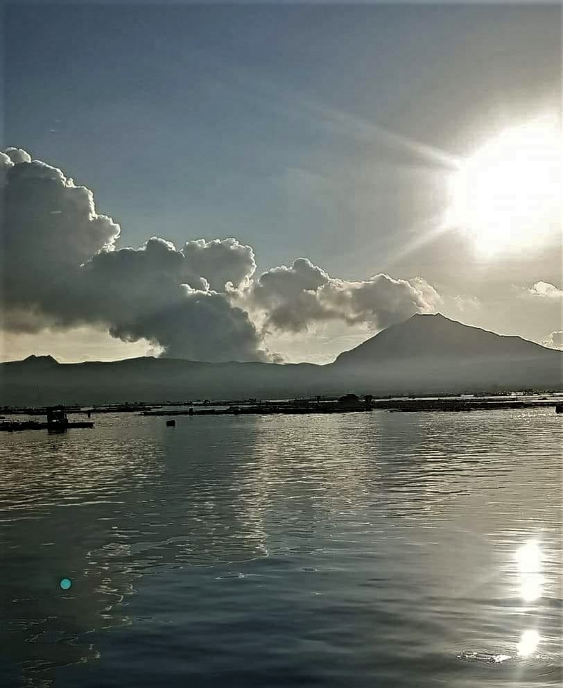
Prolonged and heavy rainfall may also generate muddy streamflow and muddy runoff around Taal Volcano, particularly on the slopes on the western Taal Caldera where thin remnant ash can be remobilized in streams and roads and overland of the lakeward slopes. In particular, muddy streamflow and runoff can recur on previously affected communities of Agoncillo and Laurel, Batangas Province. In addition to this, extensive fissures on the northeast and southwest sectors of Taal Caldera generated by the 2020 eruption may be eroded and enlarged by heavy rains, as was the case in previous typhoons when even previously undetected fissures emerged and caused damages to overlying or adjoining buildings and houses.
Source : Phivolcs
Photos : GVP / Ray Punungbayan, 1994 (Philippine Institute of Volcanology and Seismology), Onin casal /Agoncillo ERT.
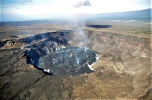
Hawaii , Kilauea :
19°25’16 » N 155°17’13 » W,
Summit Elevation 4091 ft (1247 m)
Current Volcano Alert Level: WATCH
Current Aviation Color Code: ORANGE
Activity Summary:
The summit eruption of Kīlauea Volcano, within Halemaʻumaʻu crater, continued over the past 24 hours. All recent eruptive activity has been confined to the crater. No significant changes have been observed at the summit or in either rift zone.
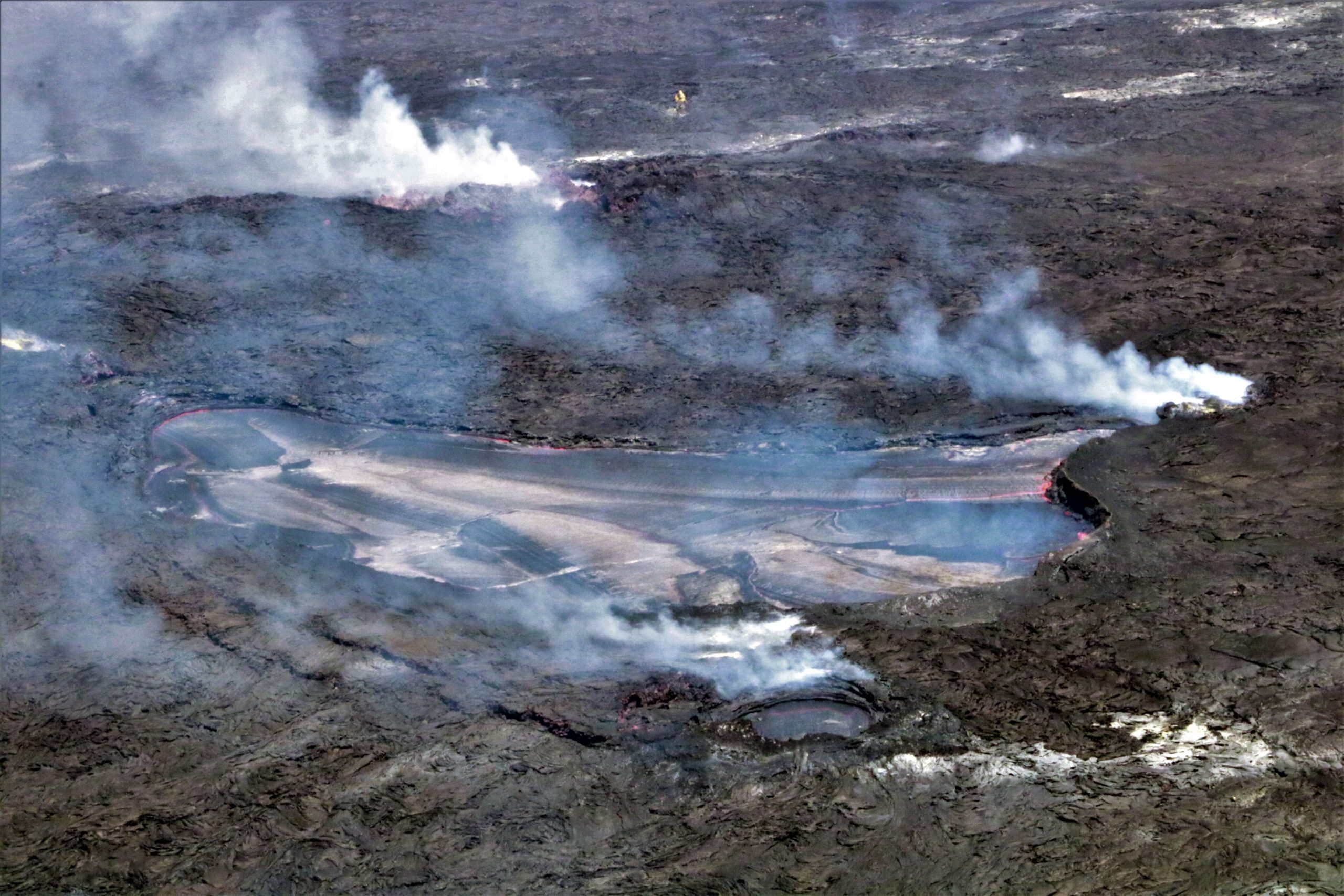
Halemaʻumaʻu Lava Lake Observations:
Eruption of lava from the western vent into the active lava lake and onto the crater floor continued over the past 24 hours with minor breakouts continuing from the western part of the crater floor. The active part of the lava lake has stated steady over the past 24 hours. Overflight measurements from September 12, 2022, indicated that the crater floor had seen a total rise of about 143 meters (469 feet), since the beginning of this eruption on September 29, 2021.
Summit Observations:
Summit tiltmeters have shown a minor deflationary-inflationary (DI) event over the past 24 hours. Volcanic tremor remains above background levels. A sulfur dioxide (SO2) emission rate of approximately 930 tonnes per day (t/d) was measured on September 21, 2022.
Rift Zone Observations:
No unusual activity has been noted along the East Rift Zone or Southwest Rift Zone; low rates of ground deformation and seismicity continue along both. Measurements from continuous gas monitoring stations downwind of Puʻuʻōʻō in the middle East Rift Zone remain below detection limits for SO2, indicating that SO2 emissions from Puʻuʻōʻō are negligible.
Source : HVO.
Photo : USGS / K. Mulliken
Guatemala , Santiaguito :
Activity:
The Santa María-Santiaguito Volcanic Complex Observatory reports abundant degassing fumaroles 600 meters above the Caliente dome, which is moving southwest, as well as abundant steam from the active lava flow . This vapor is moving eastward at a lower level of elevation. Incandescences were observed in the dome, avalanches descending on the western flank, as well as some explosions which cause the descent of incandescent material on all the flanks of the Caliente dome. Activity ahead of the active lava flow in the San Isidro and El Tambor channels continues with some boulder collapses, which generate ash clouds up to several hundred meters high.

It is recommended not to approach the lava flow, due to the intense heat it emits and the constant collapses that occur on its edges, which could cause burns and other serious injuries to those who come close. The extrusive activity remains at a high level and continues to accumulate materials in an unstable way in the lava flow in the channels of San Isidro and El Tambor, as well as in the cupola of the Caliente dome, so it remains possible that a part of this material collapses generate pyroclastic flows over long distances are generated towards the South-West, South and East.
Source : Insivumeh.
Photo : Annie Winson , earthobservatory.sg