March 12 , 2021 .
Iceland , Reykjanes Peninsula :
A volcanic eruption remains a possibility at Reykjanes Peninsula , Updated 11.03 at 16:00
Over 1700 earthquakes have been measured in the Reykjanes Peninsula since midnight, few of which were over M3, the largest one measured M4,6 at 08:53 GMT this morning. As before, the magmatic activity is centered around Mt. Fagradalsfjall southwest of Mt. Keilir.
Yesterday, March 10th, 2500 earthquakes were detected in the Reykjanes Peninsula, 40 of which were over M3, the largest one measuring M5,1 at 3:14 GMT.

Yesterday, the Scientific Advisory Board of the Icelandic Civil Protection met to discuss the latest monitoring results from the seismic unrest on the Reykjanes Peninsula. The main findings of the meeting were:
The dike intrusion is expanding with the most active magma flow centered at the southern part of it. A volcanic eruption remains a possibility as magma is still flowing into the corridor. With the ongoing activity the probability of an eruption increases day by day. It is considered very unlikely that lava from a possible eruption would reach populated areas.
It is important to follow the activity in the southern region of Mt. Fagradalsfjall in order to evaluate whether the dike is expanding to the south.
Latest satellite images and GPS data show that accumulation of magma is concentrated at the southern end of the dike beneath Mt. Fagradalsfjall. This is currently the most likely site for a possible eruption.
If the dike keeps expanding and increasing stresses in the area, continuing earthquake activity that can be felt in populated areas is expected.
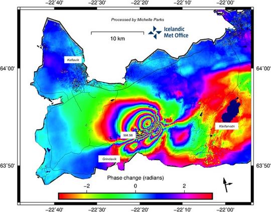
InSAR image reflects changes between March 3 to March 9 2021. Image contains modified Copernicus Sentinel data [2021]
Possible eruption could begin without strong precursory signals
Currently, the magma is shallow, lying 1-1,5 km beneath the crust. Therefore, it can be expected that an eruption could start without a strong precursory signal, as the magma can easily brake through the last hundreds of meters of the crust once the critical pressure is reached. From experience of lava flow eruptions (as we might expect), the eruption tremor is weak and has a low amplitude. For this reason, the IMO has installed webcams which can be used to monitor the area, in case of an eruption will start without clear precursory signals.
Source : Vedur Is .
Italy / Sicily , Etna :
Communication on ETNA’s activity, March 12, 2021, 04:48 (03:48 UTC).
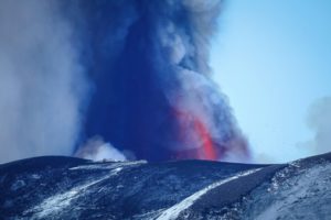
The National Institute of Geophysics and Volcanology, Osservatorio Etneo, reports that modest Strombolian activity is underway in the Southeast Crater, while intracrater explosive activity continues in the craters of the Voragine, the Bocca Nuova and Northeast.
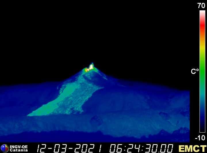
The average amplitude of the volcanic tremor shows an increase reaching high values and the sources of the tremor are located under the Southeast Crater at a depth of about 2.5 km above sea level.
The rate of occurrence of infrasonic events is low. Signals from GNSS networks and inclinometric constraint monitoring do not show any significant variation.
March 12, 2021, 07:11 (06:11 UTC): From approximately 05:30 UTC, there is an increase in the intensity and frequency of Strombolian activity at the Southeast Crater, with a dispersion of eruptive cloud and ash fall to the east. Eruptive activity towards the other craters continues.
From the seismic point of view, the increase in the amplitude of the volcanic tremor continues at high values, the source of the tremor is located in the vicinity of the Southeast Crater at a depth of about 2.5 km on the level of the sea . The number of infrasound events is medium and their location seems to be near the Southeast Crater.
No significant change is observed in the distortion signals of GNSS and inclinometer networks.
March 12, 2021, 07:55 (06:55 UTC): From around 06:30 UTC, Strombolian activity intensified further.
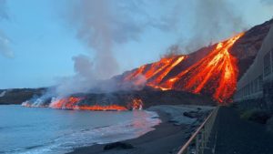
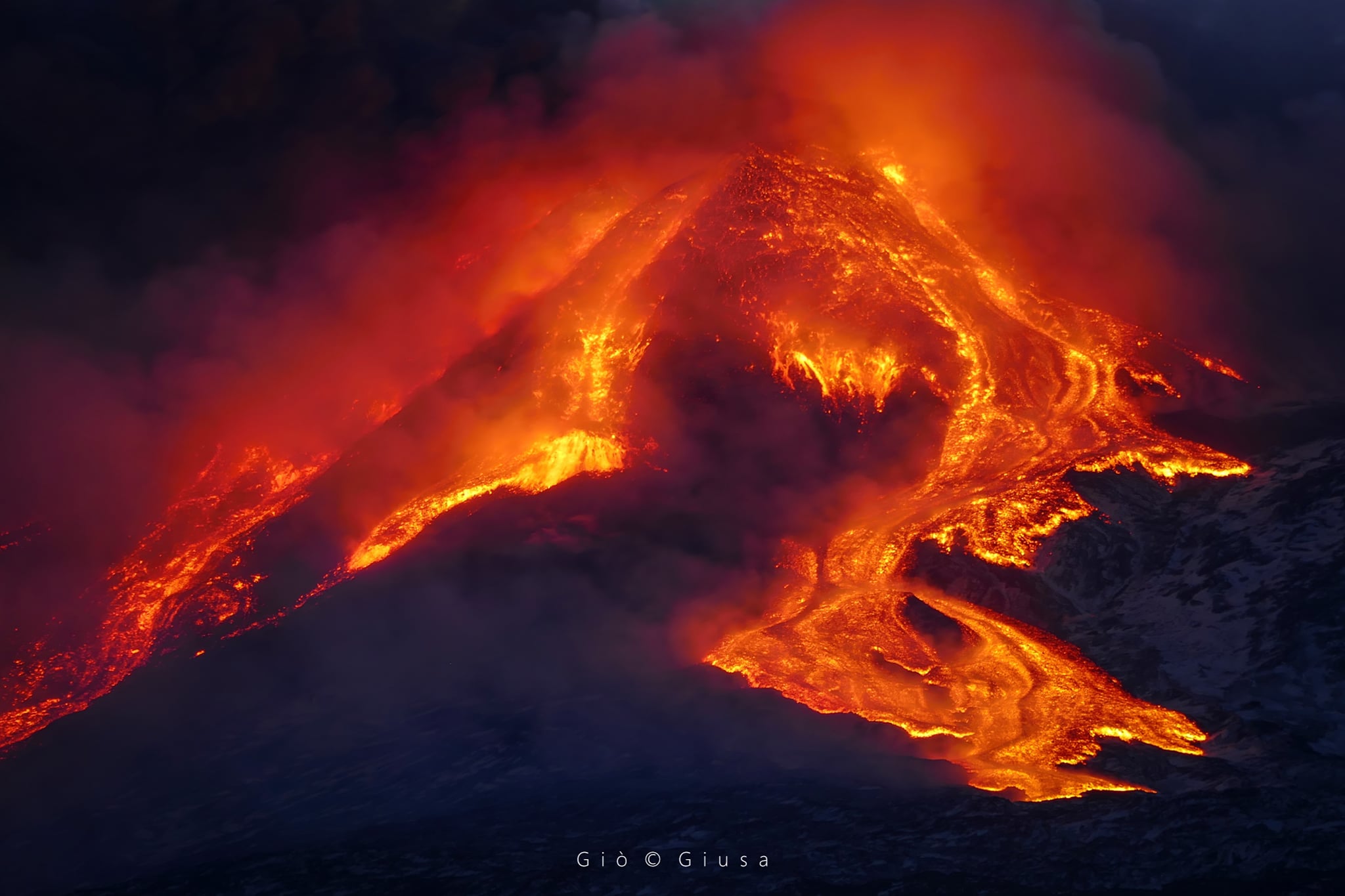
March 12, 2021, 08:13 (07:13 UTC): From 06:30 UTC, Strombolian activity at the Southeast Crater has further intensified; in addition, from 06:54 UTC, an overflow of lava is observed from the eastern area of the Southeast Crater which moves towards the Valle del Bove. At the moment, the lava front is at an altitude of about 3000 meters above sea level.
From the seismic point of view, the increase in the amplitude of the volcanic tremor continues to reach high values and the source of the tremor is located near the Southeast Crater at a depth of about 2.5 km above the level of the sea. The number of infrasound events is high and their location seems to be close to the Southeast Crater.
March 12, 2021, 09:09 (08:09 UTC): At 07:40 UTC, the Strombolian activity of the Southeast Crater turned into a lava fountain with jets reaching a height of about 500 meters above the crater. The lava flow produced by the overflow is fed and reached an altitude of about 2600 meters above sea level. According to the forecast model, the eruptive cloud produced by the current activity disperses towards ballast. Eruptive activity towards the other craters continues.
From the seismic point of view, the increase in the amplitude of the volcanic tremor continues to very high values, the source of the tremor is located near the Southeast Crater at a depth of about 2.5 km above the level. from the sea. The number of infrasound events is medium-high and their location seems to be close to the Southeast Crater.
The data from the GNSS network does not show significant variations, while the inclinometric network shows modest variations (0.1 – 1 microradians) related to the current activity.
Further updates will be communicated shortly.
Source : INGV.
Photos : INGV , Gio Giusa ( Cratère du Sud Est , Etna 16/02/2021 ).
Guatemala , Pacaya :
SPECIAL VOLCANOLOGICAL BULLETIN March 11, 2021, 1:17 p.m. local time
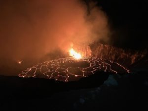
As part of the monitoring of the eruption of the Pacaya volcano and the BEPAC-50-2021 bulletin, it is reported that in the last hours, the eruptive activity continues to record increasing pulses that produce thick columns of ash at altitudes of 3,500 meters above sea level and the expulsion of ballistic projections at altitudes between 250 and 800 meters above the Mackenney crater, which fall within a radius of approximately 500 meters around it. Explosive activity and ash emissions have occurred more frequently in cracks formed on the southern flank 300 meters below Mackenney Crater, although they sometimes eject material as well.
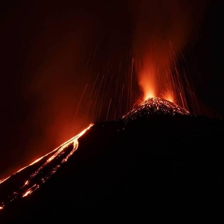
This activity occasionally caused ash falls in the villages of El Patrocinio and San José El Rodeo, in the municipality of San Vicente Pacaya. According to reports from OVPAC observers and GOES-16 satellite images, this material dispersed downwind, mainly to the west and southwest, over distances between 15 and 30 km. This activity produced explosive or rumbling sounds very sporadically. Effusive activity continues on the southern flank, with two lava flows maintaining lengths of around 1,000 meters. This activity also results in high values of thermal and radiation anomalies over the past few days, measured from satellite images.
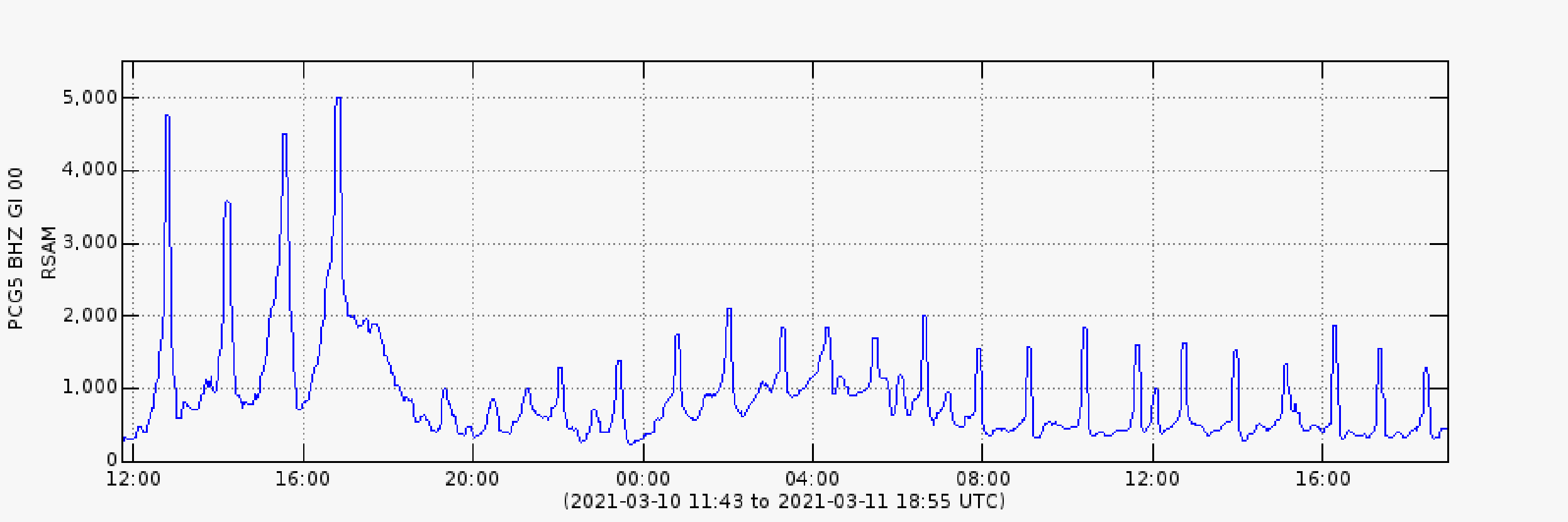
The log of the mean seismic amplitudes (RSAM) of the PCG5 station in the figure above, shows 22 increment pulses since the publication of the previous special bulletin, at 16:00 UTC yesterday.
Taking into account the behavioral model that the Pacaya volcano has shown in recent weeks, it is not excluded that increasing impulses will continue to appear in the coming hours or days, generating explosions, eruptive columns, sources of incandescent materials , ash and ballistic falls, and / or the appearance of new lava flows or the increase in their length.
Source : Insivumeh .
Photo : Diegorizzophoto.
Ecuador , Sangay :
DAILY REPORT OF THE STATE OF THE SANGAY VOLCANO, Thursday March 11, 2021.
Surface activity level: High, Surface trend: No change.
Internal activity level: High, Internal trend: No change.
Seismicity: From March 10, 2021, 11:00 a.m. to March 11, 2021, 11:00 a.m .:
The reference station stopped transmitting data from around 1:00 p.m. TL yesterday, which is why the seismic statistics are incomplete.
Explosion (EXP) 19
Long period (LP) 4
Tremors of emission (TREMI) 3
Rains / lahars:
In the early morning and yesterday, there were several episodes of rain in the area.
** In the event of heavy rains, these could re-mobilize the accumulated materials, generating mudslides and debris that would descend the sides of the volcano and flow into the adjacent rivers. **

Emission / ash column: On the cameras it was not possible to observe the emissions; However, the VAAC recorded 5 ash emission alerts observed by satellites at altitudes of 1,500 to 8,500 meters above crater level. The directions of these emissions varied from the North, Northwest and West of the volcano; we are currently observing on the satellites the movement of the ash cloud in these directions
Other monitoring parameters: During the last 24 hours, there are no reports of thermal alerts regarding the Sangay volcano.
Observations: The cloudiness was permanent in the area, preventing direct observation of surface activity. In the images shared by the Volcanic Observers Network (ROVE) and in the ECU911 report, high intensity ash fall was recorded in the township of Guamote; moderately in the townships of Chambo, Riobamba, Penipe and Guano; and slightly to Colta, Alausí and Macas.
The eruption of the Sangay volcano this morning, March 11, produced pyroclastic flows towards the south-eastern flank (Volcán river). The accumulated volcanic material can be easily remobilized by precipitation, forming secondary lahars or mudslides and debris. It is recommended not to be in areas close to the banks of the Volcán and Upano rivers. This phenomenon has been recurring since the reactivation of the volcano in May 2019.
Alert level: yellow.
Sources :INSTITUTE OF GEOPHYSICS / NATIONAL SCHOOL OF POLYTECHNIQUE.
Photo : Yong Soo Seung.
Japan , Suwanosejima :
JMA reported intermittent eruptive events at Suwanosejima’s Ontake Crater during 26 February-2 March. Bombs were ejected as far as 600 m away from the crater and ashfall was reported in Toshima village (4 km SSW). The number of explosions began increasing on 2 March; the total recorded through 1500 on 7 March was 139, but by 1500 on 8 March there was only one additional explosion.
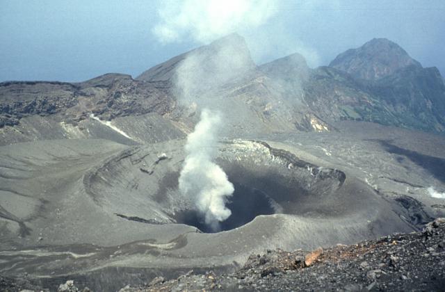
The Tokyo VAAC reported that ash plumes rose 0.9-2.1 km (3,000-7,000 ft) a.s.l. during 3-7 March. An explosion at 0317 on 6 March ejected tephra as high as 500 m above the crater rim and bombs 900 m away. The Alert Level remained at 2 (on a 5-level scale).
Source : GVP.
Photo : Yukio Hayakawa, 1998 (Gunma University).