March 13 , 2021 .
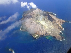
Italy / Sicily , Etna :
Almost as punctual as a clock, the twelfth climax. Etna, March 12, 2021
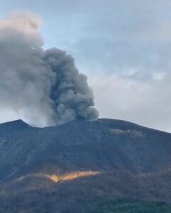
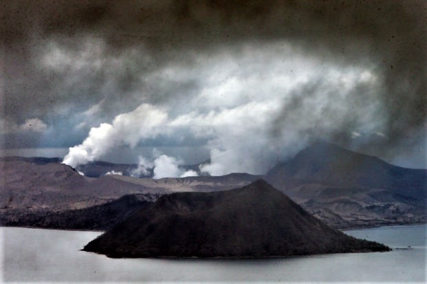
In the early hours of March 12, 2021, Etna, almost as precise as a clock, recorded the start of new Strombolian activity at the Southeast Crater (CSE) of modest intensity, while at the same time l Intra-crater explosive activity continued at Voragine, Bocca Nuova and Northeast Crater. Almost immediately, the average amplitude of the volcanic tremor showed a marked increase reaching high values, as the sources of the tremor moved under the Southeast Crater (SSC) to a depth of about 2.5 km. It was the prelude to a new paroxysmal episode, the twelfth in just under a month (Figure 1).
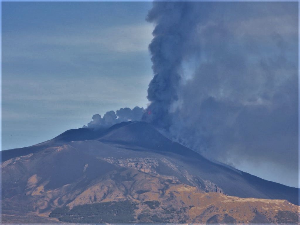
Figure 1 – Paroxysm of March 12, 2021 seen from Tremestieri Etneo, south side of Etna. Photo by Boris Behncke, INGV-OE.
From 6.30 a.m. (local time), Strombolian activity at the Southeast Crater increased in intensity and frequency, producing an eruptive cloud. A further increase in Strombolian activity was recorded from 7:54 a.m., accompanied by an overflow of lava from the eastern area of the Southeast Crater, which extended towards the Valle del Bove.
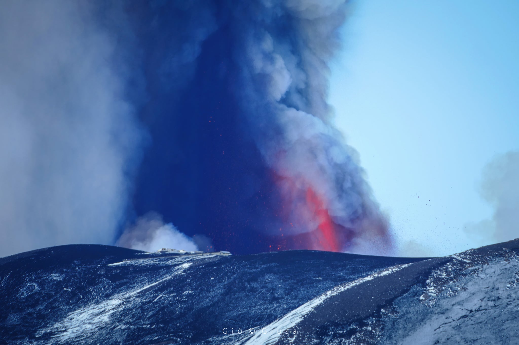
At 8:41 a.m., Strombolian activity shifted to the lava fountain stage, with the formation of an eruptive cloud that reached a height of about 6000 m above sea level, carried by easterly winds. The lava flow continued to expand towards the Valle del Bove, reaching an altitude of about 2800 m above sea level.
At 9:39 a.m., the eruptive cloud produced by the current activity reached an altitude of about 8,500 meters (Figure 2), dispersing to the east. The ash fall affected the towns of Fornazzo and Giarre, then those of Milo, Santa Venerina and Torre Archirafi. The front of the lava flow that extended into the Valle del Bove reached an altitude of about 2000 m above sea level.
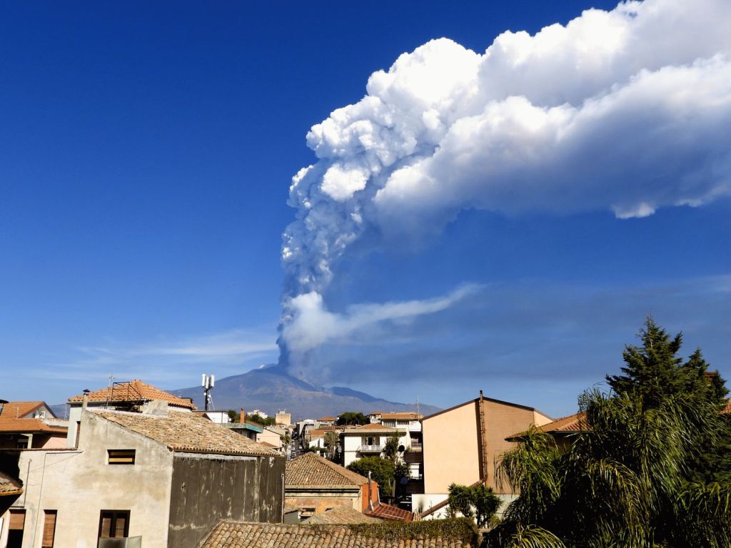
Figure 2 – Paroxysm of March 12, 2021 seen from Tremestieri Etneo, south side of Etna. Photo by Boris Behncke, INGV-OE.
The activity of the lava fountain ceased at 10:50 am; weak Strombolian activity and ash emissions at the Southeast Crater continued for some time. By 11:15 a.m., the activity was almost over. The main lava flow continued to be moderately fed, with a lava front descending to around 1,700m above sea level. A second lava flow was also observed which extended to the south-east on the west side of the Valle del Bove up to an altitude of about 3000 m above sea level and also appears to be no longer fed and cooled.
The average amplitude of the volcanic tremor decreased rapidly, remaining at a medium-low level. The analysis of the deformations of the soil, in particular of the inclinometric data which are the most sensitive, showed, also in this case, small variations in different stations, with maximum values (in any case less than 3 microradians) recorded by the Crater del Piano station (ECP). The GNSS network data, on the other hand, does not show significant variations.
The twelfth climax in the streak that began in February 2021 occurred about 54 hours after the previous one.
At the time of publication of the news, the eruptive activity at the summit craters of Etna continues, but not in a paroxysmal form, and is constantly monitored by the INGV-OE. Researchers from the institute are in the field to sample erupting products and map their distribution.
Source : INGV.
Photos : Boris Behncke / INGV, Gio Giusa .
Iceland , Reykjanes Peninsula :
Tonight Mars 13. Just over 560 earthquakes have been detected. Of measured quakes 6 measured above M3.0, one by Mt. Trölladingja other by SW-Fagradalsfjall. The largest earthquake was there at 01:34am of M4.6. It was felt in widely in SW Iceland, north to Borgarnes and east to Fljótshlíð.
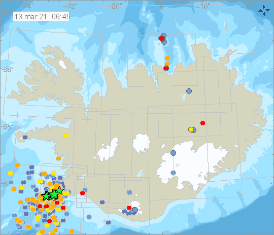
Yesterday, Mars 12., nearly 3000 earthquakes have been detected by IMO‘s SIL automatic earthquake system. There of 48 earthquakes measured above M3.0, the largest at 07:43 of M5.0. All these quakes were located in southern part of Fagradalsfjall. At 22:39 a M3.9 earthquake was felt in SW-Iceland.
Source : Vedur .
Kamchatka , Klyuchevskoy :
56.06 N, 160.64 E;
Elevation 4750 m (15580 ft)
Aviation Colour Code is ORANGE
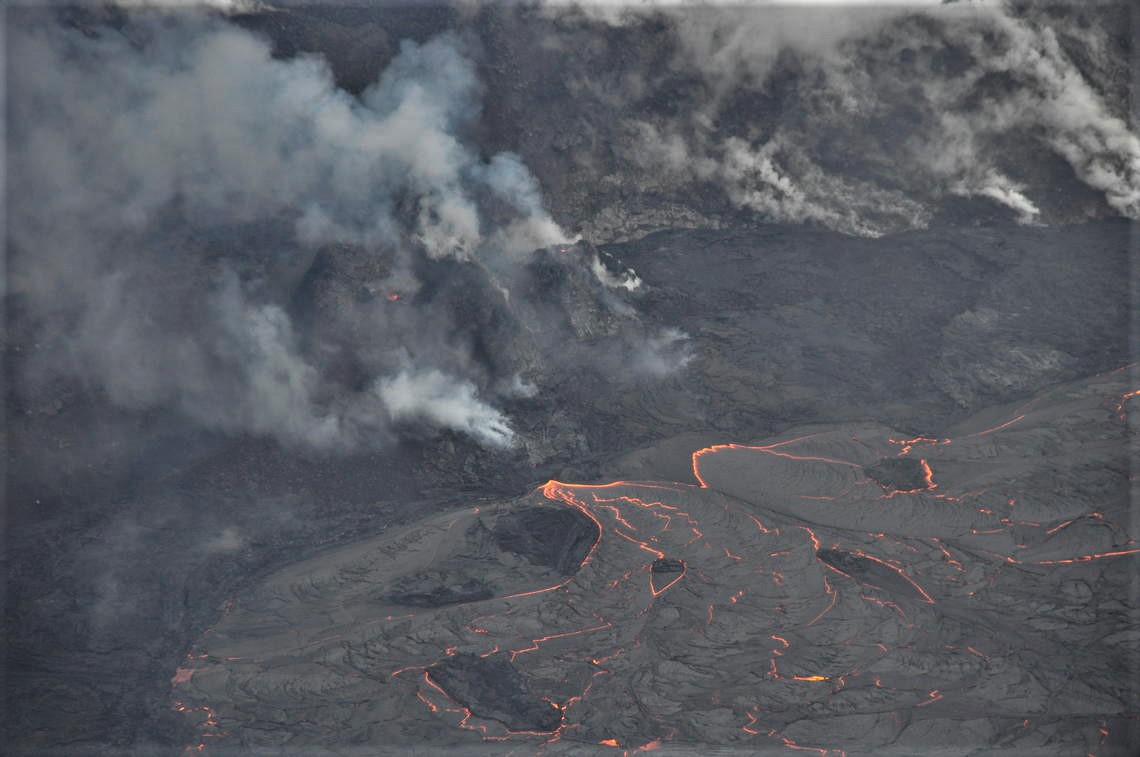
A moderate explosive-effusive flank eruption continues. The danger of ash explosions up to 5-6 km (16,400-19,700 ft) a.s.l. from the flank crater and the lava flow front (phreatic explosions at the contact of the flow with the Erman glacier) remains. Ongoing activity could affect low-flying aircraft.
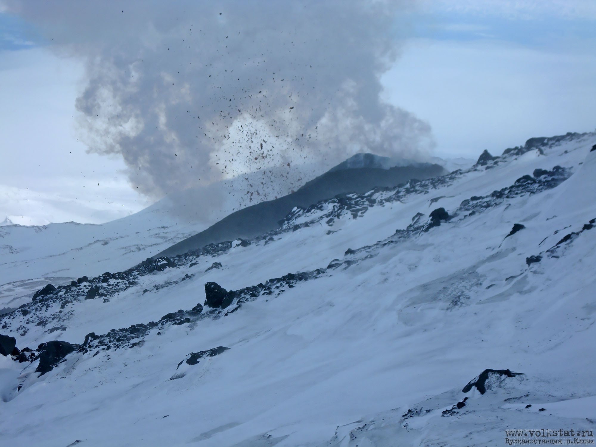
The flank eruption on the northwestern slope of the volcano at an altitude of 2800 m a.s.l. with Strombolian activity of the cinder cone, and the lava flow effusing, continues. The fumarole activity of the volcano also continues. According to satellite data, a bright large thermal anomaly was observed all week in the area of the flank eruption; a plume of resuspended ash from the eastern volcanic flank extended for 375 km to the east of the volcano on 05 March.
Source : Kvert .
Photo : Volkstat ru / Yu Demyanchuk.
Philippines , Taal :
TAAL VOLCANO BULLETIN 13 March 2021 08:00 A.M.
In the past 24-hour period, the Taal Volcano Network recorded fifty-five (55) volcanic earthquakes, including forty-nine (49) episodes of volcanic tremor having durations of one (1) to two and a half (2.5) minutes. At 2:11 PM yesterday, a short-lived 400-500 meter-tall white plume was generated by a burst of steam-rich gas from the Main Crater that lasted 2.5 minutes based on seismic records. Activity at the Main Crater for the rest of the day consisted of weak emission of steam-laden plumes that rose 50 meters high from active fumaroles on the northern and eastern walls. Sulfur dioxide (SO2) emission yesterday, 12 March 2021, averaged 582 tonnes/day prior to the gas burst event. Temperature highs of 71.8°C and pH of 1.59 were last measured from the Main Crater Lake respectively on 04 March and 12 February 2021. Ground deformation parameters from electronic tilt, continuous GPS and InSAR data analysis indicated a very slow and steady inflation and expansion of the Taal region since after the January 2020 eruption. These parameters may indicate increased magmatic activity at shallow depths beneath the edifice.
Alert Level 2 (Increased Unrest) is maintained over Taal Volcano. DOST-PHIVOLCS reminds the public that at Alert Level 2, sudden steam-driven or phreatic explosions, volcanic earthquakes, minor ashfall, and lethal accumulations or expulsions of volcanic gas can occur and threaten areas within the Taal Volcano Island (TVI). DOST-PHIVOLCS strongly recommends that entry into TVI, Taal’s Permanent Danger Zone or PDZ, especially the vicinities of the Main Crater and the Daang Kastila fissure, must remain strictly prohibited. Local government units are advised to continuously assess and strengthen the preparedness of previously evacuated barangays around Taal Lake in case of renewed unrest. Civil aviation authorities must advise pilots to avoid flying close to the volcano as airborne ash and ballistic fragments from sudden explosions and wind-remobilized ash may pose hazards to aircraft.
DOST-PHIVOLCS is closely monitoring Taal Volcano’s activity and any new significant development will be immediately communicated to all stakeholders.
Source : Phivolcs
Photo : EDWIN BACASMAS.
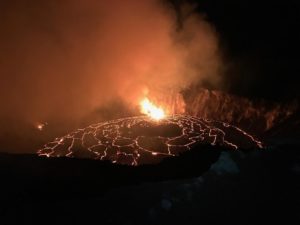
Hawaii , Kilauea :
19°25’16 » N 155°17’13 » W,
Summit Elevation 4091 ft (1247 m)
Current Volcano Alert Level: WATCH
Current Aviation Color Code: ORANGE
Activity Summary:
Kīlauea Volcano is erupting. Laser rangefinder measurements this morning, March 12, indicate that the total depth of the lava lake is 221 m (725 ft). SO2 emission rates remain elevated; a measurement on March 7 was 800 t/day.
Summit Observations:
The most recent sulfur dioxide emission rate, measured on March 7, is 800 t/d; this is elevated compared to rates in the months before the eruption started on December 20 (less than 100 t/day), but lower than rates from the pre-2018 lava lake (around 5,000 t/day). Summit tiltmeters tracked deflationary tilt over the past 24 hours, which continues this morning as part of an apparent deflation-inflation (DI) event. Seismicity remains stable, with elevated tremor compared to observations before the eruption.
View looking to the northwest of western fissure area of Halema‘uma‘u lava lake at the Kīlauea summit on March 11, 2021. There is a small incandescent opening at the top of the main (southern) west vent spatter cone (middle-left), and a few smaller incandescent openings at the top of the northern west vent spatter cone (right of the main cone). The northern west vent spatter cone was the source of a lava flow this past weekend. There are now two effusion (eruption) points at the base of the spatter cones, one at the base of each spatter cone. The northern effusion point is the weaker of the two.
Halemaʻumaʻu lava lake Observations:
Lava effusion from the west vent continues to supply the lava lake within Halema‘uma‘u crater. The main section of the west vent is consistently effusing lava through a crusted-over channel and submerged inlet to the lake.
The northeast section of the west vent, just several meters (yards) away, has been feeding another lava flow near the lake since March 5. After the collapse of a lava pond near the west vent on March 7, this flow stabilized into a second semi-steady inlet to the lava lake, which persists as of this update.
Lava circulation and intermittent foundering of thin crust continue in the active western portion of the lava lake. The total depth of the lake is approximately 221 m (725 ft) as measured by a continuous laser rangefinder this morning.
Source : Hvo .
Photo : USGS/ N. Deligne.