February 17 , 2021 .
Italy , Stromboli :
Weekly bulletin from February 08, 2021 to February 14, 2021, (issue date February 16, 2021)
SUMMARY OF THE STATE OF ACTIVITY
In the light of surveillance data, it is highlighted:
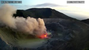
VOLCANOLOGICAL OBSERVATIONS: Normal explosive volcanic activity of Strombolian type with intense projection activity in the North zone. The total frequency of events showed values ranging from medium levels (10 events / h) to medium-high levels (19 events / h). The intensity of the explosions was mainly medium-high in the areas of the North and Center-South craters.
2) SEISMOLOGY: The monitored seismological parameters do not show significant variations
.
3) DEFORMATIONS: The island’s soil deformation monitoring networks did not show any significant changes to report for the period under review.
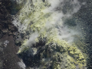
4) GEOCHEMISTRY: The flow of SO2 occurs at an average level.
C / S ratio: values are at high levels (C / S = 18.3).
The helium isotopic ratio is at high values (R / Ra = 4.42 compared to the sampling of February 5, 2021).
5) SATELLITE OBSERVATIONS: The thermal activity in the summit area is at a moderate-low level.
VOLCANOLOGICAL OBSERVATIONS
In the period under observation, the eruptive activity of Stromboli was characterized by the analysis of the images recorded by the surveillance cameras INGV-OE located at an altitude of 190 m, Punta Corvi and 400 m.
Due to the cloud cover on February 11, the visibility of the crater terrace was insufficient for a correct description of the eruptive activity.
In the area of the North crater, the N1 crater, with three emission points, produced explosions of low intensity (less than 80 m high) to medium-high (sometimes the projectiles reached 250 m high) emitting materials. coarse (lapilli and bombs) mixed with ash. The N2 mouth, with four emission points, showed mainly low to medium-high intensity explosive activity (sometimes the products reached 250 m in height) emitting coarse materials.
In addition, projection activity was observed at the N2 vent which was intense both in terms of frequency and height reached by the lava shreds on February 8-10-13. The average frequency of the explosions varied from 9 to 15 events / h.
In the Center-South zone, the explosions emitted mixed / coarse ash emissions, with an average and sometimes high intensity (the products exceeded 250 m in height). The explosive activity showed average hourly frequency values between less than 1 and 4 events / h.
During the week, the amplitude of the tremor had medium-low values.
Source : INGV.
Photos : Webcam , INGV.
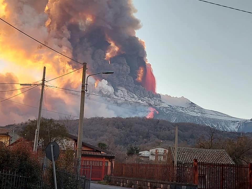
Italy / Sicily , Etna :
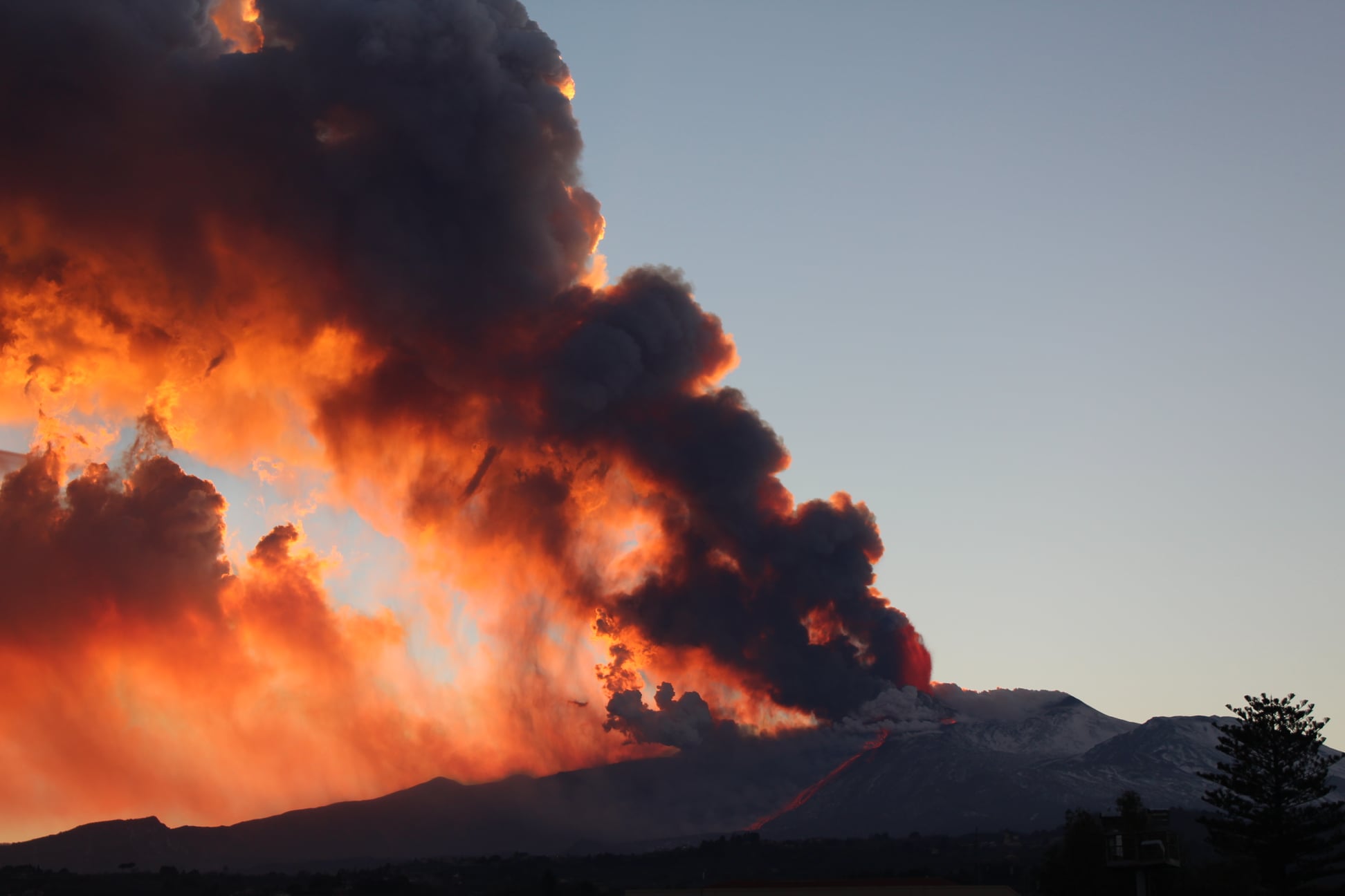
The phenomenon produced a cloud of ash which was quickly dispersed by the high winds to the south.
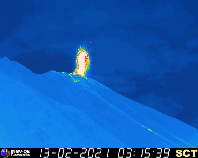
On the seismic level, the average amplitude of the volcanic tremor during the last hours has remained on high values and since 16:00 hours, UTC, we observe a significant increase, with a sudden increase.
The source of the tremor remains confined below the south-eastern crater in a depth range between 2900 and 3000 meters above sea level.
The increase in tremor is accompanied by violent infrasound activity with signs of great magnitude.
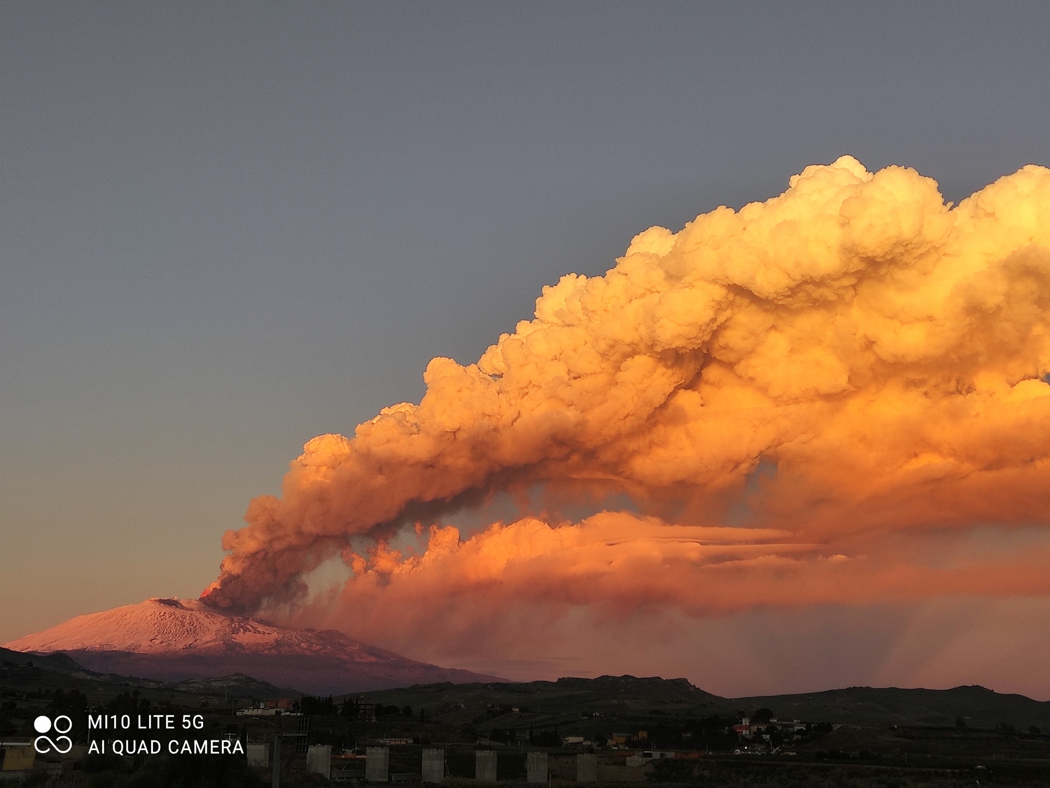
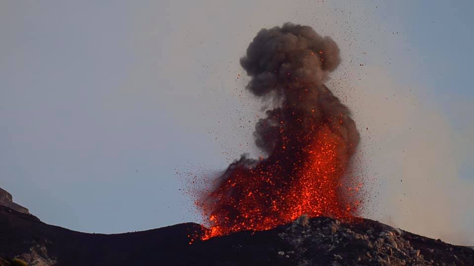
VOLCANIC ACTIVITY RELEASE of February 16, 2021, 19:25:48 (UTC) – ETNA.
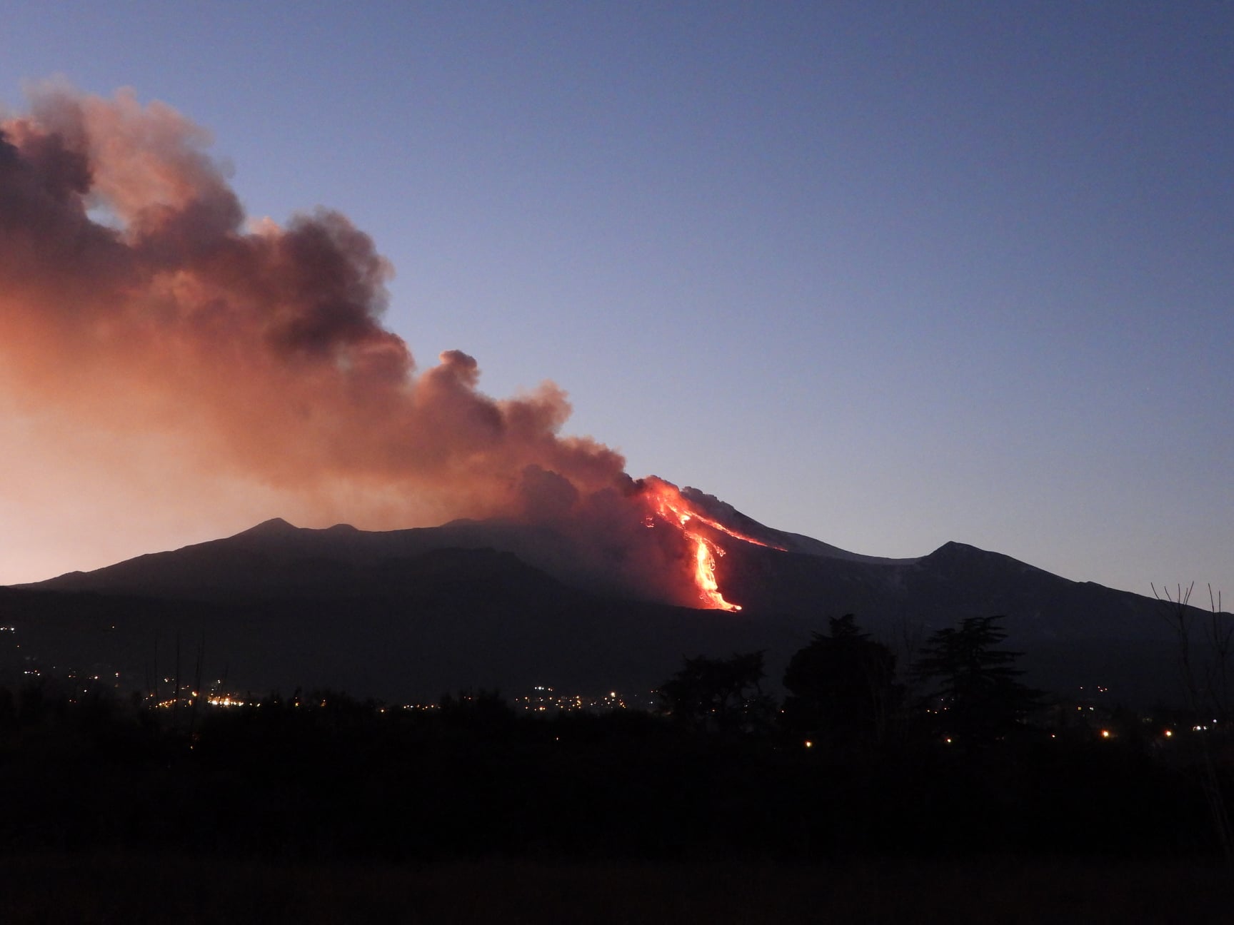
The National Institute of Geophysics and Volcanology, Etneo Osservatorio, announces that after the end of the lava fountain episode (17:00 UTC), the lava emission from the Southeast Crater gradually decreased. Currently, the lava flows no longer seem to be powered, and in their most advanced part, they are advancing slowly. In particular, the main lava flow that heads towards the central part of the Valle del Bove, after having traveled a few kilometers. The other small lava flows, which develop in the North and South, advance slowly and have reached an altitude of about 2,900 meters. At the same time, intracrater explosive activity continues unchanged in the craters of Voragine, Bocca Nuova and Southeast.
The average amplitude of the volcanic tremor continues to show a decreasing trend. It has currently reached values within the middle range. The source of the tremor is located under the Southeast Crater in a depth range between 2800 and 2900 meters above sea level.
The infrasonic activity also shows a markedly decreasing trend, with low values both in the rate of occurrence and in the mean amplitude of infrasonic transients.
The distortion data from the GPS network did not show any significant variations, while the contained variations (0.1 – 1 microradians) detected by the inclinometric network stopped.
Further updates will be communicated shortly.
Weekly bulletin from February 08, 2021 to February 14, 2021, (issue date February 16, 2021)
SUMMARY OF THE STATE OF ACTIVITY.
In the light of surveillance data, it is highlighted:
VOLCANOLOGICAL OBSERVATIONS:
Strombolian activity of variable frequency and intensity accompanied by discontinuous ash emissions at the Southeast crater. Strombolian activity with sporadic ash emissions and intracrater effusive activity at the Voragine crater. Strombolian activity at the Bocca Nuova crater and intracrater Strombolian activity at the Northeast crater with occasional ash emissions.
2) SEISMOLOGY: Modest fracturing seismic activity; amplitude of the volcanic tremor constantly in the high level.
3) INFRASONO: moderate infrasound activity.
4) DEFORMATIONS: During the last week, the trend of the time series of the Etna soil deformation monitoring networks has not shown any significant changes.
5) GEOCHEMISTRY: The flow of SO2 is at a medium-high level
HCl flux occurs at a high level.
The CO2 flux from the soil remains at average levels.
The partial pressure of dissolved CO2 does not show significant changes.
There are no updates for the C / S report.
The isotopic ratio of helium is at medium-high values (last update 27/01/2021).
6) SATELLITE OBSERVATIONS: The thermal activity in the summit area is at a moderate level.
VOLCANOLOGICAL OBSERVATIONS
During the week, the monitoring of the volcanic activity at the level of the summit craters of Etna was carried out by analyzing the images of the network of surveillance cameras of the INGV section of Catania, Osservatorio Etneo (INGV-OE). The alternating weather conditions during the week made the observation of volcanic activity discontinuous through the network of surveillance cameras.
During the period considered, the activity of the Etna volcano followed the behavior observed in previous weeks, characterized by an eruptive activity of varying intensity of the four summit craters.
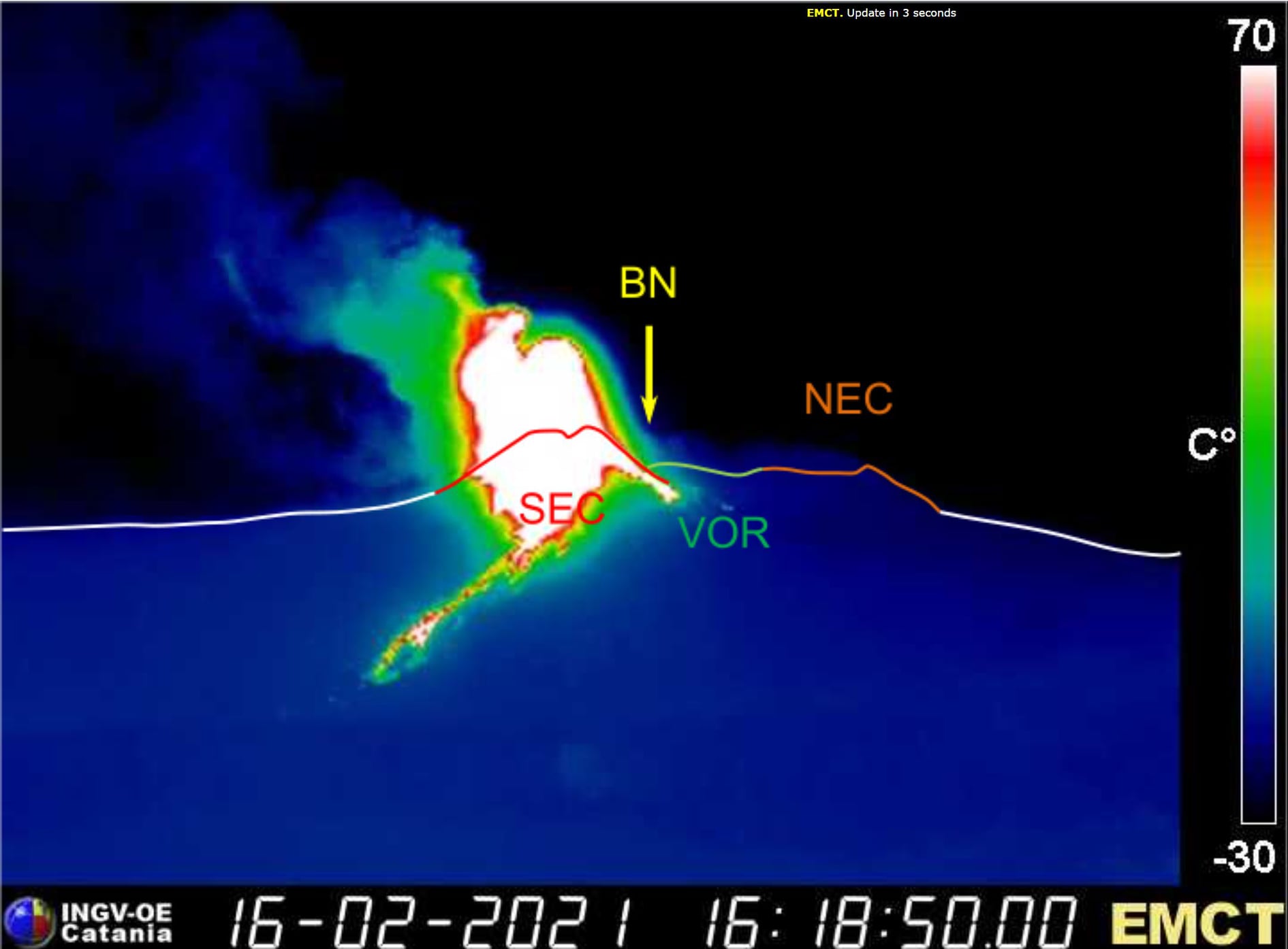
In particular, Strombolian activity continued at the Southeast Crater (SEC) with explosions of varying frequency and intensity over time. The strongest and almost continuous explosive activity was generated by the two vents in the eastern sector of the cone top area. Coarse material ejected during explosive activity accumulated in the upper parts of the cone, rolling due to the steep slope and quite frequently descended along the steep walls of the cone even for several tens of meters. The explosions produced by these vents were sometimes accompanied by low ash emissions which quickly dispersed into the atmosphere in the summit area.
The vent active in the southern sector of the Southeast Crater (SEC) cone was rather characterized by a Strombolian activity of a more discontinuous frequency and of a lower intensity than that which affected the two vents of the eastern sector.
In addition, during the week, the Northeast Crater (NEC) fueled intra-crater Strombolian activity of varying intensity, highlighted at night by a discontinuous glow visible from the cameras of the video surveillance.
In the period in question, the crater of Bocca Nuova (BN) produced Strombolian activity, characterized by the launching of coarse materials even beyond the edge of the crater, sometimes accompanied by rare emissions of very diluted ash.
Finally, the strombolian activity of the Voragine crater (VOR) continued, with projections of coarse material at heights that often exceeded the edge of the crater and sporadic emissions of diluted ash.
Source : INGV.
Photos : INGV , Agatino Reitano , Melania Vasta ,Boris Behncke , Alessandro Leone .
Philippines , Taal :
TAAL VOLCANO BULLETIN 17 February 2021 08:00 A.M.
In the past 24-hour period, the Taal Volcano Network recorded sixty-nine (69) tremor episodes having durations of one (1) to five (5) minutes. Activity in the Main Crater consisted of weak emission of white steam-laden plumes from fumaroles that rose 20 meters high. Temperature highs of 77.1°C and pH of 1.59 were last measured from the Main Crater Lake on 12 February 2021. Ground deformation parameters from continuous electronic tilt on Volcano Island record a slight deflation around the Main Crater since October 2020 but overall, very slow and steady inflation of the Taal region has been recorded by continuous GPS data after the eruption.
These tremor episodes ranged in duration from two (2) to five (5) minutes and occurred at shallow depths of <1km, signaling increased hydrothermal activity beneath Taal Volcano Island (TVI). Since 13 February 2021, a total of one hundred sixty eight (168) shallow tremor episodes have occurred in TVI. Furthermore, geochemical data on the Main Crater Lake indicate a continuous acidification of lakewater from a pH 2.79 to pH 1.59 between January 2020 and February 2021, an unseasonal temperature high of 77ºC and CO2/H2S gas flux ratios consistent with shallow magma degassing. Ground deformation data from continuous electronic tilt on Volcano Island record a slight deflation localized around the Main Crater, although very slight inflation from GPS data and InSAR analysis and positive microgravity changes have been steadily recorded across the Taal region consistent with continuous magmatic degassing and hydrothermal unrest.
Source : Phivolcs .
Photo : Raffy Tima.
Indonesia , Semeru :
Level of activity level II (WASPADA). G. Semeru (3,676 m above sea level) is continuously erupting with explosive and effusive eruptions, causing lava flows towards the south and south-eastern slopes, as well as explosions of incandescent rocks around the summit crater.
The volcano was clearly visible until it was covered in fog. Smoke from the crater was not observed. The weather is sunny to rainy, the winds weak to moderate in the North, North-East and East. The air temperature is around 21-27 ° C.
According to the seismographs of February 16, 2021, it was recorded:
81 eruption / explosion earthquakes.
4 emissions earthquakes
1 harmonic earthquake
3 distant tectonic earthquakes.
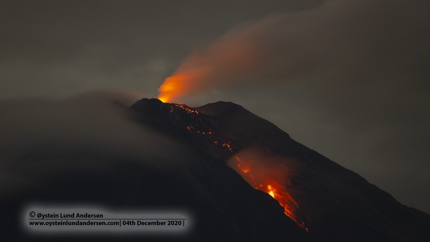
VOLCANO OBSERVATORY NOTICE FOR AVIATION – VONA.
Issued : February 16 , 2021
Volcano : Semeru (263300)
Current Aviation Colour Code : ORANGE
Previous Aviation Colour Code : orange
Source : Semeru Volcano Observatory
Notice Number : 2021SMR05
Volcano Location : S 08 deg 06 min 29 sec E 112 deg 55 min 12 sec
Area : East java, Indonesia
Summit Elevation : 11763 FT (3676 M)
Volcanic Activity Summary :
Eruption with volcanic ash cloud at 23h01 UTC (06h01 local).
Volcanic Cloud Height :
Best estimate of ash-cloud top is around 12723 FT (3976 M) above sea level, may be higher than what can be observed clearly. Source of height data: ground observer.
Other Volcanic Cloud Information :
Ash-cloud moving to North
Source : PVMBG , Magma Indonésia .
Photo : Oystein lund Andersen .