January 19 , 2021 .
Italy , Stromboli :
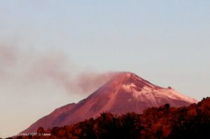
PRESS RELEASE, ACTIVITY ON STROMBOLI [n. 1]
The National Institute of Geophysics and Volcanology, Osservatorio Etneo, reports that the monitoring networks recorded a sudden change in the monitored parameters at 11:32 (10:32 UTC). In particular, a thermal anomaly is observed from the surveillance cameras.
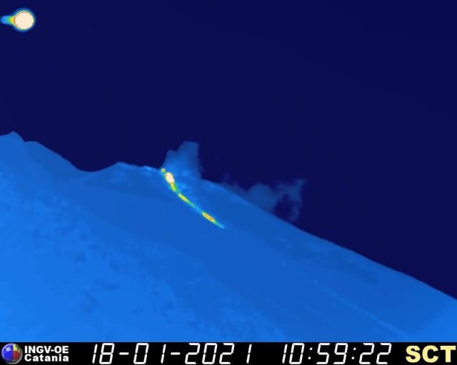
Image taken with a thermal camera of the lava overflow on Stromboli on January 18, 2021, around 12 p.m.
PRESS RELEASE, ACTIVITY ON STROMBOLI [n. 2]
The National Institute of Geophysics and Volcanology, Osservatorio Etneo, announces that starting at around 9.45 a.m. GMT, INGV-OE surveillance cameras show an overflow of lava coming from the area of the North crater.
The tremor shows no significant change.
Stromboli’s GPS and inclinometric networks do not show significant variations.
PRESS RELEASE, ACTIVITY ON STROMBOLI, [UPDATE n. 3]
The National Institute of Geophysics and Volcanology, Osservatorio Etneo, announces that the previously communicated lava overflow is produced by the N2 vent in the North crater area. This overflow, preceded overnight by splashing activity, was well fed between 10:10 GMT and 11:30 GMT approximately, reaching a height of about 700 m above sea level. From the analysis of the images from INGV CCTV cameras, glowing blocks were also visible that broke away from the front and rolled along the Sciara del Fuoco.
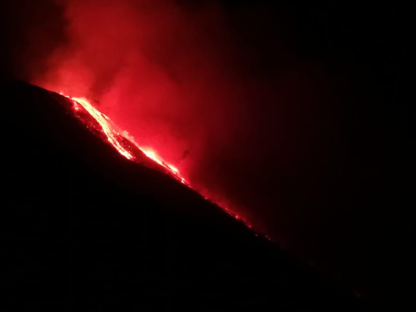
For the moment, this overflow is no longer supplied but a thermal anomaly remains visible from the CCTV cameras of the INGV-OE. There is also ordinary Strombolian activity of the North and Center South crater areas Tomorrow morning, INGV-OE personnel will fly over with the helicopter provided by the Catania Coast Guard.
From the point of view of the volcanic tremor, there is no significant change compared to the situation prior to the event in question. The amplitude of the tremor is substantially stationary, even the frequency and amplitude of transients attributable to explosive events do not show significant changes. The amplitude of these signals remains at relatively low levels.
Finally, from the observation of parameters relating to soil deformations, no significant change is detected.
PRESS RELEASE, ACTIVITY ON STROMBOLI, [UPDATE n. 5]
The National Institute of Geophysics and Volcanology, Osservatorio Etneo, announces that the analysis of the images recorded by the surveillance cameras INGV-OE shows that, as indicated in the previous press release, the projection activity continues in the area of the South Center crater. Such activity produces very visible glowing blocks that roll along the Sciara del Fuoco. Rather, the lava overflow from the North Crater area can be considered complete.
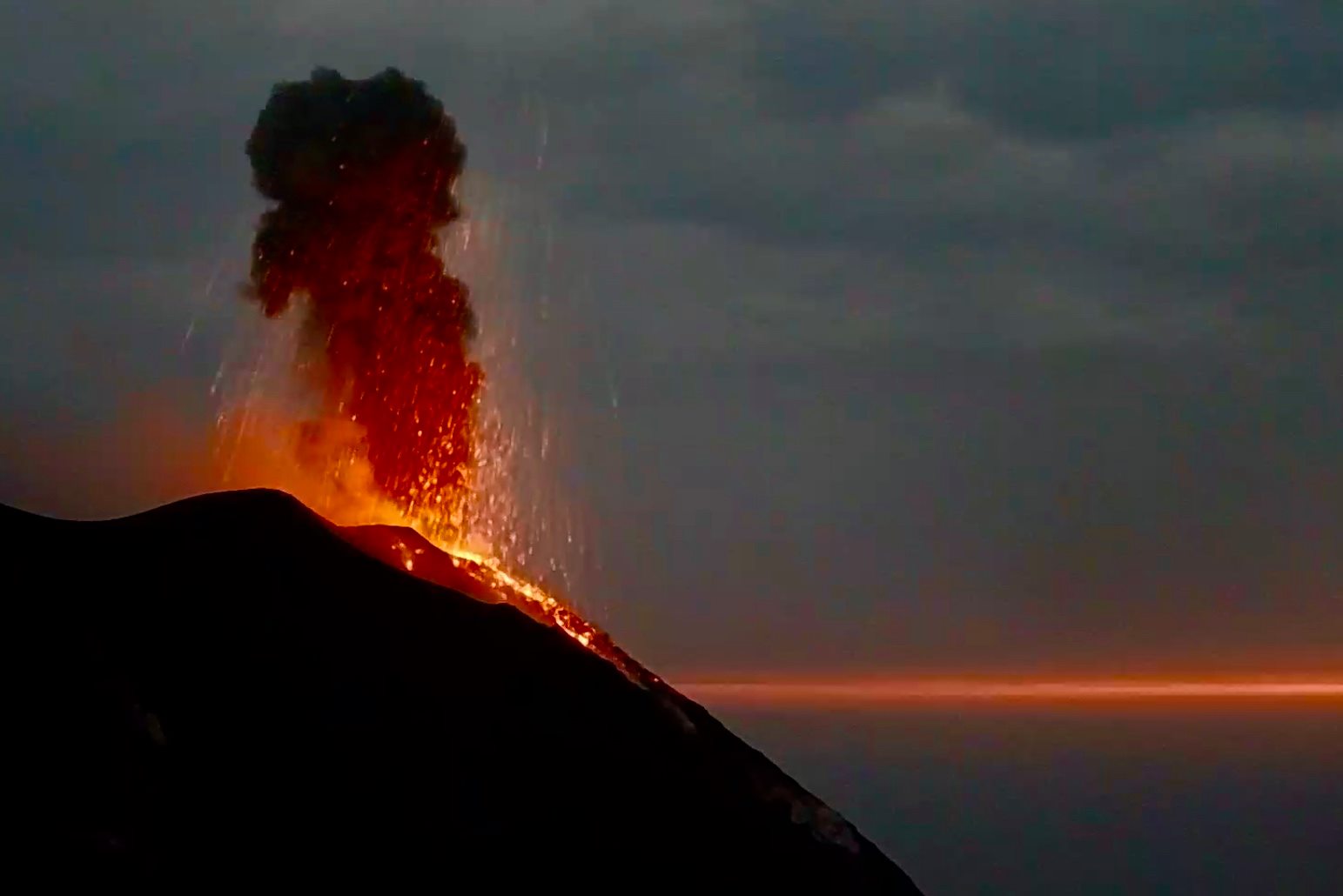
Compared to the previous situation, no significant change is noted. The amplitude of the tremor is stationary, as is the frequency and amplitude of transients attributable to explosive events. The amplitude of these signals remains relatively low.
Data from the Stromboli GPS network does not show significant variations.
Further updates will be communicated shortly.
Source : INGV.
Photos : INGV , A. Di Pietro (archives) , webcam.
Peru , Sabancaya :
Analysis period: from January 11, 2021 to January 17, 2021, Arequipa, January 18, 2021.
Alert level: ORANGE
The Geophysical Institute of Peru (IGP) reports that the eruptive activity of the Sabancaya volcano remains at moderate levels, that is, with the continuous recording of explosions with columns of ash and gas up to 3 km of altitude above the summit of the volcano and their consecutive dispersion. It has been reported the presence of a second lava dome, visible in the crater of the volcano. Therefore, for the following days, no significant change is expected in the eruptive activity.
The IGP recorded and analyzed the occurrence of 1778 earthquakes of volcanic origin, associated with the circulation of magmatic fluids inside the Sabancaya volcano. An average of 29 explosions were recorded daily of low to medium intensity. During this period, Volcano-Tectonic (VT) earthquakes associated with rock fractures were located mainly in the North-East and North-West of Sabancaya and presented magnitudes between M1.9 and M2.2. The most representative earthquake (M2.2) was recorded on January 14 at 12:17 p.m., 4 km northeast of Sabancaya and 6 km deep.
The monitoring of the deformation of the volcanic structure using GNSS techniques (processed with fast orbits) does not present any significant anomalies. However, in general, an inflation process has been observed in the south-eastern sector of Sabancaya and in the north sector (Hualca Hualca volcano). Visual surveillance made it possible to identify columns of gas and ash up to 3 km altitude above the summit of the volcano, which were scattered towards the South, South-East, North-West, West and South sectors. Western Sabancaya. Satellite monitoring has identified the presence of a thermal anomaly, with values of 2 MW, associated with the presence of a lava dome on the surface of the volcano crater.
RECOMMENDATIONS
• Keep the volcanic alert level in orange.
• Do not approach within a radius of less than 12 km from the crater.
Source : IGP.
Photo : archive ingemmet.
Italy / Sicily , Etna :
PRESS RELEASE, ACTIVITY ON ETNA [UPDATE n. 117]
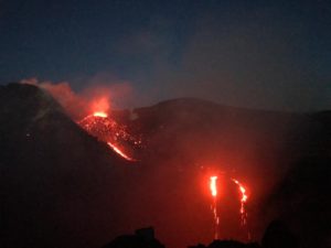
The National Institute of Geophysics and Volcanology, Osservatorio Etneo, announces that the analysis of the images of the surveillance cameras INGV-OE shows, from 19:15 GMT, a new overflow of lava produced by the Southeast crater. it heads towards the Valle del Bove and reaches a length of about 2900 m.
The lava overflow communicated in update no. 115 had in fact ceased. There is currently intense Strombolian activity from the Southeast Crater.
From 19:00 UTC, there is an increase in the amplitude of the volcanic tremor, which is currently reaching high values. At the same time, there is also an increase in infrasound tremor.
Etna’s GPS network data does not show significant variations.
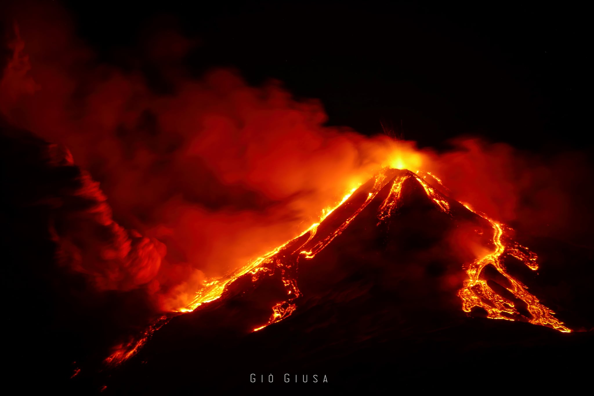
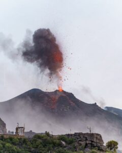
The paroxysmal activity of the Southeast Crater of Etna in the last few hours seems to have subsided (for the moment). Here is a picture of the « grand finale » with several lava overflows on the Southeast and Northeast side of the cone.
PRESS RELEASE, ACTIVITY ON ETNA [UPDATE n. 119]
The National Institute of Geophysics and Volcanology, Osservatorio Etneo, reports that the intense Strombolian activity produced by the Southeast Crater, described in the previous press release, suddenly evolved into a weak lava fountain reaching its maximum intensity around 8:30 p.m. GMT. This activity generated a volcanic cloud which dispersed east-south-east and formed a deposit of volcanic ash on the eastern flanks of the volcano. In fact, during the explosive activity, a fall of volcanic ash was reported in Fleri. Explosive activity waned dramatically as of 9:00 p.m. GMT. As for the effusive activity, the CCTV cameras of the INGV-OE show, as previously communicated, two distinct lava flows: one goes towards the East, inside the Valle del Bove, the another to the north.
From 21:00 UTC, a rapid decrease in volcanic tremor and infrasound signal was recorded. At around 9:30 p.m. UTC, both signals reached the levels that preceded the eruptive activity.
The deformation data does not show significant changes.
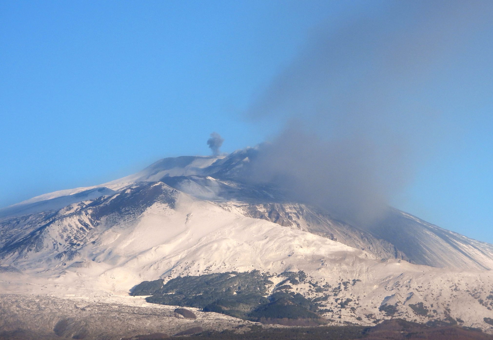
This morning, January 19, 2021, Etna is calm again … so to speak. The paroxysmal episode ended before midnight yesterday. Activity has returned to modest levels, with low Strombolian activity and periodic ash emissions at the Southeast Crater and sporadic explosions at the Voragine crater, sometimes even with low ash emissions from the Bocca Nuova crater.
PRESS RELEASE, ACTIVITY ON ETNA, [UPDATE n. 120]
The National Institute of Geophysics and Volcanology, Osservatorio Etneo, announces that the analysis of images from the INGV-OE CCTV cameras shows that the volcanic cloud, described in the previous press release, is no longer present in the atmosphere. At the Southeast Crater, there are sporadic ash emissions which are quickly dispersed by high altitude winds. According to the analysis of the images, we also observe that the lava flows, confined to the summit area, are cooling.
From the point of view of volcanic tremor, compared to the previous version, no significant change is noted. The amplitude of the tremor is at average levels, the infrasound activity is discrete, characterized by low amplitude transients.
The data from the deformation networks do not show any significant variations, with the exception of the Cratere del Piano station which, concomitantly with the lava fountain episode, recorded a variation of about 1 microradian on the two components of the inclinometric sensor.
Further updates will be communicated shortly
Source : INGV.
Photos : Gio Giusa , Boris Behncke .
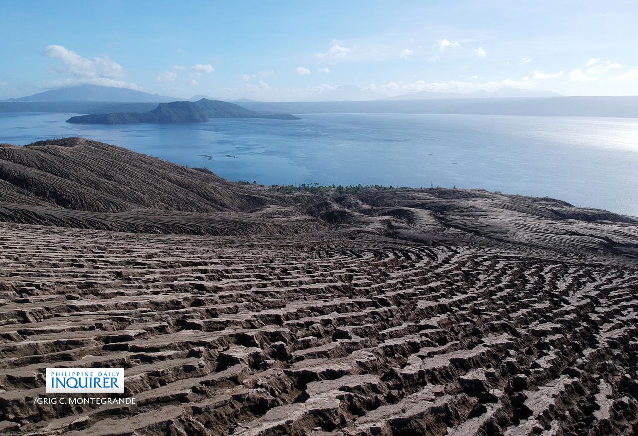
Philippines , Taal :
TAAL VOLCANO BULLETIN 19 January 2021 08:00 A.M.
In the past 24-hour period, the Taal Volcano Network recorded one (1) volcanic earthquake. Emission of white steam-laden plumes from fumarolic activity at Main Crater vents was weak. Ground deformation parameters based on continuous GPS monitoring from 29 March 2020 to present indicated a slow and slight inflation of the northwestern sector of Taal Caldera, which was also recorded by electronic tilt on northwest Volcano Island starting the second week of July 2020. In contrast, GPS data from the southwestern sector of Taal Caldera and Volcano Island yielded no significant change after the huge post-eruption subsidence.
Alert Level 1 (Abnormal) is maintained over Taal Volcano. DOST-PHIVOLCS reminds the public that at Alert Level 1, sudden steam-driven or phreatic explosions, volcanic earthquakes, minor ashfall, and lethal accumulations or expulsions of volcanic gas can occur and threaten areas within the Taal Volcano Island (TVI). DOST-PHIVOLCS strongly recommends that entry into TVI, Taal’s Permanent Danger Zone or PDZ, especially the vicinities of the Main Crater and the Daang Kastila fissure, must remain strictly prohibited. Local government units are advised to continuously assess previously evacuated barangays around Taal Lake for damages and road accessibilities and to strengthen preparedness, contingency, and communication measures in case of renewed unrest. People are also advised to observe precautions due to ground displacement across fissures, possible ashfall, and minor earthquakes. Civil aviation authorities must advise pilots to avoid flying close to the volcano as airborne ash and ballistic fragments from sudden explosions and wind-remobilized ash may pose hazards to aircraft. DOST-PHIVOLCS is closely monitoring Taal Volcano’s activity and any new significant development will be immediately communicated to all stakeholders.
Source : Phivolcs
Photo : Grig C. Montegrande/Philippine Daily Inquirer via Vulcanologia Esia .