October 28 , 2022.
Kamchatka , Bezymianny :
VOLCANO OBSERVATORY NOTICE FOR AVIATION (VONA)
Issued: October 27 , 2022
Volcano: Bezymianny (CAVW #300250)
Current aviation colour code: ORANGE
Previous aviation colour code: yellow
Source: KVERT
Notice Number: 2022-151
Volcano Location: N 55 deg 58 min E 160 deg 35 min
Area: Kamchatka, Russia
Summit Elevation: 2882 m (9452.96 ft)
Volcanic Activity Summary:
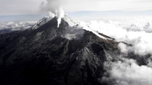
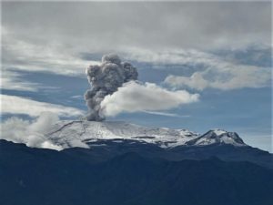
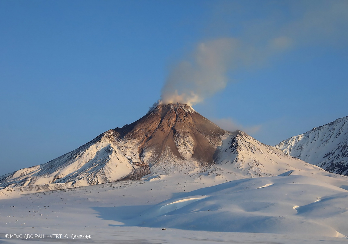
The strong explosive eruption of the volcano occurred on 23-24 October. The extrusive-effusive eruption of the volcano continues, a strong fumarole activity, an incandescence of the lava dome at night, and hot avalanches accompanies this process. Sometimes the large ash clouds were forming after hot avalanches, for example, such ash cloud 10×13 km in size moved for 70 km to the east of the volcano on 26 October. Probably, next strong explosive eruption could occur at any time. KVERT continues to monitor Bezymianny volcano.
The extrusive-effusive eruption of the volcano continues, but the activity of the volcano remains very high. Strong ash explosions up to 10-15 km (32,800-49,200 ft) a.s.l. could occur at any time. Ongoing activity could affect international and low-flying aircraft.
Volcanic cloud height:
NO ASH CLOUD PRODUSED
Other volcanic cloud information:
NO ASH CLOUD PRODUSED
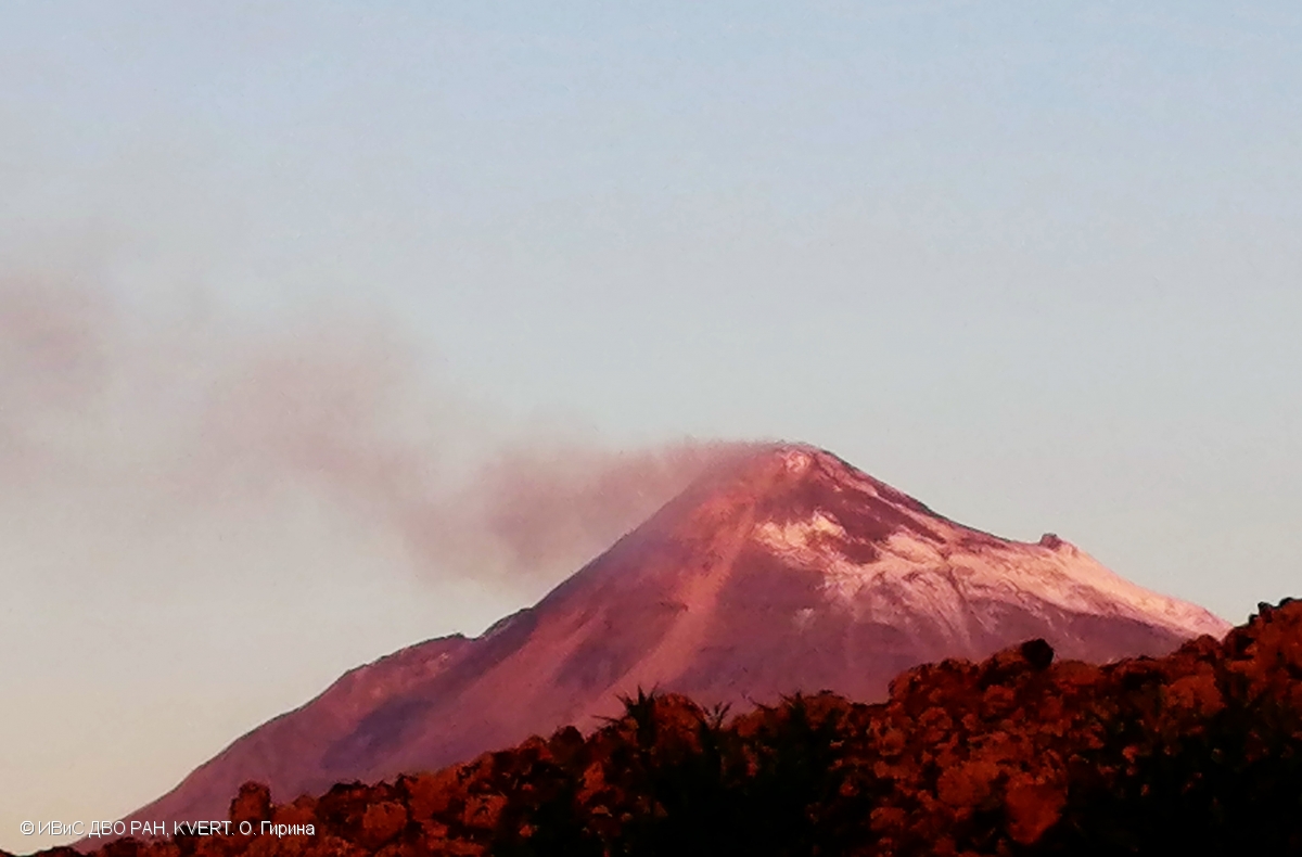
Activity at Bezymianny increased during 22-23 October characterized by incandescence at the summit, sometimes strong fumarolic activity, and an increasing temperature of a thermal anomaly identified in satellite images. KVERT raised the Aviation Color Code to Orange (the second highest level on a four-color scale). A strong explosive phase commenced and by 23h40 local time on 23 October satellite images showed ash plumes rising to 10 km (32,800 ft) a.s.l. and drifting 10 km ENE. The Aviation Color Code was raised to Red. By 10h05 local time on 24 October the phase was over, and the Aviation Color Code was lowered to Orange. Satellite images showed gas-and-steam plumes drifting NE and an intense thermal anomaly. The ash plumes from the day before had drifted as far as 1,915 km NE. At 20h28 local time on 25 October KVERT lowered the Aviation Color Code to Yellow and noted that the intense thermal anomaly persisted. Dates are based on UTC times; specific events are in local time where noted.
Source : Kvert.
Photos : Yu. Demyanchuk, IVS FEB RAS, KVERT , O. Girina, IVS FEB RAS, KVERT
Italy , Vulcano :
WEEKLY BULLETIN, from October 17, 2022 to October 23, 2022, (issue date October 25, 2022).
ACTIVITY STATUS SUMMARY
In the light of the surveillance data, it is highlighted:
1) Temperature of the crater fumaroles: Along the upper edge, the maximum emission temperature has stable and high values, around 375°C.
2) CO2 flux in the crater area: The CO2 flux in the crater area remains at medium-high values.
3) SO2 flux in the crater area: stable at a moderately medium-high level
4) Geochemistry of fumarolic gases: The concentration of CO2 and He is constant or slightly increasing and remains at an average level. The carbon isotope ratio is constant at high values and the helium isotope ratio is stable at medium levels.

5) CO2 fluxes at the base of the La Fossa cone and in the Vulcano Porto area: The CO2 fluxes recorded in the Rimessa, C. Sicilia sites always show values above background levels. The P4max site shows average values, while on the Faraglione site there are values close to the background level.
6) Geochemistry of thermal aquifers: in the well of Camping Sicilia there are always high values of temperature and conductivity at medium-low levels; in the Bambara well, the level and conductivity values show no significant variations.
7) Local seismicity: Low occurrence rate of local micro-seismicity.
8) Regional seismicity: No earthquake with Ml >= 1.0 was located in the Vulcano region last week.
9) Deformations – GNSS: The GNSS network does not show significant variations
10) Deformations – Inclinometry: The inclination network does not show significant variations
11) Gravimetry: There are no significant variations.
12) Other Notes: Mobile GNSS. The GNSS mobile network acquires and transmits movements in real time at a frequency of 1 Hz. The historical series acquired so far do not show significant variations around the Porto di Levante area.
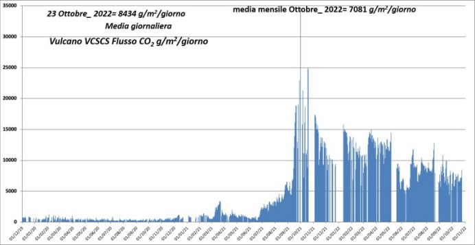
Flux diffus de CO2 du sol dans le site situé à l’Est de la zone fumerolienne (site VSCS).
CO2 FLOW IN THE CRATER AREA
The data from the VSCS station do not show any significant changes in the CO2 flux (approximately 8000 g m2 d-1) compared to the previous week, still settling on abnormal values compared to the average background values assessed on the last decade of observations and monitoring.
Source et photos : INGV.
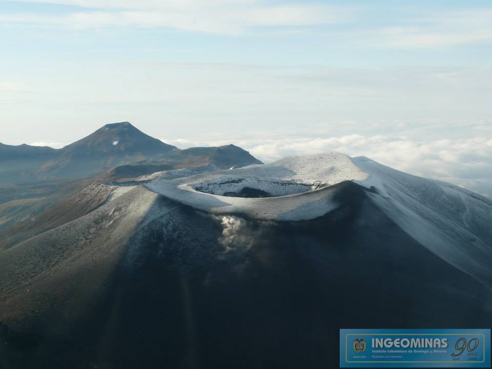
Colombia, Puracé – Los Coconucos volcanic chain:
Weekly bulletin of the activity of the Puracé volcano – Los Coconucos volcanic chain.
The activity level of the volcano continues at the Yellow activity level or (III): changes in the behavior of volcanic activity.
From the analysis and evaluation of the information obtained through the monitoring network of the Puracé volcano – Los Coconucos volcanic chain, during the week of October 18 to 24, 2022, the COLOMBIAN GEOLOGICAL SERVICE – Volcanological and Seismological Observatory of Popayan reports that:
With regard to the seismic activity recorded, there were no notable variations in terms of the number of events and the energy released. A total of 683 seismic events were recorded, of which 74 were associated with rock fracturing processes (VT type) and 609 with fluid dynamics in volcanic conduits. On October 18, a VT type event was recorded which reached an ML of 3.2 located in the Paletará valley, south of the volcanic edifice.
The geodetic network of GNSS (Global Navigation Satellite System) stations for monitoring ground deformation continues to record a process associated with inflation.
By monitoring the surface activity with the images obtained during the week through the web cameras Mina, Lavas Rojas, Cerro Sombrero and Curiquinga, it has been highlighted
degassing of the volcanic system, with a white column oriented preferentially to the northwest.
Regarding the monitoring of volcanic gases, sulfur dioxide (SO2) measurements continue to show changes, with a maximum flow of 246 t / day for the week evaluated. The other instruments measuring the concentration of carbon dioxide (CO2) and radon gas (222Rn) in the volcanic influence zone recorded increases for the period evaluated, which is normal in active volcanic systems.
Magnetic field and infrasonic wave monitoring sensors did not record variations associated with changes in volcanic activity.
It is concluded from the above that variations in volcanic activity continue to be recorded, consistent with the behavior expected at activity level III (yellow level), which could evolve towards states of greater activity. The Colombian Geological Service continues to monitor the evolution of the volcanic phenomenon and will report any changes that may occur in due course.
Source : SGC.
Photo : Ingeominas
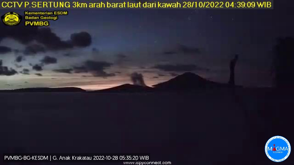
Indonesia , Anak Krakatau :
Anak Krakatau presented an eruption on Friday October 28, 2022 at 04:38 WIB with an ash column height observed at ± 300 m above the summit (± 457 m above sea level). The ash column is observed to be gray with a thick intensity, oriented towards the northeast. This eruption was recorded on a seismograph with a maximum amplitude of 40 mm and a duration of 12 seconds.
VOLCANO OBSERVATORY NOTICE FOR AVIATION – VONA
Issued : October 27 , 2022
Volcano : Anak Krakatau (262000)
Current Aviation Colour Code : ORANGE
Previous Aviation Colour Code : orange
Source : Anak Krakatau Volcano Observatory
Notice Number : 2022KRA82
Volcano Location : S 06 deg 06 min 07 sec E 105 deg 25 min 23 sec
Area : Lampung, Indonesia
Summit Elevation : 502 FT (157 M)
Volcanic Activity Summary :
Eruption with ash clouds at 05:05 UTC (12:05 local time). The eruption lasted for 25 seconds.
Volcanic Cloud Height :
Best estimate of ash-cloud top is around 1302 FT (407 M) above sea level, may be higher than what can be observed clearly. Source of height data: ground observer.
Other Volcanic Cloud Information :
Visuals directly from the cctv were observed eruptions with the color of the grey eruption smoke 250m from the top of the volcano, the wind direction slowly to the northeast.
Remarks :
Eruption recorded on seismogram with maximum amplitude 37 mm and maximum duration 25 second.
Source et photo : Magma Indonésie.
Tonga Islands, Tofua :
The sulphur dioxide gas measured 9,000 ppm (parts per million) on the eve of the 15th October, 2022 on the eastern side of Tofua Volcano. This is an indication that the magma chamber is close to the earth’s surface. The measurement was taken below the volcanic gas plume drifting eastward from Lofia Volcano Cone on Tofua Island.
There are no immediate danger, however, the public is advised to report any peculiar activities activities from the area.
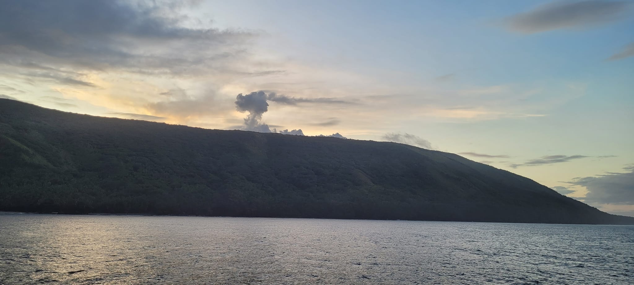
The low, forested Tofua Island in the central part of the Tonga Islands group is the emergent summit of a large stratovolcano that was seen in eruption by Captain Cook in 1774. The summit contains a 5-km-wide caldera whose walls drop steeply about 500 m. Three post-caldera cones were constructed at the northern end of a cold fresh-water caldera lake, whose surface lies only 30 m above sea level. The easternmost cone has three craters and produced young basaltic-andesite lava flows, some of which traveled into the caldera lake. The largest and northernmost of the cones, Lofia, has a steep-sided crater that is 70 m wide and 120 m deep and has been the source of historical eruptions, first reported in the 18th century. The fumarolically active crater of Lofia has a flat floor formed by a ponded lava flow.
Source et photo : Tonga geological service.