October 26 , 2020.
Argentina / Chile , Copahue :
During the period evaluated, the volcano-tectonic (VT) seismicity remained stable compared to the previous period, remaining at values considered low for this volcano.
The highest energy event had a local magnitude (ML) of 1.3 and was located 3.4 km north (N) of the crater at a depth of 2.8 km.
Long period type (LP) seismic activity remained at low levels similar to the previous period, while discrete explosive (EX) activity was not recorded again.
The continuous tremor signal remained at low levels, probably related to a decrease in surface activity in the crater.

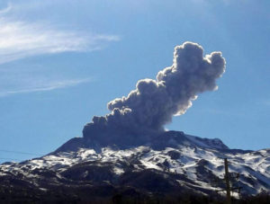
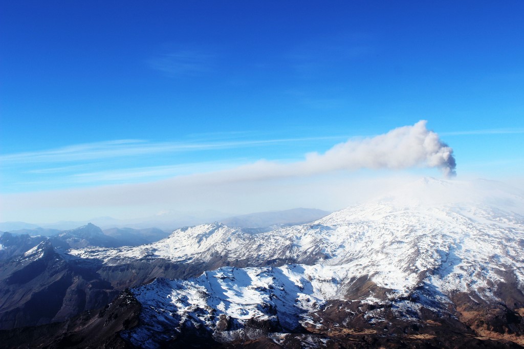
The images provided by the IP cameras made it possible to observe an almost constant degassing column, with almost no particles present. The maximum height recorded was 1420 m above the crater, corresponding to a mainly gaseous emission.
For several nights, it was possible to observe an incandescence. However, it started to decrease over the days.
In total, six (8) satellite anomalies of sulfur dioxide (SO2) emissions were reported for the period.
Two (2) thermal alerts associated with the crater were recorded on October 07 and 12, using Sentinel 2-L2A image processing.
The DOAS SO2 emission measurement stations only operated for 3 days. During this period, the maximum value recorded was 3824 tons / day on October 5, a value considered high for this volcano.
CONCLUSIONS
The Copahue volcano monitoring parameters remain at levels considered low. However, the recording of transient increases in the amplitude of the continuous tremor continues, linked to the emission of particles into the atmosphere and the occurrence of nocturnal incandescence.
This suggests pulsatile activity, linked to the interaction of deep magmatic material with the surface hydrothermal system.
Taking this into account, there is always the probability that the volcanic system could generate new episodes with more energetic emissions of gases and particles, which could affect the sectors close to the crater, and possibly the sectors near the volcano to following the fall of volcanic ash.
Source : Segemar.
Photos : Dario G. Lazo , sernageomin .
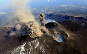
Kamchatka , Karymsky :
VOLCANO OBSERVATORY NOTICE FOR AVIATION (VONA).
Issued: October 26 , 2020
Volcano: Karymsky (CAVW #300130)
Current aviation colour code: ORANGE
Previous aviation colour code: orange
Source: KVERT
Notice Number: 2020-197
Volcano Location: N 54 deg 2 min E 159 deg 26 min
Area: Kamchatka, Russia
Summit Elevation: 4874.08 ft (1486 m)
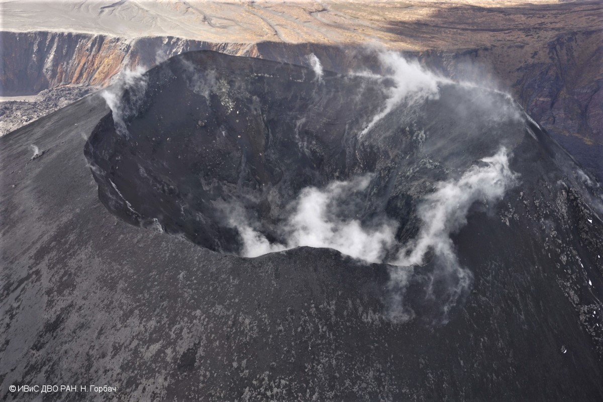
Fumarole activity of Karymsky volcano on 24 September, 2020.
Volcanic Activity Summary:
Satellite data by KVERT showed an ash cloud 12×18 km is drifting about 37 km to the north of the volcano.
A moderate eruptive activity of the volcano continues. Ash explosions up to 19,700-23,000 ft (6-7 km) a.s.l. could occur at any time. Ongoing activity could affect low-flying aircrafts.
Volcanic cloud height:
13120-16400 ft (4000-5000 m) AMSL Time and method of ash plume/cloud height determination: 20201026/0450Z – Himawari-8
Other volcanic cloud information:
Distance of ash plume/cloud of the volcano: 23 mi (37 km)
Direction of drift of ash plume/cloud of the volcano: N / azimuth 1 deg
Time and method of ash plume/cloud determination: 20201026/0450Z – Himawari-8
Start time of explosion and how determined: 20201026/0430Z – Satellite data
Source : Kvert .
Photo : N. Gorbach, IVS FEB RAS.
Guatemala , Fuego :
SPECIAL VOLCANOLOGICAL BULLETIN
UPDATE ON THE EXPLOSIVE ACTIVITY OF VOLCANO FUEGO.
Activity in the crater of the Fuego volcano generates explosions of different characteristics and sizes, with weak to moderate explosions being the most frequent. However, during the month of October, from 1 to 13 explosions of the Vulcanian type were recorded per day, which are accompanied by the emission of abundant incandescent materials, ashes and gases. During the night and early in the morning of October 22, incandescent avalanches could be observed in the direction of the ravines of Las Lajas, Ceniza, Seca and Taniluya, as well as incandescent pulses with a height of up to 300 meters above the crater. . The atmospheric conditions made it possible to observe these avalanches throughout their journey, as well as to listen to the sounds generated by the explosions at distances of up to 25 km.
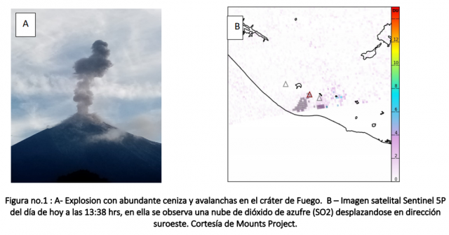
Photo 1 shows the outgassing and ash plume caused by a large explosion, which can reach up to 4800 meters (15,748 feet) in height, causing gases such as SO2 and ash to disperse over long distances (see figure no. 1 B). Acoustic monitoring sensors, used to track explosive activity, indicate that the strongest explosions were recorded on October 16, 20 and 21. However, the days with the most violent explosions were October 16 and 23. During the month of October, a total of 1606 explosions were recorded, and in the last 5 days, 45 loud explosions were recorded. This activity should continue over the next few days or weeks.
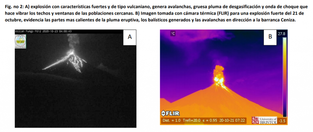
Loud explosions, like those recorded on Thursday, October 22 at night, can generate ballistic falls around the volcanic building, which can impact remote areas, such as the area known as « La Meseta », which is frequently visited by large groups of climbers and tourists. Ballistic projections in this area can reach up to half a meter in diameter and therefore cause burns, bruises or fractures upon impact on any part of the body.
Source : Insivumeh .
Video : Gevolcans.
Mexico , Popocatepetl :
October 25, 11:00 a.m. (October 25, 4:00 p.m. GMT).
During the last 24 hours, according to the monitoring systems of the Popocatépetl volcano, 392 exhalations accompanied by water vapor, volcanic gases and small amounts of ash have been identified. Throughout the day, the emissions dispersed mainly towards the southwest sector. 61 minutes of low amplitude tremor were also recorded.

At the time of this report, a slight continuous emission of water vapor and gas is observed which disperses towards the southwest.
CENAPRED urges NOT TO APPROACH the volcano and especially the crater, because of the danger posed by the fall of ballistic fragments and, in the event of heavy rains, to stay away from the bottom of the ravines because of the danger of lava flows. mud and debris.
The Popocatépetl volcanic alert semaphore is in YELLOW PHASE 2.
Source : Cenapred .
Photo : Webcamdemexico ( archive) .