October 02 , 2020.
La Réunion , Piton de la Fournaise :
Activity bulletin from Thursday, October 1, 2020 at 9:30 a.m. (local time)
Alert level: Alert 1
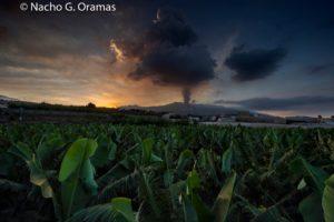
After a decrease in the number of earthquakes, the seismic crisis (in the strict sense of the term), which began on September 28, 2020 at 12:04 p.m. local time, ended around 12:00 p.m. local time on September 30. On the other hand, the seismicity still persists with on average over the last hours, 4 earthquakes or landslides / hour. Given the sharp decrease in the number of earthquakes, the term « seismic crisis » is therefore no longer applicable at the present time.
Between September 28 and September 30 (12 p.m. local time), around 2300 earthquakes (1551 superficial summit volcano-tectonic earthquakes, 472 deep volcano-tectonic earthquakes, 48 long periods, and 217 earthquakes classified as « undetermined » because of low magnitudes) and 543 landslides / superficial collapses were recorded by the OVPF. This seismicity was located under the summit and under the eastern flank of the volcano (between 1.6 and 5.2 km deep; Figure 1).
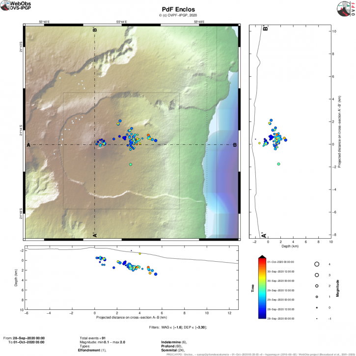
Figure 1: Location map (epicenters) and north-south and east-west sections (showing the location in depth, hypocenters) of the earthquakes recorded and located by the OVPF-IPGP between 28/09/2020 and 01/10 / 2020 (9h00) under the Piton de la Fournaise massif. Only localizable earthquakes have been shown on the map (© OVPF-IPGP).
During the day of 09/30, the deformations continued on the east flank of the volcano, thus the GPS station « GPNG » of the OVPF located in the upper part of the Grandes Pentes, at an altitude of 1414 m, has continued to slide eastward by 10 cm, or about 70 cm in total since the onset of the seizure, and has risen by about 25 cm since the onset of the seizure (Figure 2).
The persistence of seismicity and deformation under the eastern flank shows that the intrusion of magma towards the eastern flank is still active and that an eruption cannot be excluded. The observatory teams remain mobilized.
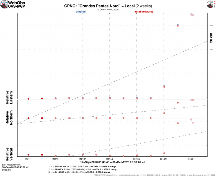
Figure 2: Movements of the GPS station « GPNG » of the OVPF located in the upper part of the Grandes Pentes, at an altitude of 1414 m, on the East-West (top), North-South component (in the middle) and Vertical (bottom) over the past two weeks. In blue the raw data, in red the corrected data of the movement of the plate (© OVPF-IPGP).
Source : OVPF.
Read the article : http://www.ipgp.fr/fr/ovpf/bulletin-dactivite-jeudi-1-octobre-2020-a-9h30-heure-locale
Photo : Nath Duverlie
Italy / Sicily , Etna :
ETNA PRESS RELEASE [UPDATE n. 81], 01 October 2020.
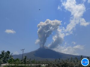
The National Institute of Geophysics and Volcanology, Osservatorio Etneo, reports that the previously communicated increase in explosive activity in the New Southeast Crater occurred between 8:00 a.m. and 9:30 a.m. local time.
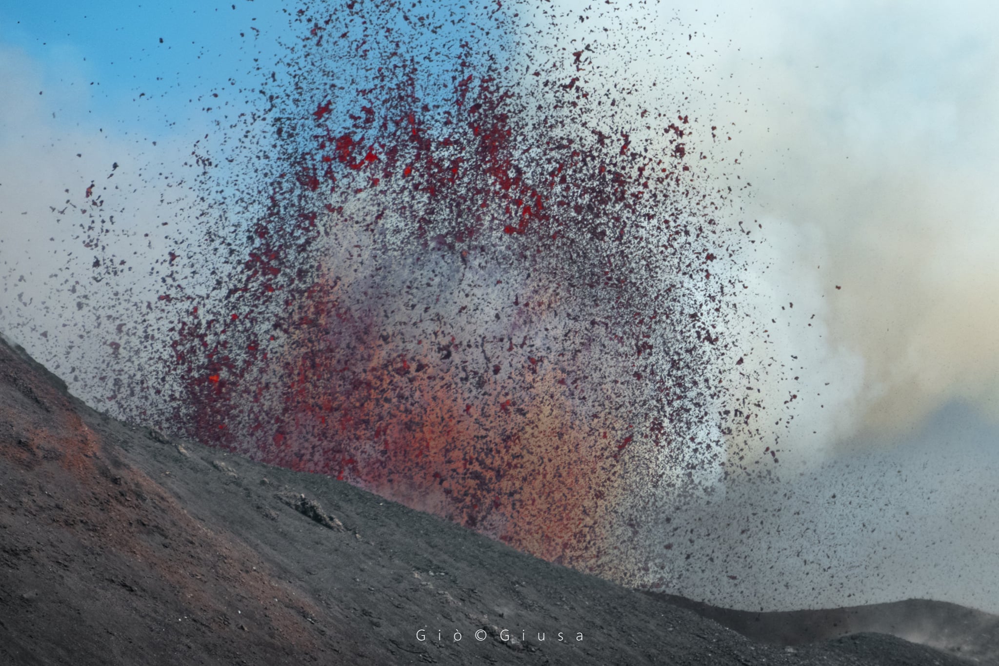
Booooom !!! The mouth of the Saddle of the Southeast Crater
Etna Sud, October 1, 2020
The modest ash emission that produced the eruptive cloud about 4.5 km above sea level has now ceased. Strombolian activity remains, accompanied by discontinuous and weak ash emissions which are rapidly dispersed in the summit area.
The amplitude of the volcanic tremor, in slight increase, shows fluctuations between medium-high levels. Infrasound events associated with ongoing explosive activity are observed.
The Etna soil deformation monitoring networks do not show significant variations.
Further updates will be communicated shortly.
Source : INGV .
Photo : Gio Giusa .
Kamchatka : Klyuchevskoy ,
VOLCANO OBSERVATORY NOTICE FOR AVIATION (VONA).
Issued: October 02 , 2020
Volcano: Klyuchevskoy (CAVW #300260)
Current aviation colour code: YELLOW
Previous aviation colour code: green
Source: KVERT
Notice Number: 2020-181
Volcano Location: N 56 deg 3 min E 160 deg 38 min
Area: Kamchatka, Russia
Summit Elevation: 15580 ft (4750 m)
Volcanic Activity Summary:
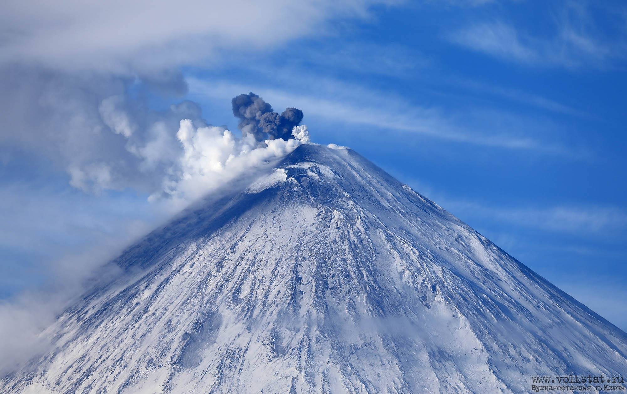
According to video data, the Strombolian activity of Klyuchevskoy volcano began to observing from 22:03 UTC on 01 October, 2020, and such activity continues. Explosions send ash up to 300-400 m above the crater of the volcano (about 5 km a.s.l.), a gas-steam plume containing some amount of ash descends along the slope of the volcano towards the east. An ash plume is not detect on the satellite images at this time.
A moderate explosive eruption of the volcano possibly will continues. Ash explosions up to 16,400-19,700 ft (5-6 km) a.s.l. could occur at any time. Ongoing activity could affect low-flying aircraft.
Volcanic cloud height:
16400 ft (5000 m) AMSL Time and method of ash plume/cloud height determination: 20201002/0038Z – Video data
Other volcanic cloud information:
Distance of ash plume/cloud of the volcano: 6 mi (10 km)
Direction of drift of ash plume/cloud of the volcano: E
Time and method of ash plume/cloud determination: 20201002/0038Z – Video data
Source : Kvert.
Photo : Volkstat ru
Hawaii , Mauna Loa :
19°28’30 » N 155°36’29 » W,
Summit Elevation 13681 ft (4170 m)
Current Volcano Alert Level: ADVISORY
Current Aviation Color Code: YELLOW
Activity Summary:
Mauna Loa Volcano is not erupting. Rates of deformation and seismicity have not changed significantly over the past week and remain above long-term background levels.
Observations:
During the past week, HVO seismometers recorded approximately 115 small-magnitude (below M2.5) earthquakes on the volcano’s summit and upper-elevation flanks. The majority of these earthquakes occurred at shallow depths of less than 8 kilometers (~5 miles) below sea level.
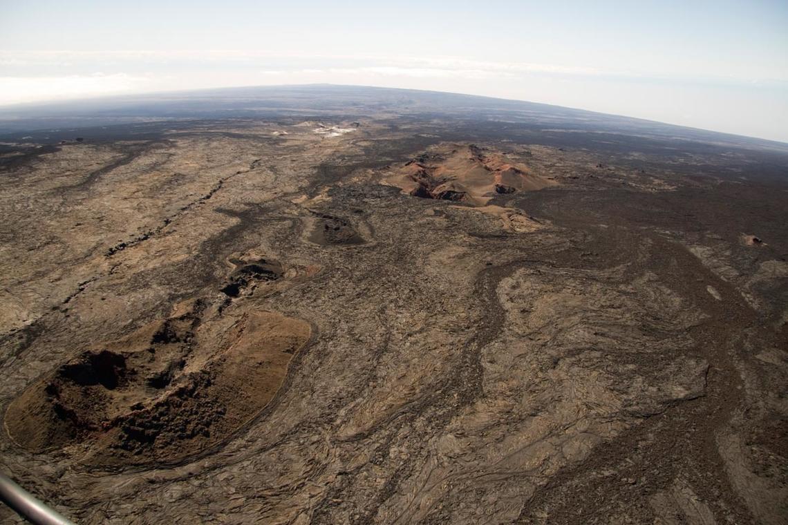
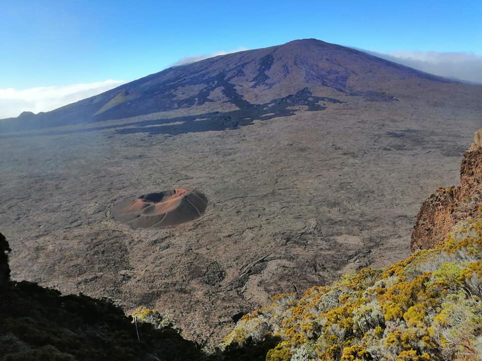
View from just below the summit of Mauna Loa looking back down the Southwest Rift. The Sulfur Cone is the white area just above center frame. Pu‘u o Keokeo is the barely visible bump just above Sulfur Cone at the crest of the Southwest Rift .
Global Positioning System (GPS) measurements continue to indicate slow, long-term summit inflation, consistent with magma supply to the volcano’s shallow storage system.
Gas concentrations and fumarole temperatures at both the summit and Sulphur Cone on the Southwest Rift Zone remain stable.
Webcam views have revealed no changes to the landscape over the past week.
Source : HVO.
Mexico , Popocatepetl :
October 01, 11:00 a.m. (October 01, 4:00 p.m. GMT)
During the last 24 hours, the Popocatépetl volcano monitoring system has identified 70 exhalations accompanied by volcanic gases and sometimes slight amounts of ash. In addition, 444 minutes of tremor and three volcano-tectonic earthquakes were recorded: the first two recorded yesterday at 10:14 p.m. and 11:27 p.m., the rest today at 4:05 a.m., with a calculated magnitude of 2, 2, 1.8 and 1.8 respectively.
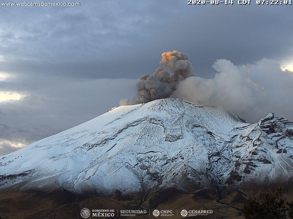
As of today morning and at the time of this report, emissions of water vapor, gas and ash have been observed in a westerly direction.
CENAPRED urges not to approach the volcano and in particular the crater, because of the danger posed by the fall of ballistic fragments and, in the event of heavy rains, to stay away from the bottom of the ravines because of the danger of mudslides and debris.
The Popocatépetl volcanic alert semaphore is on YELLOW PHASE 2.
Source : Cenapred
Photo : Archive webcamdemexico.