September 15 , 2020.
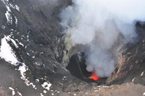
Alaska , Katmai :
58°16’44 » N 154°57’12 » W,
Summit Elevation : 6716 ft (2047 m)
Current Volcano Alert Level: NORMAL
Current Aviation Color Code: GREEN
Strong southerly winds in the vicinity of Katmai and the Valley of Ten Thousand Smokes have picked up loose volcanic ash erupted during the 1912 Novarupta-Katmai eruption and carried it to the north today. The resuspended ash cloud was observed by a local pilot flying in the vicinity of Brooks Camp and Naknek Lake on the Alaska Peninsula at ~18:25 AKDT (15 September at 02:25 UTC) and is ongoing. The resuspended ash cloud height is unknown but the National Weather Service suggests that it could be up to 4,000 ft above sea level. Cloudy conditions have prevented observations by satellite.
Mt Griggs on the left, Mt. Trident on the right as seen from Katmai Pass, Katmai National Park and Preserve. Prominent dark lava flows are from Trident’s 1953 – 1974 eruption.
This phenomenon is not the result of recent volcanic activity and occurs during times of high winds and dry snow-free conditions in the Katmai area and other young volcanic areas of Alaska. No eruption is in progress. All of the volcanoes of the Katmai area (Snowy, Griggs, Katmai, Novarupta, Trident, Mageik, Martin) remain at color code GREEN.
Resuspended volcanic ash should be considered hazardous and could be damaging to aircraft and health.
Source : AVO.
Photo : Cyrus Read ( 2009) .
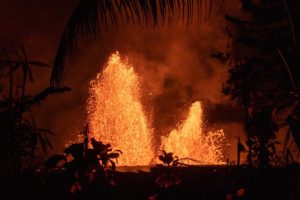
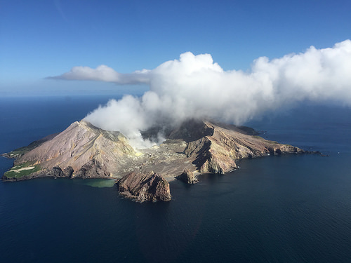
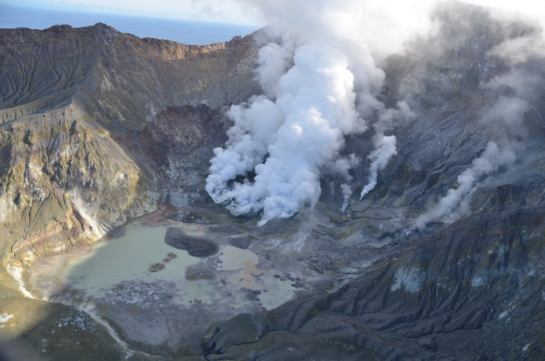
New Zealand , White Island :
Whakaari/White Island: Activity update. Minor volcanic unrest continues.
Volcanic Alert Level remains at 1
Aviation Colour Code remains at Green
New observations since July show continued but relatively low levels of volcanic activity at Whakaari/White Island. The Volcanic Alert Level remains at 1.
Over the last 6 weeks we have conducted three gas flights and one observation flight. Results from the gas flights indicate that magma beneath the volcano still degasses at fairly high rates. The vent system above the magma appears to be open, allowing the gas to escape relatively unobstructed. During fine weather conditions this will generate moderate to large gas-steam plumes above the island.
Thermal infrared images from the active vent area, taken during the observation flight, remain high at around 440 °C, about 100 °C less than those measured in July. Within the measurement uncertainty, this is consistent with a slowly cooling active vent area. Some of the primary gas vents continue to slowly enlarge. Rainfall events have ponded water on the crater floor forming a lakelet. Minor areas of gassing and heating can be seen in the lakelet.
Ground deformation data from satellite measurements over the past 6 weeks indicate continued subsidence around the active vent area as well as ongoing subsidence of the Main Crater wall, south and west of the 2019 active vents.
The level of volcanic seismic tremor has remained generally low, aside from a short episode of moderate volcanic tremor in early August.
Although current indications are that activity is generally decreasing, an eruption could still occur with little or no warning. The main plausible triggers for a sudden eruption remain the collapse of unstable material from the crater walls onto the vents, increased release of gas from the shallow magma, and the ingress of water underground onto the shallow magma body.
Overall, recent observations are consistent with minor volcanic unrest and, therefore, the Volcanic Alert Level remains at 1 and the Aviation Colour Code remains at Green.
The Volcanic Alert Level reflects the current level of volcanic unrest or activity and is not a forecast of future activity.
Volcanic Alert Level 1 indicates the primary hazards are those expected during volcanic unrest; steam discharge, volcanic gas, earthquakes, landslides and hydrothermal activity. While Volcano Alert Level 1 is mostly associated with environmental hazards, eruptions can still occur with little or no warning.
GNS Science and our National Geohazards Monitoring Centre continue to continuously closely monitor Whakaari/White Island for changes in activity. Further updates will be provided as needed.
Source : Geonet / Yannik Behr (Duty Volcanologist).
Photos : mynewzealand.co.nz , Geonet.
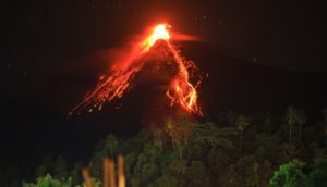
Peru , Sabancaya :
Analysis period: September 7 to 13, 2020, Arequipa, September 14, 2020
Alert level: ORANGE
The Geophysical Institute of Peru (IGP) reports that the eruptive activity of the Sabancaya volcano remains at moderate levels; that is, with the continuous recording of explosions with columns of gas and ash which rises up to 3.5 km above the summit of the volcano. Therefore, for the following days, no significant change is expected regarding its eruptive activity.
The IGP recorded and analyzed the occurrence of 2,024 volcanic earthquakes associated with the circulation of magmatic fluids on the Sabancaya. An average of 38 explosions was recorded daily of low to medium intensity.
During this period, the Volcano-Tectonic (VT) earthquakes presented magnitudes between M2.1 and M3.3 and were located mainly in the North-West area of Sabancaya. The representative earthquake (M3.3) was recorded on September 9 at 5.13 a.m., 13 km northwest of Sabancaya and at a depth of 10 km.

Monitoring the deformation of the volcanic structure, using GNSS equipment and data (processed with fast orbits), recorded a slight inflation of the south-eastern flank of the Sabancaya volcano and the northern sector of Hualca Hualca.
Visual surveillance identified columns of gas and ash up to 3.5 km high above the summit of the volcano, which were scattered towards the southern, southeast and eastern sectors of Sabancaya. Satellite monitoring has identified the presence of 10 thermal anomalies with values between 2 MW and 22 MW, associated with the presence of a lava body (dome) on the surface of the volcano’s crater.
RECOMMENDATIONS
• Maintain the orange volcanic alert level.
• Do not approach within a radius of less than 12 km from the crater.
Source : IGP.
Photo : Andina .
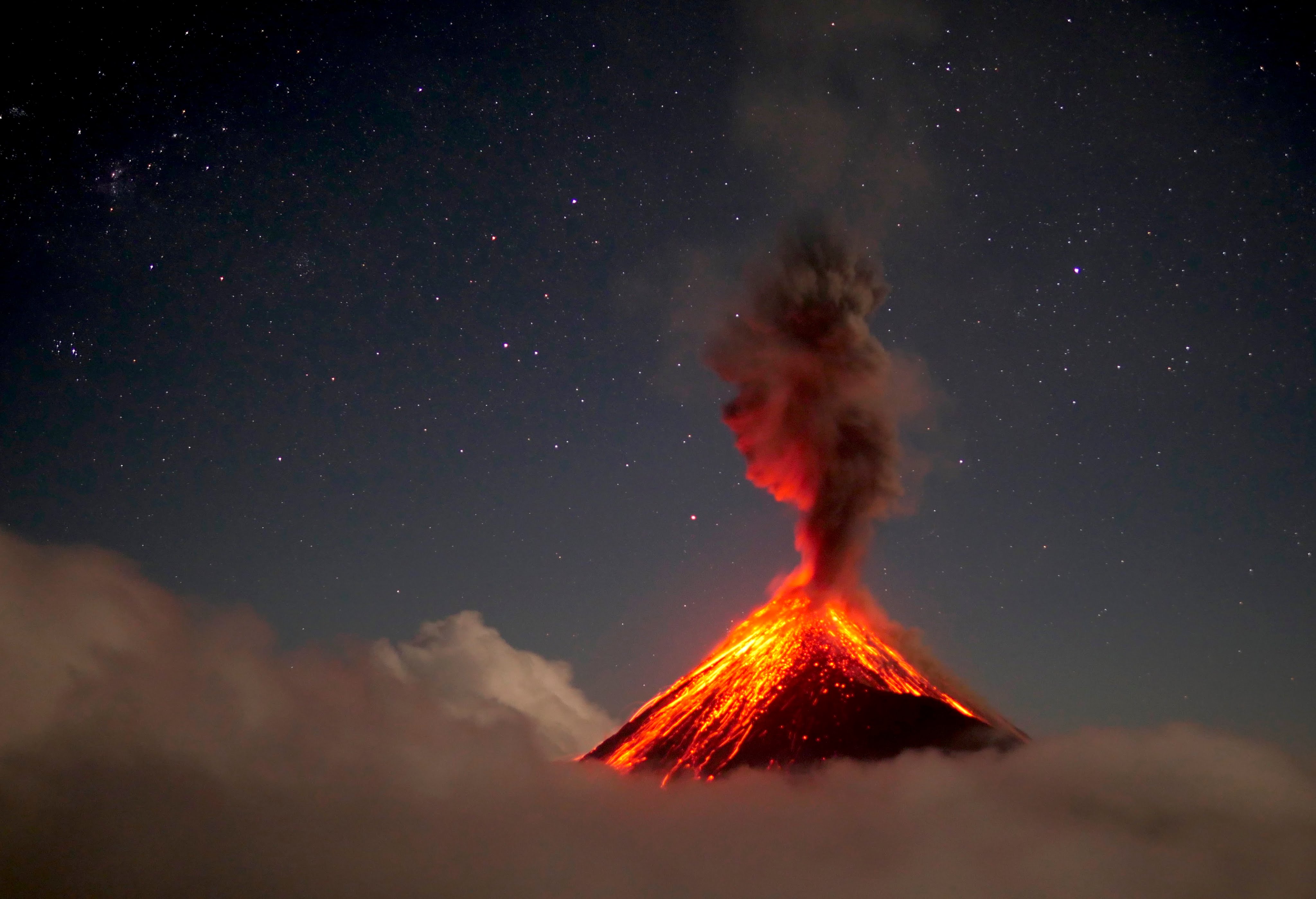
Guatemala , Fuego :
Activity type: Vulcanian
Morphology: composite stratovolcano
Geographical location: 14 ° 28’54˝ Latitude N; 90 ° 52’54˝ Longitude W
Height: 3763 meters above sea level.
Weather conditions: Partly cloudy
Wind: northeast
Precipitation: 100.58 mm.
Activity:
The Fuego Volcano Observatory reports that the approximately 200-meter-long lava flow continues into the Ceniza Canyon, forming boulder avalanches. Weak to moderate explosions were maintained, in a range of 7 to 12 per hour, which are accompanied by columns of gray ash, reaching heights between 4500 and 4800 (14,764 to 15,748 feet) which disperse in a westerly direction and Southwest over a distance of between 15 and 20 kilometers. At night and early in the morning, incandescent pulses were observed at 250 and 300 meters above the crater. A weak white fumarole was observed reaching an elevation of about 4,500 meters (14,764 feet). Avalanches are moderate to strong towards the Seca, Taniluyá, Ceniza, Lajas and Honda ravines with boulders reaching the vegetation. The explosions generate low, moderate to loud rumblings; with weak to moderate shock waves that vibrate the roofs and windows of towns nearly 20 kilometers from the volcanic perimeter. Low noises similar to that of a train locomotive are heard with intervals of 2 to 5 minutes. The fall of ash particles is reported in the villages of Panimaché I, Morelia, Santa Sofía, Finca Palo Verde, Sangre de Cristo, Yepocapa and others. (The recommendations of the special bulletin 69-2020 remain)
Source : Insivumeh .
Photo : 660citynews.com