June 03 , 2020.
Peru , Ubinas :
Analysis period: May 25 to 31, 2020. Arequipa, June 1, 2020.
Alert level: ORANGE Suggested alert level: GREEN
The Geophysical Institute of Peru (IGP) reports that currently the dynamic behavior of the Ubinas volcano (Moquegua region) remains at low levels. Consequently, in the short term, no eruptive activity is planned for the said volcano, so that the population can exercise its activities normally according to the directives of the government and the state of health emergency.
Between May 25 and May 31, the IGP recorded and analyzed a total of 49 seismic events associated with the dynamic behavior of the Ubinas volcano, with the predominance of seismic signals of the Volcano-Tectonic (VT) type, related to the fracturing of rocks inside the volcano. On average, 6 daily earthquakes of very small magnitude were recorded, less than M1.6. The surveillance cameras recorded light and sporadic fumarolic emissions with a water vapor content, which had heights of less than 500 m above the summit of the volcano. The monitoring of the deformation of the volcanic structure does not record any significant anomalies. MIROVA satellite monitoring did not record any thermal anomalies.
RECOMMENDATIONS
• It is recommended to decrease the level of volcanic alert from orange to green.
• Do not approach within a radius of less than 3 km from the volcano crater.
• Do not neglect preventive actions in the event of a possible increase in volcanic activity.
Source : IGP Pérou .
Photo : Unknown author.
Alaska , Cleveland :
AVO/USGS Volcanic Activity Notice
Current Volcano Alert Level: WATCH
Previous Volcano Alert Level: UNASSIGNED
Current Aviation Color Code: ORANGE
Previous Aviation Color Code: UNASSIGNED
Issued: Monday, June 1, 2020, 11:46 PM AKDT
Source: Alaska Volcano Observatory
Location: N 52 deg 49 min W 169 deg 56 min
Elevation: 5676 ft (1730 m)
Area: Aleutians
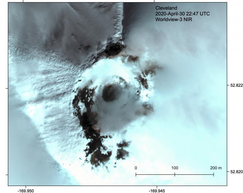
Clear Worldview-3 satellite image of the Cleveland summit crater and lava dome, April 30, 2020. Digital Globe image via NextView License.
Volcanic Activity Summary:
Regional infrasound sensors recorded a small explosion today at about 06:32 UTC (10:32 AKST). No other significant activity was detected and local monitoring stations are offline. A small ash plume was observed at 22,000 ft drifting to the south.
Explosions from Cleveland typically produce relatively small volcanic ash clouds that dissipate within hours; however, more significant ash emissions are possible.
Cleveland volcano is monitored with a limited real-time seismic network, which inhibits AVO’s ability to detect precursory unrest that may lead to an explosive eruption. Rapid detection of an ash-producing eruption may be possible using a combination of seismic, infrasound, lightning, and satellite data.
Recent Observations:
[Volcanic cloud height] 22,000 ft
[Other volcanic cloud information] Drifting to the south
Source : AVO.
Photo : Loewen, Matt .
Guatemala , Fuego :
Special volcanological bulletin
June 2, 2020, 12:51 p.m. local time.
Type of activity: Vulcanian
Morphology: composite stratovolcano
Location: 14 ° 28’54˝Latitude N; 90 ° 52’54˝Longitude W.
Height: 3763 m above sea level.
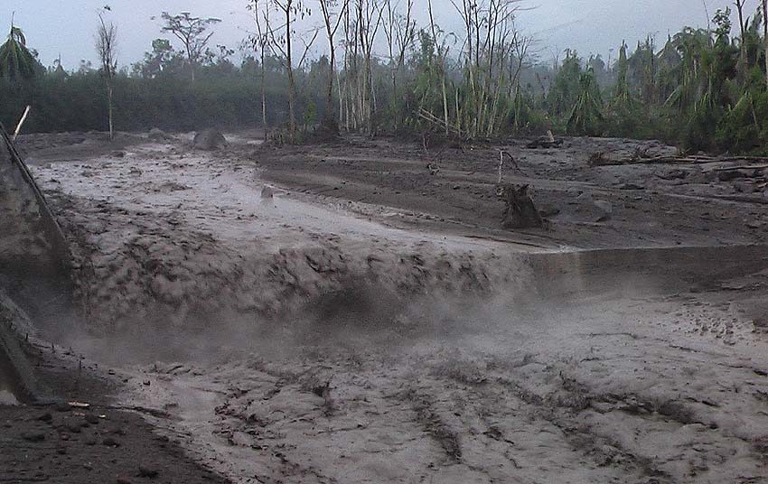
LAHAR IN THE LAS LAJAS RAVINE
The descent of the weak to moderate lahars was reported at 10.50 a.m. (local time) in the Las Lajas ravine, a tributary of the Guacalate river, located southeast of the volcano.
The INSIVUMEH seismic network located on the Fuego Volcano records high frequency seismic tremors. Heavy rains in the upper part of the ravines of the volcanic complex generate the descent of weak to moderate lahars, these can transport branches of trees and volcanic materials such as ashes and blocks of 1 to 2 meters in diameter which make the ground vibrate. If the rain persists, the generation of more lahars in this or other ravines of the volcanic complex is not excluded.
Source : Insivumeh / Fredy Arnoldo Esquit Chiquitá .
Photos : Caroline Sarrazin / Rés-EAUx . Insivumeh.
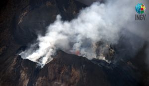
Colombia , Galeras :
Galeras Volcano weekly activity bulletin.
The activity of the volcano continues at the YELLOW LEVEL ■ (III): CHANGES IN THE BEHAVIOR OF VOLCANIC ACTIVITY.
According to the monitoring of the activity of the GALERAS volcano, the COLOMBIAN GEOLOGICAL SERVICE (SGC) reports that:
For the period evaluated between May 26 and June 1, 2020, low levels of seismicity were maintained, both in occurrence and in released seismic energy. We note the predominant events associated with the fracture of solid materials in the volcanic system. This seismicity was localized dispersed around the volcanic building, preferably in the North-East of this one, with epicentral distances going up to 15 km from the active cone, depths lower than 12 km compared to its top (4200 m altitude) and local magnitudes up to 2.9 on the Richter scale.

The most significant volcano-tectonic event was recorded on May 30 at 11:03 p.m., about 8 km southeast of the main crater, with a depth of 10 km below the summit, reported to be felt by residents. of the municipalities of Pasto, Yacuanquer, Tangua and Consacá in the department of Nariño.
The favorable weather conditions from May 27 to 29 made it possible to record gas emissions from the main crater and the fumarole fields on the periphery of the active cone, Las Chavas to the West and El Paisita to the North, with small white columns , very low and stretched by the action of the wind. The other geophysical and geochemical monitoring parameters of the Galeras volcano did not show significant changes.
Source : Ingeominas.
Photo : capra.
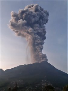
Costa Rica , Rincon de la Vieja :
Activity report of the Rincón de la Vieja volcano, June 02, 2020.
On June 02, 2020 at 2:46 pm local time, an eruption was recorded on the Rincón de la Vieja volcano, with a column which rose to 1000 meters above the height of the crater and to 2916 meters above from sea level. (9564.48 ft).
Duration of activity: 1 minute.
Ash falls reported in: not reported
Sulfur odor reported in: not reported.
https://www.facebook.com/OVSICORI/videos/195870614901145/
Seismic activity is similar to that of yesterday.
The wind direction is unknown at this time.
The volcano has a fairly regular banded tremor (~ 4 episodes per hour), and slightly more frequent between 4 p.m. yesterday and 3 a.m. this morning (~ 5 episodes per hour). Tremors are often associated with a gas pulse, but not systematically. Due to the lack of wind, in the event of an eruption, the damage could be located in any direction around the volcano.
Source : Ovsicori