March 15 , 2020.
Alaska , Shishaldin :
VOLCANO OBSERVATORY NOTICE FOR AVIATION (VONA) .
Issued: (20200315/0631Z)
Volcano: Shishaldin (VNUM #311360)
Current Color Code: ORANGE
Previous Color Code: YELLOW
Source: Alaska Volcano Observatory
Volcano Location: N 54 deg 45 min W 163 deg 58 min
Area: Aleutians
Summit Elevation: 9373 ft (2857 m)
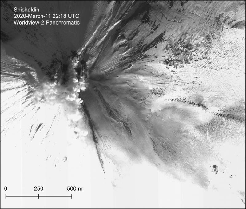
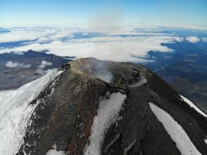
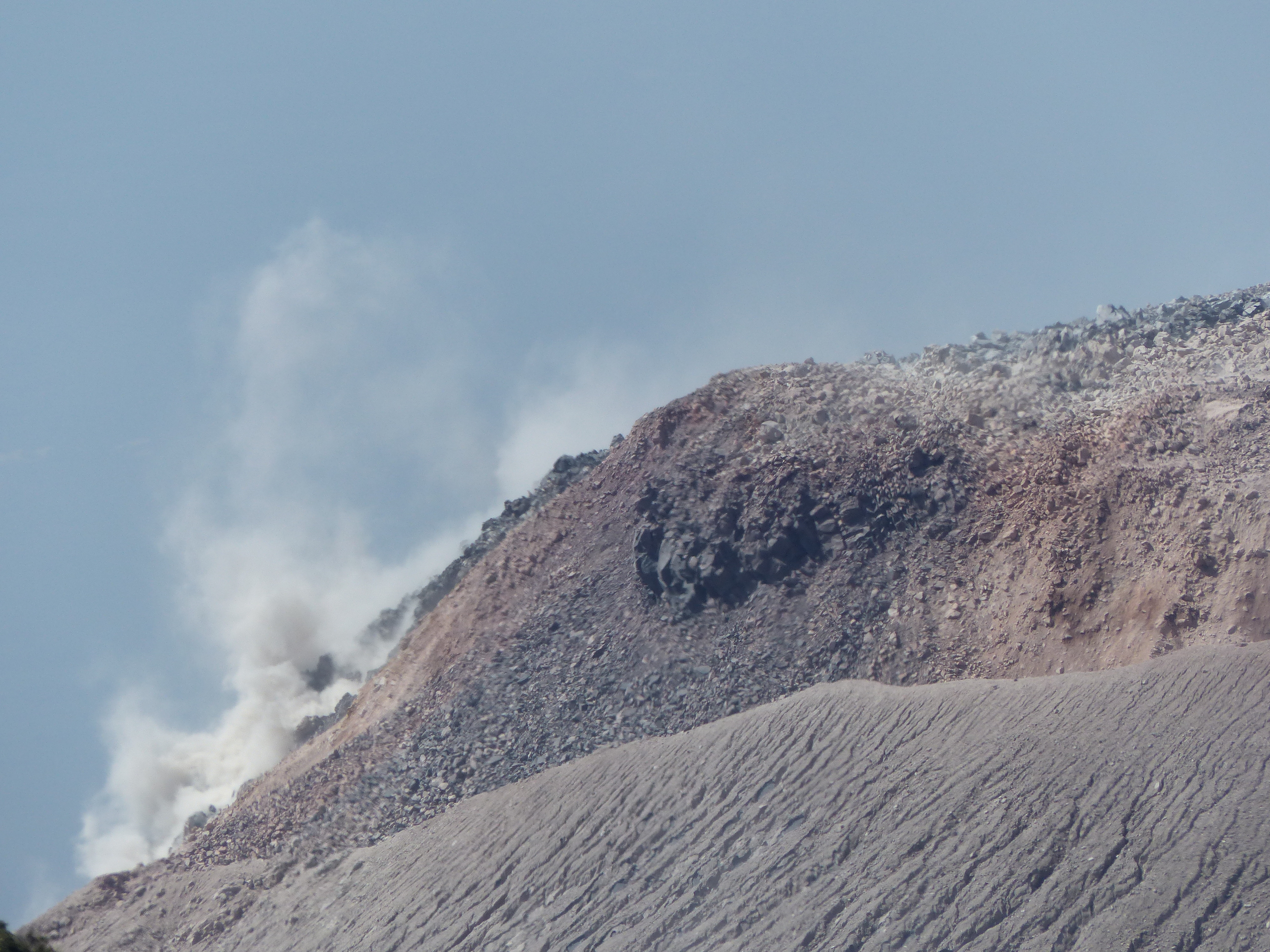
Panchromatic Worldview-2 image of the Shishaldin summit and SE flank with steaming at the summit and a dusting of ash on the flank. There were no indications of lava at the surface by the vent in near-IR image bands (not shown).
Volcanic Activity Summary:
A high-resolution satellite image today shows lava and what appears to be a new cone within the Shishaldin summit crater. Weak seismic tremor has also been detected. Therefore the Aviation Color Code for Shishaldin Volcano is being raised to ORANGE and the Alert Level to WATCH.
No significant ash or lava signatures are apparent outside the summit crater at this time. Eruptive activity could increase with little or no warning resulting in lava flows outside of the crater, lahars, and low-level ash clouds. During the current eruptive cycle, larger ash clouds have also been produced.
Shishaldin is monitored by local seismic and infrasound sensors, satellite data, a web camera, a telemetered geodetic network, and distant infrasound and lightning networks.
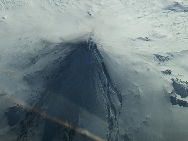
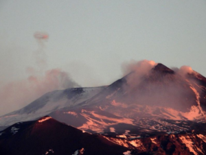
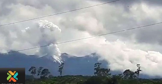
Oblique aerial photo of Shishaldin Volcano taken on March 11, 2020 on and Alaska Airlines flight from Adak to Anchorage, Alaska. Minor steaming from the summit crater is seen. Erosion of the snow and ice on the upper flanks or the volcano can be seen and is the result of lava flows from eruptive activity in late 2019 to early 2020.
Volcanic cloud height: na
Other volcanic cloud information: na
Remarks:
Shishaldin volcano, located near the center of Unimak Island in the eastern Aleutian Islands, is a spectacular symmetric cone with a base diameter of approximately 16 km (10 mi). A 200-m-wide (660 ft) funnel-shaped summit crater typically emits a steam plume and occasional small amounts of ash. Shishaldin is one of the most active volcanoes in the Aleutian volcanic arc, with at least 54 episodes of unrest including over 24 confirmed eruptions since 1775. Most eruptions are relatively small, although the April-May 1999 event generated an ash column that reached 45,000 ft above sea level.
Source : AVO
Photos : Loewen, Matt , Fischer, Ed .
Indonesia , Kerinci :
VOLCANO OBSERVATORY NOTICE FOR AVIATION – VONA.
Issued: 20200314/0933Z
Volcano: Kerinci (261170)
Current Aviation Colour Code: YELLOW
Previous Aviation Colour Code: yellow
Source: Kerinci Volcano Observatory
Notice Number: 2020KER12
Volcano Location: S 01 deg 41 min 49 sec E 101 deg 15 min 50 sec
Area: Jambi, West Sumatra, Indonesia
Summit Elevation: 12176 FT (3805 M)
Volcanic Activity Summary:
On 14 Maret 2020, observed brown ash emission at 09:33 UTC ( 16:33 Local Time )
Volcanic Cloud Height:
Best estimate of ash-cloud top is around 13776 FT (4305 M) above sea level, may be higher than what can be observed clearly. Source of height data: ground observer.
Other Volcanic Cloud Information:
Ash emission moving West – Northwest.
Remarks:
Seismic activity is dominated by gas emission and continuous vulcanic tremor with amplitude 0,5-1 mm (dominan 1mm).
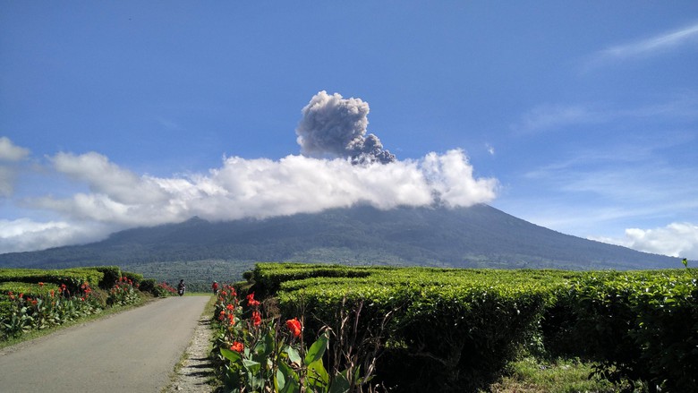
Level of activity at level II (WASPADA). G. Kerinci (3,805 m above sea level) experiences a continuous eruption. The last eruption occurred on March 30, 2019, resulting in an eruption column height of 600 m. The color of the column was observed in gray.
The volcano is clearly visible until it is covered with fog. The smoke from the crater is brown with a strong intensity and rises about 500 meters above the summit. The weather is sunny to cloudy, moderate winds to the west and northwest.
The seismographs of March 14, 2020 recorded:
100 emission earthquakes.
Continuous tremor, amplitude 0.5 to 1 mm (dominant value 1 mm)
Recommendation:
Communities around Mount Kerinci and visitors / tourists are not allowed to climb to the crater at the top of Kerinci volcano within 3 km around the active crater (people are prohibited from doing activities within the danger radius / KRB III).
We recommend avoiding flight paths around G. Kerinci because at any time, there may still be ash eruptions at an altitude that can disrupt the flight path.
Source : Magma Indonesia , PVMBG.
Photo : news detik.com.
Costa Rica , Turrialba / Poas , Rincon de la Vieja / Irazu :
Weekly bulletin from the volcanic monitoring program.
Turrialba volcano
Lat: 10.025 ° N; Long: 83,767 ° W.
Height: 3340 m above sea level
Current activity level: 2 (active volcano)
Potentially associated hazards: gas, ash emission, proximal ballistic emissions.
No ash emission was detected. Landslides have been reported, but the associated signal is within the seismic noise level. The seismicity was maintained with a stable number of LP type events. A contraction of the volcanic building is observed with geodetic measurements. The CO 2 / SO 2 and H 2 S / SO 2 ratios remain stable despite a slight increase in CO 2 / SO 2 over the past week. The flow of SO 2 remains low (<300 t / d).
Poás Volcano
Lat: 10.2 ° N; Long: 84 233 ° W.
Height: 2780 m above sea level
Current activity level: 3 (active volcano)
Potentially associated hazards: gas, ash emission, groundwater eruptions, proximal ballistic emissions.
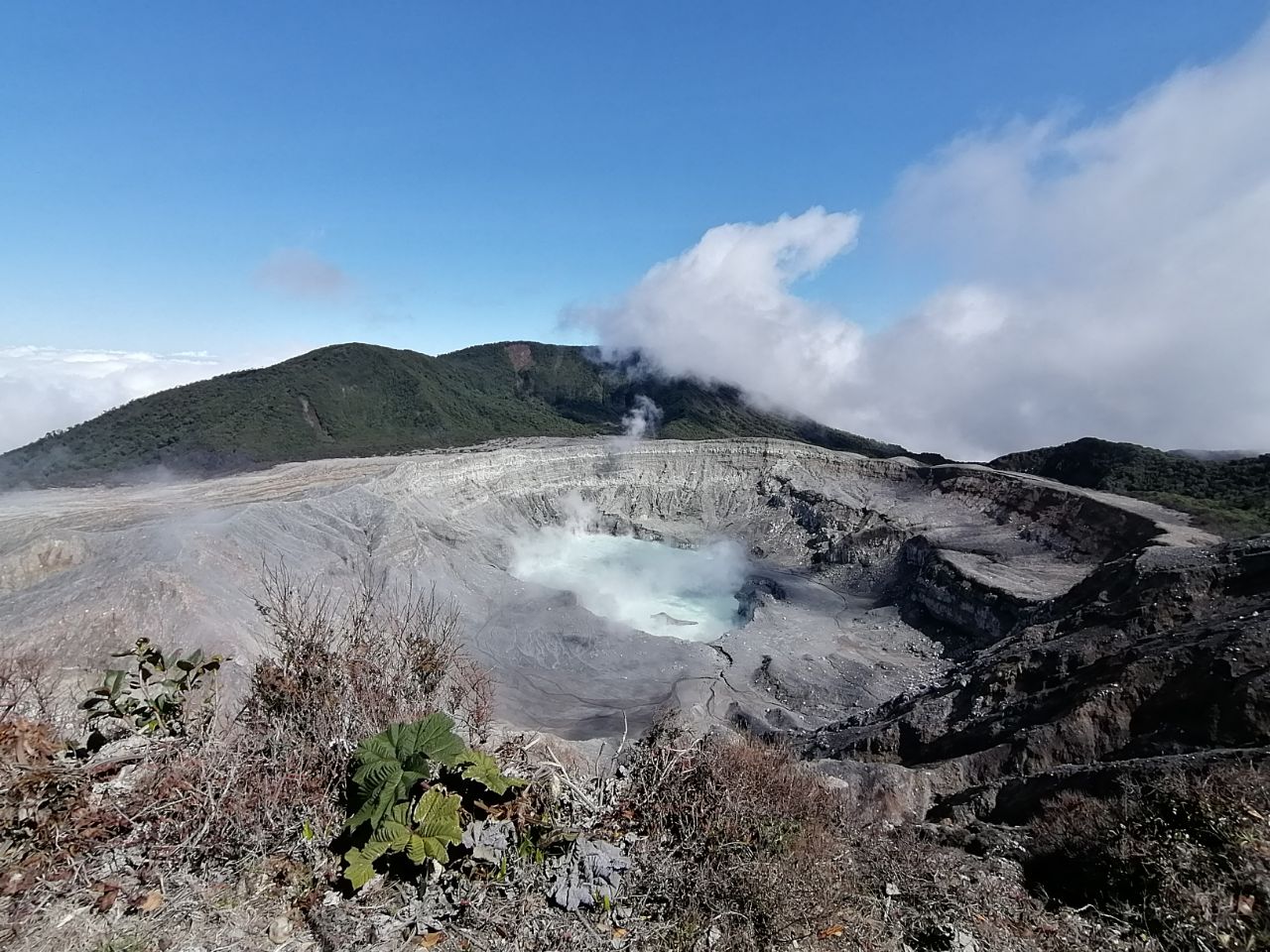
Seismic activity maintains a pattern of variations in the number of LP type events. VT-type events and a daily tremor of very low amplitude were recorded. The deformation measured by geodetic stations is stable. The CO 2 / SO 2 and H 2 S / SO 2 ratios continue to fluctuate with a general upward trend but not yet reaching a critical value. The flow of SO 2 remains stable (around 300 t / d). There were no high values for SO 2 concentrations at the vantage point this week. The lake continues with high concentrations of chloride compared to sulphate (Cl – / SO 4 2- = 1.6).
Rincon de la Vieja volcano
Lat: 10.83 ° N; Long: 85.324 ° W;
Height: 1895 m above sea level
Current activity level: 3 (erupting volcano)
Potentially associated hazards: gas, phreatic eruptions, proximal ballistic emissions, lahars.
No rash was detected. The number of short tremors has increased due to signal segmentation. Consequently, the number of LP type events has decreased. Certain VT type events have been recorded. A slight extension and a small elevation of the summit are observed with geodetic measurements.
Activity report of the Rincón de la Vieja volcano, March 14, 2020.
On March 14, 2020 at 6:45 pm local time, an eruption was recorded on the Rincón de la Vieja volcano, the height reached by the column is unknown due to the visibility conditions of the site.
Duration of the activity: in progress.
Irazú volcano
Lat: 9.979 ° N; Long: 83.852 ° W;
Altitude: 3432 m above sea level
Current activity level: 1 (active)
Potentially associated hazards: landslides.
Small landslides were detected in the crater. GPS measurements show a stable acceleration of landslides in the antenna sector.
Source : Ovsicori.
Photos : Dr Paulo ruiz , RSN , Teletica .
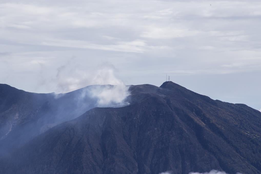
Guatemala , Santiaguito :
Activity type: Pelean
Morphology: Complex of dacitic domes
Location: 14 ° 44 ’33 ˝ Latitude N; 91 ° 34’13˝ W longitude.
Height: 2500 m above sea level.
Weather conditions: Cloudy
Wind: Northeast
Precipitation: 0.0 mm.
Activity:
The volcano maintains the same eruptive pattern as in recent weeks, with white fumaroles observed in the crater of the Caliente dome, mainly water vapor at an altitude of 3200 meters above sea level. The seismic station STG3 reports mainly weak explosions accompanied by ash at an altitude of about 3300 meters (10,826 feet) moving west, above the villages of Loma Linda and San Marcos Palajunoj. Some explosions generate airplane turbine noises due to the pressure of magmatic gases. On the South, East and South-East flanks, the activity generated by the avalanches of boulders continues.
Source : Insivumeh.
Photo : G Vitton.