February 21 , 2024.
Italy / Sicily , Etna :
WEEKLY BULLETIN, from February 12, 2024 to February 18, 2024. (issue date February 20, 2024)
SUMMARY STATEMENT OF ACTIVITY
In light of the monitoring data, it appears:
1) VOLCANOLOGICAL OBSERVATIONS: Degassing activity from the Bocca Nuova crater and the South-East crater.
2) SEISMOLOGY: Low seismic activity due to fracturing. Average amplitude of the volcanic tremor at mid-level.
3) INFRASOUND: Moderate increase in infrasound activity with sources located near the Bocca Nuova crater.
4) GROUND DEFORMATIONS: Over the past week, ground deformation monitoring networks have not recorded any significant changes.
5) GEOCHEMISTRY: SO2 flux at medium level
The soil CO2 flux recorded continuously by the EtnaGas network is at average values.
The partial pressure of CO2 dissolved in groundwater presents values included in seasonal variability.
There is no update of the helium isotopic ratio in the peripheral manifestations of Etna.
6) SATELLITE OBSERVATIONS: Thermal activity observed by satellite was generally weak.
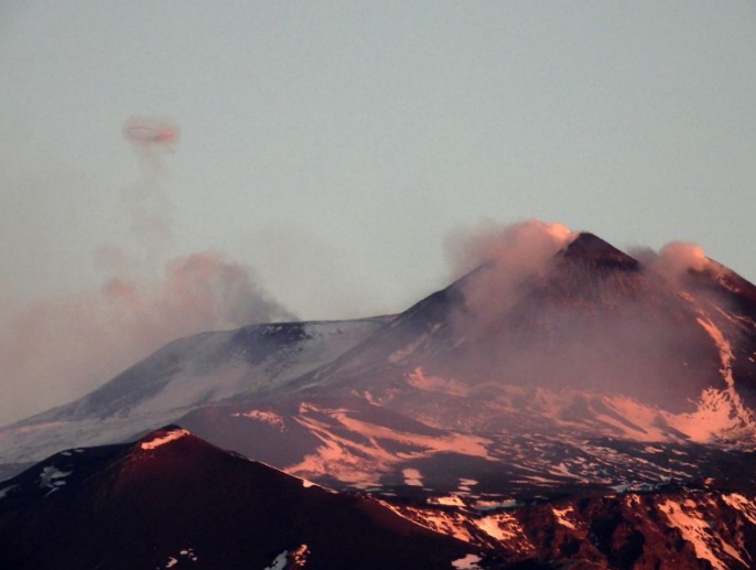
The South-East crater (right) and the Bocca Nuova crater (left) seen from the South at dawn on February 16, 2024. Degassing is visible at the two mouths (« selle » and « east ») from the Southeast crater is a ring of gas that has just been emitted by BN-2.
VOLCANOLOGICAL OBSERVATIONS
During the week of February 12 to 18, 2024, the monitoring of the volcanic activity of Etna was carried out through the analysis of images from the surveillance camera network of the National Institute of Geophysics and Volcanology, Osservatorio Etneo (INGV-OE).
During the observation period, outgassing activity was observed at Southeast Crater (CSE) and Bocca Nuova Crater (BN).
During the week, the degassing activity continued without change, continuously from the two main vents (“the saddle” and “East”) of the South-East Crater as well as some fumaroles on the North rim. from the crater, and in a pulsed manner from the two open vents (BN-1 and BN-2) inside the Bocca Nuova crater. In particular, gas rings (“volcanic vortex rings”) were emitted from BN-2, as often in recent months. Some nights, the most sensitive surveillance cameras recorded weak lightning in the fumarole zone located on the northern rim of the southeast crater. The two other summit craters, Voragine and Northeast Crater, remained blocked and with very little fumarolic activity.
Source et photo : INGV.
Italy , Stromboli :
WEEKLY BULLETIN, from February 12, 2024 to February 18, 2024. (issue date February 20, 2024)
SUMMARY STATEMENT OF ACTIVITY
In light of the monitoring data, it appears:
VOLCANOLOGICAL OBSERVATIONS: Normal Strombolian activity was observed during this period. The total hourly frequency of explosions fluctuated between average values (5 to 14 events/hour); the intensity was low in the North crater area and variable from low to high in the South-Central area.
2) SISMOLOGY: The monitored seismological parameters do not show significant variations.
3) GROUND DEFORMATIONS: The island’s ground deformation monitoring networks showed no significant changes to report for the period under review.
4) GEOCHEMISTRY: Mid-level SO2 flux.
The CO2 flow in the summit zone: there are no updates.
C/S ratio in the plume: medium-high values.
Helium Isotope Ratio in Thermal Aquifer: There are no updates.
CO2 flow in Scari: remains stable at average values.
5) SATELLITE OBSERVATIONS: Thermal activity observed by satellite was generally weak.
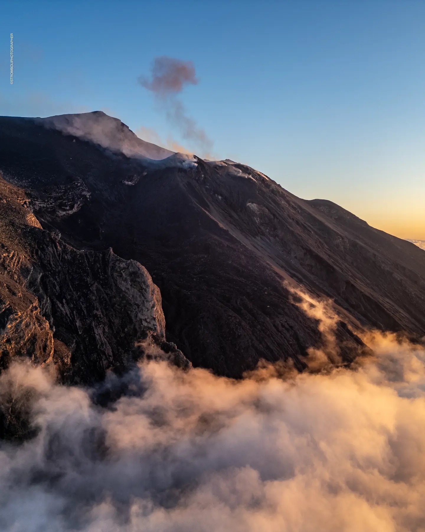
VOLCANOLOGICAL OBSERVATIONS
In the observed period, the eruptive activity of Stromboli was characterized through the analysis of images recorded by the INGV-OE surveillance cameras located at Pizzo sopra la Fossa.
(SPT), at 190 m altitude (SCT-SCV) and at Punta dei Corvi (SPCT). The explosive activity was mainly produced by 3 eruptive vents located in the North crater area and by 2 vents located in the South-Central crater area.
Observations of explosive activity captured by surveillance cameras
In correspondence with the area of the North crater (N), characterized by two vents located in sector N1 and one vent located in sector N2, low intensity explosive activity was observed (the erupting products reached a height less than 80 m). The products emitted in the eruption were mainly coarse materials (bombs and lapilli). The average frequency of explosions fluctuated between 3 and 4 events/hour.
In the Central-South zone (CS), sectors S1 and C did not show significant activity, while in sector S2, the two active vents showed explosions of varying intensity from low (less than 80 m in height) up to high (greater than 150 m) with emission of fine material mixed with coarse materials. The average frequency of explosions varied between 1 and 10 events/hour
Source : INGV
Photo : Stromboli stati d’animo / Sebastiano Cannavo.
Iceland , Reykjanes Peninsula :
Updated hazard assessment
Model calculations suggest magma accumulation will reach similar level as was noted prior to last eruption by the end of February or beginning of March
Updated 20. February at 11:00 UTC
The Icelandic Meteorological Office has issued an updated hazard assessment map following the decision of the National Police Commissioner to repeal the order of a temporary evacuation from Grindavík, taking effect on the 19th of February, and due to the decision of the Police Commissioner in Suðurnes regarding changes in access restrictions for both individuals as well as business operations.
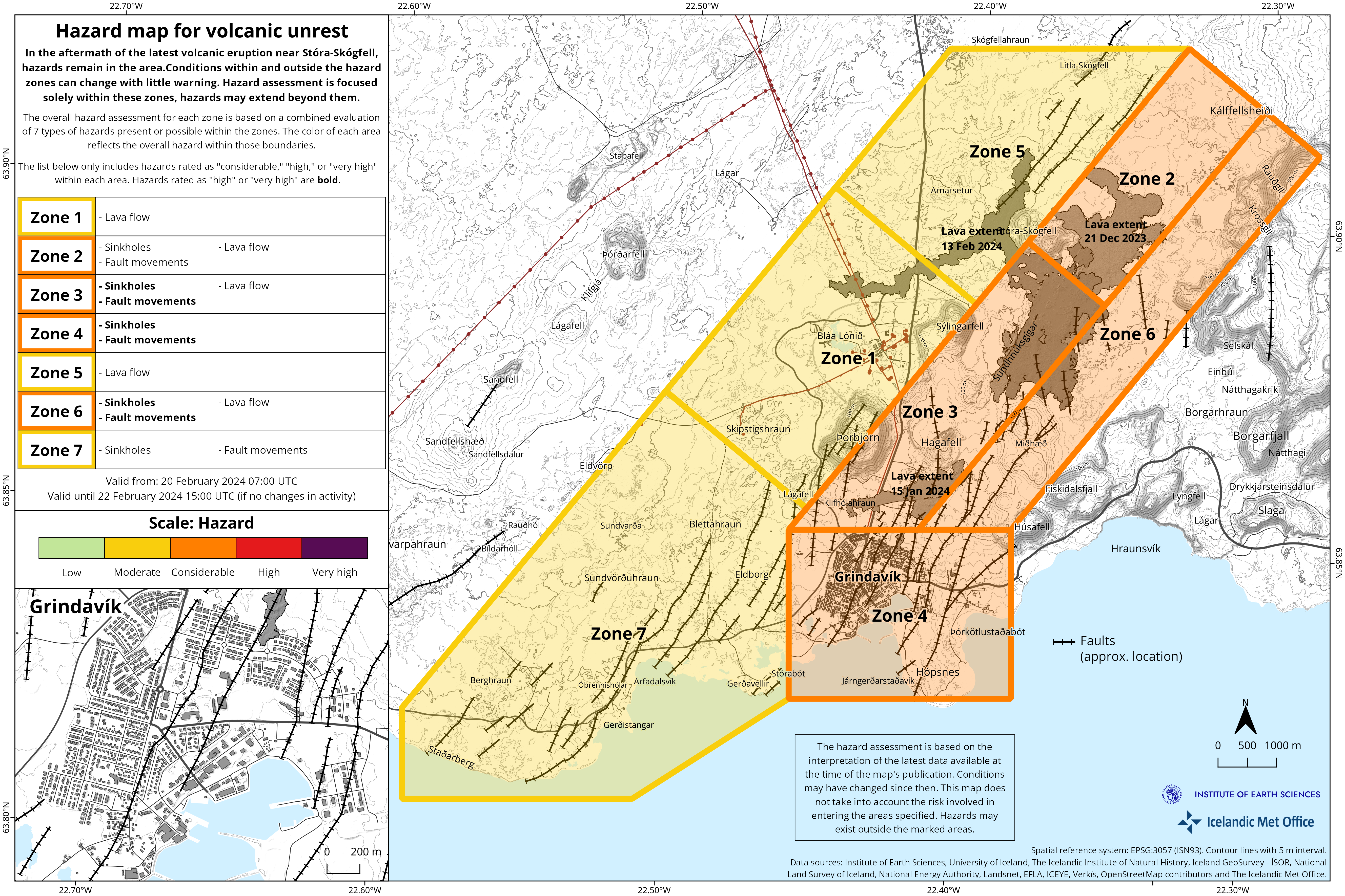
An updated hazard assessment map is valid from 20th of February at 7AM, which is the same time as the decision of the Police Commissioner in Suðurnes goes into effect.
In the latest version of IMO’s hazard assessment map, Zone 7 has been added in consultation with Civil Protection. Nesvegur road is within Zone 7, which is currently more used to access Svartsengi and Grindavík. Hazards present in Zone 7 are fault movements and sinkholes. Colour code of other areas remain unchanged from previous hazard map.
As before, the map shows assessment of hazards currently at hand, as well as hazards which might occur with short notice. An assessment has only been made for hazards within the defined Zones, but hazards can also be present outside of them.
Source et photo : IMO
Indonesia , Dukono :
An eruption of Mount Dukono occurred on Wednesday 21 February 2024 at 12:30 WIT with the height of the ash column observed at ±1,500 m above the summit (±2,587 m above sea level) . The ash column was observed to be white to gray in color with thick intensity, oriented towards the West. At the time of writing, the eruption was still ongoing.
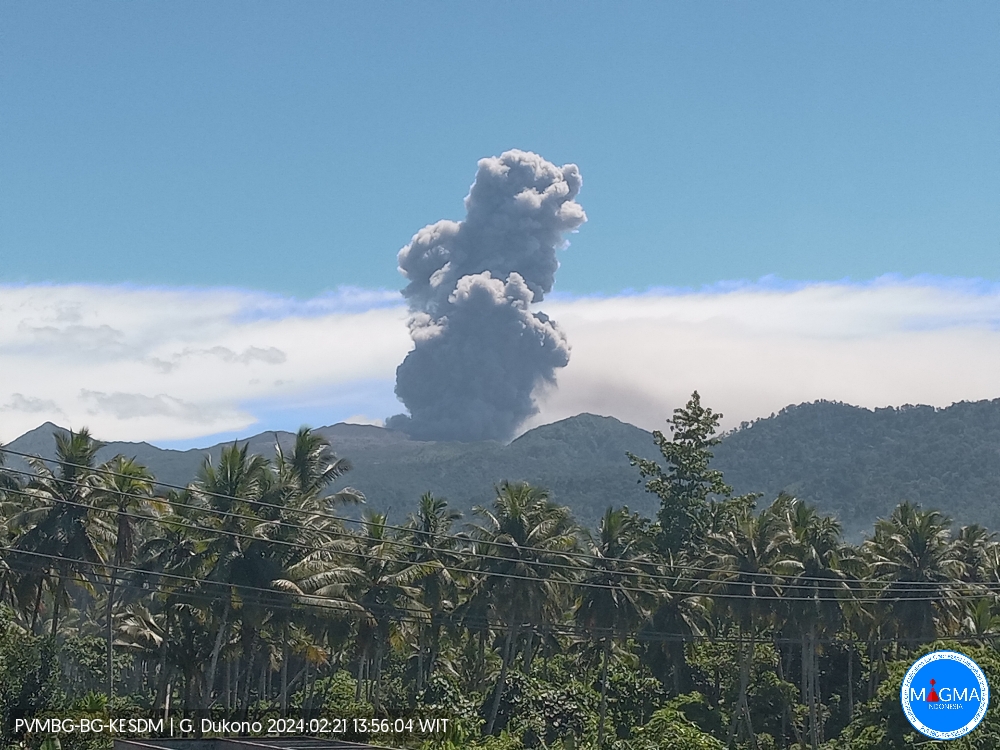
SEISMICITY OBSERVATIONS:
31 eruption/explosion earthquakes with an amplitude of 4 to 27 mm and an earthquake duration of 28.62 to 88.2 seconds.
6 deep tectonic earthquakes with an amplitude of 4 to 34 mm, and an earthquake duration of 62.26 to 74.8 seconds.
1 Continuous tremor with an amplitude of 0.5 to 4 mm, dominant value of 1 mm.
Recommendation
People around Mount Dukono and visitors/tourists are advised not to do activities, climb or approach the Malupang Warirang crater within a 3 km radius.
Source et photo : Magma Indonésie.
Colombia , Chiles / Cerro Negro :
Weekly activity bulletin of the Chiles and Cerro Negro Volcanic Complex (CVCCN)
Regarding the monitoring of the activity of the CHILES AND CERRO NEGRO VOLCANOES, the MINISTRY OF MINES AND ENERGY, through the COLOMBIAN GEOLOGICAL SERVICE (SGC), reports that:
Between February 13 and 19, seismic activity continued to show low and fluctuating levels, both in terms of occurrence and energy released, where earthquakes linked to rock fracturing predominated. Although in smaller quantities than the previous week, the recording of seismic events associated with the movement of fluids inside the volcanic complex continued, some of them with very low frequency contents.
The fracture earthquakes were located mainly to the south of the Chiles volcano, at distances less than 4.4 km, with depths between 1 and 8 km from its summit (4,700 m above sea level) and a maximum magnitude of 1.9.
Volcanic deformation processes recorded by ground-mounted sensors and remote satellite sensors continued.
The evolution of activity in the CVCCN is the result of internal processes derived from the complex interaction between the magmatic system, the hydrothermal system and the geological faults of the area. Thus, the probability of the occurrence of energetic earthquakes that can be felt by residents of the CVCCN zone of influence continues.
Volcanic activity remains on YELLOW ALERT Status: Active volcano with changes in baseline behavior of monitored parameters and other manifestations
Source et photo : SGC