March 14 , 2020 .
Alaska , Semisopochnoi :
51°55’44 » N 179°35’52 » E,
Summit Elevation 2625 ft (800 m)
Current Volcano Alert Level: ADVISORY
Current Aviation Color Code: YELLOW
A pattern of periodic short tremor bursts and small earthquakes continued this week at Semisopochnoi. These events were not associated with any indication of surface activity except for a possible infrasound detection on Thursday morning. Low-level, but continuous seismic tremor has been observed over the past day. Clear satellite views, especially later in the week, also did not indicate any significant surface activity. A clear high resolution image on March 9 showed steam filling the North Cerebus crater where active steam emissions have been observed throughout the current period of unrest. While there is no indication that activity is increasing towards an eruption in the short-term, explosive activity could resume with little to no warning.
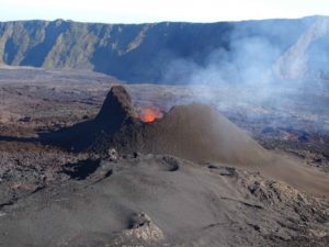
Mt Cerberus from the east. Photos of Semisopochnoi Island taken in May 2017 during AVO station maintenance activities and supported by U.S. Coast Guard.
Semisopochnoi is monitored with an on-island seismic network and remotely by satellite and lightning sensors. Furthermore, an infrasound array on Adak Island may detect explosive emissions from Semisopochnoi with a 13 minute delay if atmospheric conditions permit.
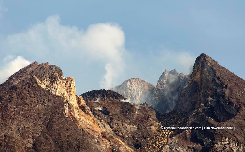
Remote Semisopochnoi volcano occupies the largest, young volcanic island in the western Aleutians. The volcano is dominated by an 8-km (5-mile) diameter caldera that contains a small lake and a number of post-caldera cones and craters. The age of the caldera is not known with certainty but is likely early Holocene. The last known eruption of Semisopochnoi occurred in 1987, probably from Sugarloaf Peak on the south coast of the island, but details are lacking. Another prominent, young post-caldera landform is Mount Cerberus, a three-peaked cone cluster in the southwest part of the caldera. The island is uninhabited and part of the Alaska Maritime National Wildlife Refuge. It is located 65 km (40 mi) northeast of Amchitka Island and 200 km (130 mi) west of Adak.
Source : AVO.
Photo : Kaufman, Max.
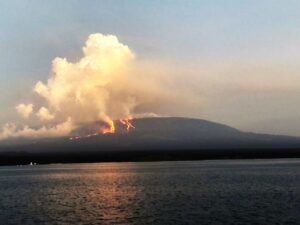
Kamchatka , Klyuchevskoy :
56.06 N, 160.64 E;
Elevation 15580 ft (4750 m)
Aviation Colour Code is ORANGE
A moderate explosive eruption of the volcano continues. Ash explosions up to 16,400-23,000 ft (5-7 km) a.s.l. could occur at any time. Ongoing activity could affect low-flying aircraft.
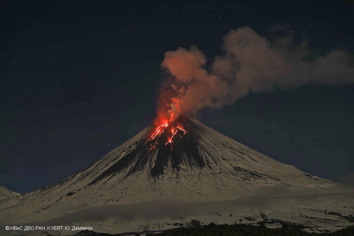
A moderate explosive eruption of the volcano continues, the Strombolian and gas-steam activity were noted all week. The number of hot avalanches descending along all the slopes of the volcano has increased significantly. Satellite data showed a bright thermal anomaly over the summit volcanic crater all week; gas-steam plumes containing some amount of ash extended for 135 km to the east, northeast and north of the volcano on 08-09 and 12 March.
Source : Kvert.
Photo : Yu Demyanchuck , IVS FEB RAS , KVERT.
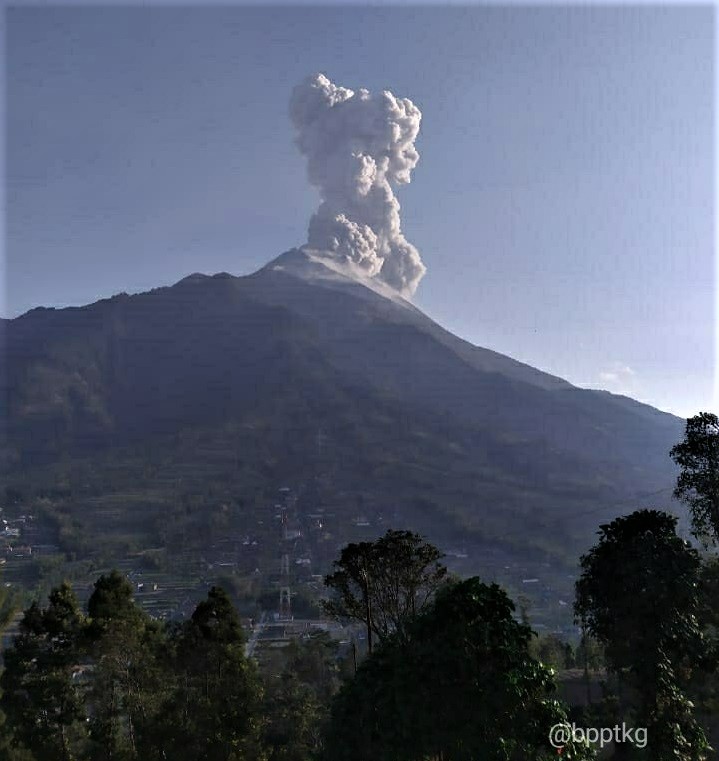
Indonesia , Merapi :
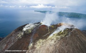
Activity report of the Merapi volcano from March 6 to 12, 2020.
OBSERVATION RESULTS.
Visuals
The weather around Mount Merapi is generally sunny in the morning and at night, while the afternoon until evening is foggy. We note the emission of white smoke, from thin to thick with low pressure. The maximum smoke height of 20 m was observed from the Mount Merapi observation post in Kaliurang on March 11, 2020 at 5:50 a.m. Morphological analysis of the peak and crater this week could not be carried out because the camera and its support devices were under maintenance. The volume of the lava dome based on measurements using aerial photography with drones on February 19, 2020 amounted to 291,000 m3.
Seismicity:
This week, the seismicity of Mount Merapi showed
2 shallow volcanic earthquakes (VTB),
8 multi-phase earthquakes (MP),
14 avalanche earthquakes (RF),
6 low frequency (LF) earthquakes
10 tectonic earthquakes (TT).
The seismicity this week is lower than that of last week.
Deformation:
The deformation of G. Merapi, who was monitored by EDM and GPS this week, showed no significant change.
Rain and lahars:
This week, there was rain at the Mount Merapi observation post with the highest rain intensity of 36 mm / hour for 50 minutes at the Kaliurang post on March 10, 2020. There was neither lahars nor additional flow in the rivers that descend from Mount Merapi.
Conclusion:
Based on the results of the visual and instrumental observations, it was concluded that:
1. The lava dome is currently in a stable state.
2. The volcanic activity of Mount Merapi is still quite high and is determined by the level of activity « WASPADA ».
3. The current potential danger is in the form of the descent of hot clouds from the collapse of the lava dome and explosions of volcanic material from explosive eruptions.
Source : BPPTKG.
Photos : Oystein Lund Andersen , BPPTKG.
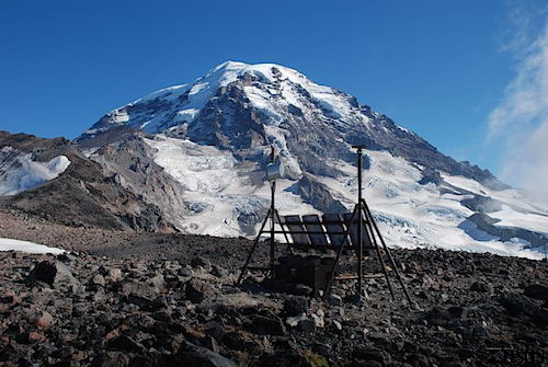
United – States , Mount Rainier :
Another seismic swarm at Mount Rainier
March 12, 2020
Beginning on March 10, 2020, a minor swarm of approximately 20 earthquakes occurred under the summit of Mount Rainier. Thirteen of those events were large enough to be located. The largest earthquake in the swarm was a Magnitude 1.5, and depths focused between 1.5 and 2.0 km (about 1 to 1.2 miles) below sea level. Earthquake rates have since returned to normal, background levels.
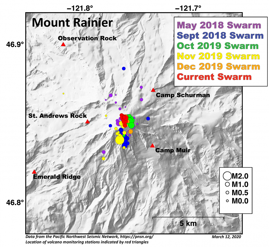
Swarms under the summit of Mount Rainier are fairly common, with the last one occurring in late 2019. Such swarms are thought to occur due to minor changes in the hydrothermal system of the volcano.
Seismic data for Mount Rainier and other Cascade Range volcanoes are available from the Pacific Northwest Seismic Network and Activity Updates for volcanoes in the Cascade Volcano Observatory’s area of responsibility are posted weekly.
Recent Observations:
Monitoring systems show that activity at Cascade Range volcanoes remained at background levels throughout the week. Small earthquakes were detected at Mount St. Helens and Mount Rainier, consistent with the normal range of seismic activity at these volcanoes.
The U.S. Geological Survey and Pacific Northwest Seismic Network (PNSN) continue to monitor these volcanoes closely and will issue additional updates and changes in alert level as warranted.
Source : CVO.
Photos : USGS.
Mexico , Popocatepetl :
March 13, 11:00 am (March 13, 11:00 GMT).
In the past 24 hours, using Popocatépetl volcano monitoring systems, 163 exhalations have been identified, accompanied by water vapor, volcanic gases and small amounts of ash. In addition, a minor explosion was recorded earlier today at 7:01 a.m., which had a low ash content which dispersed in a southwest direction. There were also 97 minutes of tremors.
At the time of this report, volcanic gas emissions and slight amounts of ash were presented, dispersing preferentially towards the Southwest.
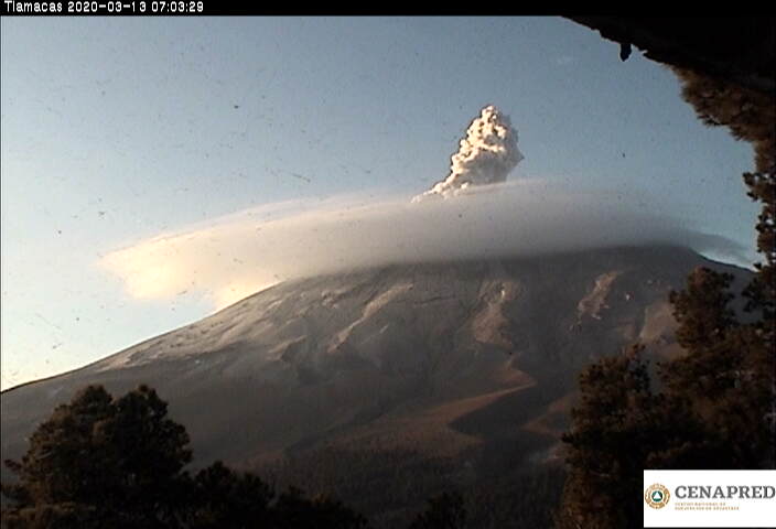
CENAPRED urges NOT TO APPROACH the volcano and especially the crater, because of the danger of falling ballistic fragments and, in the event of heavy rain, to move away from the bottom of the ravines because of the danger of flows mud and rubble.
The Popocatépetl volcanic alert signaling light is in YELLOW PHASE 2.
At 8:45 p.m., an explosion generated an eruptive column approximately 1,500 meters high containing ash and glowing material, which dispersed to the northwest of the state.
Source : Cenapred . municipiospuebla.mx