February 17 , 2020 .
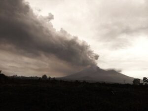
La Réunion , Piton de la Fournaise :
Activity bulletin for Sunday February 16 at 4:00 p.m. (local time)
Alert level: 2-2
After falling rapidly during yesterday (02/15/2020) from 2 p.m. (local time), a residual tremor was recorded at the seismological stations closest to the eruption until 2:12 p.m. local time today (02/16/2020, Figure 1). Since then, only a few sporadic puffs of gas have been recorded at seismological stations.
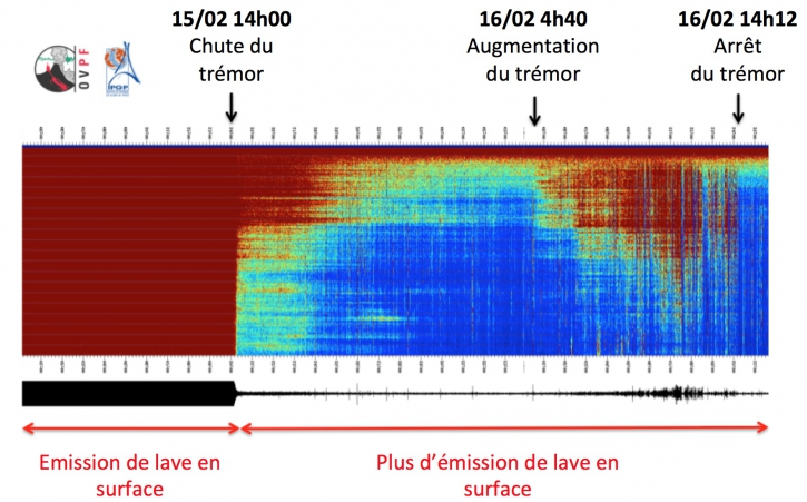
Figure 1: Spectrogram showing the evolution of the seismic signal between 02/15/2020 and 02/16/2020 4:00 p.m. local time (12:00 p.m. UT) on the FLR seismological station located on the eastern flank of the volcano. (© OVPF / IPGP).
Activity bulletin from Monday February 17 at 08:40 (local time).
Following the shutdown of the volcanic tremor on 02/16/2020 at 2:12 p.m. local time, no recovery was noted. The eruption therefore stopped on 2/16/2020 at 2:12 p.m.
No earthquake has been recorded since the eruption ended.
Note that a satellite acquisition on 02/16/2020 at 10.35 local time, still showed a thermal anomaly at the level of the eruptive vent (Figure 1). This anomaly as well as the persistent gas flushes on the morning of 2/16/2020 indicated a weak residual subsurface activity until the final shutdown of the tremor at 2:12 p.m.
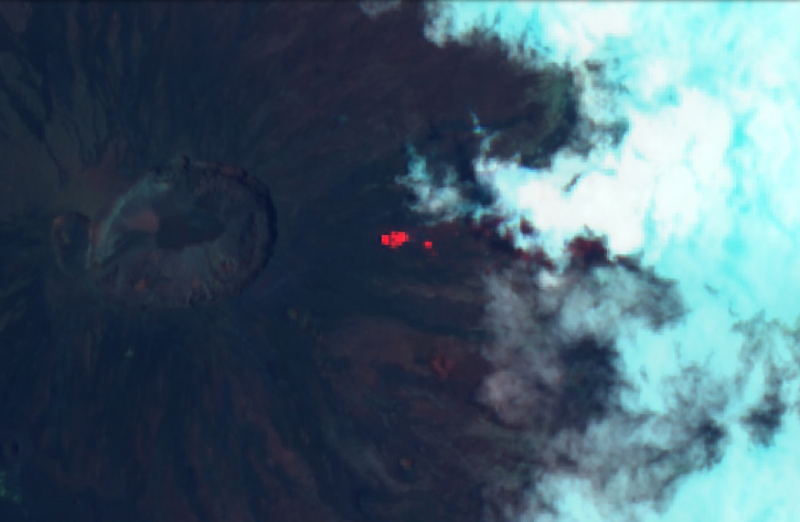
Figure 1: Thermal anomaly detected by an ESA (European Space Agency) image processed by sentinel playground. (© ESA / Sentinel).
Suggested alert level: Backup.
Source : OVPF.
Read the articles : http://www.ipgp.fr/fr/ovpf/bulletin-dactivite-dimanche-16-fevrier-a-16h00-heure-locale
http://www.ipgp.fr/fr/ovpf/bulletin-dactivite-lundi-17-fevrier-a-08h40-heure-locale
Alaska , Semisopochnoi :
51°55’44 » N 179°35’52 » E,
Summit Elevation 2625 ft (800 m)
Current Volcano Alert Level: WATCH
Current Aviation Color Code: ORANGE
Seismic data shows continued activity with small explosions and tremor bursts lasting from six to ten minutes every few hours. No ash plumes have been observed, however low-level ash emissions may accompany these minor explosions. Any ash emissions may be obscured by variable cloud cover at the volcano between 5,000 and 15,000 ft.
Semisopochnoi is monitored by local seismic sensors, satellite data and distant lightning networks. An infrasound array on Adak Island may detect explosive emissions from Semisopochnoi with a slight delay (approximately 13 minutes) if atmospheric conditions permit.
Source : AVO.
Photo : Roger Clifford.
Philippines , Taal / Mayon :
TAAL VOLCANO BULLETIN: 17 February 2020 8:00 A.M.
Activity in the Main Crater in the past 24 hours has been characterized by weak emission of steam-laden plumes rising 100 to 200 meters high before drifting southwest. Sulfur dioxide (SO2) emission was measured at an average of 58 tonnes/day on February 16, 2020. The Taal Volcano Network recorded sixty-five (65) volcanic earthquakes that are associated with rock fracturing processes beneath and around the edifice.
Alert Level 2 is maintained over Taal Volcano.
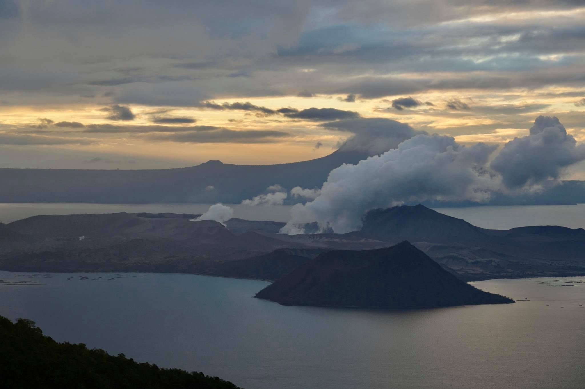
MAYON VOLCANO BULLETIN: 17 February 2020 08:00 A.M.
Mayon Volcano’s seismic monitoring network recorded one (1) volcanic earthquake during the 24-hour observation period. Weak to moderate emission of white steam-laden plumes that crept downslope before drifting west-southwest to southwest was observed. Sulfur dioxide (SO2) emission was measured at an average of 529 tonnes/day on 14 February 2020. Recent electronic tilt data showed inflation of the middle to upper portions of the volcanic edifice that began in the last quarter of 2019. This follows an inflationary trend that began in February 2019 as recorded by continuous GPS monitoring.
Source : Phivolcs.
Photo : Raffy Tima.
Iceland , Mt Thorbjorn :
The earthquake activity in the area north of Grindavík has decreased but is still above average, but less than when it peaked in the end of January. The largest earthquake detected in last week was M3.2 on the 11th of February at 18:46 west of Thorbjorn.

Indications are that the crustal deformation has decreased but is still ongoing. Additional monitors have been installed around Thorbjorn with two new seismographs installed last week. Gas will be monitored regularly and scientists recommend the continuing monitoring of the area.
The most likely explanation of the uplift and earthquake activity is that a magmatic intrusion is located at 3 to 5 km depth just west of Þorbjörn. It is most likely that this activity will stop without an eruption. The next meeting of the scientific council of Civil Protection will, Thursday February 20th.
Source : Vedur is .
Mexico , Popocatepetl :
February 16, 11:00 a.m. (February 16, 5:00 p.m. GMT)
According to the monitoring systems of the Popocatepetl volcano, 248 exhalations and 395 minutes of tremors have been identified. Some of these events were accompanied by the emission of gas and small amounts of ash which dispersed to the northwest. In addition, there was a minor explosion accompanied by a column 1000 m high.
During the morning there was a sequence of low ash exhalations which averaged a maximum height of 700 m and a direction of dispersion oriented to the northwest.
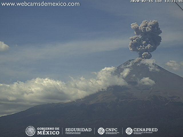
It should be noted that to date no reports have been received due to ash falls.
CENAPRED urges NOT to APPROACH the volcano and especially the crater, because of the danger of falling ballistic fragments, and in case of heavy rain to stay far from the bottom of the ravines because of the danger of mudslides and debris.
The Popocatépetl volcanic signaling light is in YELLOW PHASE 2.
Source : Cenapred .
Photo : Webcamdemexico .