November 10 , 2019.
Philippines , Taal :
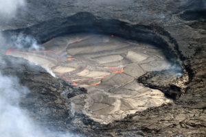
TAAL VOLCANO BULLETIN 09 November 2019 8:00 A.M.
Taal Volcano’s seismic monitoring network recorded thirty-six (36) volcanic earthquakes during the 24-hour observation period. Three (3) of these were felt events. The earthquake that occurred at 8:02 PM (last night) was felt at intensity II with rumbling sound by residents in Brgy. Alas-as, San Nicolas, Batangas. Two (2) earthquakes that occurred at 9:48 PM and 10:57 PM (last night), were felt at intensity I with rumbling sound in Barangay Alas-as, San Nicolas, Batangas. Field measurements on 07 November 2019 at the eastern sector of the Main Crater Lake yielded a decrease in water temperature from 33.0°C to 32.8°C, an increase in water level from 0.46 meters to 0.49 meters and an increase in acidity from a pH of 2.93 to 2.85. Ground deformation measurements through precise leveling surveys from 19 – 26 September 2019 indicated inflation of the edifice consistent with recent results from continuous GPS data.
Alert Level 1 remains in effect over Taal Volcano. This means that hazardous eruption is not imminent. The public, however, is reminded that the Main Crater should be strictly off-limits because sudden steam explosions may occur and high concentrations of toxic gases may accumulate. The northern portion of the Main Crater rim, in the vicinity of Daang Kastila Trail, may also become hazardous when steam emission along existing fissures suddenly increases. Furthermore, the public is also reminded that the entire Volcano Island is a Permanent Danger Zone (PDZ), and permanent settlement in the island is strongly not recommended.
Source : Phivolcs .
Photo : Mike Gonzalez / Wikipédia .
El Salvador , San Miguel ( Chaparrastique ) :
Special file 1. The Chaparrastic volcano presents a change in seismic behavior.
From the first week of October, a gradual change in seismicity recorded through the seismic monitoring network of the San Miguel volcano has begun, which has continued to this day. This change is associated with larger events of tremor impulses, highlighting the presence of small fractures in the duct of the volcanic system.
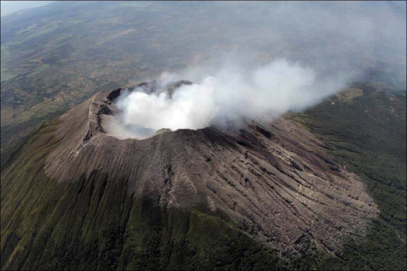
This state of volcanic activity is not considered a danger in the very short term, but it indicates that there are variations in the equilibrium conditions of the system. These changes are continually monitored and, if conditions exist that indicate an increase in activity, the population and the civil protection system will be notified in time.
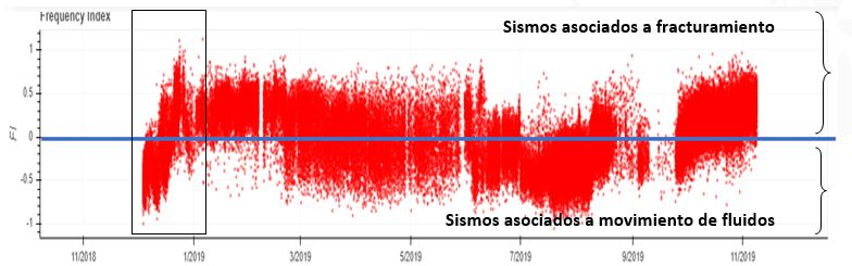
Indice de fréquence montrant l’évolution de la genèse de la sismicité enregistrée au cours de 2019.
The figure shows the evolution of the seismicity pattern recorded between December 2018 and November 2019. The red dots correspond to the recorded microsisms which, if they appear at the top of the blue line, are cataloged as follows: earthquakes associated with fracturing; and if they appear below, in the form of earthquakes associated with movements of fluid in the internal volcanic system. The box shows the trend changes recorded before and during the small ash ejection event observed in January 2019.
Source : Marn .
Photo : volcanohotspot .
Guatemala , Fuego :
Activity:
Presence of a degassing column at an approximate height of 4500 meters above sea level (14763 feet). From 16 to 20 weak to moderate explosions per hour have been generated that expel columns of gray ash at a height of 4,400 to 4,700 m / l (14435 to 15420 feet) that disperse between 17 and 20 kilometers to the west. and the Southwest. In the evening and early morning, incandescent pulses were observed at about 100 to 300 meters above the crater, with moderate to strong avalanches around the crater towards the Seca, Taniluyá, Ash, Trinidad and Las ravines. Lajas, who send materials to the edge of vegetation.
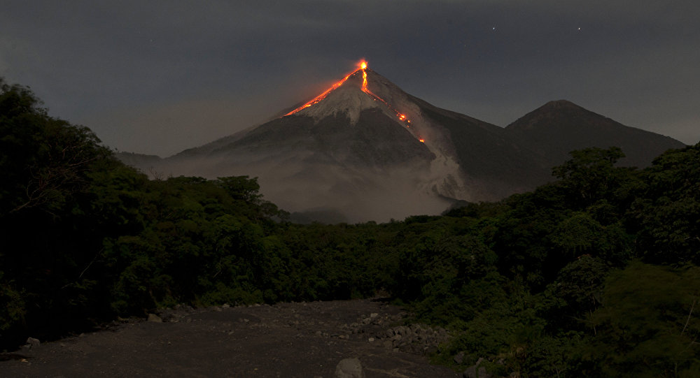
Low to moderate rumblings generate shockwaves that vibrate the houses of communities close to the volcano, with low to moderate gassing sounds at intervals of 10 to 12 minutes. Falls of fine ash particles are recorded in the areas of Panimaché I, Morelia, Santa Sofía, Porvenir, Palo Verde, Yepocapa and others located in this direction.
Lava flows to the Santa Teresa Canyon are approximately 800 meters long.
Source : Insivumeh.
Photo : Moises Castillo / Sputnik.
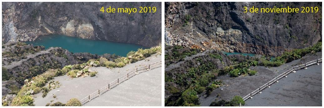
Costa Rica : Rincon de la Vieja / Irazu /
Rincon de la Vieja Volcano:
The seismic activity continued with the appearance of a large number of long-period (5 tens) and volcano-tectonic (one signal) signals, the vast majority of them recorded in more than two seismological stations. . Spasmodic tremor decreased in amplitude as of October 31st.
From a visit to the active crater of ICE officials, the main changes observed are described:
1- Strong soil erosion is observed on the southern edge of the crater, where at least 15-25 cm of soil has been eroded. In fact, part of the rim of the crater slipped and, as a result, the surface runoff resulting from the rains changed its drainage pattern and flow, which caused intense erosion. The possibility that there is a tilting of blocks on the southern flank that would cause a change of slope, and therefore a new drainage scheme, is not excluded.
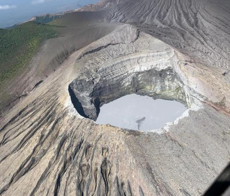
2- The level of the intra-crateric lagoon is at its lowest level since it was monitored between October 2013 and October 2019, which seems to suggest that the level has gradually decreased, and that it could be the product lack of rain, increased temperature of the crater lagoon that causes more evaporation, or cracks or faults leading to increased permeability under the lake, or a mixture of the three previous proposals . For the moment, none of the three possibilities has been proven.
3- Compared to previous years, the fumaroles located on the south-west side of the crater have increased in quantity, and it is even possible to observe sulfur volcanoes, which had not been previously reported. Given that the photograph was taken at more than 150 m, it is estimated that the sulfur volcano may have a diameter of between 2 and 3 m.
4- A part of the crater’s western wall has come loose and the deposits can now be seen as a fan on the edge of the crater. A sulfur volcano formed on landslides.
It is recommended to stay away from the canals of rivers near the volcano in case of eruption, due to the possibility of primary lahars. In addition to the rains, ashes and accumulated material in the upper parts of the volcano could generate secondary lahars.
Irazú Volcano:
No significant volcanic processes have been reported during this week. During a field visit on November 3, it was observed that the level of crater lake had decreased significantly compared to previous months.
The decrease in the water level at the end of the rainy season could be attributed mainly to the processes of water infiltration due to fractures, because the processes of evaporation are not intense in this lake, as they are in the Poás volcano. In addition, the sliding of the inner wall of the crater is still active and deposits materials inside the lagoon. The bubble exit through the crater lagoon water continues slightly. The sulfur smell of fumaroles located in the northwest sector of the crater is also continuing. Visitors are reminded to respect the authorized boundaries, to take pictures in the National Park and to comply with the provisions of the park wardens.
Turrialba Volcano:
The Turrialba volcano showed a stable and weak state of activity. The column of water vapor and gas dispersed mainly to the western and southwestern sectors, with the exception of the early morning or it is dispersed towards the North-West sector. The seismic activity is little dominated by discrete low frequency earthquakes. The presence of two lakes at the top of the volcano continues, with variations depending on the rain, while a third body of water forms a few hours after the rains, then disappears. The incandescence recorded by the volcanic surveillance cameras in the active crater continues as intense as the previous week. No major changes in seismicity were reported compared to the previous week.

The public is reminded that the entrance to the Turrialba Volcano National Park, which coincides with a radius of 2 km around the active crater, is closed due to the activity of the volcano. Approaching the crater means a very high risk activity.
Source : RSN .
Lire le rapport : https://rsn.ucr.ac.cr/actividad-volcanica/reportes-volcanicos/13880-boletin-sobre-el-estado-actual-de-los-volcanes-6-de-noviembre-2019
Photos : Chris Allen / Sunquest helitours / RSN , Dr. Paulo Ruiz, RSN .