June 02 , 2019.
Italy / Sicily , Etna :
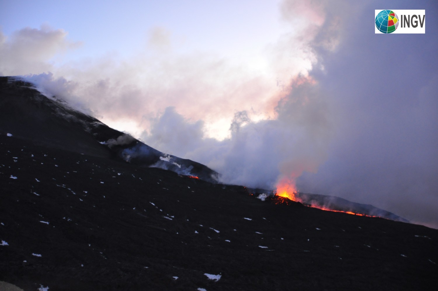
The National Institute of Geophysics and Volcanology, Osservatorio Etneo, announced that after an inspection carried out in the early hours of June 1 by the staff of the INGV, it was possible to ensure that the effusive activity continues to from the eruptive fissures activated on May 30th. Splashing continues and characterizes the 2850-m segment of the eruptive fissure at the eastern base of the new Southeast crater.
The meteorological conditions, characterized by the persistence of a constant cloud cover, did not make it possible to observe with precision the lava fronts, which however remain confined in Valle del Bove.
The trend of the mean amplitude of volcanic tremor continues to show a slightly decreasing trend, reaching average levels but not comparable to those recorded before the onset of eruption.
The National Institute of Geophysics and Volcanology, Osservatorio Etneo, announces that the analysis of the images of the cameras of the surveillance network has made it possible to observe that – from yesterday 21h30 – local time, the lava flow generated by the Eruptive fissure located at the north base of the new crater SE, at an altitude of about 3150 m, it is no longer fed and cools.
With regard to the eruptive fissure at the eastern base of the new Southeast crater, only the lava flow produced by the segment at an altitude of 2850 m, producing splash, remains active.
In a manner compatible with the weather conditions, an inspection of the INGV staff is planned at the end of the morning in order to carry out a direct study on the eruptive theater, which remains confined in the Valle del Bove.
During the last 24 hours, the average amplitude of the volcanic tremor continued to show a lower downward trend.
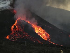
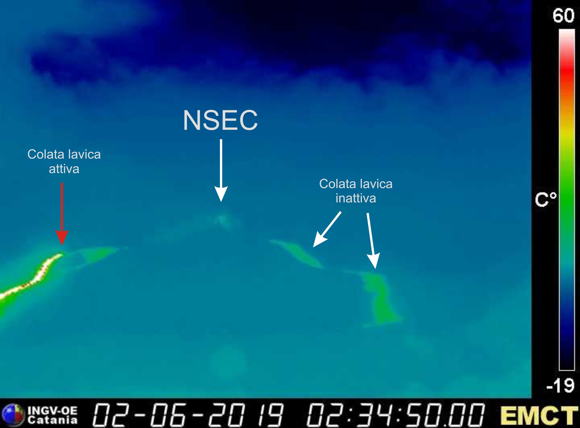
On the image, recorded by the thermal camera of Monte Cagliato (east slope of Etna) at 02:34 UTC (04:34 local time) on June 2, 2019, we can distinguish lava flow, now stopped and cooling, emitted by the eruptive fracture on the north side of the NSEC, and that still active, on the left, emitted from the vent at an altitude of 2,850 m to the southeastern base of the new crater of the Southeast. .
Source : INGV
Photos : Marco Neri (INGV-OE) , INGV.
Aleutians Islands , Great Sitkin :
AVO/USGS Volcanic Activity Notice
Current Volcano Alert Level: ADVISORY
Previous Volcano Alert Level: NORMAL
Current Aviation Color Code: YELLOW
Previous Aviation Color Code: GREEN
Issued: Sunday, June 2, 2019, 11:03 AM AKDT
Source: Alaska Volcano Observatory
Location: N 52 deg 4 min W 176 deg 6 min
Elevation: 5709 ft (1740 m)
Area: Aleutians
Volcanic Activity Summary:
A small steam explosion at 21:40 AKDT June 1 (5:40 UTC June 2) was detected at Great Sitkin Volcano in local seismic data. No corresponding signal was seen in regional infrasound data or cloudy satellite observations. Low-level seismic activity was elevated just before and after the event. In response to this activity, AVO is raising the Aviation Color Code YELLOW and Alert Level to ADVISORY.
Great Sitkin is monitored with a local real-time seismic network, which will typically allow AVO to detect changes in unrest that may lead to an explosive eruption. Rapid detection of an ash-producing eruption would be accomplished using a combination of seismic, infrasound, lightning, and satellite data.
Recent Observations:
[Volcanic cloud height] n/a
[Other volcanic cloud information] Unknown
Remarks:
Great Sitkin Volcano is a basaltic andesite volcano that occupies most of the northern half of Great Sitkin Island, a member of the Andreanof Islands group in the central Aleutian Islands. It is located 43 km (26 miles) east of the community of Adak. The volcano is a composite structure consisting of an older dissected volcano and a younger parasitic cone with a 3-km-diameter summit crater. A steep-sided lava dome, emplaced during an eruption in 1974, occupies the center of the crater. Great Sitkin erupted at least three times in the 20th century, most recently in 1974. That eruption produced at least one ash cloud that likely exceeded an altitude of 25,000 ft above sea level. A poorly documented eruption occurred in 1945, also producing a lava dome that was partially destroyed in the 1974 eruption. Within the past 280 years a large explosive eruption produced pyroclastic flows that partially filled the Glacier Creek valley on the southwest flank.
Source : AVO
Photo : Clum, Dave
La Réunion , Piton de la Fournaise :
Seismicity:
In May 2019, the OVPF recorded in the Piton de la Fournaise massif in total:
• 329 superficial volcano-tectonic earthquakes (0 to 2 km deep) beneath the summit craters;
• 3 deep earthquakes (> 2 km deep);
• 229 collapses (in the Crater Dolomieu and the ramparts of Enclos Fouqué).
Since May 21, a gradual increase in the number of superficial volcano-tectonic earthquakes (<2 km deep) beneath the summit craters has been observed. A strong seismicity was recorded on May 30th and 31st (125 superficial volcano-tectonic earthquakes, <2km deep) with notably two small short-lived seismic seizures on May 31st between 2.43am and 3.00am (local time) and between 4.29am and 4.37am ( local hour).
Deformation:
A resumption of inflation (swelling) of the building began in early May and continued throughout the month. Thus in May an elongation of about 1-1.5 cm max. of the summit area has been recorded. This phase of inflation is linked to a pressurization of the superficial magmatic reservoir located 1.5-2km deep below the summit.

Geochemistry of gases.
CO 2 concentration in the soil:
In the far field (Plaine des Cafres sector and Plaine des Palmistes): a new increase in CO2 concentrations in the soil has been recorded since the beginning of April 2019, reaching intermediate levels.
Composition of the summit fumaroles by the MultiGas method:
The MultiGas station at the summit has been operational since May 23 and has detected during the day of May 30, sulfur species in the air (H2S and to a lesser extent SO2).
SO 2 flux in the air in the Enclos Fouqué by DOAS method
Near or below the detection threshold.
Phenomenology
No eruptive activity during the month of May 2019.
Balance sheet
The recovery in inflation, as well as seismicity and CO2 concentrations in the soil show that deep magma recharge and pressurization of the superficial magmatic reservoir resumed in early May and continued through the month of May.
Source : OVPF
Photo : G Vitton
Mexico , Colima :
Weekly technical bulletin of the Colima Volcano activity
Date: May 31, 2019 Bulletin No. 123
Seismic activity:
Last week, 45 high frequency (HF) events, 15 landslides, 13 low intensity explosions and 24.3 min low amplitude tremor were automatically recorded. An explosion was recorded on May 30 at 6:26 am (11:26 UTC) at the INCA station located 1.9 km from the crater of the volcano.
Visual observations:
During the reporting period, small explosions and intermittent releases of steam and gas mainly from the northeast side of the crater continue to be recorded.
Two overflights were made on the crater of the volcano, May 23 and 24. The crack or cavity reported last week became a hole due to the combination of blast excavation and probable subsidence.

With the portable thermal camera, high temperatures were observed at the bottom of the crater, in the same area as those observed during previous flights. The maximum apparent temperature was 252 ° C, which represents an increase of approximately 80 ° C compared to the May 1 flight. The most active zone of fumaroles continues north-east of the crater, in the inner wall, and had a maximum apparent temperature of 202 ° C. It also indicates an increase in temperature, in this case about 40 ° C. .
Due to the high cloudiness recorded last week, it was not possible to detect any thermal anomalies that could have occurred with the explosions that occurred.
Geochemistry:
No SO2 flow measurements were performed during the last week.
Remote perception:
No thermal anomalies detected by the MIROVA satellite system were observed during the last week.
Diagnostic :
The volcano maintains an explosive activity of low intensity. The occurrence of these events indicates that the gas associated with the moving magma has reached superficial levels. This activity can continue and increase in intensity over the next few days or weeks. The staff in charge of monitoring the volcano is attentive to possible changes and changes in activity.
Source : UCOL