November 29 , 2018.
Colombia , Nevado del Ruiz :
Subject: Activity bulletin of the Nevado del Ruiz volcano.
The level of activity continues at the level: Yellow activity level or (III): Changes in the behavior of volcanic activity.
With regard to monitoring the activity of the Nevado del Ruiz volcano, the COLOMBIAN GEOLOGICAL SERVICE announces that:
Over the past week, the seismicity caused by rock fracturing has seen a decrease in the number of earthquakes and released seismic energy compared to the previous week. The earthquakes were mainly located in the Arenas crater and, to a lesser extent, in the Northeast, Southeast and Northwest zones at depths between 0.6 and 7.0 km. The maximum magnitude recorded during the week was 1.3 ML (local magnitude), which corresponds to the earthquake recorded on November 20 at 3:17 am (local time) in the crater Arenas, at a depth of 1.7 km .
Seismicity related to fluid dynamics, within the channels of the volcanic structure, showed a similar level of earthquake numbers and released seismic energy compared to the previous week. This activity was characterized by the presence of earthquakes with variable energy levels, long period (PL), very long period (VLP) and tremors. The earthquakes occurred mainly in the crater Arenas and its surroundings.
Volcanic deformation measured from electronic inclinometers, GNSS (Global Navigation Satellite System) stations and radar images have so far shown stability behavior without recording significant deformation processes of the volcanic structure.
During the week, the NASA FIRMS portal reported two low-energy thermal anomalies.
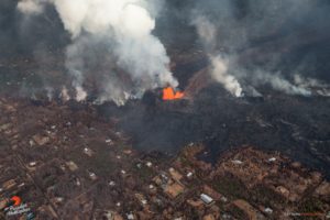
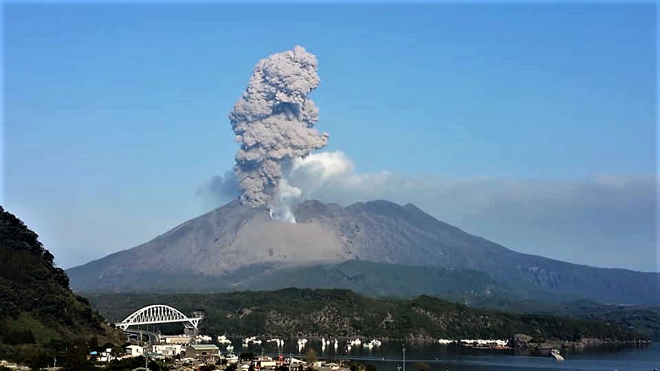
The column of gas, steam and ash reached a maximum height of 1300 m, measured at the top of the volcano on 25 November. The direction of column dispersion was governed by the direction of the wind in the area, which predominated to the northwest and north-east.
The Nevado del Ruiz volcano continues its activity at the level of yellow activity.
Source : SGC
Photo : Archive SGC ( 2012)
Japan , Aira ( Sakurajima) :
31,593 ° N, 130,657 ° E
Elevation : 1117 m
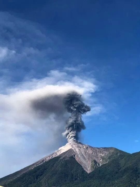
JMA reported that four events at Minamidake crater (at Aira Caldera’s Sakurajima volcano) were recorded during 19-22 November, producing ash plumes that rose as high as 1.6 km above the crater rim. Material was ejected 500-700 m from the crater. Occasional, very small events occurred during 22-26 November. Crater incandescence was visible at night during 20-21 November, for the first time since 20 September, and continued through 26 November. The Alert Level remained at 3 (on a 5-level scale).
Source: Agence météorologique japonaise (JMA) , GVP .
Photo : Auteur inconnu
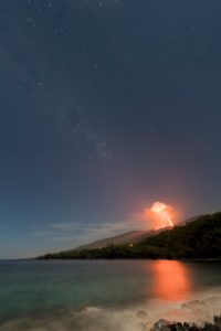
Guatemala , Fuego :
SPECIAL VOLCANOLOGICAL BULLETIN BEFGO # 224-2018. STRONG EXPLOSIONS WITH ABUNDANT EMISSIONS OF ASH. Guatemala on November 28, 2018 at 11:00 am (local time).
Type of activity: Vulcanian
Morphology: Composite Stratovolcan
Location: 14 ° 28’54˝ Latitude N; 90 ° 52’54˝ Longitude W.
Altitude: 3,763msnm.
The Fuego volcano, over the past few days has exhibited moderate to strong, vulcanian type explosions, which generate thick columns with copious amounts of ash. According to reports from the control tower at Aurora International Airport, ashes have been recorded up to 31,000 feet (9,449 msnm). The cloud travels 25 km to the South, Southwest and West. Ash falls are noted in Panimaché, El Porvenir, Morelia, Santa Sofia, Sangre de Cristo, Finca Palo Verde, San Pedro Yepocapa, among others.
The explosions are accompanied by moderate / loud rumblings, as well as shock waves, this activity causes vibrations of roofs and windows of houses near the volcano. At night and early in the morning, an incandescent was observed in the crater at an approximate height of 200 meters above the crater, causing weak to moderate avalanches around the crater, some descending long distances to the vegetation. towards the Seca, Taniluyá, Ceniza, Trinidad, Honda and Las Lajas ravines.
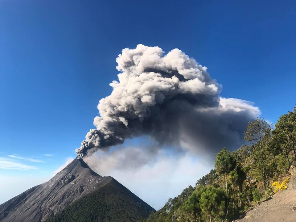
The seismic recording of the FG3 station shows slight increases associated with this volcanic activity, maintained with constant and sometimes prolonged explosions. Due to weather conditions, it is possible for the wind to change direction in height, which can lead to ash falling in other areas.
Source : Insivumeh
Photo : Edilverto Santos / Clima Guatemala via Bernard Duyck , Jessica Chicco .
Indonesia , Merapi :
Volcanology center advises 3 km safe distance from erupting Mt. Merapi .
27 NOVEMBER 2018. The Center for Volcanology and Geological Hazard Mitigation (CVGHM) has advised residents and visitors to stay away from Mount Merapi in Magelang, Central Java, following increased volcanic activity.
Since Aug. 11, steadily flowing viscous lava from the volcano – or effusive eruption – has created a lava dome on top of the mountain. The dome continues to grow daily as Mt. Merapi extrudes around 3,000 cubic meters of lava per day.
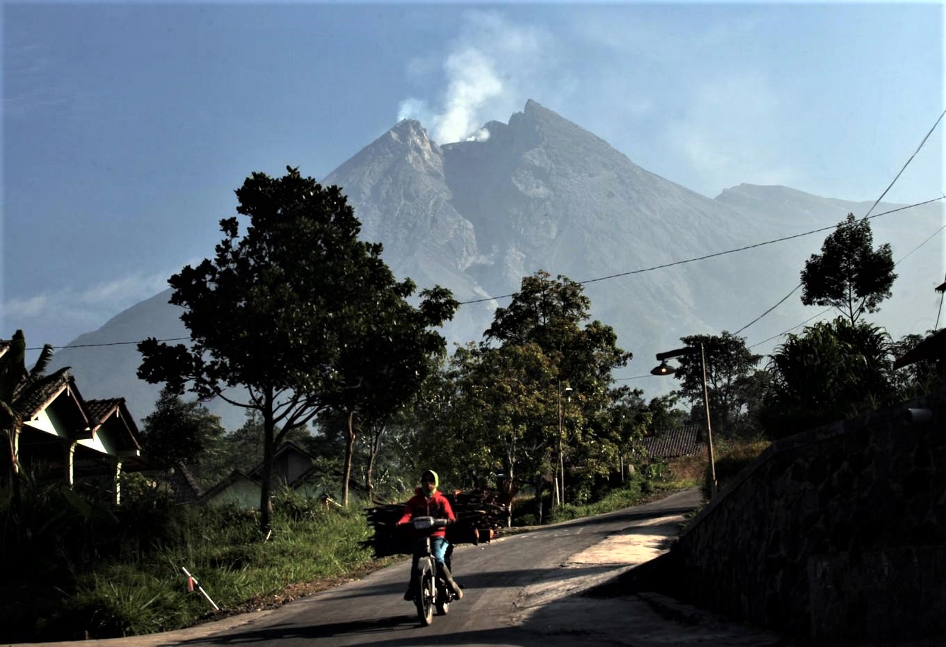
CVGHM head Kasbani said the growing dome could collapse at some point and spew hot clouds of volcanic gases as well as lava. Residents and visitors were thus advised to stay at a safe distance of at least 3 kilometers around the volcano.
“The lava dome, however, is still in a stable condition at present. Therefore, we will maintain the waspada [alert] status for now,” Kasbani said on Monday, referring to the second of the four-level national volcano alert system.
Separately, Agus Budi Santoso, the head of the Merapi Monitoring Post and the Geological Disaster Technology Research and Development Center (BPPTKG), said that the extrusion of hot clouds of gas from the dome could become a possibility if the lava flow increased to 600,000 cubic meters per day.
Source : The Jakarta Post
New Zealand , White Island (Whakaari) :
White Island (Whakaari) Crater Lake could reach overflow in mid-2019. Published: Thu Nov 29 2018 11:00 AM
The water level in the crater lake at White Island (Whakaari) has risen around 10 metres so far in 2018. If it continues to rise at the same rate it will start to overflow around mid-2019.
The crater lake at White Island has been steadily growing since a small lake became re-established in January 2018. The previous lake was destroyed following an eruption in April 2016 and excavated the crater floor by about 13 metres.
The graph below shows how the lake is currently filling. As at 27 November 2018, the lake is about 10 metres below overflow.
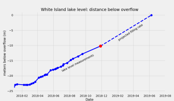
Plots showing the crater lake filling rates. The red dot is the current water level.
The lake has risen in a similar fashion three times in the last 15 years, coming close to, but never reaching overflow. In February-March of 2006 the lake got to within about 1 metre of overflow, before receding as the lake heated and evaporated.
Our last Volcanic Alert Bulletin explained that the growing crater lake could cause hydrothermal surface activity as it drowns some of the vents (fumaroles) near the lake. Drowning of the vents has led to steam-driven activity – geysering – however, most vents seem to have ‘drowned’ relatively quietly. This process is not over yet, with some vents still steaming away above lake level.

Implications of an overflowing lake
The overflow of the lake could pose a danger to people visiting the island. This danger relates to a large stream flowing across the Main Crater floor. The danger is mitigated, however by the low probability of the lake outlet failing and a flood occurring. Aspects of these hazards were examined in 2005 by GNS Science. We will continue to review as the lake refills.
Measuring water level rise
Steep slopes and soft ground make access to the lake difficult, so we are not always able to measure the water level directly. Instead, we use our web camera images and measurement techniques to measure water level. The first technique uses a topography model derived by drone imagery when the lake was not present. We identify the area drowned and calculate the depth (water level rise). The other uses the measurement of distances below a target on the crater rim on our web camera images, from which we can calculate a water level.

A montage of images from the West Rim web camera showing how the Crater Lake has been growing since January 2018.
Why is the crater lake level rising?
The water level rises largely for two reasons:
• Condensing of volcanic steam and gas from vents under the lake
• Rainfall into the lake catchment
Based on our calculations and analysis of water samples, we estimate about 75% of the fluid comes from condensing steam vents under the lake. The rest comes from rainfall, which means rain has caused about 2.6 metres of the water level rise.
Importantly, there is no substantial change in the level of volcanic activity at White Island. Crater Lakes have formed in the past and we do see changes in the geothermal activity associated with this, but no signs of increased volcanic unrest.
Source : Brad Scott, GNS Science Volcanologist.