June 04 , 2018.
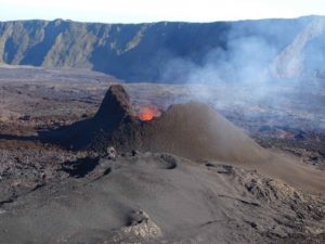
Pu’u ‘Ō’ō / Kilauea , Hawai :
Saturday, June 2, 2018, 7:39 PM HST (Sunday, June 3, 2018, 05:39 UTC)
19°25’16 » N 155°17’13 » W,
Summit Elevation 4091 ft (1247 m)
Current Volcano Alert Level: WARNING
Current Aviation Color Code: RED
Kīlauea Volcano Lower East Rift Zone
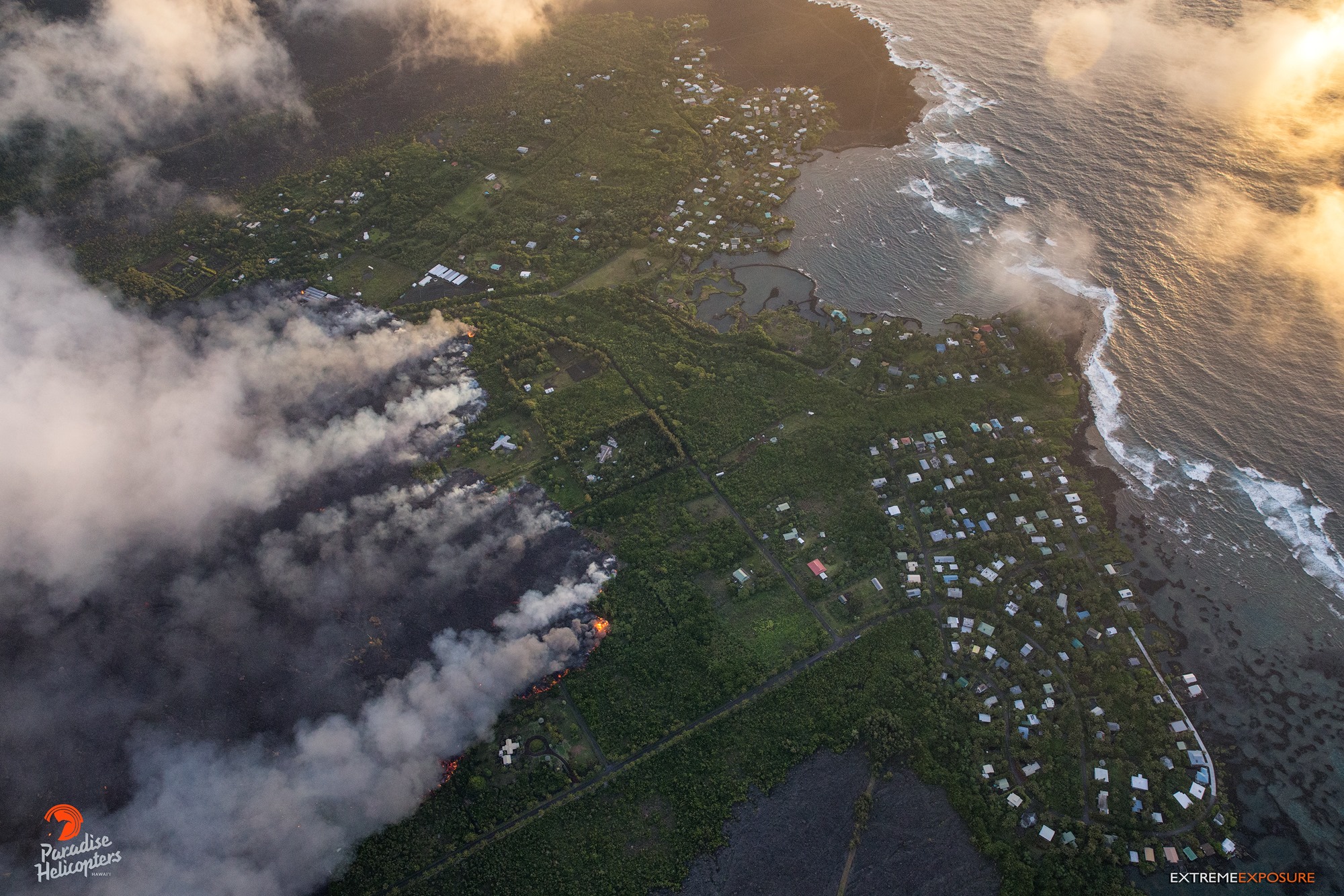
Vigorous eruption of lava continues from the lower East Rift Zone (LERZ) fissure system in the area of Leilani Estates and Lanipuna Gardens.
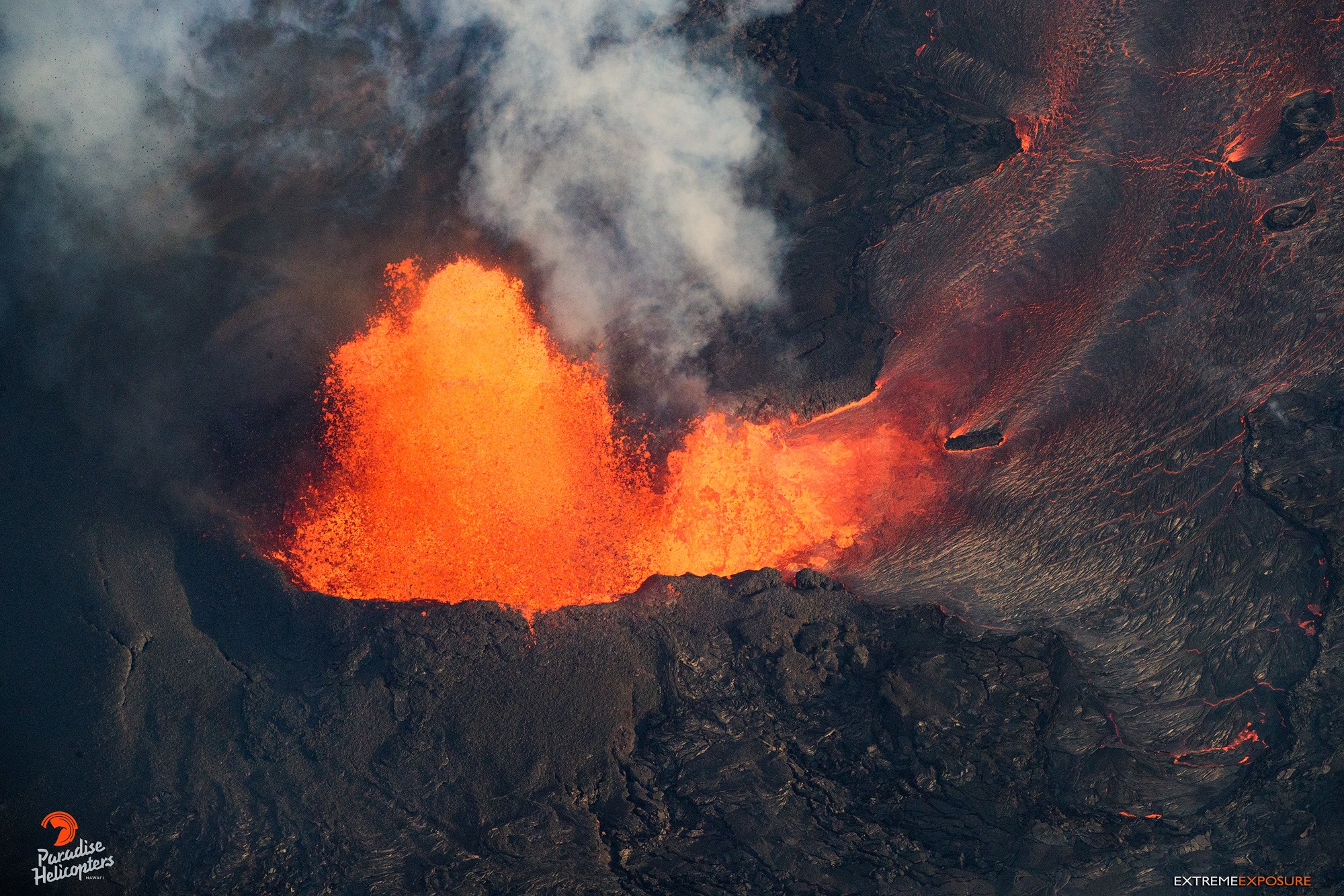
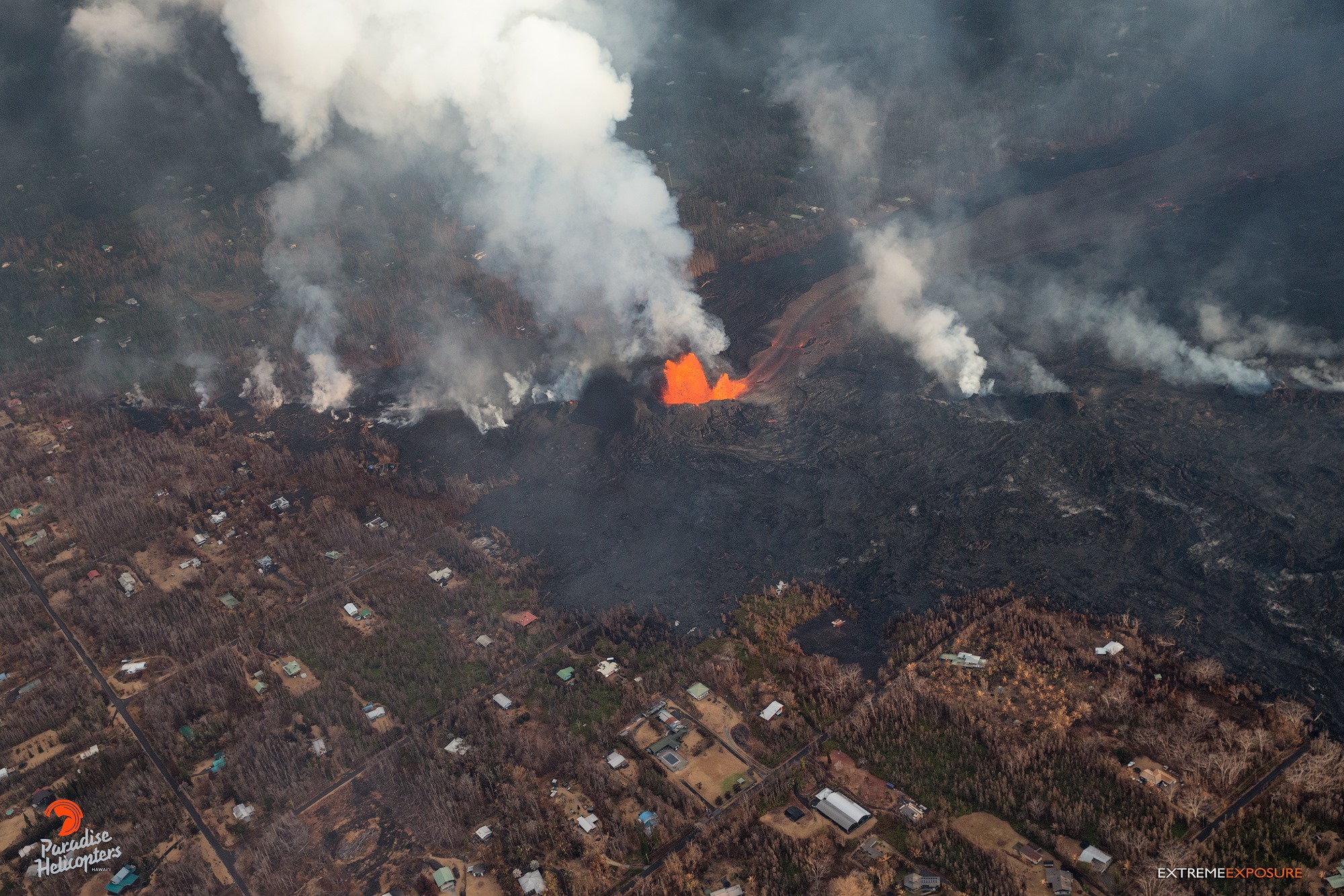
Fountaining at Fissure 8 continued unabated during the day, feeding a channelized lava flow to the northeast along Highway 132 that has crossed Highway 137 at the intersection of the two highways at 9:30 AM this morning. The flow continued advancing into Kapoho Crater and Kapoho Beach Lots. At 10 AM, lava entered Green Lake within Kapoho Crater producing a large steam plume. By 1:30 PM the steam plume had ceased and by 3 pm, a Hawaii County Fire Department overflight reported that lava had filled the lake and apparently evaporated all the water. Other branches of the Fissure 8 lava flow were inactive.
The only other lava flow noted by the morning overflight was at Fissure 16, which was weakly active.
Pele’s hair and other lightweight volcanic glass from high fountaining of Fissure 8 are falling downwind of the fissure and accumulating on the ground within Leilani Estates. Winds may waft lighter particles to greater distances. Residents are urged to minimize exposure to these volcanic particles, which can cause skin and eye irritation similar to volcanic ash.
HVO field crews are on site tracking the fountains, lava flows, and spattering from multiple fissures as conditions allow and are reporting information to Hawaii County Civil Defense.
Volcanic gas emissions remain very high from the fissure eruptions. Trade wind conditions are bringing vog to the south and west sides of the Island of Hawaii.
Magma continues to be supplied to the lower East Rift Zone. Earthquake locations have not moved farther downrift in the past few days and the number of located earthquakes remains low. Seismicity remains relatively low with numerous small magnitude earthquakes and low amplitude background tremor.
Additional ground cracking and outbreaks of lava in the area of the active fissures are possible. Residents downslope of the region of fissures should heed all Hawaii County Civil Defense messages and warnings.
USGS/HVO continues to monitor the lower East Rift Zone activity 24/7 in coordination with Hawaii County Civil Defense.
Kīlauea Volcano Summit
Earthquake activity at the summit overnight was low. Ash emissions are low as revealed by webcam views this morning. Small explosive events could produce minor amounts of ash fall downwind at any time. Volcanic gas emissions at the summit remain high.
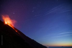
Kilauea – 04 June 2018 05:58:48
A moderate earthquake (5.5 preliminary) resulting from a volcanic explosion and continued collapse around Halemaumau occurred at 15:50 HST. Ash reached 8,000 ft. asl. Trace ashfall may occur over the Kau District.
Sunday, June 3, 2018, 10:40 AM HST (Sunday, June 3, 2018, 20:40 UTC)
Kīlauea Volcano Lower East Rift Zone
Fissure 8 fountaining persisted throughout the night, and the channelized flow continued to deliver lava northeast along Highway 132 to the Kapoho area. Lava is advancing along a 0.5-mile-wide front towards the ocean at Kapoho Bay between Kapoho Beach Road and Kapoho Kai Drive. As of 7:30 AM HST, the lava flow was about 430 yards from the ocean. Other branches of the Fissure 8 lava flow were inactive.
All other fissures are inactive, although Fissure 9 is steaming heavily.
Kīlauea Volcano Summit
Earthquake activity at the summit was high overnight, and it is possible that a small explosion, much like those that have occurred during the past two weeks, will take place in the next day. Ash emissions are low as revealed by webcam views this morning. Volcanic gas emissions at the summit remain high.
Sunday, June 3, 2018, 7:07 PM HST (Monday, June 4, 2018, 05:07 UTC)
Kīlauea Volcano Lower East Rift Zone
Fissure 8 fountaining persisted throughout the day to heights up to 220 feet, and the channelized flow continued to deliver lava northeast along Highway 132 to the Kapoho area. Lava is advancing along a 0.5-mile-wide front towards the ocean at Kapoho Bay between Kapoho Beach Road and Kapoho Kai Drive. As of 5:45 PM HST, the lava flow was about 245 yards from the ocean at its closest approach point. Other branches of the Fissure 8 lava flow were inactive.
All other fissures are inactive, although observers on the late afternoon overflight noted abundant gas emission from Fissures 9 & 10 and incandescence without fountaining at fissures 16 & 18.
Kīlauea Volcano Summit
Earthquake activity at the summit was high overnight and through the day. A moderate earthquake (5.5 preliminary) resulting from a volcanic explosion and continued collapse around Halemaumau occurred at 15:50 HST. National Weather Service radar observations confirmed an ash column was produced and reached 8,000 ft. asl.
Sources : HVO
Photos : Bruce Omori
Video : USGS
Fuego , Guatemala :
Volcanological SPECIAL BULLETIN BEFGO # 28-2018 Guatemala City 3 June 2018, 10:05 (local time)
ERUPTION WITH PYROCLASTIC FLOW IN THE SECA AND CENIZA RAVINS (1402-09)
Type of activity: Vulcanian
Morphology: Composite stratovolcano
Location: 14 ° 28’54˝ Latitude N; 90 ° 52’54˝ Longitude W.
Altitude: 3,763msnm.
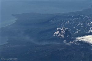
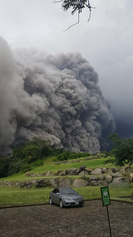
As reported, the Fuego volcano is in a new phase of eruption, generating strong explosions, with rumblings and shock waves, thick ash columns rising to 6000 meters. (19,645 feet) which are scattered to the West, North West, and North. This eruption continues to generate moderate pyroclastic flows towards the Seca or Santa Teresa ravines, also observed in the Ceniza Canyon. The volcano is still covered, with little visibility, so that the length of the flows is not observed.
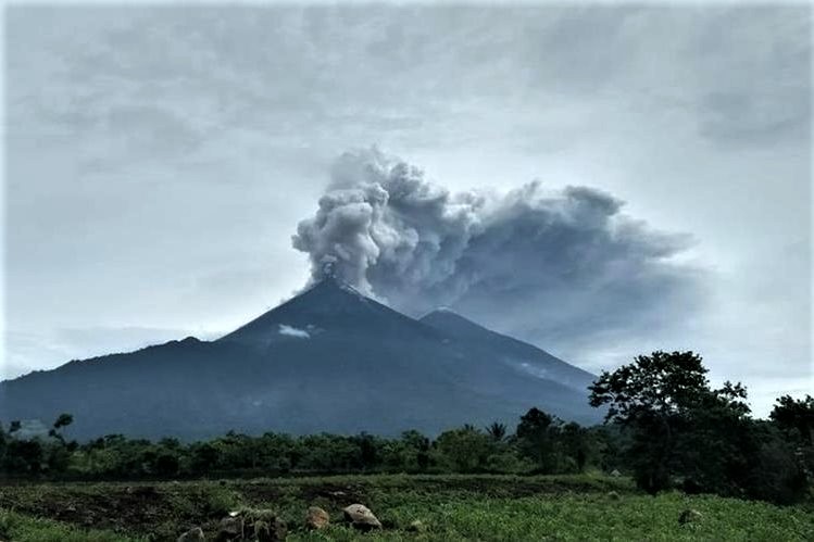
The column of ash products from the pyroclastic flows, moves to the villages of Sangre de Cristo, San Pedro Yepocapa, La Soledad, Quisache, the municipality of Acatenango and others in this area, with the possibility that the wind displaces the ashes on Chimaltenango, Parramos, Pastores and even on ancient Guatemala. It has been estimated that the column moves more than 40 kilometers in these directions, so it is recommended to take precautions. This eruption retains its energy and can generate pyroclastic flows in all the ravines around the Fuego volcano, so it is necessary not to stay in or near them because of the eruption. The wind being variable during the day, the column of ash can move constantly in several directions.
https://www.facebook.com/escuintlafriends/videos/1746704742084369/
The observatory of the Fuego volcano reports that the explosions are accompanied by loud rumblings, generating strong shock waves, which causes vibrations in the houses near the volcano, constant sounds like a locomotive machine.
SPECIAL BEFGO VULCANOLOGICAL BULLETIN # 33-2018 Guatemala 03 June 2018, 22:00 hours (Local Time)
END OF THE PAROXYSM OF FUEGO VOLCANO (1402-09)
The eruption of the Fuego volcano ended, after 16 hours of activity, with ashes to 4,500 m (14,763 feet), weak to moderate explosions, with a glow in the crater.
The seismogram and RSAM recordings of the seismic station FG3 record a last pyroclastic flux at 18. 45 hours, then normal explosions, with abundant degassing. The rumblings and the shock waves are gone. The eruption is complete, but there is ash in the atmosphere at a distance of 20 kilometers with the probability that the wind speed moves them further. We must also take into account that there is the probability of a recovery, so do not stay near or in the ravines concerned. The lahars, take into account that the flow of pyroclastic deposits filled the canyons and the rain of this winter season is important, they will be generated in the next hours or days. These can spill over villages and hamlets in the South, South-West and South-East and affect populations that have not been affected.
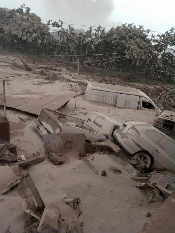
Guatemala’s Fuego volcano erupts, killing 25 people and injuring hundreds
The president plans to declare a state of emergency in the region while the smoke and ashes force the closure of the airport La Aurora of the capital
At least 25 people, including three children, were killed and nearly 300 wounded on Sunday in the most violent eruption of the Fuego volcano in Guatemala in more than four decades, officials said.
The Fuego volcano, whose name means « fire » in English, emitted an 8 km (five mile) pyroclastic flow and erupted a thick plume of black smoke and ashes that fell back on the capital and other regions.
Sergio Cabanas, the general secretary of Guatemala’s Conred Disaster Agency, said on the radio: « It’s a cloud that has swamped its banks and affected the village of Rodeo. There are wounded, burned and dead . «
Mario Cruz, spokesman of the Volunteer Fire Department, said: « We have seven confirmed deaths, four adults and three children, who have already been taken to the morgue. » He added that 3,100 people had already evacuated the area. The relief agency later updated the death toll to 25.
President Jimmy Morales said he had summoned his ministers and was considering declaring a state of emergency in Chimaltenango, Escuintla and Sacatepequez departments.
This is the second time that the volcano erupted this year, triggering loud explosions and emitting ashes in the sky. The ashes covered cars and houses in the nearby villages of San Pedro Yepocapa and Sangre de Cristo.
Source : Insivumeh , El Guardian .
Photo : Sismologia mundial , Lucrecia Higueros , Prensa Libre: Conred ,
Vidéo : Escuintla Friends Bienvenidos
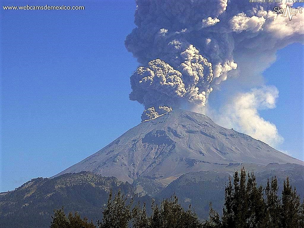
Popocatepetl , Mexico :
June 03, 11:00 am (June 03, 16:00 GMT)
During the last 24 hours, through monitoring systems of the Popocatepetl volcano, 159 low intensity exhalations accompanied by water vapor and gas have been identified. Among the most important events is noted the one that took place at 12:58. Also during this period were recorded three explosions, the first arrived yesterday at 12:15 pm, the other two yesterday at 03:44 h (and 05:16 pm.) The eruptive columns they generated had average heights from 1.5 to 2 km, which were scattered in a southwestern direction.
In addition, yesterday, a volcano-tectonic event was recorded at 16:13 with a magnitude of 1.6 M. Finally, during the night we observed an incandescence which increased during some episodes.
At the time of this report, the continuous emission of water vapor and other gases dispersed to the south is observed. The height of the column is less than 1 km.
CENAPRED asked not to approach the volcano and in particular the crater, because of the risk of falling of projectiles and in case of heavy rain to stay away from the bottom of the ravines because of the danger of landslides and mudslides .
The Popocatepetl volcanic warning light is located at Amarillo Phase 2.
Source : Cenapred.
Photo : Webcamdemexico ( archives 2017)
Merapi , Indonesia :
No eruption occurred after the last eruption on 01 June 2018 at 14:00 UTC
VOLCANO OBSERVATORY NOTICE FOR AVIATION – VONA.
Issued: June 03 , 2018
Volcano: Merapi (263250)
Current Aviation Colour Code: GREEN
Previous Aviation Colour Code: orange
Source: Merapi Volcano Observatory
Notice Number:2018MER13
Volcano Location: S 07 deg 32 min 31 sec E 110 deg 26 min 31 sec
Area: Special Region of Yogyakarta, Indonesia
Summit Elevation: 9498 FT (2968 M)
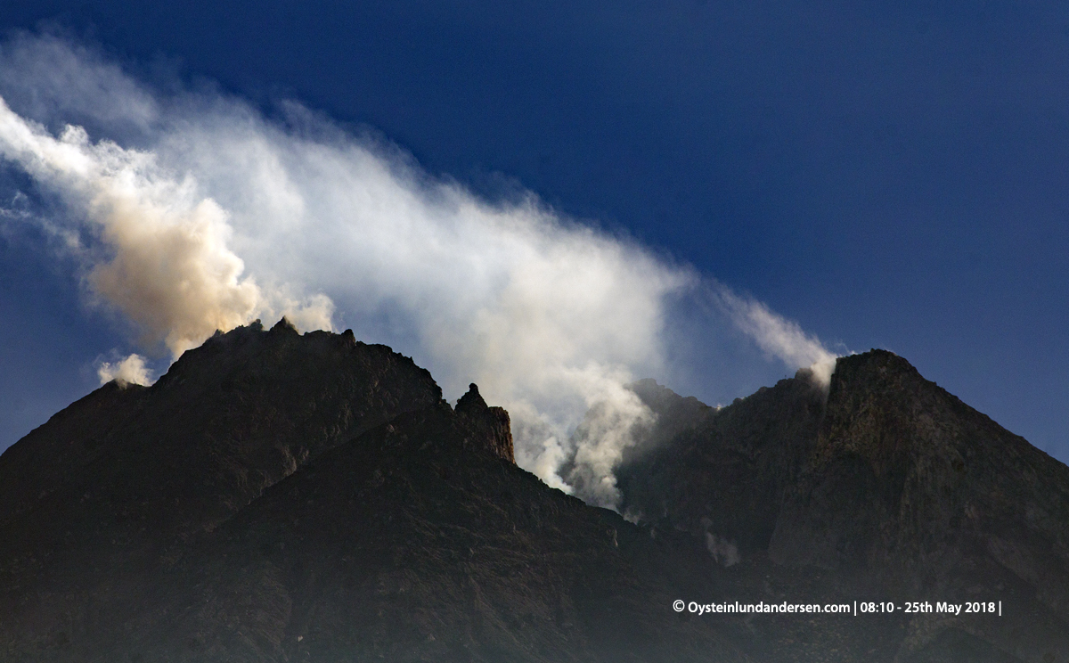
Volcanic Activity Summary:
No eruption occurred after the last eruption on 01 June 2018 at 14:00 UTC
Volcanic Cloud Height:
Best estimate of ash-cloud top is around 12058 FT (3768 M) above sea level, may be higher than what can be observed clearly. Source of height data: ground observer.
Other Volcanic Cloud Information:
White volcanic plume with low pressure and intensity
Source : Magma Indonesia
Photo : Oystein Lund Andersen http://www.oysteinlundandersen.com/