August 31 , 2018.
Hawaï , Kilauea :
19°25’16 » N 155°17’13 » W,
Summit Elevation 4091 ft (1247 m)
Current Volcano Alert Level: WATCH
Current Aviation Color Code: ORANGE
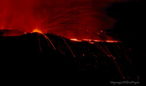
Kīlauea summit and lower East Rift Zone
Seismicity remains low and ground deformation is negligible at the summit of Kīlauea Volcano. Earthquakes, probably aftershocks of the magnitude-6.9 earthquake in early May, continue on South Flank faults. On the volcano’s lower East Rift Zone (LERZ), no incandescence was visible in the fissure 8 cone nor was there any lava entering the ocean during an overflight yesterday (8/29). Sulfur dioxide emission rates at the summit, Puʻu ʻŌʻō, and LERZ are drastically reduced; the combined rate (< 1,000 t/d) is lower than at any time since late 2007.
A view of fissure 8 from its front, with Luana St in the upper left corner.
HVO crews are working to restore communication with several monitoring stations on the east side of the island that was disrupted by the passage of Hurricane/Tropical Storm Lane but the losses do not significantly reduce our ability to assess volcanic conditions. Whiteout conditions could occur on the new lava field due due to steam produced by heavy rainfall on still-hot lava flows.
The Hawaiian Volcano Observatory (HVO) will continue to closely monitor Kīlauea’s seismicity, deformation, and gas emissions for any sign of reactivation, and maintain visual surveillance of the summit and LERZ as best we can. Ground and drone crews are in the field today but continue to be hampered by weather conditions.
HVO will continue to issue daily updates and additional messages as needed. The next update will be issued tomorrow morning unless significant changes occur.
Source : HVO
Photo : Bruce Omori
Indonesia , Anak Krakatau :
Level of Activity at Level II (WASPADA). G. Anak Krakatau (305 m above sea level) has experienced an increase in volcanic activity since 18 June 2018.
Since yesterday and until this morning, the volcano was covered with fog. The weak winds are oriented to the North-East and South-West. The smoke from the crater is not observed.
Thanks to the seismographs, on August 30, 2018, it was recorded:
145 earthquakes of eruptions
Continuous tremor with a maximum amplitude of 5-45 mm (dominant value 15 mm).
Recommendations:
The community / tourists are not allowed to approach the volcano within a radius of 1 km around the crater.
VONA:
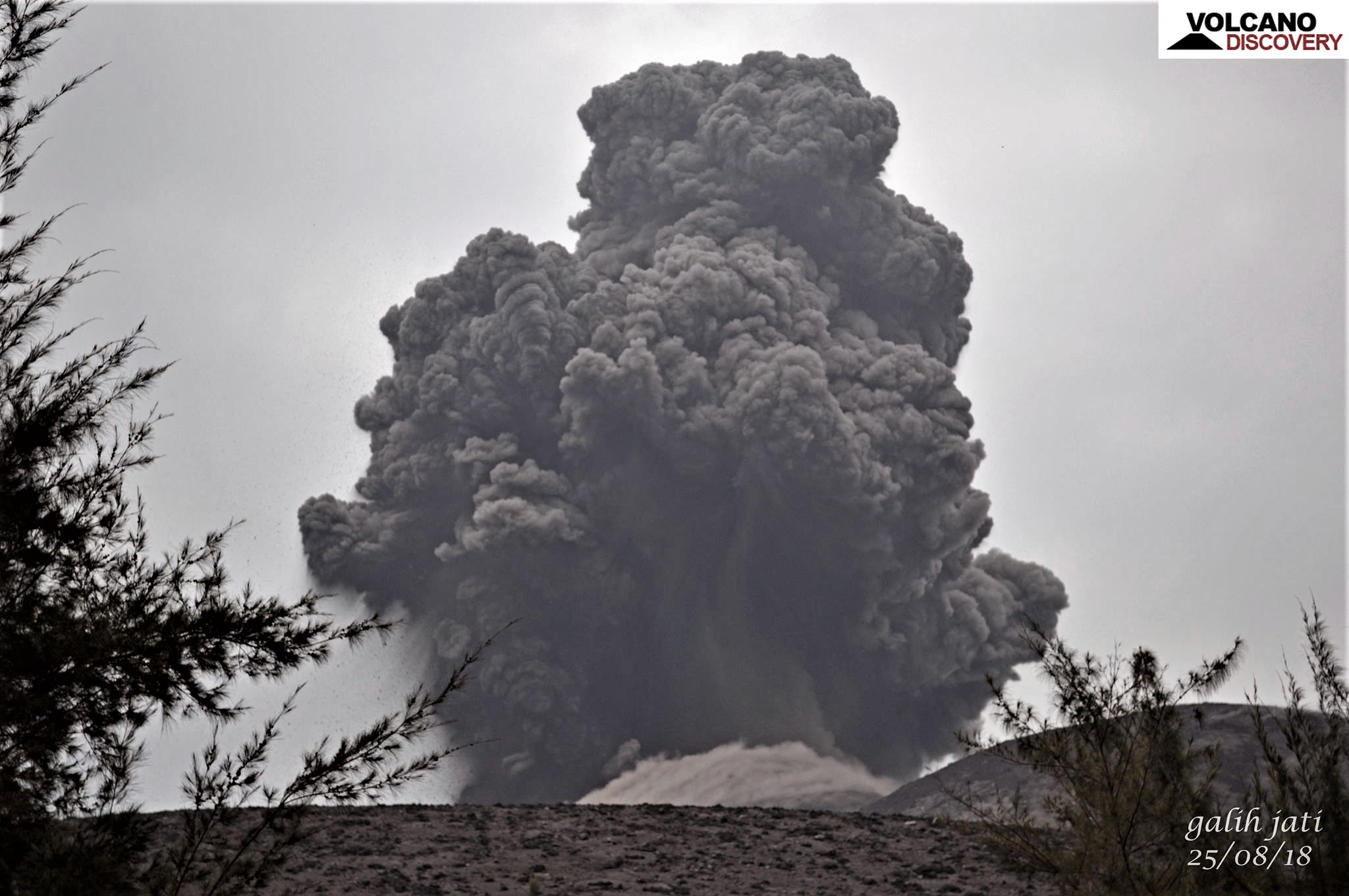
The last VONA bulletin was color-coded ORANGE, published August 23, 2018 at 6:07 pm WIB, related to the eruption recorded with a seismogram of maximum amplitude of 27 mm for a duration of about 31 seconds. The height of the eruption column was about 1005 m above sea level or 700 m above the peak. The column of ashes was moving north-east.
Source : PVMBG.
Photo : Volcanodiscovery / Galih Jati
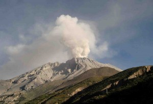
Chile , Lascar :
During the evaluated period, a total of 47 seismic events were recorded, of which 5 were classified as volcano-tectonic earthquakes (VT) in relation to rock fracturing processes inside the volcanic edifice. with local magnitudes less than M1. The event of greatest energy was located in the active crater, at a depth of 3 km. 42 long-period (LP) type earthquakes were also recorded in relation to fluid dynamics within the volcano with reduced displacement values (DRc) of less than 4.5 cm2.
The images provided by the IP cameras installed around the volcano show a recurrent degassing from the main crater, reaching a maximum of 300 m above the active crater.
According to the data provided by three GNSS stations, no displacement of the components is observed, which implies that there is no evidence of deformation for the period evaluated.
Sulfur dioxide (SO2) emissions, recorded by Differential Absorption Spectrometry Equipment (DOAS), have a value for the evaluated period of 1020 +/- 109 T / day and a maximum value of 2078 t / d recorded on 03 August. SO2 emissions are at moderate levels for this volcano.

4 thermal alerts were reported in the area associated with the volcanic complex during the period, with maximum radiated power (VRP), values considered low, according to the data processed by the infrared observation of volcanic activity (MIROVA) (http://www.mirovaweb.it/) and Temporal Thermal Monitoring of global hot spots (MODVOLC) (http://modis.higp.hawaii.edu/).
The current period is characterized by a significant decrease in seismic activity and the recording of low intensity thermal anomalies, suggesting that the volcanic system has not returned to equilibrium. For all this, it is not excluded the possibility of phreatic eruption.
Because of the above, the volcanic warning is kept at the level:
YELLOW LEVEL: Changes in the behavior of volcanic activity – Probable time for an eruption: WEEKS / MONTH.
Source : Sernageomin
Photo : Explore-Share.com.
Kamchatka , Ebeko :
VOLCANO OBSERVATORY NOTICE FOR AVIATION (VONA).
Issued: August 31 , 2018.
Volcano:Ebeko (CAVW #290380)
Current aviation colour code:ORANGE
Previous aviation colour code:orange
Source:KVERT
Notice Number:2018-77
Volcano Location:N 50 deg 41 min E 156 deg 0 min
Area:Northern Kuriles, Russia
Summit Elevation:3791.68 ft (1156 m)
Volcanic Activity Summary:
According to visual data, a moderate explosive activity of Ebeko volcano continues. Ash explosions sent ash up to 4 km a.s.l. and an ash cloud drifted to the east from the volcano.
A moderate gas-steam with some amount of ash activity of the volcano continues. Ash explosions up to 19,700 ft (6 km) a.s.l. could occur at any time. Ongoing activity could affect low-flying aircraft and airport of Severo-Kurilsk.
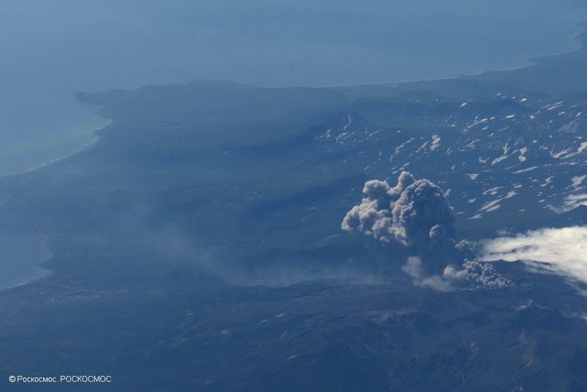
Explosive eruption of Ebeko volcano at 23:22 GMT on August 21, 2018.
Volcanic cloud height:
13120 ft (4000 m) AMSL Time and method of ash plume/cloud height determination: 20180830/2344Z – Visual data
Other volcanic cloud information:
Distance of ash plume/cloud of the volcano: 3 mi (5 km)
Direction of drift of ash plume/cloud of the volcano: E
Time and method of ash plume/cloud determination: 20180830/2344Z – Visual data
Start time of explosion and how determined: 20180830/2330Z – Visual data
Source : Kvert.
Photo : Roskosmos
Ecuador , Chalpatan :
Earthquakes in the area of Chalpatán volcano
On the night of August 27, 2018, a small earthquake swarm was detected in the area near Chalpatán Volcano in Carchi Province. To date, 143 events have been located in this sequence, with magnitudes between M0.1 and M3,2. The two most important events are an M3.1 that occurred on August 28 at 12:53 (TL) and an M3.2 on August 29 at 14:03 (TL). The second event was reported as felt by the inhabitants of the Tufiño area. This activity represents an increase over March of this year.
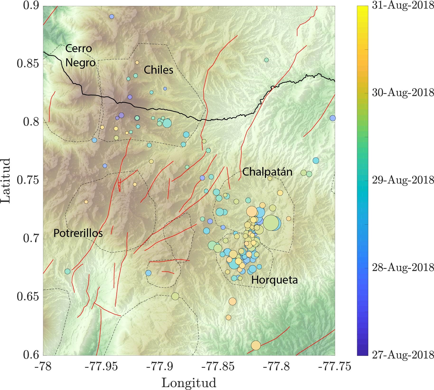
The seismicity in this swarm is slightly east of the Potrerillos seismicity reported in Special Report 5. The nearest region of the Chile-Cerro Negro volcanoes has a very small number of events during this last swarm.
The distribution of the swarm is about 5 km, aligned in a north-south direction (Figure 1), although, for the moment, there does not seem to be any obvious evidence of a horizontal migration. The approximate trend, N-S in this swarm is consistent with the general trend of known faults in this area. The faults in this region are generally oriented in the N-NE to S-SO directions (red lines in Figure 1). The depths associated with the swarm are generally shallow, with most events occurring at depths less than 10 km, with no tendency to become more or less deep. The evolution of magnitudes over time does not seem to show a classical sequence of the main events followed by their replicas, but rather a swarm as indicated.
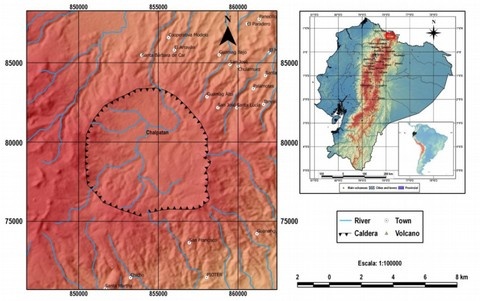
The Chalpatán volcano (3600 m altitude, 0.70 ° N, 77.79 ° W) is located north of the equator, 15 km southwest of Tulcán and 125 km north of Quito. It is found in inter-Andean depression. The Chalpatán is a volcano with a low relief and a large caldera 8 km in diameter
Interpretation
Due to the characteristics observed, this is another swarm like those that have been presented several times in recent years in this area. Its presence does not suggest any substantial changes in the volcanic complex, which maintains its level of seismicity similar to those observed in recent months; the other monitoring parameters also show no change. The Institute of Geophysics continues to monitor this activity and will report any significant changes in a timely manner.
Source : IGEPN